Coldest Air Since Last Winter in Alaska
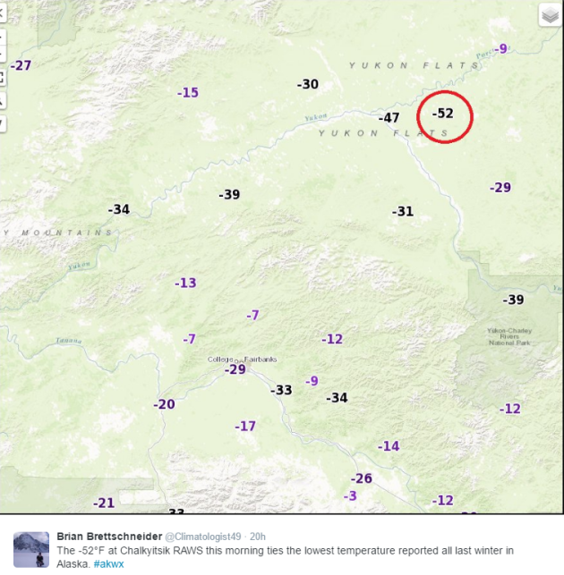
Thanks to @Climatologist49 for this tweet, which showed that an RAWS (Remote Automatic Weather Station) recorded a -52F temperature Wednesday morning, which ties the coldest temperature recorded in Alaska all of last winter.
 __________________________________________________________________________
"Record-Warm in Alaska"
__________________________________________________________________________
"Record-Warm in Alaska"
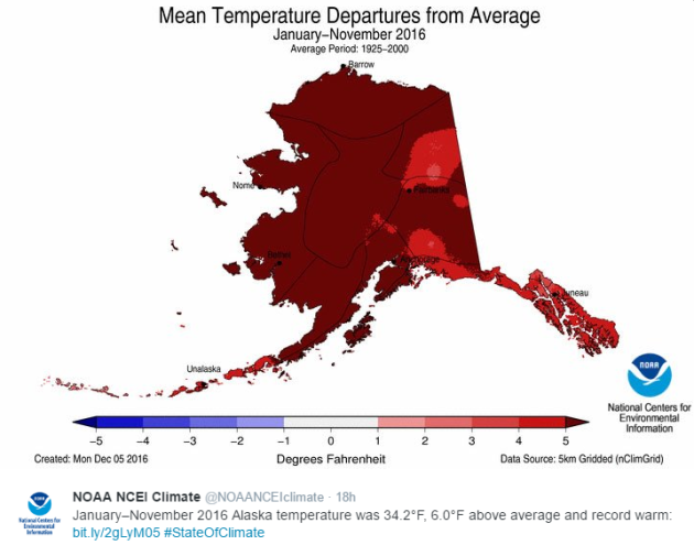
Despite recent cold weather in Alaska, the average statewide temperature from January through November was 6F above average and the warmest such period on record!
_______________________________________________________________________________
Arctic Plunges
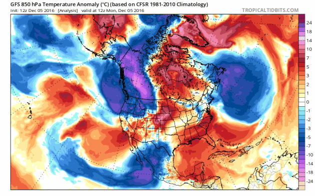
Take a look at the animation from Monday, December 5th to Thursday, December 15th below, which shows the development of the Arctic air plunging across the Lower 48 over the last few days. The animation also shows the continuation as another reinforcing shot even colder air surges south into next week.
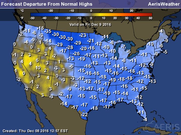
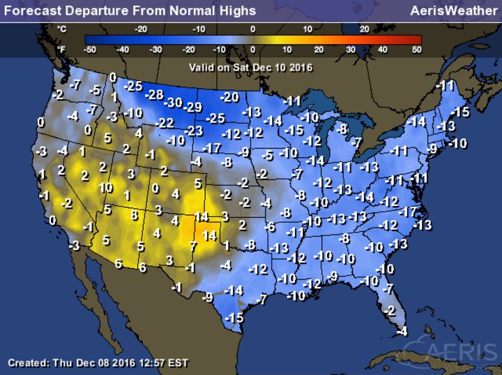
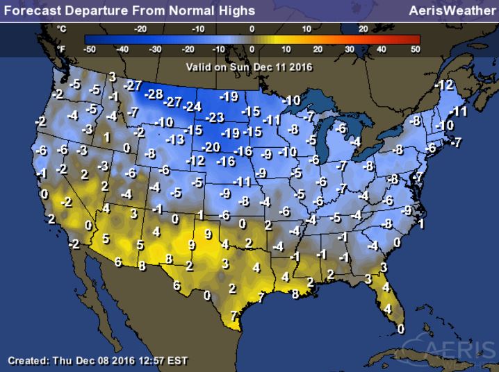
 High Temperatures From Average From Friday through Sunday
__________________________________________________________________
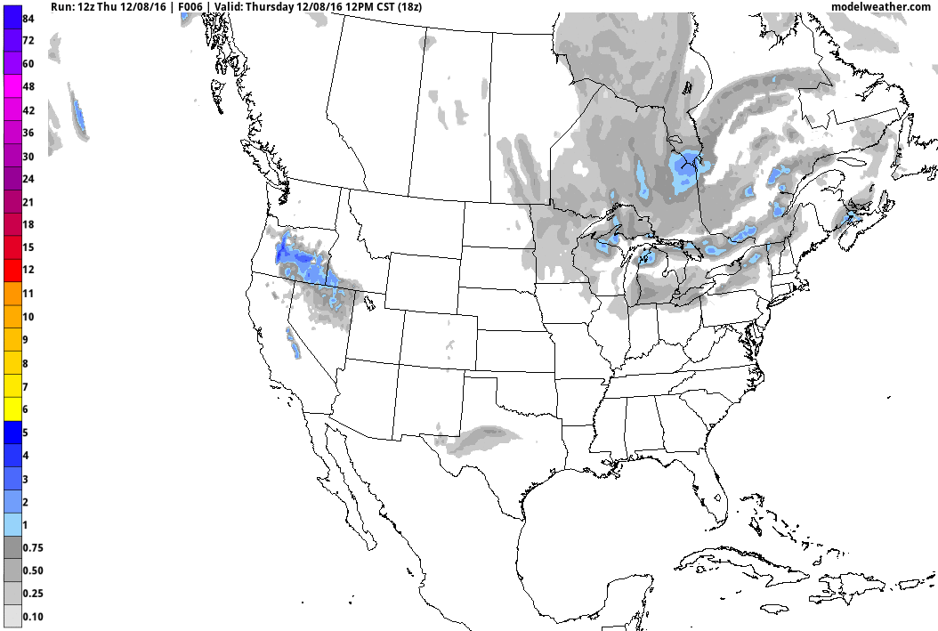
84-Hour Outlook
Here's the national weather outlook through Monday, which shows heavy lake effect snow continuing across the Great Lakes Region through the end of the week. The next surge of Pacific moisture will continue to slide into the Western US with heavy rain along the coast and heavy snow in the high elevations. The next wave of energy will develop into a snow maker across the Upper Midwest and the Great Lakes by the weekend. Note that there appears to be another surge of even heavier snow from across the Plains through the Ohio Valley/Great Lakes and into the Northeast by the early and middle part of next week.
.gif)
Thanks to @Climatologist49 for this tweet, which showed that an RAWS (Remote Automatic Weather Station) recorded a -52F temperature Wednesday morning, which ties the coldest temperature recorded in Alaska all of last winter.
Despite recent cold weather in Alaska, the average statewide temperature from January through November was 6F above average and the warmest such period on record!
_______________________________________________________________________________
Take a look at the animation from Monday, December 5th to Thursday, December 15th below, which shows the development of the Arctic air plunging across the Lower 48 over the last few days. The animation also shows the continuation as another reinforcing shot even colder air surges south into next week.
Arctic Air Surges South
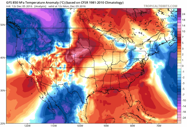
Here's the same loop as above (Monday, December 5th to Thursday, December 15th). Note how suddenly we've gone from much above average temperatures across the nation to much below average temperatures across the nation. Also note the secondary blob of Arctic air that funnels in over some of the same areas in the Eastern US next week. For some, this will be an even colder air mass than we we are currently dealing with.
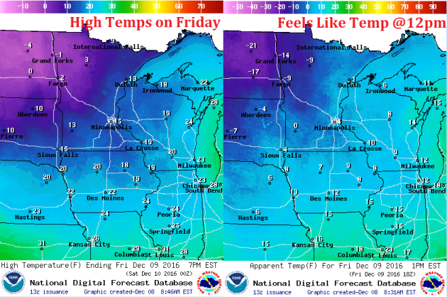
Here's a look at high temperatures from average across the nation Friday through Sunday and note that many locations will be nearly 10F to 20F colder than average! Some spots along the Front Range of the Rockies could be nearly 30F below average then... BRR!
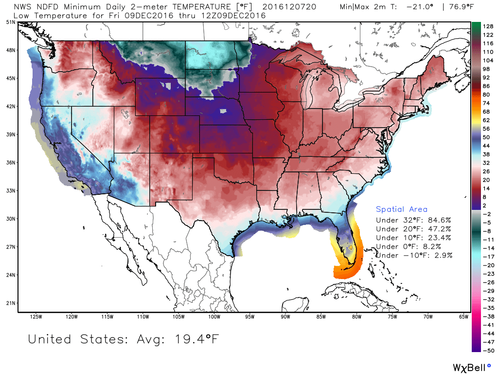
Much of the Nation Below Freezing Friday Morning
Friday morning appears to be the most widespread (cold) morning of the week with nearly 85% of the nation seeing low temperatures below freezing! The coldest air will be found in the High Plains where some spots across North Dakota could drop into the teens below zero! Wind chills there could be in the 20s below zero by Friday morning too!
_________________________________________________________________________
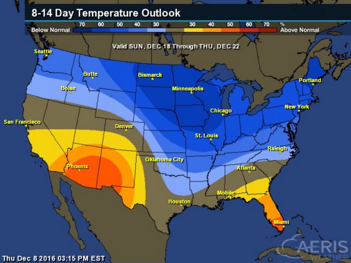
8 to 14 Day Temperature Outlook
According to NOAA's Climate Prediction Center, the 8 to 14 day temperature outlook suggests that colder than average temperatures will be with much of us in northern tier of the nation and across much of the eastern half of the country. The coldest of which will be found across the Upper Midwest and Great Lakes Region. With that said, look for several bouts of lake effect snow over the next couple weeks.
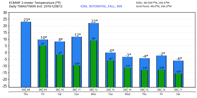
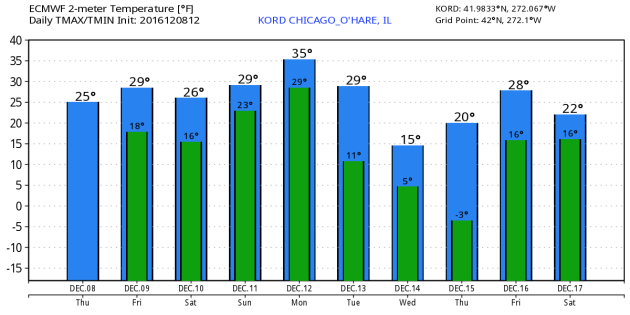
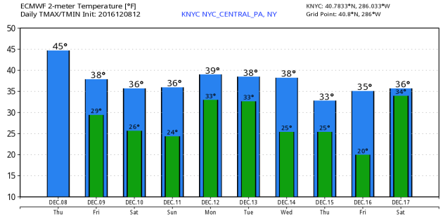
Extended Outlook for KINL - KORD - KNYC
Take a look at the extended outlook for International Falls, MN - Chicago, IL - New York, NY - which shows colder temperatures through the rest of the week and weekend ahead. Especially note the forecast into next week for International Falls, MN, where high temperatures could actually be below zero. That secondary surge of Arctic air is also evident in Chicago, IL as temperatures dip even further by midweek next week. Even though the air mass will be modified later next week, you can still see a drop in temps for New York, NY by the end of next week.
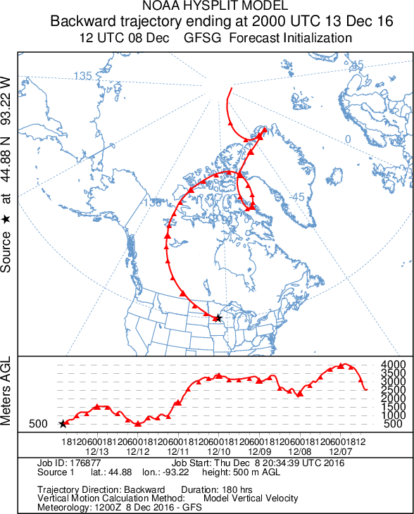
Backwards Trajectory Model
Here's an interesting look at the backwards trajectory of the air mass that will be in place by Tuesday, December 13th in Minnesota. Note that the origins are traced back directly from the Arctic; almost from the North Pole... Hey Santa!
__________________________________________________________________
Here's the national weather outlook through Monday, which shows heavy lake effect snow continuing across the Great Lakes Region through the end of the week. The next surge of Pacific moisture will continue to slide into the Western US with heavy rain along the coast and heavy snow in the high elevations. The next wave of energy will develop into a snow maker across the Upper Midwest and the Great Lakes by the weekend. Note that there appears to be another surge of even heavier snow from across the Plains through the Ohio Valley/Great Lakes and into the Northeast by the early and middle part of next week.
10-Day Snowfall Outlook
Here's the 10 day snowfall potential, which shows heavier snow across the Great Lakes Region and the higher elevations in the Western U.S.. A steady stream of Pacific moisture may translate into heavier snow over the next several days across parts of the northern tier of the nation. Some of these events could produce shovelable/plowable amounts of snow across a wider area that could impact many across the country. Now that colder air is in place across the country, any moisture that moves through will have a better chance of falling in the form of snow.
Here's the 10 day snowfall potential, which shows heavier snow across the Great Lakes Region and the higher elevations in the Western U.S.. A steady stream of Pacific moisture may translate into heavier snow over the next several days across parts of the northern tier of the nation. Some of these events could produce shovelable/plowable amounts of snow across a wider area that could impact many across the country. Now that colder air is in place across the country, any moisture that moves through will have a better chance of falling in the form of snow.
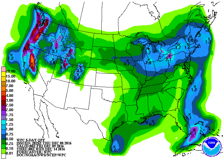
5 Day Precipitation Outlook
According to NOAA's WPC, the 5 day precipitation outlook suggests heavy precipitation in the Western US, especially along the coast in the higher elevations. Some spots could see as much as 3" to 7"+ liquid through early next week. Much of the precipitation in the Western US will fall in the form of heavy snow in the mountains. Some spots could see 1ft. to 2ft. of snow through the weekend. Also note the heavy moisture around the Great Lakes, which will fall in the form of heavy lake effect snow over the next several days! There will also be some decent liquid tallies across parts of the Tennessee Valley and into Kentucky, which will further help the drought.
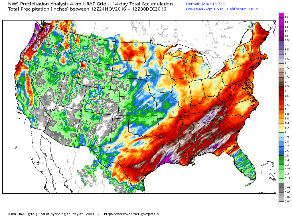
Rainfall Past 14 Days
Take a look at the precipitation over the last 14 days. Note the heaviest swath from parts of eastern Texas through the Gulf Coast States and Tennessee Valley. Some spots have seen nearly 6" to 10"+ over that time period, which is wonderful news conditions these are some of the areas under the worst drought.
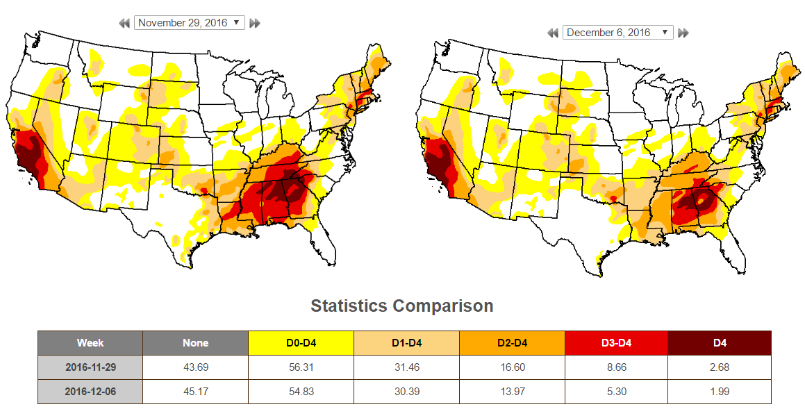
US Drought Monitor
According to the US Drought Monitor, there has been a decent improvement in the national drought. The biggest change comes in the extreme category that went from 8.66% national down to 5.3% nationally. Much of this improvement was seen in the Southeast.
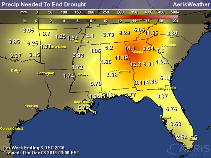
Precipitation Needed to End Drought in the Southeast
Even after all the rain we've seen in the Southeast, we still need several more inches of rainfall to end the drought there. Some spots still need another 6" to 10"+.
______________________________________________________________________________
My oh my, it sure is cold out there! It's not that we haven't seen weather like this before, it's just that it came so suddenly.
Remember that high temps topped out around 40 degrees on Monday and dropped 20 to 30 degrees by Tuesday after the Arctic front blew through. We haven't seen readings like this since February; 10 months ago. Unless you have a plane ticket south or are planning on locking yourself in a sauna, we're going to have to endure these colder temps for the foreseeable future. In fact, it looks even colder next week with highs in the single digits and lows dipping below zero. Last time it was that cold in December was back in 2014.
Enjoy calmer winds Friday with a few peeks of cold sunshine. Clouds increase Saturday in advance of our next snow event that looks to bring plowable snow to the southern half of the state. At this point, the heaviest looks to fall along the MN/IA border with lighter amounts in central Minnesota.
Minnesota remains drought free. Through Dec. 8th, MSP has been the 6th wettest year on record.
___________________________________________________
Extended Weather Outlook
THURSDAY NIGHT: Mostly cloudy and cold. A few lingering flurries. Winds: WNW 5-10. Low: 10.
FRIDAY: Less wind, still cold. Peeks of sun. Winds: WNW 5. High: 15.
FRIDAY NIGHT: Mostly cloudy and cold. Winds: WNW 5. Low: 5
SATURDAY: Shovel-worthy PM snow develops in southern MN. Winds: E 10-15. High: 17.
SUNDAY: Lingering light snow. Winds: ENE 5. Wake-up: 15. High: 20.
MONDAY: A few flakes. Turning colder. Winds: E 5-10. Wake-up: 10. High: 15.
TUESDAY: Another Arctic blast. Winds: WNW 10-15. Wake-up: 2. High: 6.
WEDNESDAY: Some sun. Icy winds. Winds: W 10-15. Wake-up: -5. High: 8.
THURSDAY: Face-numbing wind chills continue. Winds: W 10-15. Wake-up: 3. High: 7.
_______________________________
_______________________________
This Day in Weather History
December 9th:
2003: Significant snow with amounts between 6 to 10 inches falls from southwest Minnesota across the Minneapolis-St. Paul area and into west central Wisconsin. Winds across the area were 25 to 30 mph, with blowing and drifting snow in open areas. Although some parts of far south central Minnesota only picked up 4 to 6 inches, winds in this area were a little stronger, creating near-blizzard conditions. The greatest snowfall totals occurred in the Twin Cities metro, where Chaska, Chanhassen and New Hope all picked up 11 inches. Ten inches were recorded at Lamberton, Springfield and Gaylord. There was a sharp cutoff on the northern edge of the snow; Lamberton in southernmost Redwood County tallied 10 inches, while 25 miles to the north at Belview in far northern Redwood County, only 2 inches was recorded. Rockford, straddling the Hennepin/Wright County line, received 6 inches, whereas Buffalo, 10 miles to the northwest in central Wright County, only received 1 inch.December 9th:
1995: The passage of a strong low pressure system on the 8th leads to wind chill readings of 50 to 75 below as strong northwest winds of 25 to 40 mph ushered significantly colder air across the region. The dangerously cold wind chill readings persisted through the morning of the 9th.
1961: A snowstorm hits central Minnesota. Mora gets about a foot.
________________________________
Average High/Low for Minneapolis
December 9th
Average High: 29F (Record: 58F set in 1939)
Average Low: 14F (Record: -27F set in 1876)
Average Low: 14F (Record: -27F set in 1876)
Record Snowfall: 10.5" set in 2012
_________________________________
_________________________________
Sunrise/Sunset Times for Minneapolis
December 9th
December 9th
Sunrise: 7:39am
Sunset: 4:32pm
Sunset: 4:32pm
*Daylight Lost Since Yesterday: ~57sec
*Daylight Lost Since Summer Solstice: ~6hours and 42mins
______________________________________________________________________
*Daylight Lost Since Summer Solstice: ~6hours and 42mins
______________________________________________________________________
Moon Phase for December 8th at Midnight
1.9 Days Since First Quarter
1.9 Days Since First Quarter

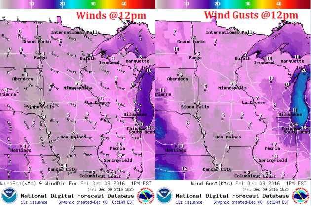
Weather Outlook Friday
High temperatures on Friday will be a little colder than what we've been dealing with over the past couple of days. The good thing is that winds won't be quite as strong as they've been earlier this week, so it won't feel quite as bad. Note that a few locations across northwestern MN will still feel like the single digits and teens below zero by midday.
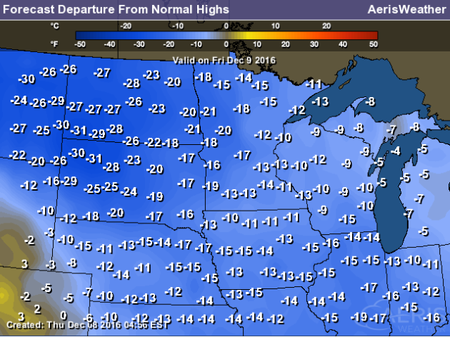
High Temperatures From Average Friday
Here's a look at high temperatures from average on Friday and much of the Upper Midwest will be nearly 10F to 25F below average. This continued colder than average weather looks to continue right through next week!
Weather Outlook Friday
The nice thing about Friday is that winds will be much lighter than they were earlier this week. The winds won't be quite as icy as they were PM Tuesday and Wednesday.
Weather Outlook Friday
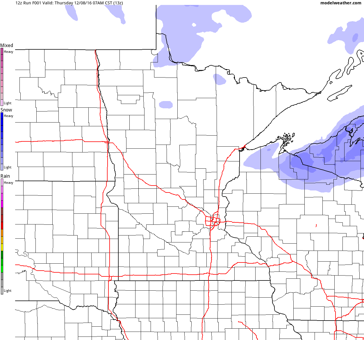
Weather conditions across the state look pretty quiet. Other than a few lingering flurries across the international border and Arrowhead, we should stay mainly dry until Saturday. There may even be a few more peeks of sun by the afternoon. Meanwhile, heavy lake effect snow continues along the south shore of Lake Superior.

___________________________________________________________
Simulated Radar
The simulated radar from Thursday to PM Saturday shows continued lake effect snow on the south shore of Lake Superior and mostly quiet conditions across the state until Saturday. Shovelable snow is looking likely for many across the southern half of the state through PM Saturday through AM Sunday.
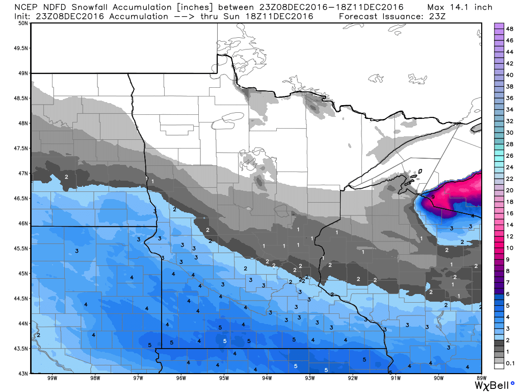
Snowfall Potential
Here's the snowfall potential through midday Sunday, which shows our next round of snow pushing in across the southern half of the state through the day Saturday and wrapping up early Sunday. Latest model runs keep the heaviest snowfall across the southern part of the state with much light amounts in central Minnesota and almost nothing in the northern part of the state.
Somewhat Active Pattern With Colder Temps Ahead.
Here's the weather outlook through Monday. Note the heavy lake effect snow ongoing across the Great Lakes Region before another surge of snow quickly plows through the Upper Midwest on Saturday and Sunday. This will be responsible for some plowable snow from south of Minneapolis to Madison, WI and Chicago, IL. Quickly after that, another larger snow event looks to take shape.
.gif)
__________________________________________________________________________
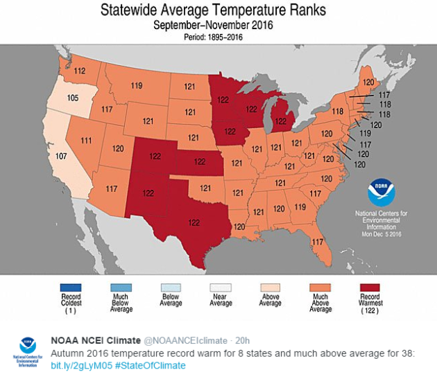
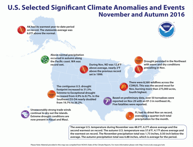
According to NOAA, if you lived in Minnesota, Wisconsin, Iowa, Michigan, Colorado, Kansas, New Mexico or Texas, you just lived through the WARMEST autumn (September - November) on record! As a whole, the contiguous U.S. also had its warmest autumn on record as the average temperature ran nearly 4F above average!
See more from NOAA's State of the Climate HERE:
______________________________________________________________________________
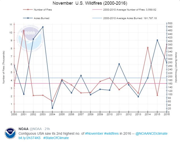
According to NOAA, there were nearly 8,560 wildfires across the Lower 48 during the month of November, which becomes the 2nd highest number of wildfires during the November.
"Wildfires: In November, 8,560 wildfires raged across the Continental U.S. and burned more than 275,000 acres, most notably in the Southeast."
See more from NOAA HERE:
Here are some of the most noteworthy climate events that happened during November and Autumn of 2016. Note that much of these climate events included either warmer than average temperatures or drought/wildfire concerns.
-Drought: The area of extreme to exceptional drought in the Lower 48 increased from 4.9% to 8.7%; in -the Southeast it nearly doubled from 19.7% to 36.2%.
-Wildfires: In November, 8,560 wildfires raged across the Continental U.S. and burned more than 275,000 acres, most notably in the Southeast.
-North Dakota experienced temperatures 12.8 degrees F above average, nearly 2 degrees above the previous record set in 1999.
-Alaska experienced its warmest year to date on record, a full 6 degrees F above average.
Pacific Northwest experienced above-normal precipitation during autumn along the coast. Washington state was record wet.
See more from NOAA HERE:
________________________________________________________________________________
"Cassini Beams Back First Images from New Orbit"
Unreal! Cassini, a satellite that was launched in 1997 to explore Saturn, is sending back new images and they are pretty amazing! Here's an excerpt from NASA:
"NASA's Cassini spacecraft has sent to Earth its first views of Saturn’s atmosphere since beginning the latest phase of its mission. The new images show scenes from high above Saturn's northern hemisphere, including the planet's intriguing hexagon-shaped jet stream. Cassini began its new mission phase, called its Ring-Grazing Orbits, on Nov. 30. Each of these weeklong orbits -- 20 in all -- carries the spacecraft high above Saturn's northern hemisphere before sending it skimming past the outer edges of the planet's main rings."See more from NASA HERE:

_________________________________________________________________"NASA Made a Really Dumb Mistake on an ISS Power Supply"
"The INTERNATIONAL SPACE STATION is currently home to six intrepid astronauts, one Robonaut, and four 14,000-pound payload-holders called ExPRESS Logistics Carriers. Experiments from Earth like the laser-communicator OPALS fly up to Station and Lego-attach to these carriers, which provide them with a place to stay and, just as importantly, the electrical power and data links they need to do their jobs. But since 2013, scientists sending up payloads have had trouble with the on-orbit utility grid."
See more from WIRED HERE:
(Image Credit: NOAA)

________________________________________________________________________________
Thanks for checking in and don't forget to follow me on Twitter @TNelsonWX

No comments:
Post a Comment