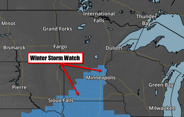
Winter Storm Watch
A messy winter storm system impacting the Central US with a significant ice event, will eventually head in our direction by the early week time frame. At this point, a mixture of snow and ice is possible for us and for that reason, the National Weather Service has issued a Winter Storm Watch from AM Monday to AM Tuesday. The good news is that most folks will be off of work and school with the observance of Marin Luther King Day.
...WINTER STORM TO IMPACT SOUTH CENTRAL INTO EAST CENTRAL MINNESOTA LATE SUNDAY NIGHT INTO TUESDAY MORNING...
A WINTER STORM WATCH HAS BEEN ISSUED FROM LATE SUNDAY NIGHT INTO TUESDAY MORNING FROM THE I-35 CORRIDOR WEST TO A LINE FROM REDWOOD FALLS TO CAMBRIDGE. A WINTRY MIX OF FREEZING RAIN...SLEET...AND SNOW IS EXPECTED WITH THIS SYSTEM. THE POTENTIAL EXISTS FOR SEVERAL INCHES OF SNOW ALONG WITH THE THREAT FOR SIGNIFICANT ICE ACCUMULATIONS IN EXCESS OF A QUARTER OF AN INCH. SIGNIFICANT TRAVEL IMPACTS ARE EXPECTED MONDAY INTO TUESDAY. IN ADDITION...IF SIGNIFICANT ICE ACCUMULATIONS ARE EXPERIENCED...SCATTERED POWER OUTAGES COULD OCCUR AS WELL DUE TO ICE ACCUMULATION ON TREES AND POWER LINES.
* A MIX OF FREEZING RAIN...SNOW...AND SLEET ARE POSSIBLE FROM MONDAY MORNING THROUGH TUESDAY MORNING.
* TOTAL SNOW ACCUMULATIONS UP TO 6 INCHES AND ICE ACCUMULATIONS UP TO A QUARTER OF AN INCH ARE POSSIBLE.
* SIGNIFICANT REDUCTIONS IN VISIBILITY ARE POSSIBLE.
* PLAN ON DIFFICULT DRIVING CONDITIONS...INCLUDING DURING THE EVENING COMMUTE ON MONDAY.
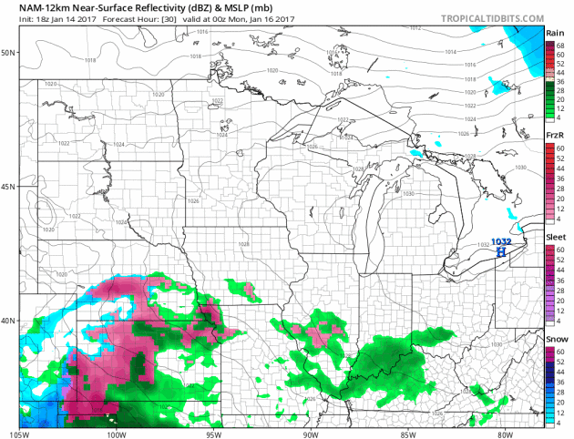
Simulated Radar
Here's the simulated radar as our next storm system surges north into the Upper Midwest late PM Sunday through AM Tuesday. Unfortunately, this is another storm that will bring a multitude of different precipitation types to the area with a mixture of rain, freezing rain, sleet and snow. Freezing rain will be a major travel concern where some locations could see up to 1/4" ice. There may also be some shovelable snow on the colder side of the storm as it lifts northeast through the early week time frame.
Brilliant Winter Day Sunday. Major Snow Melt Ahead
If you're an outdoor winter enthusiast, do anything you can to get outside and enjoy it Sunday! Fresh snow, sunshine and near average temps will make this one of the nicest winter days of the season.
A major ice storm unfolding in the Central U.S. will continue lifting north on Sunday. It'll be on our doorstep Monday with a wintry mixture of freezing rain and snow. Winter weather headlines have been posted for parts of the state, including the Twin Cities for the potential of ice and shovelable snow from AM Monday to AM Tuesday. Good news is that most won't have to venture out MLK Day Monday, but your AM Tuesday commute could be a little iffy.
The extended forecast shows impressively warm temps in place with highs in the 30s and 40s through the last full week of January. I'm afraid to say it, but that nice fresh snow pack will take a major hit. There's even a chance for RAIN on Friday and Saturday, which won't be good for outdoor hockey rinks.
What a weird winter. Can't it ever just be normal? Seize the moment. Get out there Sunday!
_____________________________________
_____________________________________
Extended Forecast:
SATURDAY NIGHT: Mostly clear, quiet and chilly. Low: 4
SUNDAY: Another brilliant winter day. Clouds increase late. Winds: SSW 5. High: 27
SUNDAY NIGHT: Increasing clouds. Winds: S 5. Low: 15
MONDAY: Wintry mix develops. Some snow and ice. Winds: ESE 5-10. High: 31
TUESDAY: Mostly cloudy, lingering flurries. Winds: WNW 5-10. Wake-up: 24. High: 30
WEDNESDAY: January thaw begins... Winds: S 5-10. Wake-up: 22. High: 34
THURSDAY: More clouds and mild. Winds: SSW 7-12. Wake-up: 25. High: 40
FRIDAY: Mostly cloudy. Scattered PM rain showers. Winds: ESE 5-10. Wake-up: 32. High: 41
SATURDAY: Light rain, snow melt continues. Winds: SSW 5-10. Wake-up: 31. High: 37.
_______________________________________________________________________________
_______________________________________________________________________________
This Day in Weather History
January 15th
January 15th
1972: Cold air invades the region with a minimum temperature of -33 degrees F at Alexandria, -32 at Eau Claire, and -29 at the Minneapolis-St Paul International Airport.
_______________________________________________________________________________
_______________________________________________________________________________
Average High/Low for Minneapolis
January 15th
January 15th
Average High: 23F (Record: 43F set in 1990)
Average: Low: 7F (Record: -37F set in 1888)
_______________________________________________________________________________
Average: Low: 7F (Record: -37F set in 1888)
_______________________________________________________________________________
Sunrise Sunset Times For Minneapolis
January 15th
January 15th
Sunrise: 7:47am
Sunset: 4:58pm
Sunset: 4:58pm
*Daylight Gained Since Yesterday: ~1 minute 48 seconds
*Daylight Gained Since Winter Solstice (December 21st): ~25 minutes
________________________________________________________________________________
*Daylight Gained Since Winter Solstice (December 21st): ~25 minutes
________________________________________________________________________________
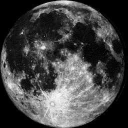
Moon Phase for January 14th at Midnight
2.8 Days After Full "Wolf" Moon
2.8 Days After Full "Wolf" Moon
__________________________________________________________________________________
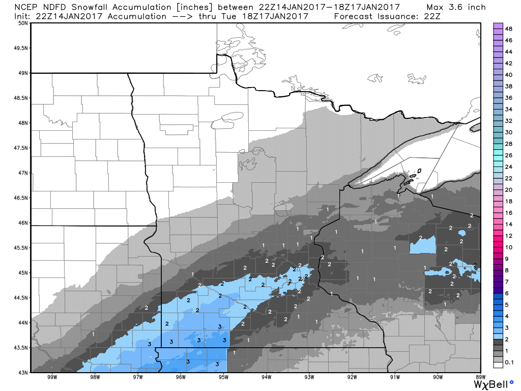
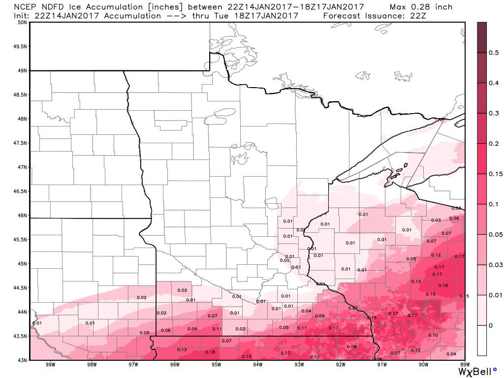
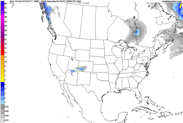
Snowfall Potential
As our next system approaches from the South later this weekend/early next week, a wintry mix will be possible. We are looking at the potential of rain, freezing rain and snow through Tuesday. Below are the snowfall and icing amounts possible through midday Tuesday.
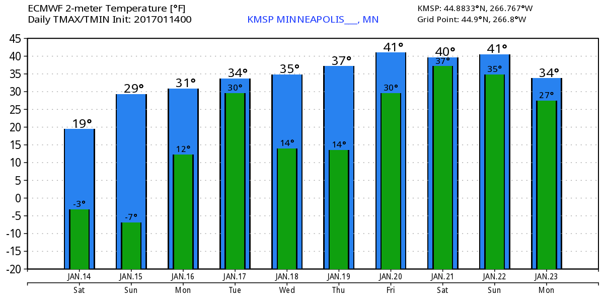
Extended Temperature Outlook for Minneapolis
Here's the temperature outlook through January 23rd, which shows a VERY mild trend heading into the week ahead with highs in the 30s and even 40s by next weekend! With several days above freezing, our snow pack will likely take a big hit... we may also have a fog concerns with melting snow and added moisture in the lower levels of the atmosphere.
___________________________________________________________________________________
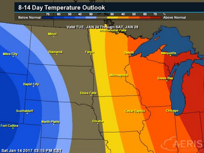
6 to 10 Day Temperature Outlook
According to NOAA's CPC, the 8 to 14 day temperature outlook suggests warmer than average temperatures continuing across much of the Upper Midwest from January 24th to January 28th. With that said, extended models are suggesting temperatures returning to near normal levels by the end of the month. Looking ahead, there doesn't appear to be any major cold snaps brewing over the next couple of weeks.
_________________________________________________________________________________
Major Ice Event Central US
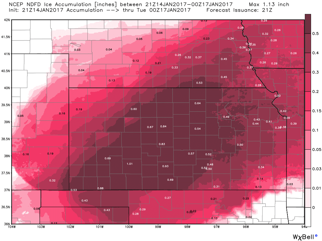
Thanks to the National Weather Service in St. Louis, MO for this picture, which shows the icing that took place there through AM Saturday. This will likely be a crippling event for some folks in the Central Plains through the weekend with widespread power outages. This is a serious storm and has already proven to be fatal.
Major Ice Event Central US
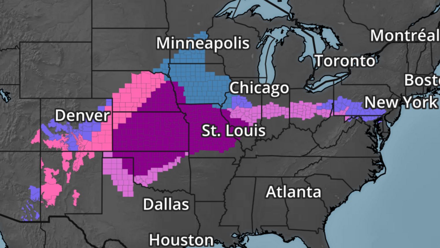
Take a look at all the winter weather headlines across the country and note the deep purple coloring from the Oklahoma and Texas Panhandle to the Central U.S.. Those are Ice Storm warnings, where up to 1/2" of ice or more could accumulate, which will cause major travel impacts and even power outages.
Ice Storm Warning
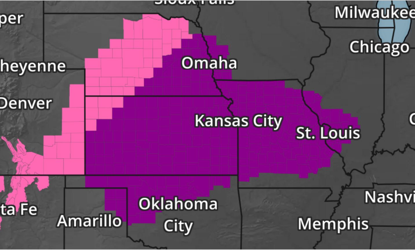
The most significant icing will take place across the Central U.S., where Ice Storm Warnings have been posted. Some spots could see as much as 1/2" to near 3/4" ice, especially across Kansas.
Icing Potential
Here's the icing potential in Kansas through Monday, which suggests up to 1/2" to near 3/4" of ice, which would likely cause major travel issues and power outages. Kansas looks like it may see some of the worst icing this system has to offer, but widespread 1/4" to near 1/2" amounts elsewhere will still create major issues.
Simulate Radar
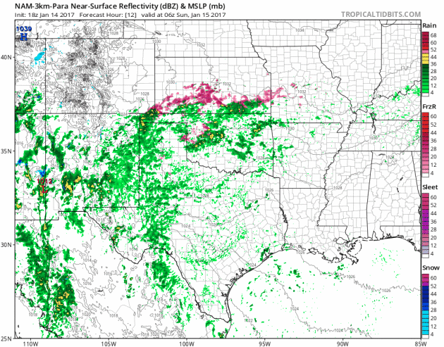
Heres' the simulated radar from early AM Sunday to AM Monday, which shows rounds of icy rains continuing across the Central Plains through the weekend before changing to all rain. This wintry mess will begin moving north into the Upper Midwest by late weekend/early next week.
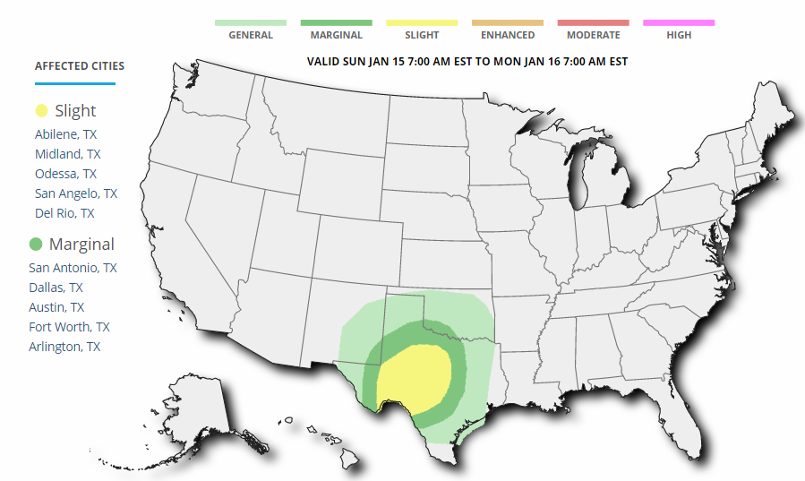
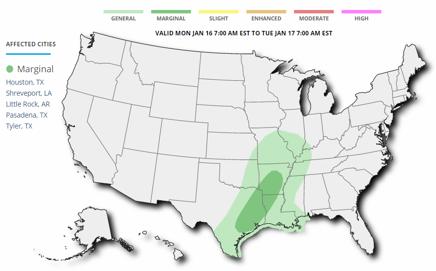
Severe Storm Threats
As the storm system slowly moves northeast through the Central U.S., strong to severe storms will also develop on the southern flank of this storm system. Below are the severe storm outlooks for Sunday and Monday. Note that a SLIGHT Risk of severe weather has been issued on Sunday across parts of Texas for the potential of large hail, isolated wind damage and even an isolated tornado. The threat lessens slightly on Monday as a MARGINAL risk has been issued, where strong winds and hail will be the primary concerns.
_____________________________________________________________________________
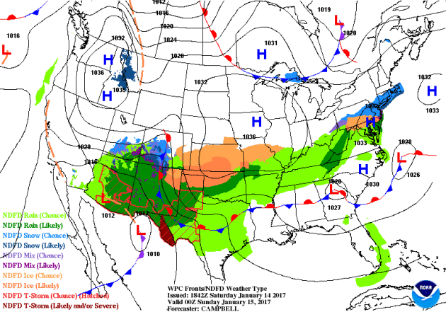
National Weather Outlook
Here's the national weather outlook through early next week, which shows the large storm system in the Central U.S. responsible for major icing concerns in the middle part of the country. This storm system will also bring widely scattered showers and storms to the Southern U.S. with isolated strong to severe storms and heavy rainfall.
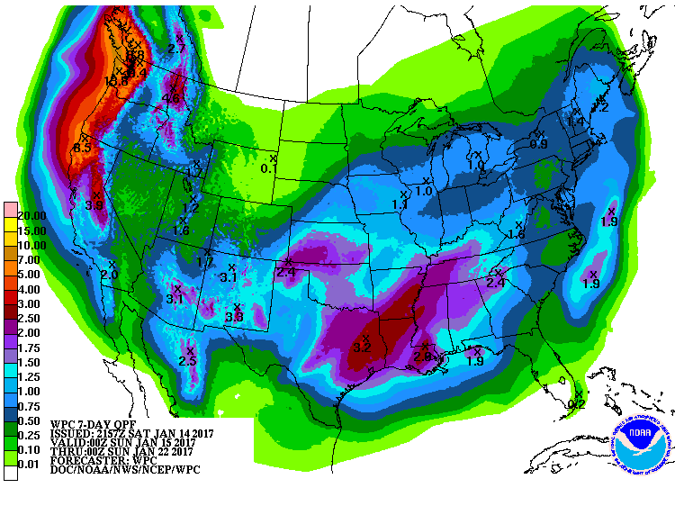
7 Day Precipitation Forecast
According to NOAA's WPC, the 7 day precipitation forecast suggests widespread 1" to 3"+ rainfall amounts across the Southern U.S.. Also note the heavy moisture moving back into the West U.S., especially along the West Coast. Some 6" to 12"+ liquid tallies can't be ruled out from northern California to western Oregon and western Washington. There may even be some 1" to 2" tallies across parts of southern California through next weekend.
Snowfall Potential
The extended forecast calls for additional heavy moisture in the Western U.S. with heavy snow in the high elevations. Note that widespread heavy snow looks to fall from the Cascades to the Sierra Nevada Range to parts of the Rockies. The additional heavy snow in the Sierra Nevada Range is wonderful news for the upcoming water supply during the summer months for parts of California.
_________________________________________________________________________________
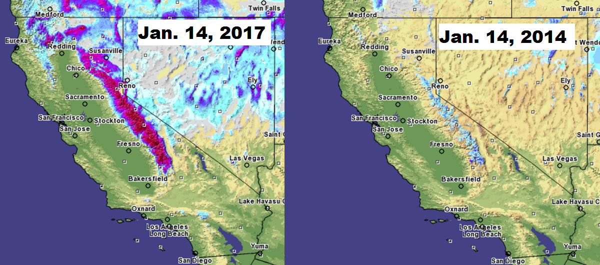
California Snow Comparison
California has been a significant drought over the last several years, but has made some improvements thanks to recent heavy precipitation. Take a look at the snow depth comparison from January 14th, 2014 vs 2017. Currently, FEET of snow is on the ground vs the very little snow pack that was on the ground in 2014 and in 2015.
_____________________________________________________________________________
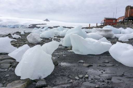
"Climate change shows in shrinking Antarctic snows"
"Vast icy rock peaks tower above Argentina's Carlini research base in Antarctica. But scientists who have worked here for decades say the glaciers are less icy than they once were. For international experts stationed at the base, the frozen southern continent is a good gauge of climate change. "When I used to come to Antarctica in the 1990s, it never used to rain," said Rodolfo Sanchez, director of the Argentine Antarctic Institute (IAA). "Now it rains regularly—instead of snowing," he told AFP during an Argentine government visit to King George Island, off the tip of the western Antarctic peninsula. Scientists monitoring conditions at the base say the average temperature here has increased by 2.5 degrees Celsius (4.5 degrees Fahrenheit) over the past century."
______________________________________________________________________________
"Beginning of the End of CA Drought, But What’s Next?"
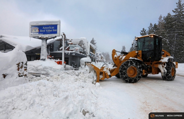
"After a week of being walloped by major storms that have dumped copious rain and snow on the state, California is finally emerging from a deep, years-long drought. Ski resorts in the Sierra Nevada mountains are flush with snow, while key reservoirs have filled back up. On Thursday, the U.S. Drought Monitor erased all drought in Northern California from the map and dialed back the severity over the southern half of the state. There are, of course, still major deficits in groundwater levels that could take decades to replace and lingering ecological impacts, several experts said, but they agreed the situation had much improved. “I think overall we’ve gotten through this drought amazingly well,” Jay Lund, a water resources analyst at the University of California, Davis, said. One key concern going forward is how global warming may alter California’s notoriously boom-or-bust climate: Does it mean more, and more intense, drought? Will it strengthen the storms that bring the state most of its water? The current view is that it could mean both, effectively amping up the already wild variation the state experiences, though there is still uncertainty about some of the potential impacts of warming."
(A plow clears snow after a heavy winter storm in Tahoe City, Calif. Credit: REUTERS/Bob Strong)
___________________________________________________________________________
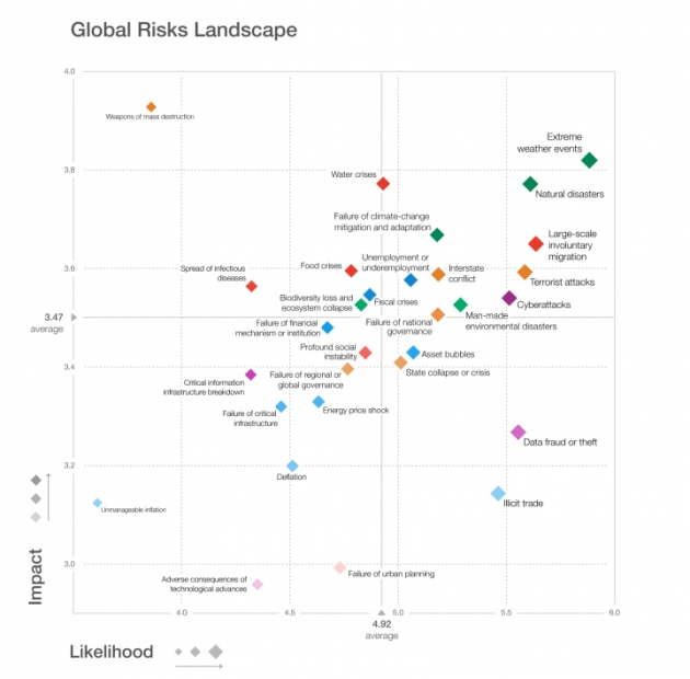
"Climate Change Is the World’s Biggest Risk, in 3 Charts"
The rise of the machines isn’t the biggest threat to humanity. It’s climate change, extreme weather and other environmental factors. The World Economic Forum surveyed 750 experts on what the most likely and impactful risks facing humanity are in 2017. In a report released Thursday, they ranked extreme weather as the most likely risk and the second-most impactful, trailing only the use of weapons of mass destruction. Climate change is responsible for driving an increase in the likelihood and intensity of extreme weather events, notably heat waves. Failing to adapt to or mitigate climate change and a host of other climate-connected risks including water and food crises and involuntary migration also rank in the top 10.
_____________________________________________________________________________
Thanks for checking in and don't forget to follow me on Twitter @TNelsonWX

No comments:
Post a Comment