32 F. high yesterday in the Twin Cities.
24 F. average high on January 2.
31 F. high on January 2, 2016.
January 3, 1981: Arctic air visits Minnesota. Embarrass, Wannaska, and Tower all hit 38 below zero.
January 3, 1977: 14.2 inches of snow falls in Mankato.
 Arctic Exhaust: No Records But "Cold Enough"
I
had a fleeting out-of-body conversation yesterday. "Yeah, it won't be
so bad" I explained. "Single digit highs, maybe 4 nights below zero, as
cold as -7F or so. No big deal". Where else can a meteorologist utter
such a thing. Fairbanks? Grand Forks? Bozeman, Montana? And it dawned on
me once again: Minnesotans are a race of super-humans.
"Weather Ballers" my friends out east call us, with a mix of awe and reverence. I agree.
Yesterday's
rain and ice was a bit odd. Then again Dr. Mark Seeley reports a 4X
increase in midwinter rain in the Twin Cities since 2000.
A cruel,
unforgiving northwest wind kicks in today; another airmail treat direct
from the Yukon. In spite of a pleading sun temperatures are stunted in
low single digits
Wednesday into
Saturday, metro lows sinking to -5 to -10F.
Temperatures
warm into the 20s, above zero! early next week; the next shot of
premium, Canadian air not as cold late next week. Long-range models hint
at a milder, Pacific breeze kicking in the 3rd week of January. No big
snows coming but plenty of ice for outdoor hockey rinks this winter!
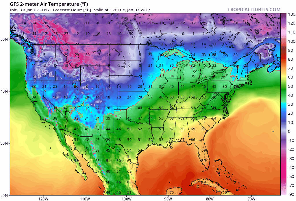
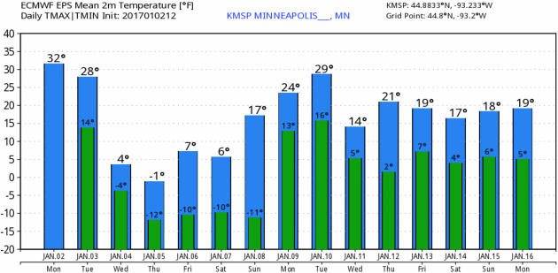
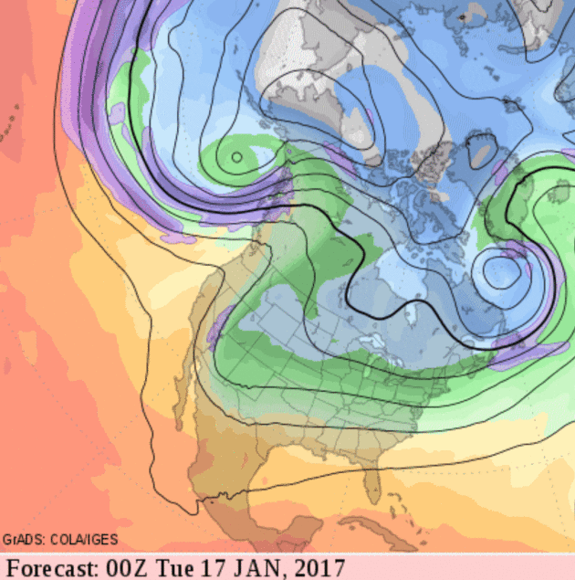
384 hour 2-meter GFS temperature forecast: NOAA and Tropicaltidbits.com.
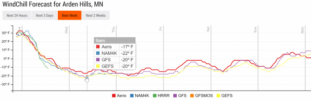
Coldest Wind Chill: Wednesday Morning.
Models are showing slightly stronger sustained winds Wednesday morning,
making it teel like -20 to -25F in the metro area. Not as cold as
December 18, but odds are it'll get your attention. Wind chill plot:
Aeris Enterprise.
Coldest Air Temperature: Thursday Morning.
As winds ease a bit under mostly clear skies radiational cooling will
drag the mercury into the -5 to -8F range aroun 7 AM Thursday morning.
Again, it was -20F in the metro on December 18. This time the chill
lingers an extra day or so, but the intensity won't be as brutal as it
was in mid-December.
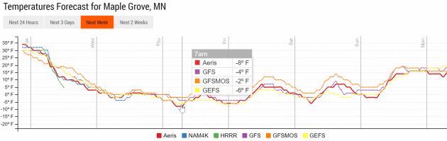
Handful of Numbing Days, Then "Milder".
Only in Minnesota would teens and 20s be interpreted as milder, but
next week should feel considerably better than it's going to feel
Wednesday into Saturday, when metro temperatures hold in single digits
with 4 or 5 subzero nights.
 Southeastern Snow Event Next Weekend?
Confidence levels are still very low, but NOAA's GFS model spins up a
storm along the leading edge of much colder air, with potentially
plowable snowfall amounts from Oklahoma City to Birmingham, Atlanta and
the Carolinas. Too early to panic, but we need to keep an eye on this.
Moderation Third Week of January.
Models continue to indicate a more zonal, west-to-east flow within 2
weeks as the core of the coldest air lifts toward Newfoundland. Old Man
Winter may catch his breath for a week or so later this month, but
spring fever is nowhere in sight.
Coldest Country on Earth?
Yes, Antarctica is colder, but it isn't a country. There are a lot of
ways to quantify "coldest nation", including aerial coverage of bitter
cold, the most extreme low temperature, etc, but Russia, specifically
Siberia, has top honors, according to
Science Facts: "
Russia's
winters have stopped invading armies. Rather than entering into peace
negotiation with Napoleon Bonaparte, who had already conquered most of
Europe by 1812, Tsar Alexander decided to let Russia's grim climate
handle the French invaders. Summers in the Russian tundra are brief.
Snow and rain visit this vast stretch of land at least eight months
throughout the year. In 1974, a record temperature of 96 degrees below
zero Fahrenheit was recorded in northeast Siberia. Russia is the coldest
country in the world." (File photo credit: Wikipedia).
 The Term "Severe Weather" May Not Mean What You Think. There is still confusion about terminology, according to Marshall Shepherd at Forbes: "...If a severe thunderstorm watch or a tornado watch is issued, this is what that means according the the SPC website
A
Severe Thunderstorm Watch outlines an area where an organized episode
of hail 1 inch diameter or larger and/or damaging thunderstorm winds are
expected during a two to eight hour period. A Tornado Watch includes
the large hail and damaging wind threats, as well as the possibility of
multiple tornadoes or a single intense tornado. Typical watches cover
about 25,000 square miles, or about half the size of Iowa.
Though
it varies, the SPC issues about 1000 or so watches per year. SPC only
issues watches. Warnings are issued by your local National Weather
Service (NWS) office. A watch means that the outlined conditions above
are possible during the next few hours or so. A warning means that
conditions have actually been observed or expected within the next 60
minutes. According to some studies (and my own personal observations), a “not-trivial” percentage of the population actually confuses these terms..."
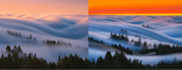
Fog Waves: Photographer Nick Steinberg Captures Nature in Motion.
Digital Photography Review has a few samples of some truly incredible photos: "
Out
of almost daily trips to Mt.Tam in the summer of 2016, I would say that
this was by far the best flow i’d seen. Normally the rangers kick
everyone out around sunset, but on this evening they came really late
and allowed me to get some rare footage of fog coming in at twilight.
What I loved about this one was the layers of fog coming through the
trees. The beautiful and vibrant red sky was unfortunately lit up due to
a nearby fire..."
Photo credit: Nick Steinberg.
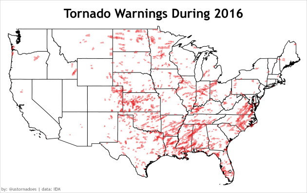
Tornado Warnings in 2016. Map courtesy of
U.S. Tornadoes,
which points out that the heavy warning density from central North
Carolina to southern Virginia during the February 24, 2016 outbreak was
the largest of last year.
La Nina May Drive More Tornadoes in 2017.
It was a relatively quiet 2016 for tornadoes, but a La Nina cool phase
in the Pacific may help to spark more numerous and violent tornadoes in
spring of 2017, according to
EcoWatch: "...
The strong El Niño of 2015-16 likely helped tamp down tornado activity this year, at least in the heart of Tornado Alley. Researchers at IRI/Columbia University
have shown that the most active spring seasons for tornado and hail
over the central U.S., especially the Southern Plains, are linked to
strong La Niña events, while the very quietest seasons are related to
strong El Niño events. In January 2015,
the researchers, led by John Allen (now at Central Michigan
University), called for better-than-even odds (54 percent) of a
below-average number of tornadoes this year, as opposed to the 33/33/33
percent split (below, above, and near average) one would otherwise
expect. (See more details at this conference presentation).
As with Atlantic hurricanes, even a mostly quiet season can still
produce deadly mayhem if one destructive event, such as a major
landfalling hurricane or a family of violent tornadoes, happens to hit
the wrong place at the wrong time. "It's an ongoing challenge to think
about how to convey this information," Allen told me. "I think it's also
worth noting that we still don't have a lot of other climate signals
for improving our forecasts when we don't have ENSO-driven
predictability..."
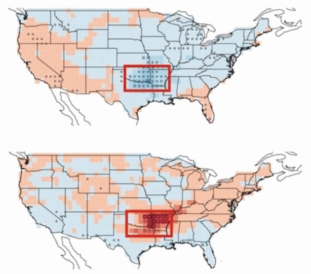
Map credit: "
During El Nino
events (top) the frequency of U.S. tornadoes typically drops. When a La
Nina phase prevails (bottom) tornado frequency goes up (indicated by red
areas). The effect is strongest in the boxed area." Nature Geoscience 2015, courtesy IRI.
2016 Weather In Review Around the USA...
A Look Back at New England's Year in Weather. Here's an excerpt of a good recap from WBZ-TV,
CBS Boston: "...
A
T-storm moved through eastern Worcester County, then through central
Middlesex County. Isolated wind damage was reported in Marlborough and
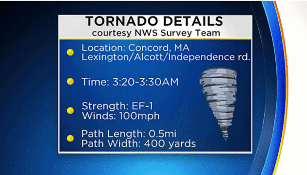
Sudbury, then it produced a tornado. Concord was hit by the tornado,
classified as an EF-1 by the National Weather Service. This was the
first tornado warning since August 4th of 2015. First
Massachusetts tornado since June 23, 2015 (Westminster/Wrentham). And,
the first “nocturnal” tornado since July 11, 1970 (2:15am in Townsend).
More info on the damage here..."
Image credit: "
Concord experienced a tornado in the summer." (WBZ-TV)
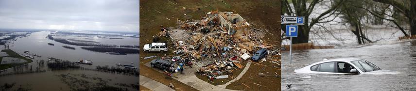
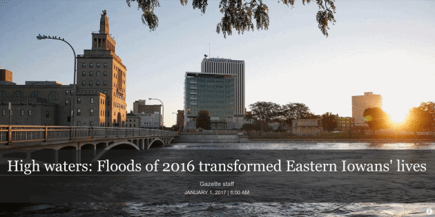
High Waters: Floods of 2016 Transformed Eastern Iowans' Lives. Cear Rapids and much of eastern Iowa experienced near-record flooding last year. Here's an excerpt from
The Gazette: "...
In
Cedar Rapids, where the Cedar River created at 21.9 feet on Sept. 27 —
the highest since the historic 2008 flood — the city still is figuring
the cost of a gargantuan effort to stave off what could have been a far
worse calamity. In the aftermath, 19 Iowa counties became eligible for
federal assistance to help rebound from at least $22 million in damage
caused by extensive flooding along the Cedar River from Sept. 21 to Oct.
3, President Barack Obama declared. The Gazette’s online readers voted the Cedar Rapids flooding as the story of the year for 2016..."
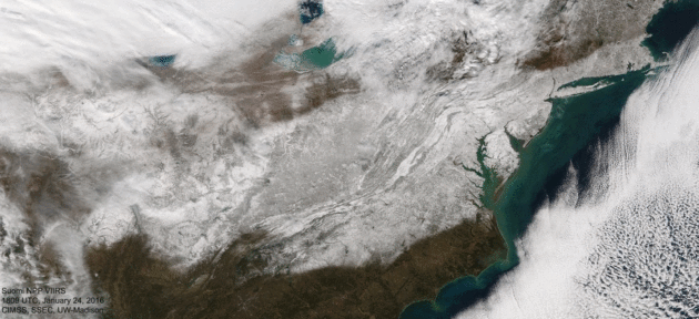
Snowzilla Tops List of 2016's Most Significant Weather Events in Washington D.C. Here's a clip from
Capital Weather Gang: "...
When all was said and done, a controversial 17.8 inches
of snow was recorded at Reagan National Airport for the District’s
total, enough to tie as the fourth biggest on record. Folks like me in
the northwest part of the city recorded 2 feet. Baltimore picked up 29.2
inches, its largest snowstorm on record, and Dulles International
Airport recorded 29.3 inches which ranked No. 2. What made Snowzilla
truly unique was that the District and most of the region picked up 80
to 85 percent of an above-average snowfall season in this one storm.
Throughout recorded history, there is no other winter with that kind of
stat. The closest was 1941-1942, also an El Niño winter, when 80 percent
of the snow fell in one storm in late March. But that was a smaller
storm, and the seasonal snowfall finished below average..."
Image credit:
UW-Madison CIMSS
Top Story of 2016: Thousand Year Flood. Southern West Virginia was hit especially hard in late June. Here's a recap from
Register-Herald.com: "
A
day that dawned with severe thunderstorms and torrential downpours and
ended in tragedy, June 23 undoubtedly will go into the Mountain State's
history books as the day of the thousand-year flood. Southern West
Virginia's hardest hit area, Greenbrier County, saw 11 inches of rain
fall in less than 12 hours that Thursday, according to Emergency
Management director Al Whitaker. Affecting 44 of the state's 55
counties, the downpour caused flash flooding of small streams through
neighborhoods that had never before seen a flood. In many places, that
water drained into nearby rivers; the Greenbrier, Meadow, Elk, Gauley,
Cherry and New all peaked above flood stage. Swept away in the
floodwaters were roads and bridges, parks and schools, homes and
businesses and, most dear, 23 lives — 15 in Greenbrier alone..."
Photo credit: Rick Barbero, The Register-Herald. "
A house was forced from its foundation and floated onto Anjean Street in Rupert had to be cut in half to open up the lane."
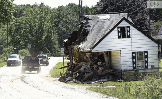
Top 6 Southwest Florida Weather Events in 2016.
Fox4 in Fort Meyers, Florida has a recap: "
From
tornadoes to summer storms, hurricanes to record heat, 2016 has been a
year of some wild weather across Southwest Florida. Here's a list of 6
of the top weather events this year. Last winter was marked by El Niño, a
pattern favoring more active weather for Florida, including a greater
occurrence of severe storms and tornadoes. In mid January, a rare EF2
tornado struck SW Cape Coral leaving a trail of downed trees, damaged
homes and devastation. More instances of tornadoes and damaging winds
would occur with impacts felt in Fort Myers, Port Charlotte, Naples and
Golden Gate..."
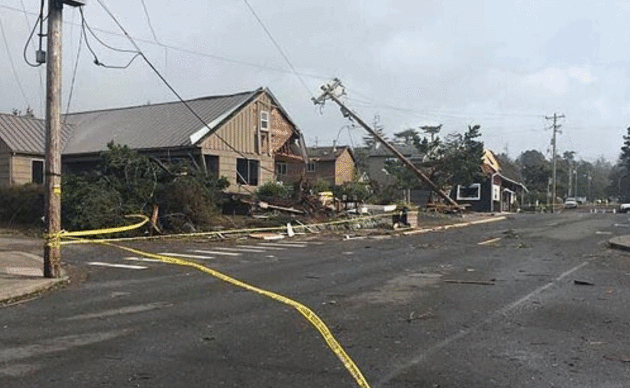
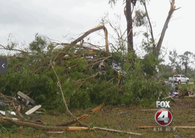
Freakish EF-2 Tornado for Coastal Oregon in 2016.
Beachconnection.net reviews the strong tornado that shocked residents of Oregon in 2016: "...
The highest profile event on the entire Oregon coast took place in Manzanita and Oceanside on October 14 when both places had a tornado lumber through.
In Oceanside there was no damage, but Manzanita had over 100 homes and
buildings torn apart, power lines ripped out and the town was actually
cordoned off for a few days. Most dramatically, the town lost one third
of its trees. It was later designated and EF2. Footage of the event even
made national TV news. Almost as big a story was why this happened.
Tornadoes along the coast are nearly unheard of. According to the
National Weather Service (NWS), this one was the combination of a lot of
different elements coming together, some of them quite unusual. The NWS
called the storm itself “rare,” in that it was a low pressure system
that coincided with a storm that was atypically strong for this time of
year, making things so much more unstable..." (Photo credit: Amy Van Dyck).

How To Defrost Your Car Windshield In Less Than a Minute. I stumbled upon this suggestion at
Travel + Leisure: "...
But Ken Weathers, a meteorologist for the WATE 6 news station in Tennessee, wants to make your winter mornings
just a little bit more bearable. Growing up in the Midwest, I know all
of the tricks: turn your car on ten minutes before you plan on leaving,
expensive defrost spray, buy one of those strange pairs of gloves that
has an ice scraper built in. No one method is foolproof nor anywhere
near seamless. But Weathers has a homemade solution that will only take
you a minute to make—you probably already have the necessary
ingredients—and will make defrosting your windows as easy as taking a
lap around your car. Mix two-third parts of rubbing alcohol with
one-third part of water. Put it in a spray bottle, and you're set for
the worst of winter months. Once this solution hits the window, the ice
melts right away in seconds..."
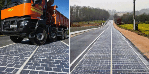
World's First Solar Road Opens in France.
EcoWatch has details: "...
According to the Guardian,
about 2,000 motorists will drive on the roadway during a test period of
two years to see if the project can generate enough energy to power
street lights for the 3,400-resident village. The panels consists of
extremely thin yet durable panels of polycrystalline silicon that can
transform solar energy into electricity. The panels are designed to
withstand all types of traffic, including heavy-duty vehicles and in
terms of efficiency, Wattway claims
its panels have a 15 percent yield, compared to 18-19 percent for
conventional photovoltaic panels. The French government plans to
eventually pave 1,000 kilometers (621 miles) of its roads with solar
panels. "The maximum effect of the program, if successful, could be to
furnish 5 million people with electricity, or about 8 percent of the
French population," Royal said earlier this year about the iniative..."
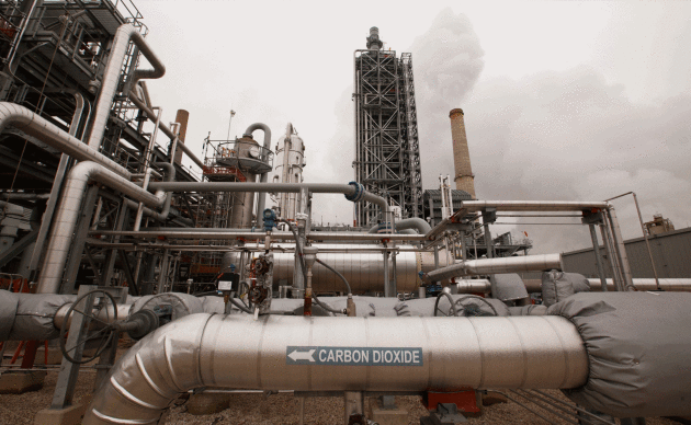
Can Carbon Capture Technology Prosper Under Trump? Here's the intro to a
New York Times story: "
Can one of the most promising — and troubled — technologies for fighting global warming
survive during the administration of Donald J. Trump? The technology,
carbon capture, involves pulling carbon dioxide out of smokestacks and
industrial processes before the climate-altering gas can make its way
into the atmosphere. Mr. Trump’s denial of the overwhelming scientific
evidence supporting climate change, a view shared by many of his cabinet
nominees, might appear to doom any such environmental initiatives. But
the new Petra Nova plant about to start running here, about 30 miles
southwest of Houston, is a bright spot for the technology’s supporters.
It is being completed essentially on time and within its budget, unlike
many previous such projects..."
Photo credit: "Carbon capture equipment at the Petra Nova plant southwest of Houston." Credit Michael Stravato for The New York Times.
HGTV Will Never Upset You: How The Network Beat CNN in 2016. Say what? Here's an excerpt from
Bloomberg: "...
The
escapist appeal of looking at other people’s beautiful homes turned
Home & Garden Television into the third most-watched cable network
in 2016, ahead of CNN and behind only Fox News and ESPN. Riding HGTV’s
reality shows, parent company Scripps Networks Interactive Inc. has seen its shares rise more than 30 percent this year, outperforming bigger rivals like Walt Disney Co., 21st Century Fox Inc. and Viacom Inc.
HGTV’s formula is relentlessly consistent: a shabby house gets a
makeover, and a happy couple moves in. A variation on the theme --
house-flipping for fun and profit -- works too. The network has aired 23
different flipping shows over the past few years. Today “Flip or Flop”
and “Masters of Flip” run in prime time..."
Photo credit: "
Drew and Jonathan Scott of HGTV’s Property Brothers." Photographer: Zack Arias/Used Film Studios via ScrippsNetworks.
French Employees Can Legally Ignore Work E-Mails Outside of Office Hours. Somehow I doubt this is coming to the USA anytime soon.
The Washington Post reports: "
That
10 p.m. email from your boss? It's your right to ignore it. That
Saturday ping from a colleague with “just one quick question?” A
response on Monday should suffice. If you're in France, that is. French
workers rang in a new year at midnight — as well as a “right to
disconnect” law that grants employees in the country the legal right to
ignore work emails outside of typical working hours, according to the Guardian..."
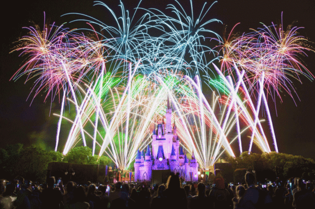
Visiting Disney World is the Modern Version of Making a Medieval Pilgrimage. Yep, I did a double-take too, but check out the post at
Atlas Obscura: "
At
Walt Disney World, the weeks around Christmas are one of the most
crowded times of the year: from all over the country and all over the
world, families flock to Orlando to be in this special space for just a
few days. Most Disney patrons would probably call their trip a vacation,
but to anthropologists, religious studies experts, and art historians, a
visit to Disney World looks a lot like another, older form of travel—a
pilgrimage. “Appetites for direct contact with Disney’s
creations have transformed the trek to Disney World into a genuine form
of pilgrimage,” writes historian Cheryl Krause Knight, author of Power
and Paradise in Walt Disney’s World..."
Photo credit: "
The Magic Kingdom."
Anthony Quintano/CC BY 2.0
TODAY: Gusty, feels like -5F. Temperatures tumble into the teens. Winds: NW 15-25. High: 21 (early)
TUESDAY NIGHT: Partly cloudy. Low: -2
WEDNESDAY: Some sun, feels like -20F. Winds: NW 10-15. High: 4
THURSDAY: Arctic sunshine, feels like -25F. Winds: NW 8-13. Wake-up: -4. High: 2
FRIDAY: Clouds, few flurries. Not quite as numb. Winds: NW 5-10. Wake-up: -5. High: 8
SATURDAY: Blue sky, Dog Days of Winter. Winds: NW 8-13. Wake-up: -3. High: 5
SUNDAY: Clouds and winds increase. Winds: S 10-20. Wake-up: 0. High: 19
MONDAY: Few flurries, feels a little better. Winds: NW 10-15. Wake-up: 15. High: 24
Climate Stories...
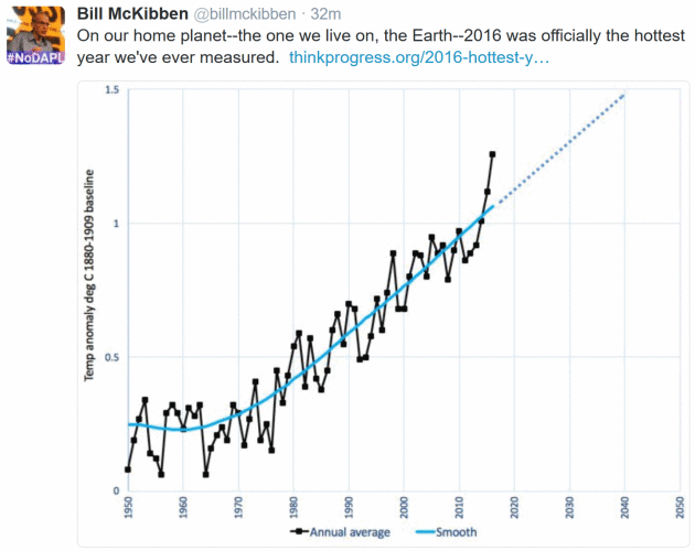
 Top 10 Tropical Cyclone Events of 2016 Potentially Influenced by Climate Change. Jeff Masters reports for "Category 6" at WunderBlog: "Tropical
cyclones—which include all hurricanes, typhoons, tropical storms and
tropical depressions—are expected to change in intensity, frequency,
location, and seasonality as a result of climate change. Many of the
tropical cyclones of 2016 exhibited the type of behavior we expect to
see more of due to global warming. Here, then, is a “top ten” list of
2016 tropical cyclone events of the type we should expect to see more of
due to global warming. Tropical cyclones are heat engines which extract
heat energy from the oceans and convert it to the kinetic energy of the
storms' winds. Thus, the strongest tropical cyclones are expected to
get stronger in a world with warmer oceans. It was not a surprise that
in 2016—a year with the warmest ocean temperatures on record,
globally—we saw the strongest storms ever observed in the two of the six
ocean basins that tropical cyclones commonly occur in. If we include
the Northern Hemisphere’s strongest tropical cyclone on record—Hurricane
Patrica of October 2015—records have been set in three of the six ocean
basins over the past two years
Top 10 Tropical Cyclone Events of 2016 Potentially Influenced by Climate Change. Jeff Masters reports for "Category 6" at WunderBlog: "Tropical
cyclones—which include all hurricanes, typhoons, tropical storms and
tropical depressions—are expected to change in intensity, frequency,
location, and seasonality as a result of climate change. Many of the
tropical cyclones of 2016 exhibited the type of behavior we expect to
see more of due to global warming. Here, then, is a “top ten” list of
2016 tropical cyclone events of the type we should expect to see more of
due to global warming. Tropical cyclones are heat engines which extract
heat energy from the oceans and convert it to the kinetic energy of the
storms' winds. Thus, the strongest tropical cyclones are expected to
get stronger in a world with warmer oceans. It was not a surprise that
in 2016—a year with the warmest ocean temperatures on record,
globally—we saw the strongest storms ever observed in the two of the six
ocean basins that tropical cyclones commonly occur in. If we include
the Northern Hemisphere’s strongest tropical cyclone on record—Hurricane
Patrica of October 2015—records have been set in three of the six ocean
basins over the past two years..."
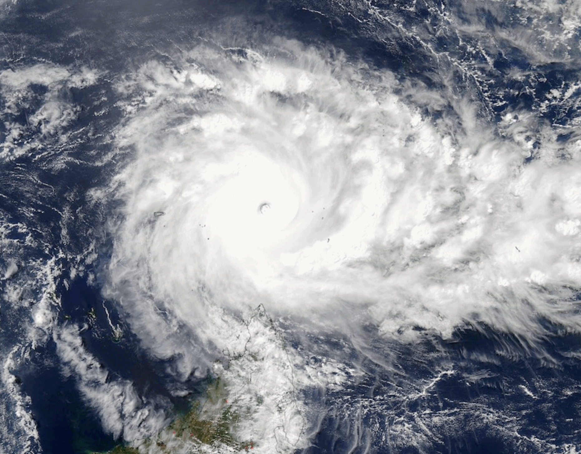
Image credit: "
A
visible image of Tropical Cyclone Fantala collected at 1025Z (6:25 am
EDT) on April 18, 2016, by the Moderate Resolution Imaging
Spectroradiometer (MODIS) sensor on board the Aqua satellite. The north
tip of Madagascar can be seen at bottom. At the time, Fantala was the
strongest tropical cyclone ever observed in the Indian Ocean, with winds
estimated at 175 mph." Image credit:
NASA.
Yes, Some Extreme Weather Can Be Blamed on Climate Change. The attribution signal is strongest with heat waves and extreme rainfall events, reports Scientific American: "Droughts,
wildfires, heat waves, intense rainstorms—these are all extreme weather
phenomena that occur naturally. But climate change is now increasing
the frequency and magnitude of many of these events. Flooding in Paris
and the Arctic heat wave are just two instances where climate change
contributed to extreme weather in 2016—and there are many more examples.
Yet how do scientists know that global warming influenced a specific
event? Until recently, they couldn’t answer this question, but the field
of “attribution science” has made immense progress in the last five
years. Researchers can now tell people how climate change impacts them,
and not 50 or 100 years from now—today. Scientific American spoke with
Friederike Otto, deputy director of the Environmental Change Institute
at the University of Oxford, about how attribution science works and why
it’s a critical part of helping communities prepare for and adapt to
climate change..."
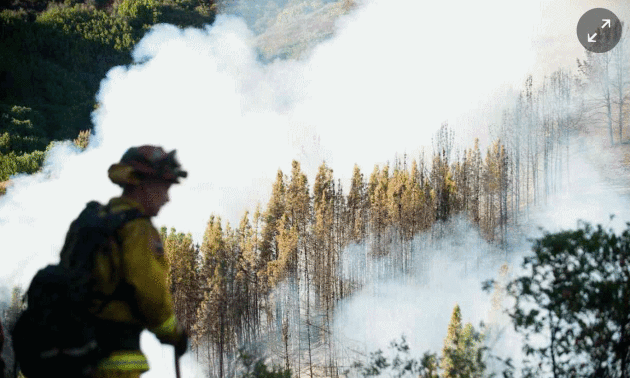
Climate Change in 2016: The Good, The Bad, an the Ugly. St. Thomas climate scientist John Abraham reports for The Guardian: "...The
best news of all, in my opinion, is the continued cost reductions and
huge installations of clean energy both in the US and around the word.
Wind, solar, and other renewables have been on an incredible run of decreasing costs
and creative financing, which has made them economically competitive
with dirty fossil fuels. Improvements and expansion of grid-based power
storage has also advanced. These storage abilities are needed to allow
intermittent power sources (like wind and solar) to play an even larger
role in delivering power to the grid. In the end, clean power will win
out based on simple dollars and cents – regardless of the fact they will
also help save the world..."
Photo credit: "
A
firefighter watches as smoke from a wildfire swirls around a stand of
trees near Morgan Hill, Calif., on Tuesday, Sept. 27, 2016. A heat wave
stifling drought-stricken California worsened the state’s wildfires in
2016." Photograph: Noah Berger/AP
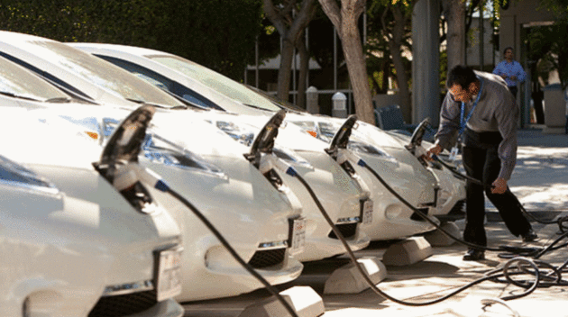
San Diego Among 5 Cities Leading Fight Against Climate Change. Times of San Diego has the story; here's an excerpt: "...With a population of nearly 1.4 million people, San Diego was the largest U.S. city in 2016 to have committed to producing all its energy from renewable sources.
The city, located in the drier southern part of California, has had to
introduce water cuts to combat prolonged drought in the state which has
been aggravated by climate change. San Diego’s mayor Kevin Faulconer
has committed some $130 million of a $3.4 billion budget for 2017 to
funding various projects to tackle climate change such as installing
solar panels to new bike lanes and energy-efficient street lights..."
Photo credit: "
Electric vehicles being charged in SanDiego." Photo courtesy SDG&E.
As World Warms, How Do We Decide When a Plant is Native? Here's an except from Yale Environment 360: "...Natural
range shifts of birds and other mobile species have been documented in
the past decade, but new studies suggest that many native plants are
also struggling to keep up with climate change by migrating to higher
elevations or towards the poles. In an analysis of the flora of Worcester County
in central Massachusetts in 2013, biologist Robert Bertin found that
the ranges of native plants appear to be contracting. “Northern” species
most widely distributed in upper New England, he wrote, are declining
faster than the region’s “southern” plants, primarily from New England’s
lower reaches, which are expanding their ranges northward. In a paper
published earlier this year, biologists detected significantly fewer
shifts in elevation by plants in California than by other organisms such
as birds and mammals..."
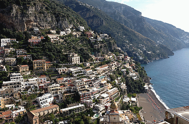
How Climate Change Threatens Famed Amalfi Coast. The Christian Science Monitor reports: "...Climate
change, blamed by experts and locals on global warming, has led to more
intense rainstorms in Italy, sometimes with devastating impact on
communities in this region south of Naples. “We are experiencing
rainfall that is much more intense – we are seeing torrential, almost
tropical, rain,” says Michele Buonomo of Legambiente, a national
environmental organization. “It has happened in the last 10 years – the
period in which we have seen the hottest temperatures globally for at
least two centuries,” says Mr. Buonomo, who is the president of
Legambiente in the region of Campania, which encompasses the Amalfi
Coast. “Italy has done very little over the years to respond to the
challenges of climate change. We need more action from the Italian
government. Spending is not keeping up with the increase in more extreme
weather events...”
Photo credit: "
A view of
Positano on Italy's Amalfi Coast. The region is famed for its scenery,
but the steep terrain is also vulnerable to mudslides.
" Alfredo Sosa.
Climate Change Highlights in 2016. Here's an excerpt from Huffington Post: "...May saw yet more records broken around the globe. In India, temperatures reached
an incredible 51 degrees Celsius (124 degrees Fahrenheit) in Rajasthan,
breaking the previous record high. Severe drought followed the extreme
heat ― at least 330 million people were without sufficient water. The
heat and drought compounded the misery for many people, especially in rural parts of the country,
who were already dealing with several years of below-average monsoons,
which are becoming more erratic because of climate change..."
Image credit:
Giphy.


No comments:
Post a Comment