Signs of Spring Down South
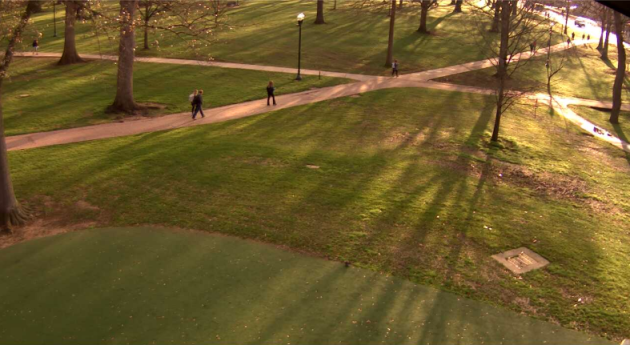
This was the view from the Univeristy of Mississippi in Oxford, MS early Wednesday. Note how green things are looking there! Spring seems to have already sprung! Temperatures will warm into the 60s and 70s here by the end of the week and weekend ahead. By the way, there are only 13 days left until the start of Meterological Spring (March 1st) and only 33 more days until the first official day of spring (vernal equinox on March 21st).
Start of Spring... Already?
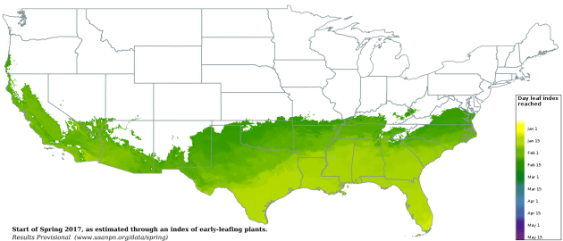
According to USA National Phenology Network, areas in the green color below show where spring has already sprung across parts of the Southern U.S.. Their definition of spring is this: The appearance of the first tiny leaves on the trees, or the first crocus plants peeping through the snow? "The Spring Leaf Index is a synthetic measure of these early season events in plants, based on recent temperature conditions. This model allows us to track the progression of spring onset across the country."
"The map below shows locations that have reached the requirements for the Spring Leaf Index model (based on NOAA National Centers for Environmental Prediction Real-Time Mesoscale Analysis temperature products)."
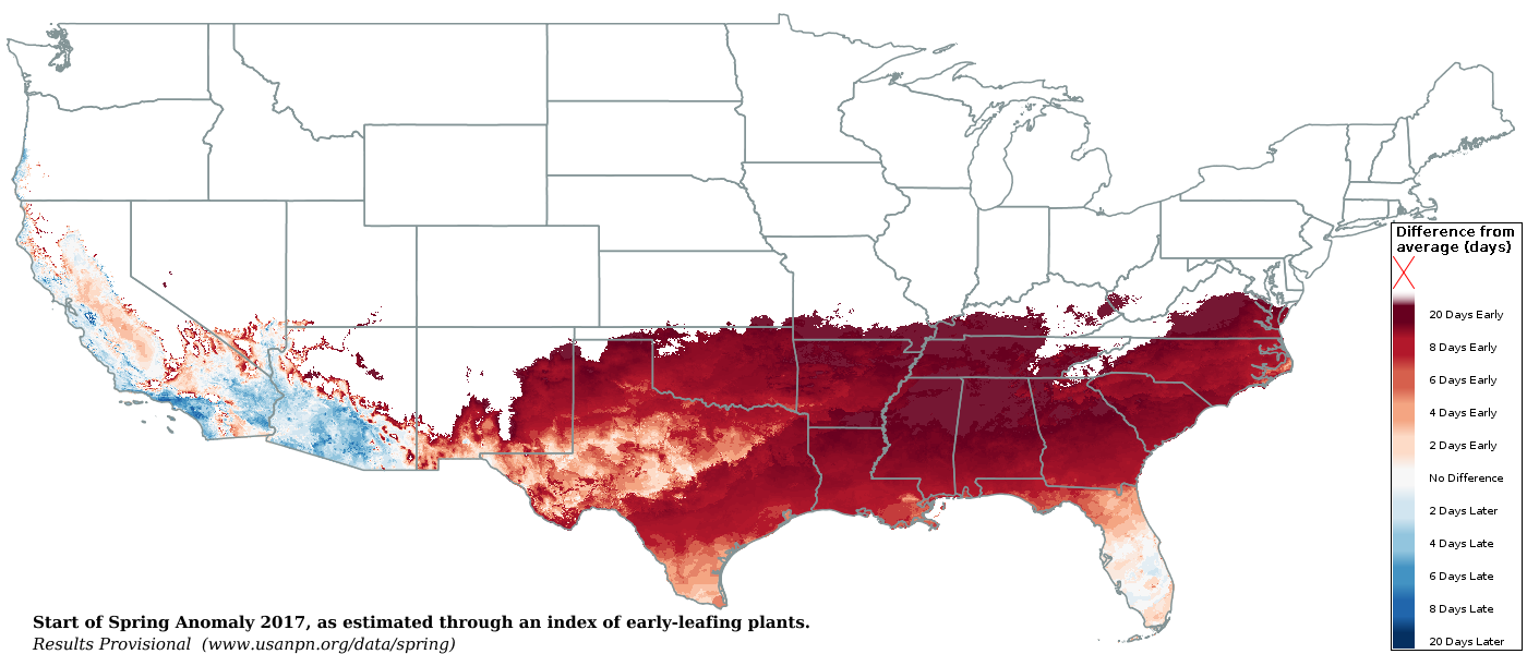
Start of Spring Anomaly 2017
Interestingly, spring has sprung 20+ days ahead of normal in some locations across the Southern U.S..
"We can evaluate whether spring is arriving early, late, or right on time this year at a location by comparing the day of year the Spring Leaf Index requirements were reached in 2017 to the day of year the Index is typically reached. We determine what is typical for a location by averaging the day the Index was reached over the 1981-2010 period. The number of days a between when the Index was reached this year and when it is typically reached at a location is called the “anomaly.”"
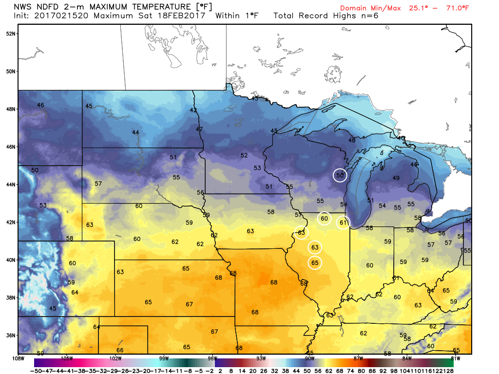
Record Warmth Ahead...
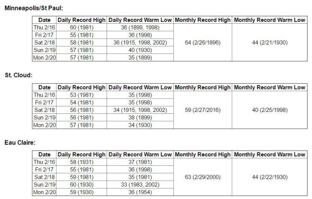
Thanks to the National Weather Service for the numbers below, which tell us how high the record highs are from 2/16 to 2/20 in Minneapolis, St. Cloud and in Eau Claire. Note that several of these records have a chance at being beaten in the days to come. If you're a fan of this warmer weather during meteorological winter, enjoy!
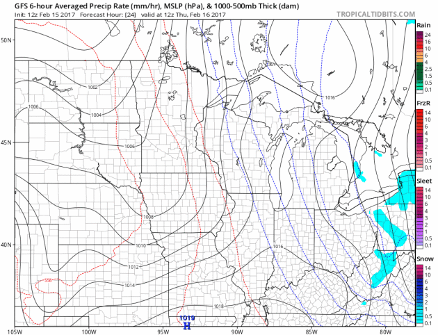
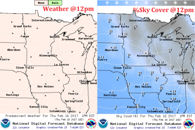
Weather Outlook for Through Early Next Week
Here's the weather outlook from Thursday to Monday. Note that we stay mostly dry all the way through the weekend. Our next best chance of precipitation doesn't arrive until Monday and at that point, temperatures look to be warm enough for February rain showers. Interestingly, weather models are hinting at a little instability, which would indicate the possibility of a few rumbles of thunder across parts of the Upper Midwest if this system stays together. Interestingly, the 30 year average for the Twin Cities suggests that February averages less than 1 day of thunderstorms (0.1 days) during the month.
______________________________________________________________________________
Mother Nature dialing up an early spring
By Todd Nelson, filling in for Douglas
By Todd Nelson, filling in for Douglas
According to the USA National Phenology Network, spring has already sprung across the southern tier of the nation. Defined as "the appearance of the first tiny leaves on the trees, or the first crocus plants peeping through the snow", the Spring Leaf Index model suggests that this is happening nearly 20+ days ahead of schedule this year! I can believe it!
March and April-like temperatures begin streaming into the region Thursday with highs in the 40s and 50s through early next week. Incredibly, some across southern Minnesota could reach 60 degrees on Friday! Record high temps will likely fall on Friday, but we have a chance at more record warmth through Monday.
While we bask in early spring-like weather, the West Coast will be inundated with another round of heavy Pacific moisture through early next week. Latest weather models suggest 6 to 9 inches of liquid possible for some locations, which may lead to additional flooding there. The deep California drought has been nearly completely wiped out and reservoirs continue to fill up!
___________________________________________________________________________
Extended Forecast:
WEDNESDAY NIGHT: Partly cloudy and quiet. Winds: ESE 5. Low: 24.
THURSDAY: Partly sunny and mild. Winds: SE 5. High: 43.
THURSDAY NIGHT: Mostly cloudy, nothing rough. Winds: SE 5. Low: 30.
FRIDAY: More sun. Record warm! Winds: SE 5. High: 58.
SATURDAY: Mostly sunn. More like April. Winds: WNW 5. Wake-up: 35. High: 52.
SUNDAY: Still very wawrm. Clouds thicken late. Winds: S 5-10. Wake-up: 33. High: 54.
MONDAY: February rain. Faint rumble of thunder? Winds: WSW 5-10. Wake-up: 42. High: 55.
TUESDAY: Mix of clouds and sun. Stray PM shower. Winds: E 5. Wake-up: 38. High: 47.
WEDNESDAY: Lingering sprinkles. Wet flakes north? Winds: NW 5-15. Wake-up: 36. High: 48
_______________________________________________________________________________
_______________________________________________________________________________
This Day in Weather History
February 16th
February 16th
1981: A significant warmup occurs across Minnesota. Highs in the 50s and 60s are common. 5 daily high records are broken in a row in the Twin Cities, with many others also broken statewide.
1903: A temperature of -59 is recorded at Pokegama Dam, tying the state record low at that time. It would not be broken for another 93 years.
_______________________________________________________________________________
_______________________________________________________________________________
Average High/Low for Minneapolis
February 16th
February 16th
Average High: 29F (Record: 60F set in 1981)
Average: Low: 13F (Record: -26F set in 1936)
Average: Low: 13F (Record: -26F set in 1936)
*Record Snowfall: 3.2" set in 1938
_______________________________________________________________________________
_______________________________________________________________________________
Sunrise Sunset Times For Minneapolis
February 16th
February 16th
Sunrise: 7:11am
Sunset: 5:43pm
Sunset: 5:43pm
*Daylight Gained Since Yesterday: ~2 minutes & 56 seconds
*Daylight Gained Since Winter Solstice (December 21st): ~1 hour & 45 minutes
________________________________________________________________________________
*Daylight Gained Since Winter Solstice (December 21st): ~1 hour & 45 minutes
________________________________________________________________________________
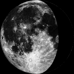
Moon Phase for February 15th at Midnight
2.5 Days Before Last Quarter
2.5 Days Before Last Quarter
________________________________________________________________________________
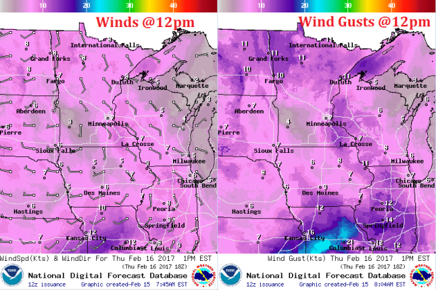
Weather Outlook For Thursday
Temperatures really begin to warm across the Upper Midwest as we head into the end of the week. Note that temperatures across southwestern Minnesota look to warm into the 50s, which the Twin Cities looks to warm into the 40s, which will be nearly 20 degrees above average!
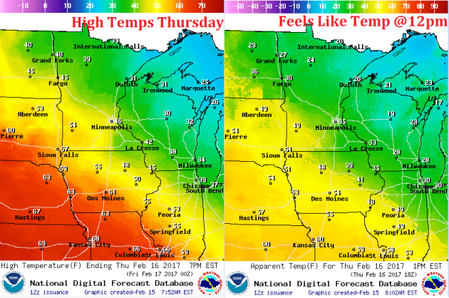
Weather Outlook For Thursday
Note that winds will be out of a more southerly direction on Thursday. This will help warm temperatures and keep temperatures at well above average levels over the next several days.
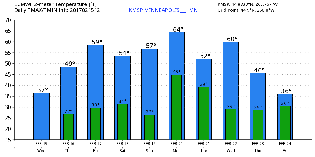
Here's the temperature outlook through February 24th, which shows well above average temperatures continuing through the weekend and into early next week. Note that we could see our first 50F in the Twin Cities since November 28th (55F) and we may even see our first 60F in the Twin Cities since November 16th (61F). This weekend is going to feel very much like April with highs in the 50s to near 60 degrees! Unreal!
___________________________________________________________________________________
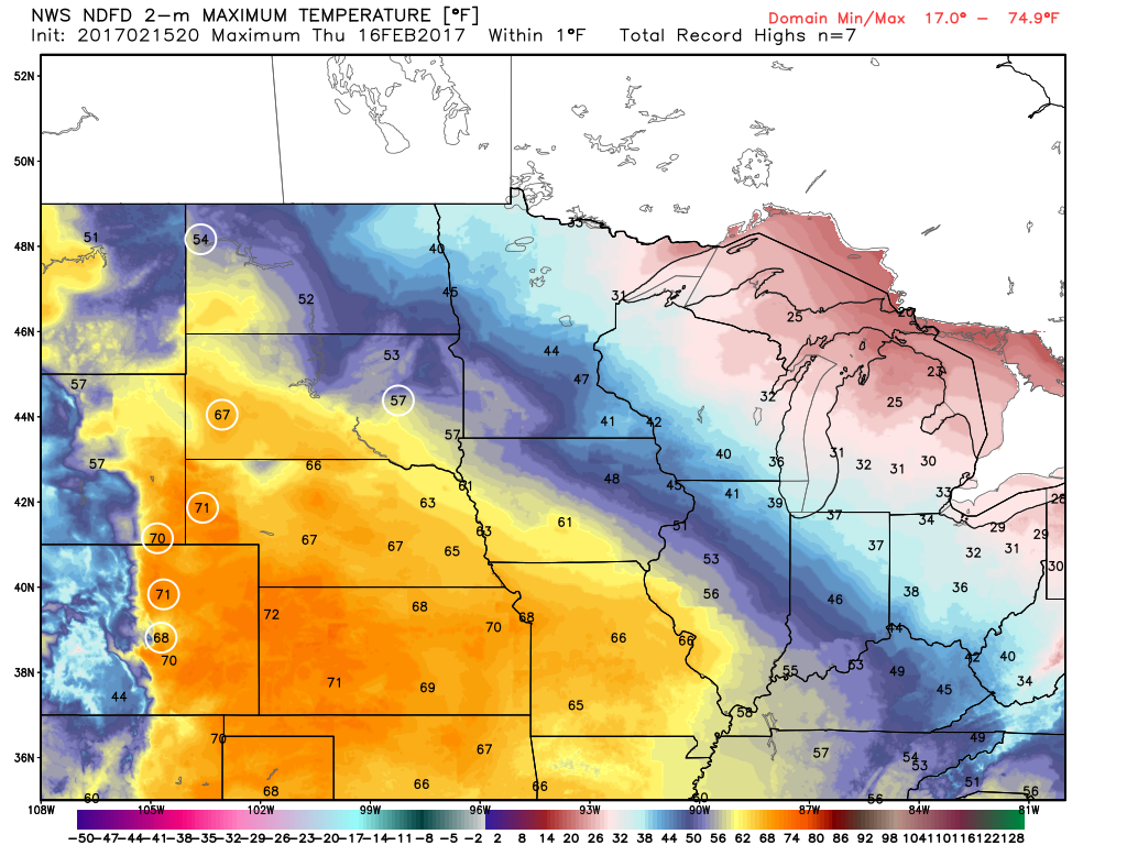
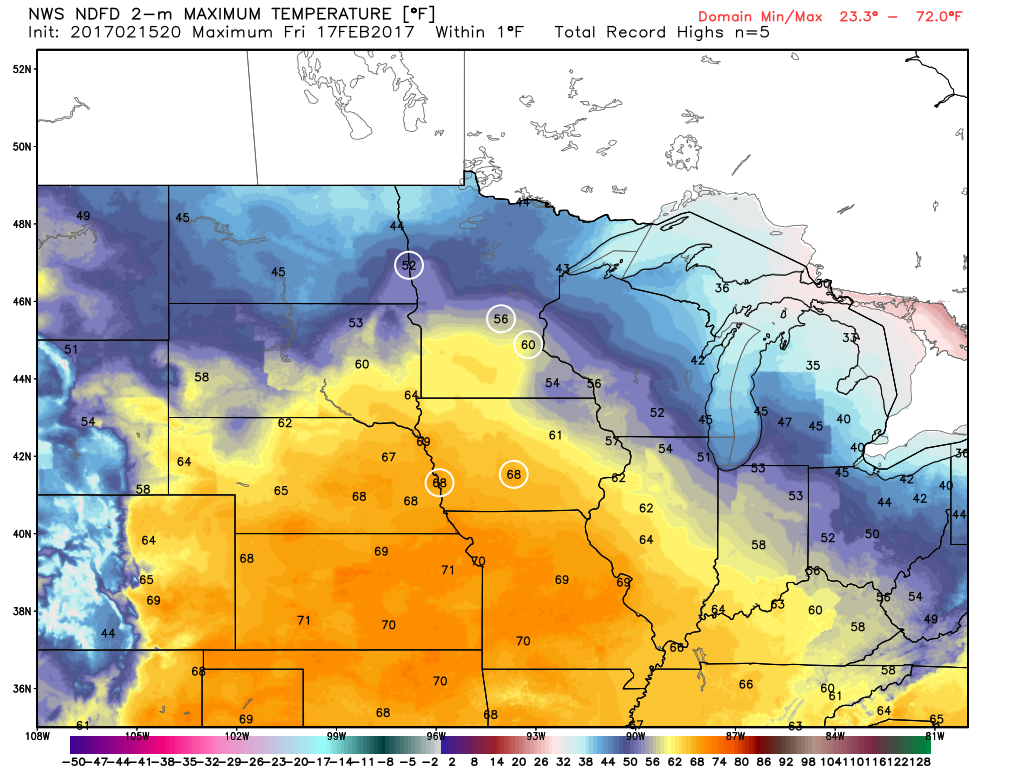
Record Warmth Later This Week
As temperatures warm later this week, record warmth could follow. The images below show where record warmth is forecast (circles) for Thursday, Friday, Saturday and Sunday . Note that by Friday, record warmth could stretch as far north as Minneapolis, MN, St. Cloud, MN, and Fargo, ND!
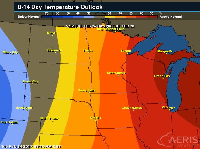
8 to 14 Day Temperature Outlook
According to NOAA's CPC, the 8 to 14 day temperature outlook suggests warmer than average temperatures continuing across much of the Upper Midwest from February 24th - 28th. There may be a slight cool down late month, but the overall trend remains warmer than average.
_________________________________________________________________________________
Temperature Outlook
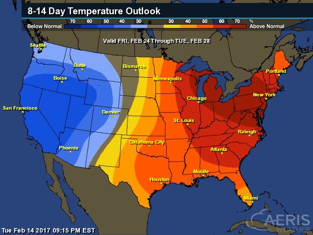
National Temp Outlook
Take a look at the temperature anomaly through Saturday, February 25th. Note that the despite a quick shot of cooler than average temps by the middle and end of this week, the eastern half of the country looks to stay warmer than average through much of that time period. Colder than average temps begin moving into the western part of the country next week and perhaps into the central part of the country by the last weekend of the month.
 ________________________________________________________________________________
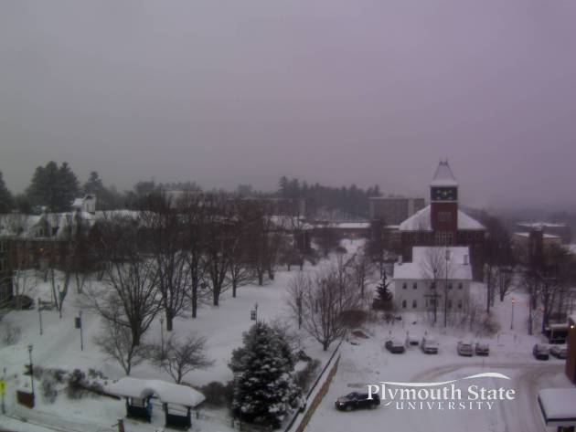
Heavy Snow Tapers in the Northeast Early Thursday
February has been a VERY snowy month for parts of the Northeast and the New England States. Here's the view from Plymouth State University located in Plymouth, NH, which showed snowy conditions once again on Wednesday. This storm may drop up to 12" in spots across the Northeast before wrapping up on Thursday.
Simulated Radar Thursday - Friday
The latest snow storm in the Northeast will quickly wind down on Thursday with only lingering light snow showers and or flurries continuing into early Friday morning.

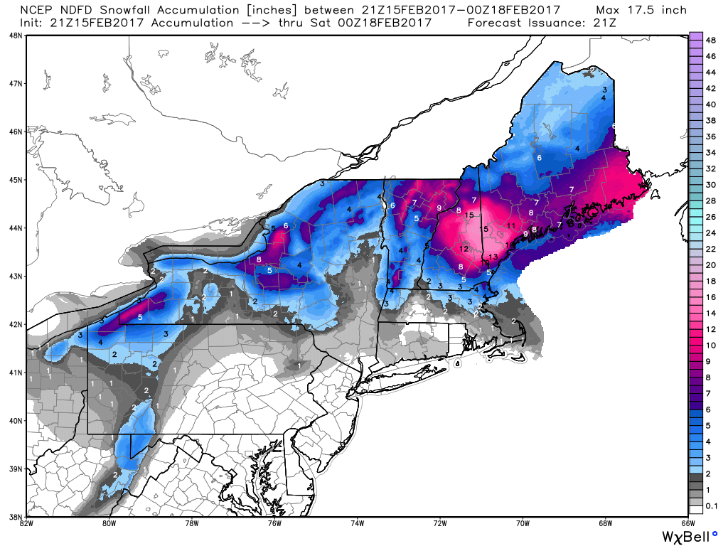
Here's the total snowfall potential through PM Friday, which shows pockets of heavy snowfall across parts of the northern New England states as well as parts of the Eastern Great Lakes. Some of the heaviest tallies here could reach 12"+ by the end of the week.
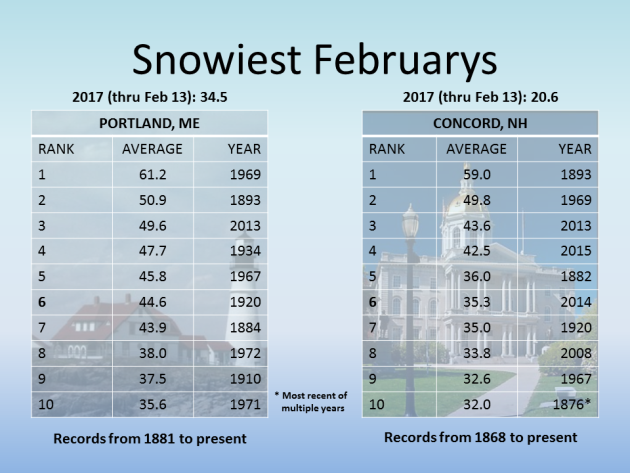
Heavy February Snows
Thanks to the National Weather Service out of Gray, ME for the numbers below, which show some of the snowiest February's on record for Portland, ME and Concord, NH. Note that Portland, ME has seen 34.5" of snow thru February 13th and with this next event, they could be in the top 10!
_____________________________________________________________________
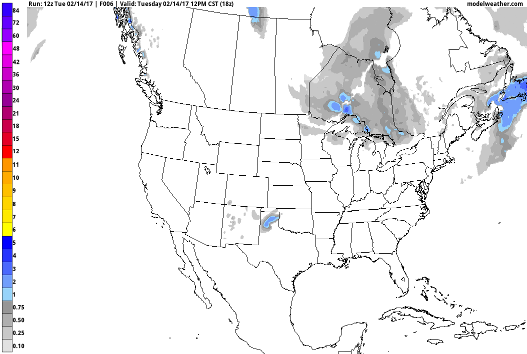
Radar Estimated Precipitation Past 30 Days
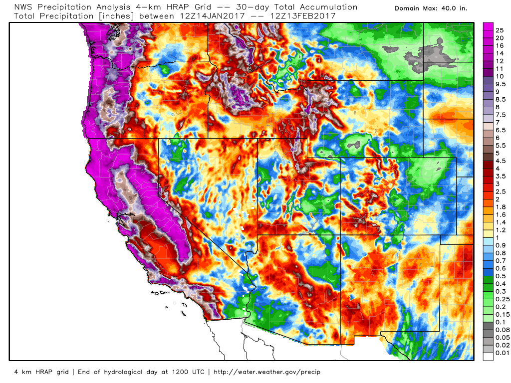
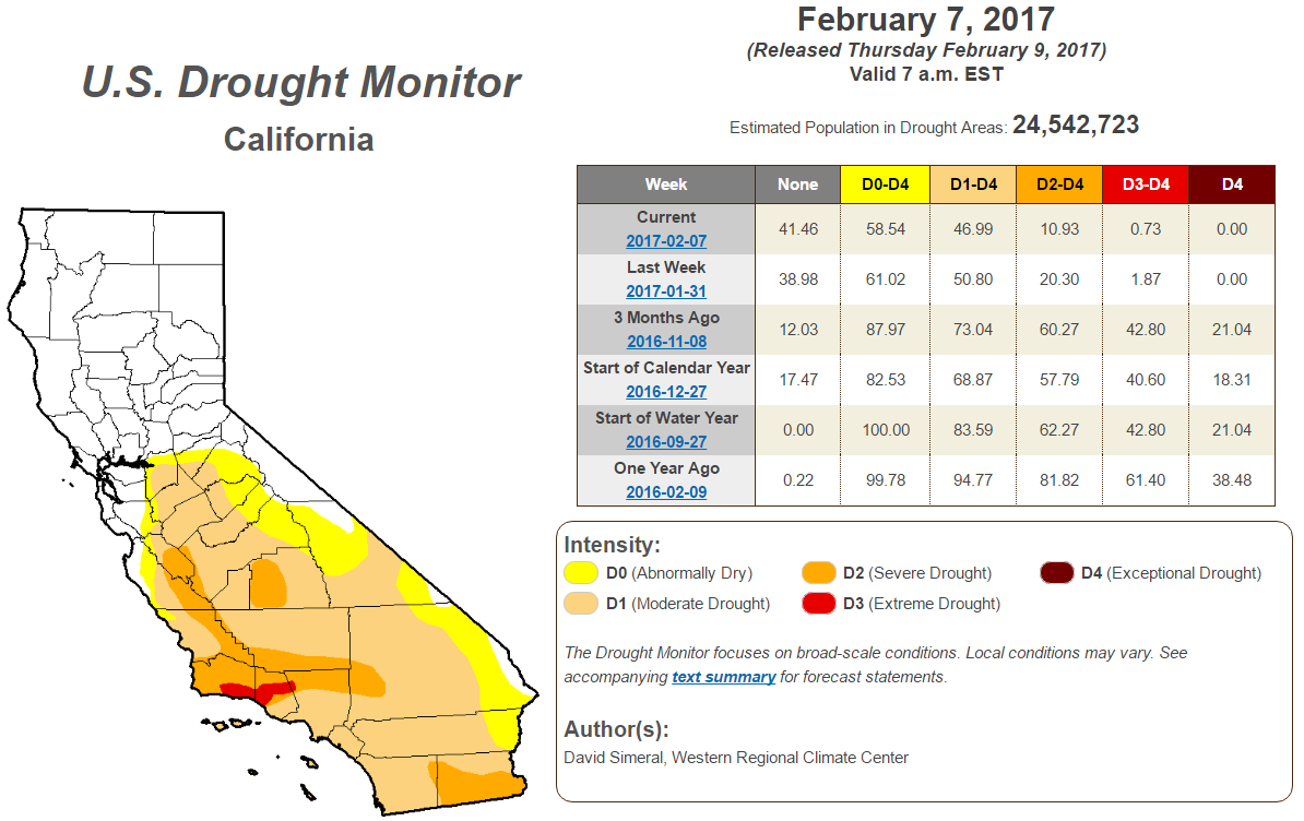
Improving California Drought
According to the U.S. Drought Monitor, the California drought continues to improve. Note that over the last 3 months, we have seen major improvement in the Exceptional, Extreme and Severe drought. With the additional moisture expected this week, we should continue to see even more improvement!
Atmospheric Rivers Continue...
Heavy precipitation has been falling across the Western U.S. due to rivers of Pacific moisture plowing into the region. Note the deep plumes of Pacific moisture that seems to be directed right toward the West Coast, these are the Atmospheric Rivers that are responsible for the extensive precipitation. Note the next big plume setting up just west of the region, this will be responsible for another heavy surge through the week ahead.
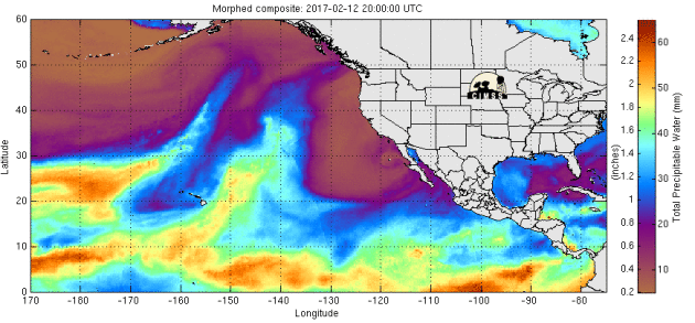
Several rounds of heavy precipitation have blasted the West Coast and we're not quite done yet. Another surge of heavy precipitation will push through the region this week and weekend ahead with more possible into early next week with significant rainfall and flooding along with heavy mountain snow.
.gif)
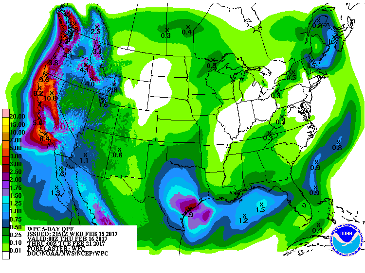
5 Day Precipitation Forecast
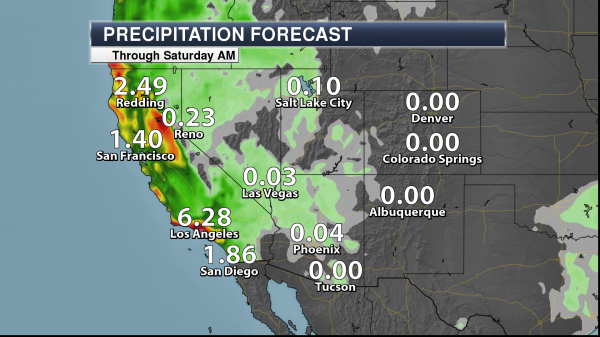
More Heavy Rains in California
Here's a closer look at how much rain could fall around Los Angeles, CA and across parts of the Southwest through AM Saturday. Note that some spots near Los Angeles, CA could see nearly 6" or more, which could lead to flooding.
.png)
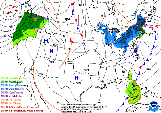
National Weather Outlook
Here's the national weather outlook through the end of the week, which shows another round of snow pushing through the Great Lakes and the Northeast, while strong to severe storms continue across the southeastern. Meanwhile, another surge of Pacific moisture looks to begin moving into the West Coast. This next surge of Pacific moisture will continue sliding down the coast and will likely bring parts of southern California heavy precipitation as well.
 Snowfall Potential
Here's the snowfall potential into early next week, which shows heavy mountain snow developing once again across parts of the Western U.S.. Heavy looks to develop once again across the Cascades, Sierra Nevada Range in and across the Rockies.
_________________________________________________________________________________
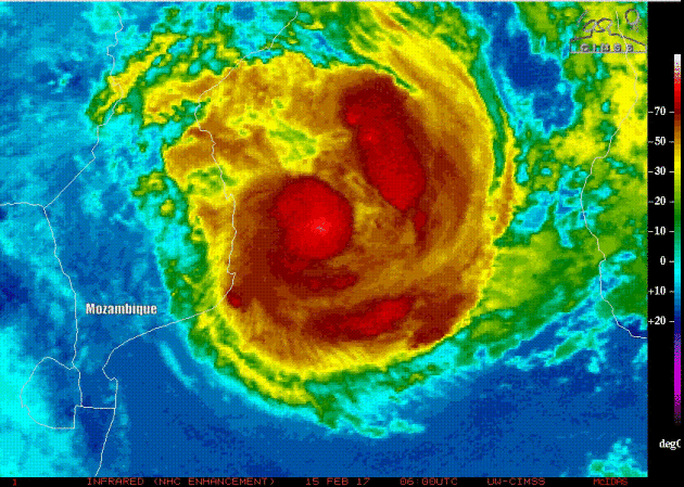
Cyclone Dineo
While the Atlantic and Pacific Ocean basins remain quiet close to home, Cylone Dineo is making headlines in Southwestern part of the Indian Ocean. This was the view of Dineo as it neared Inhambane, Mozambique in southeastern Africa.
___________________________________________________________________
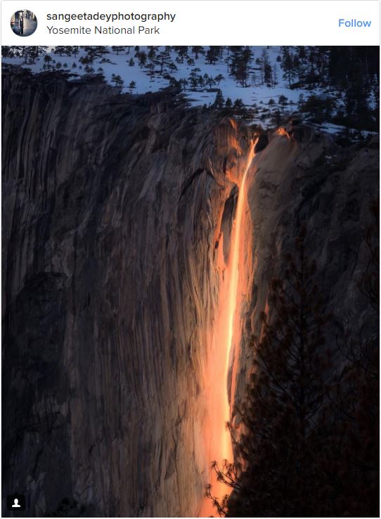
"Firefall wows visitors at California’s Yosemite National Park"
"The "firefall" phenomenon at California’s Yosemite National Park is back. In mid-February each year, the sun hits the Horsetail Fall at just the right angle to create an illusion that looks like lava flowing off the side of the cliff instead of water. The firefall only lasts for a few minutes at sunset, and draws hundreds of visitors hoping to capture an out-of-this-world shot."
See more from USAToday.com HERE:
(Image credit: sangeetadeyphotograph via Instagram)
_________________________________________________________________________
See more from USAToday.com HERE:
(Image credit: sangeetadeyphotograph via Instagram)
_________________________________________________________________________
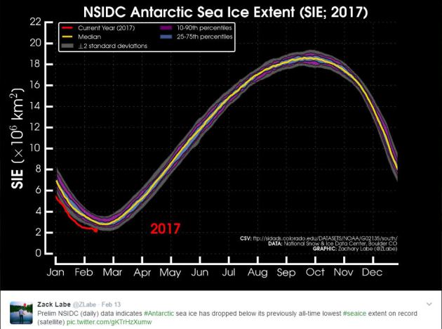
"Sea Ice Hits Record Lows at Both Poles"
"Arctic temperatures have finally started to cool off after yet another winter heat wave stunted sea ice growth over the weekend. The repeated bouts of warm weather this season have stunned even seasoned polar researchers, and could push the Arctic to a record low winter peak for the third year in a row. Meanwhile, Antarctic sea ice set an all-time record low on Monday in a dramatic reversal from the record highs of recent years."
"Climate threat to wildlife may have been massively underreported"
"More than 700 of the world’s threatened and endangered animal species may be directly affected by climate change, according to a new study — vastly more than the number of animal species scientists initially thought would face risks from global warming. Scientists had previously determined that only 7 percent of mammals and 4 percent of birds on the International Union for Conservation of Nature (IUCN) “Red List” of threatened species are affected by climate change. However, a new study finds that the threat from climate change may have been massively underreported."
"Species like the mountain gorilla are especially threatened by climate change because of their very limited, specific habitat."(LIANA JOSEPH/WILDLIFE CONSERVATION SOCIETY)

_________________________________________________________________________
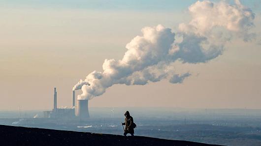
"Humans are changing climate 170 times faster than nature, say researchers"
"Over the past 7,000 years the primary forces driving change have been astronomical - changes in solar intensity and subtle changes in orbital parameters, along with a few volcanoes," Will Steffen, of the Fenner School of Environment and Society and the Climate Change Institute at ANU, said in a statement. "Human-caused greenhouse gas emissions over the past 45 years have increased the rate of temperature rise to 1.7 degrees Celsius per century, dwarfing the natural background rate," Steffen added."
(Lukas Schulze | Getty Images)
______________________________________________________________________________
Thanks for checking in and don't forget to follow me on Twitter @TNelsonWX

No comments:
Post a Comment