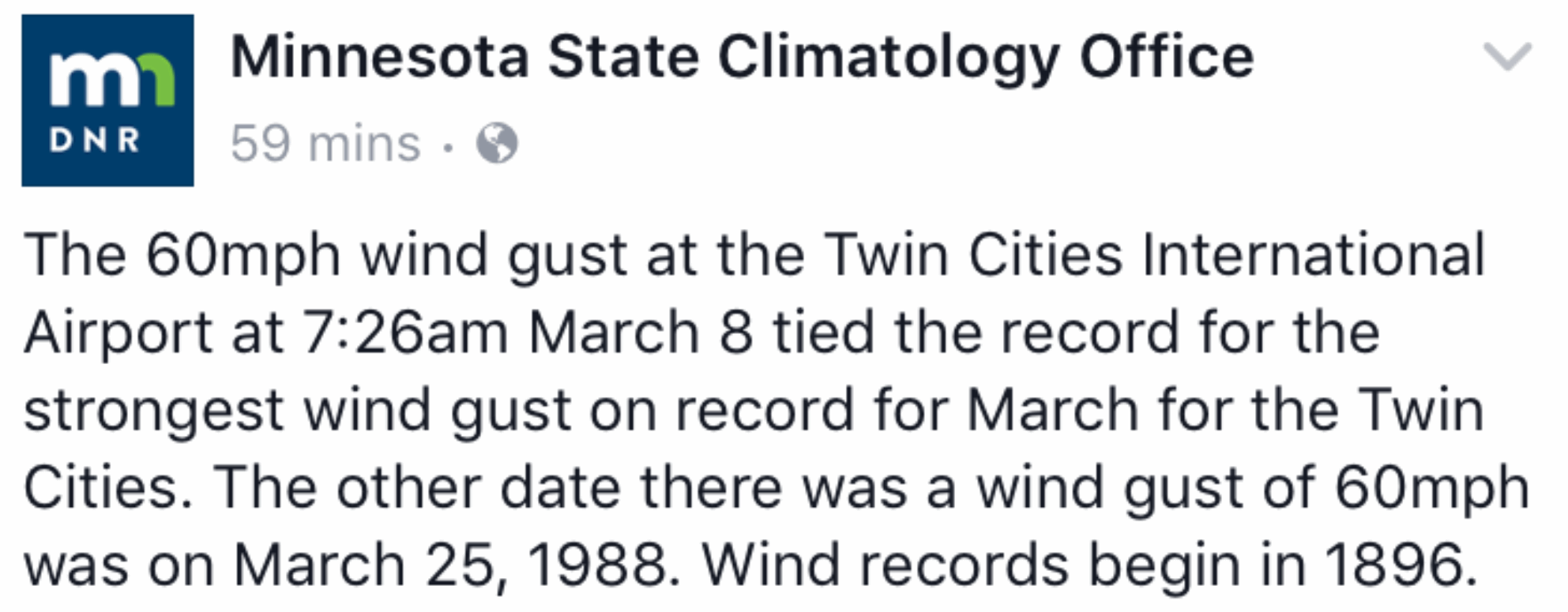
60 mph peak wind gust in the Twin Cities Wednesday.
25.5 mph average wind speed yesterday.
36 F. high yesterday in the Twin Cities.
37 F. average high on March 8.
70 F. high on March 8, 2016.
March 9, 1918: A snowstorm hits Minnesota and dumps nearly 11 inches at the Twin Cities.
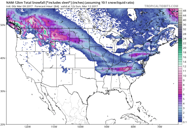
Winter's Last Gasp Tonight Into Sunday? Probably
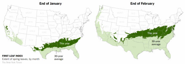
Just for the record, you won't be mowing the lawn anytime soon. Yes, many lakes are experiencing the earliest ice-out on record. Birds are chirping, spring break so close you can taste it. But keep your (weather) expectations low.
It seems like Tropical Storm Flo has stalled out over Minnesota with wind gusts over 60 mph yesterday; a tip-off of what's coming: from shorts & tornadoes on Monday to subzero wind chills just 4 days later.
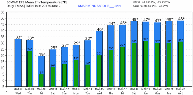
The same blistering airmass that set record lows from Alaska into the Yukon will brush Minnesota tonight into the weekend. In spite of a higher sun angle temperatures struggle to reach 20F Friday; readings 10-15F colder than average into early next week. Dig out the coats one more time.
A Sunday clipper may leave behind a cosmetic snowfall, even an inch or two of slush - a friendly reminder that winter won't go away willingly. Every year it's a struggle. 40s return late next week; the latter half of March dominated by a mild, Pacific wind flow.
A Minnesota spring is always 2 steps forward, one big step back. Sadly 2017 will be no exception.
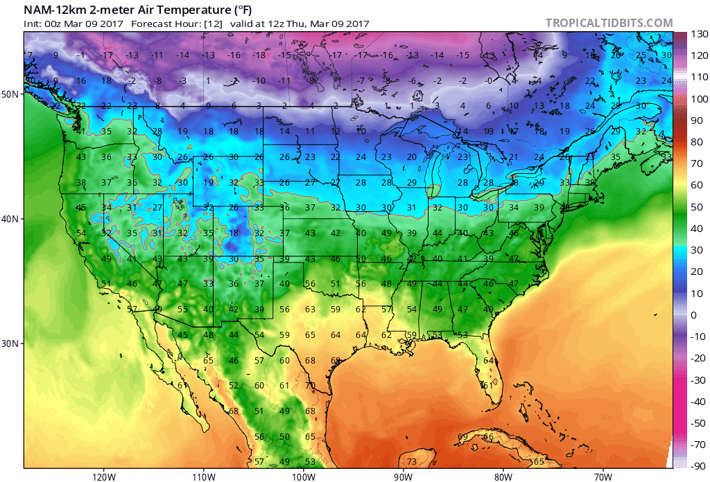
2-meter temperature forecast for the next 84 hours. NOAA NAM model and Tropicaltidbits.com.
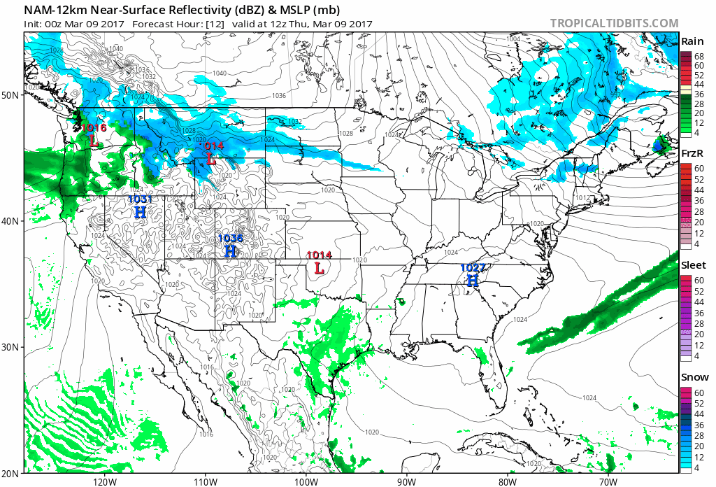
Minor Canadian Invasion. The same airmass that set records from Alaska into western Canada will brush the northern USA in the coming days, the core of this numbing air aimed at New England, where weekend temperatures may be 20-25 F. colder than average for mid-march. Stormy weather continues with heavy rain and mountain snows from the Pacific Northwest into the Northern Rockies. A series of Alberta Clippers puts down a few snowy streaks across the Plains and Midwest into Sunday.

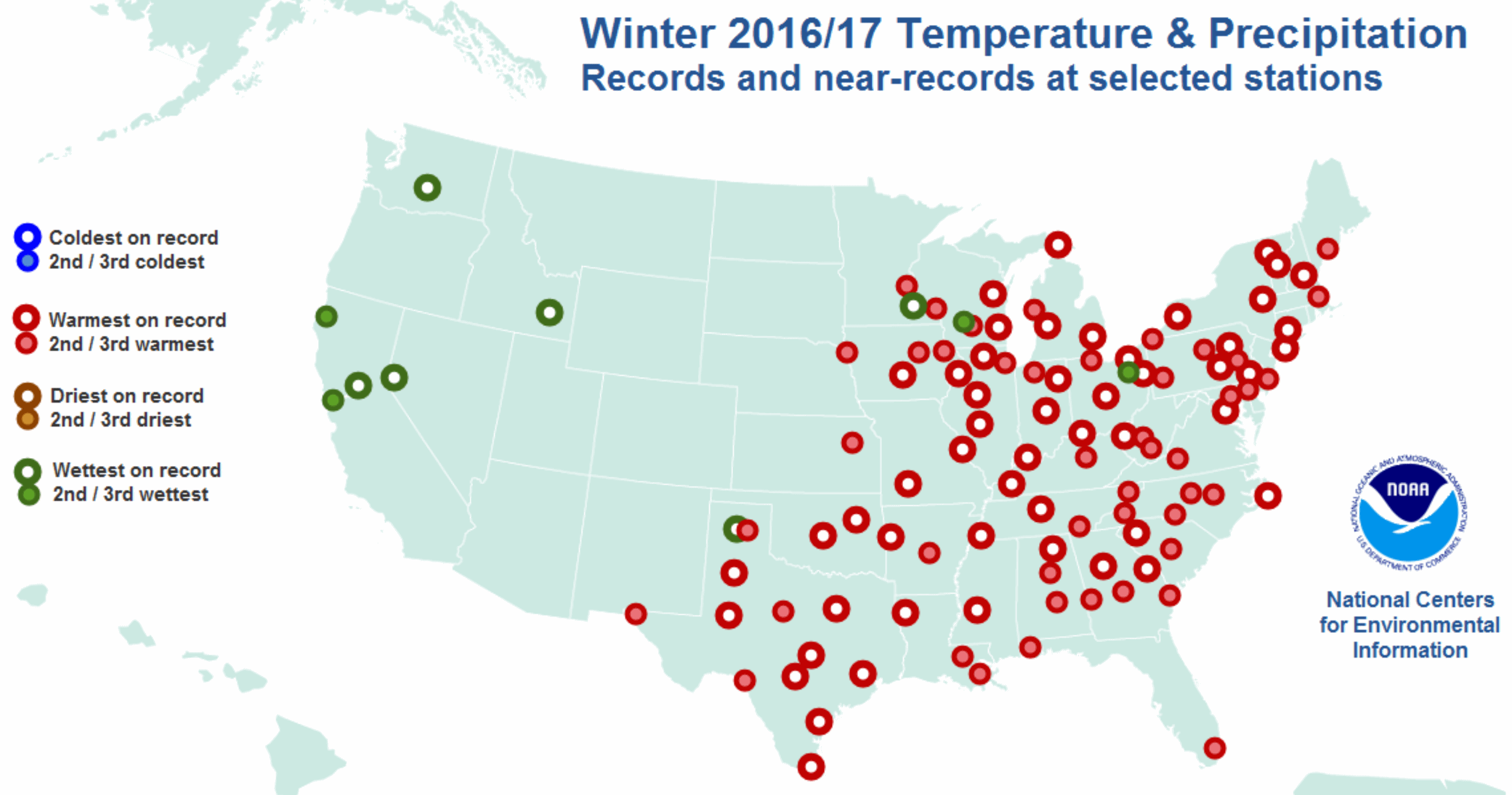
Record Warmth for Meteorological Winter. Yes, it was a top 3 warmest December though February for muh of America east of the Rockies. Here's an excerpt from NOAA NCEI: "The stations shown on the map below had one of their three warmest, coolest, wettest or driest winters on record this year. Stations with a bold white circle saw values that exceed any previous December-through-February value at the station's current location. The smaller circles indicate year-to-date outcomes that were 2nd or 3rd place among a station's history..."
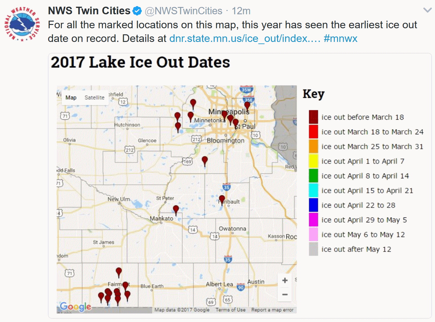

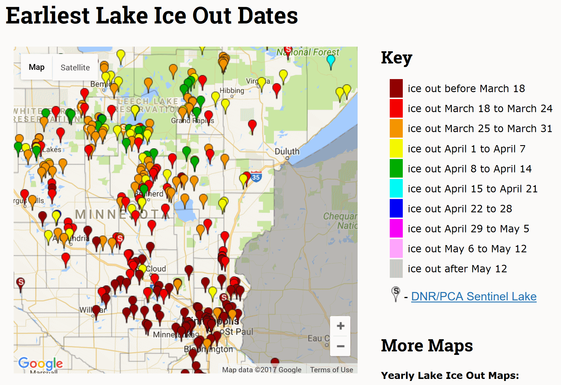
Earliest Ice-Outs on Minnesota Lakes. Ice out on Lake Calhoun already? That's nearly a month ahead of schedule. Check out the stats on your favorite lake at the Minnesota DNR.
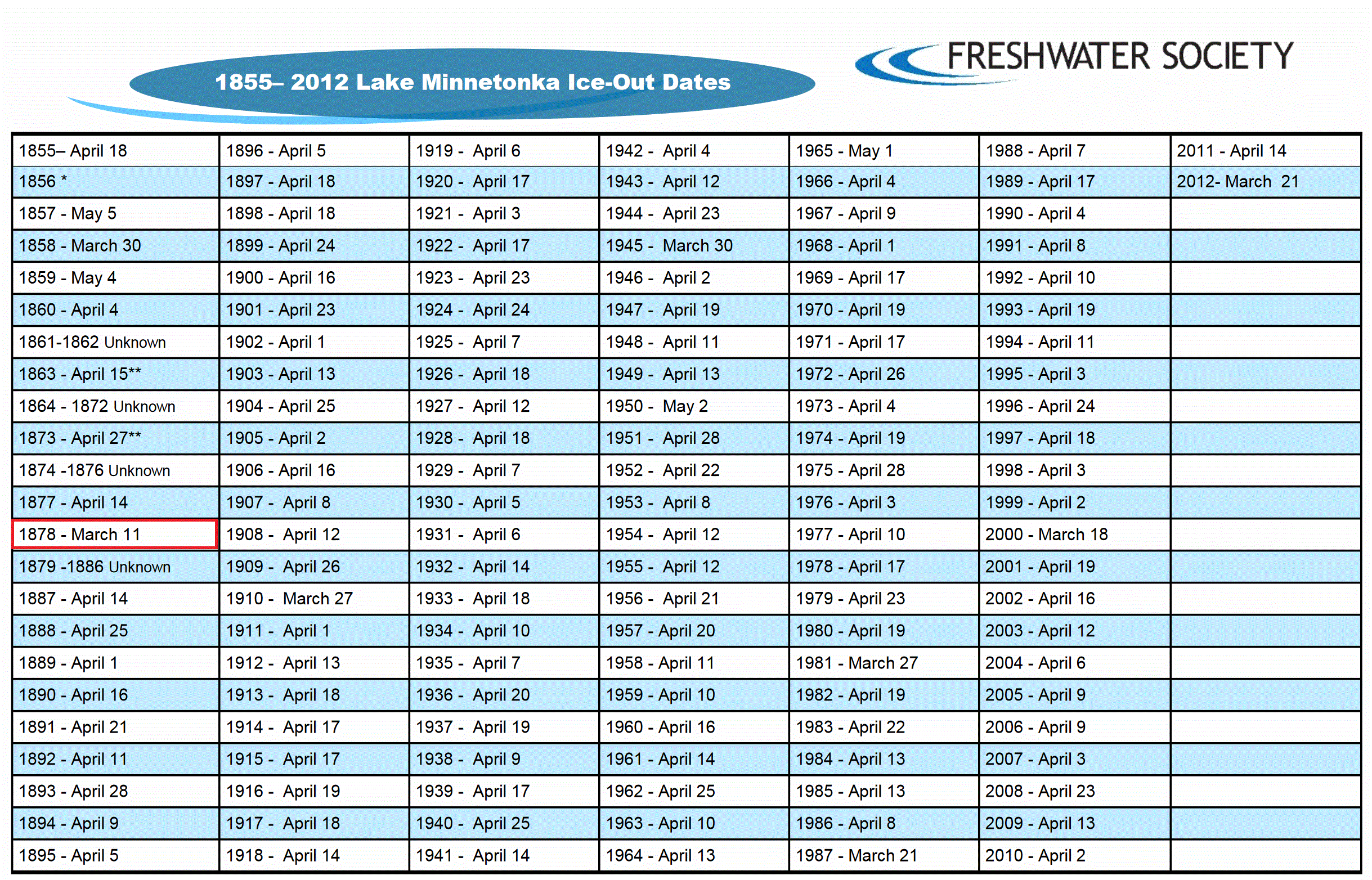
Earliest Ice-Out On Record for Lake Minnetonka? If the ice comes off before March 11 we may have a new record on 'Tonka. Data courtesy of The Freshwater Society.
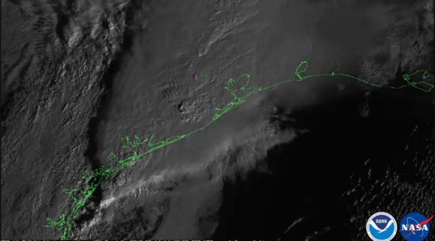
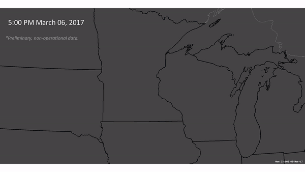 Earliest Known Tornado in Minnesota History. The previous record is March 18, 1968. We broke the record by nearly 2 weeks. Here's an excerpt from the Twin Cities National Weather Service: "On
March 06, 2017, an early spring severe weather outbreak produced large
hail and damaging wind in Wisconsin, and even tornadoes across
Minnesota. This marks the earliest date in Minnesota history that a
tornado was ever recorded. The previous record was March 18, 1968. The
loop to the right shows a comparison of visible and infrared satellite
imagery from the GOES16 satellite, along with radar reflectivity,
lightning, and warnings at 5:00 PM March 06, 2017. The line of
thunderstorms was located across Central Minnesota and extends southward
into Iowa..."
Earliest Known Tornado in Minnesota History. The previous record is March 18, 1968. We broke the record by nearly 2 weeks. Here's an excerpt from the Twin Cities National Weather Service: "On
March 06, 2017, an early spring severe weather outbreak produced large
hail and damaging wind in Wisconsin, and even tornadoes across
Minnesota. This marks the earliest date in Minnesota history that a
tornado was ever recorded. The previous record was March 18, 1968. The
loop to the right shows a comparison of visible and infrared satellite
imagery from the GOES16 satellite, along with radar reflectivity,
lightning, and warnings at 5:00 PM March 06, 2017. The line of
thunderstorms was located across Central Minnesota and extends southward
into Iowa..."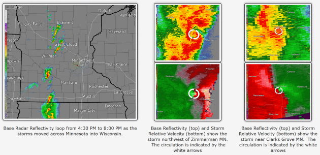
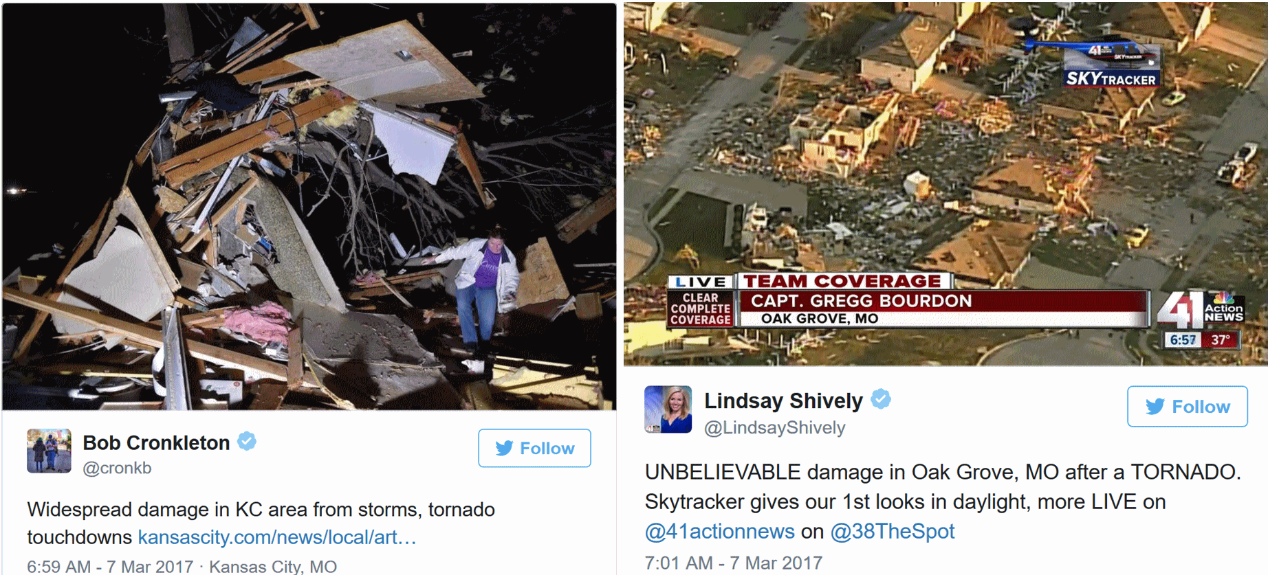
Hundreds of Homes Damaged as Storms, Tornadoes Batter Midwest. Here's an excerpt of a good overview from USA TODAY: "...A severe storm system pummeled parts of the Midwest overnight with tornadoes, huge hailstones and powerful winds, damaging nearly 500 buildings and injuring a dozen people in one Missouri city. The Storm Prediction Center in Norman, Okla., received reports of more than 30 tornadoes in Kansas, Missouri, Iowa and Illinois late Monday and early Tuesday. Powerful winds extended as far south as the Ozark Mountains in Arkansas, where a post office and church were damaged, and as far north as Wisconsin, where trees were downed. In Oak Grove, Mo., 483 homes sustained some type of damage, along with 10 to 12 commercial buildings, said Sni Valley Fire Protection District Chief Carl Scarborough..."
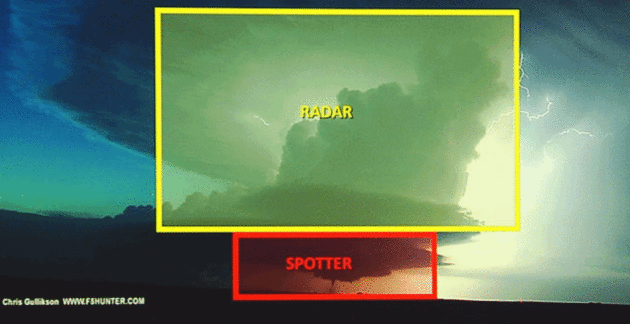
Image credit: WKRN; Image: Chris Gullikson.
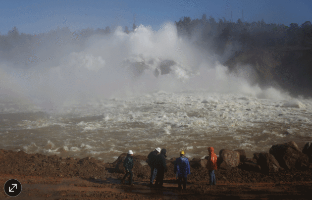
Photo credit: "Water being released from Lake Oroville Dam on Feb. 14. Enough water has spilled out of the rain-swollen California lake to meet the demands of roughly 14 million people for a year." Photo: jim urquhart/Reuters.
Climate Scientists and Weather Forecasters Outraged by Proposed Cuts to NOAA. Jason Samenow reports at Capital Weather Gang: "...NOAA, which is part of the Department of Commerce, houses the National Weather Service and the divisions responsible for weather satellites and atmospheric research. The weather satellite division, known as the National Environmental Satellite, Data and Information Service, would be hardest hit by the proposed cuts. The administration proposes slashing its budget by $513 million in the 2018 fiscal year, which starts Oct. 1. Data from weather satellites are indispensable for models used to predict the weather. NOAA has conducted experiments that show that forecasts for costly and deadly storms would be far less accurate without such information..."
Image credit: "Visualizations of Hurricane Sandy in 2012." (Mel Shapiro, NCAR).
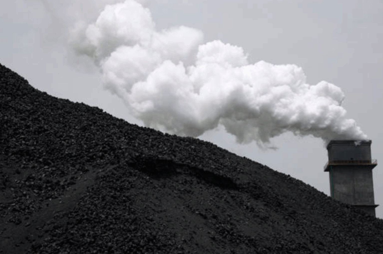
8 Fossil Fuel Majors Seen Polluting as Much as U.S. Bloomberg has the story: "Eight of the world’s largest oil companies are responsible for as much of the climate-damaging pollution spewed into the atmosphere as the entire U.S., according to a study by a London-based researcher. Saudi Aramco, Exxon Mobil Corp., OAO Gazprom, the National Iranian Oil Co., BP Plc and Royal Dutch Shell Plc were among the eight companies whose fuel was responsible for a third of emissions from oil and gas, according to the non-profit group CDP. The companies released a fifth of all greenhouse gases outside of farming and forestry since 1988, the year most governments acknowledged man-made climate change as a risk..."
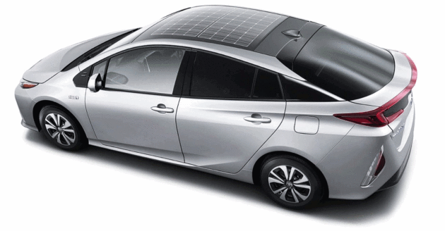
Will Electric Cars Soon Have Solar Roofs? Toyota and Tesla Say Yes. Driving for free - what a concept. Here's an excerpt from ThinkProgress: "Last week, Panasonic announced
an advanced solar panel system that will debut on the 2017 model Toyota
Prius plug-in hybrid in Japan (the Prius Prime). It is “the first
commercially available, mass-produced passenger car to feature an
optional solar charging system,” PV magazine explained.
Panasonic notes that, previously, rooftop solar cells had outputs of
only “several tens of watts.” So they were used only for ventilating
parked cars and “auxiliary charging” of the standard 12-Volt lead-acid
battery. But improvements in solar efficiency combined with advanced
design and “technologies to laminate three-dimensional curved glass”
have allowed a high output — some 180 watts, which is more than triple
the output of the previous solar roof..."
Image credit: Panasonic via NewAtlas.com.
Don't Roll Back the Vehicle Fuel Standards. Here's an excerpt of an Op-Ed at The New York Times: "...Weakening
these standards would be a mistake for consumers, the environment and
the auto industry itself. They are the most important action the United
States has taken to address climate change
and reduce the nation’s dependence on oil. From 2022-25 alone, they are
projected to reduce American oil consumption by 1.2 billion barrels,
cut half a billion metric tons of carbon pollution and save consumers
millions of dollars in fuel costs, according to the Environmental Protection Agency.
The net benefits to society are estimated at $100 billion. And these
gains are on top of those achieved through 2016 and expected through
2021..."

Bentley's First-Ever, Electric Concept Car is a Luxury Fever Dream. BloombergPursuits has more details: "Although most of the notable debuts at the Geneva Motor Show are teased months ahead of
time, Bentley came out swinging on Tuesday with a surprise showing of
the marque's first-ever, pure-electric concept. The Bentley EXP 12 Speed
6e Concept is meant to explore the possibility of Bentley producing a
true all-electric vehicle for production; it’s a separate endeavor from
the recently promised plug-in hybrid Bentayga SUV, which is due out in
2018. If it is received well by VIP guests and analysts at future car
circuit stops in Shanghai and Pebble Beach, Calif., said execs, the
convertible could lead to an electric vehicle from Bentley by 2021. (The
car, while drivable, is one of one, so in order to prevent damage it
will not be available for prospective buyers to drive.)..."

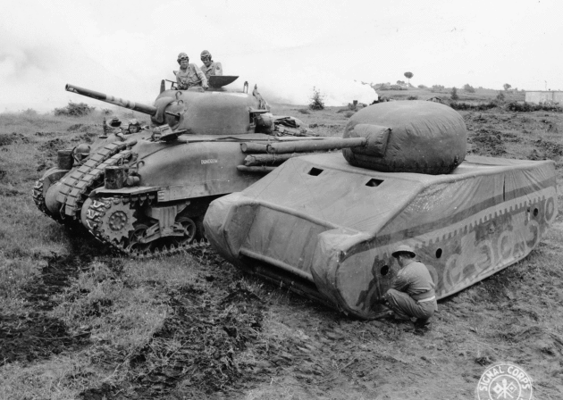
Fake Armies? Visual Guide to Fake Fleets and Inflatable Armies of WWII. Here's a clip from Atlas Obscura: "The
image above depicts a clever trick played on battlefields during World
War II: Bobbing next to a sturdy metal tank is a rubber inflatable copy
meant to fool enemies. An army could look twice as large as it
was thanks to elite divisions of the military that specialized in the
art of decoys and deception. Military units within both the Allied and
Axis forces practiced and deployed an assortment of peculiar, yet
effective tactics, from building inflated dummy tanks to constructing
wooden artillery and straw airplanes. A fleet of dummy tanks could lead
an enemy to overestimate a force’s actual strength or draw an attack
away from a vulnerable area, explained Gordon Rottman in World War II Tactical Camouflage Techniques..."
Photo credit: "From afar, this British dummy tank would be easily fooled for the real tank it stands next to." NARA/111-SC-216202-001
“God loves each one of us as if there were only one of us to love.” - Augustine
TODAY: Early flakes, colder. Winds: N 8-13. High: 33
THURSDAY NIGHT: Clearing and very cold, subzero wind chills late. Low: 7
FRIDAY: Comfortably numb with blue sky. Feels like -8 F. early. Winds: N 8-13. High: 21
SATURDAY: Clouds linger, colder than average. Winds: N 5-10. Wake-up: 6. High: 25
SUNDAY: Clipper potential. Light accumulation? Winds: NE 7-12. Wake-up: 14. High: 28
MONDAY: Flurries taper, slow clearing. Winds: N 10-15. Wake-up: 19. High: 29
TUESDAY: Sunny, feeling better about March. Winds: SW 8-13. Wake-up: 10. High: 33
WEDNESDAY: Gray, freezing drizzle early? Winds: SE 5-10. Wake-up: 18. High: 38
Climate Stories....
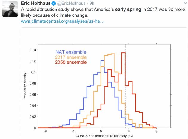
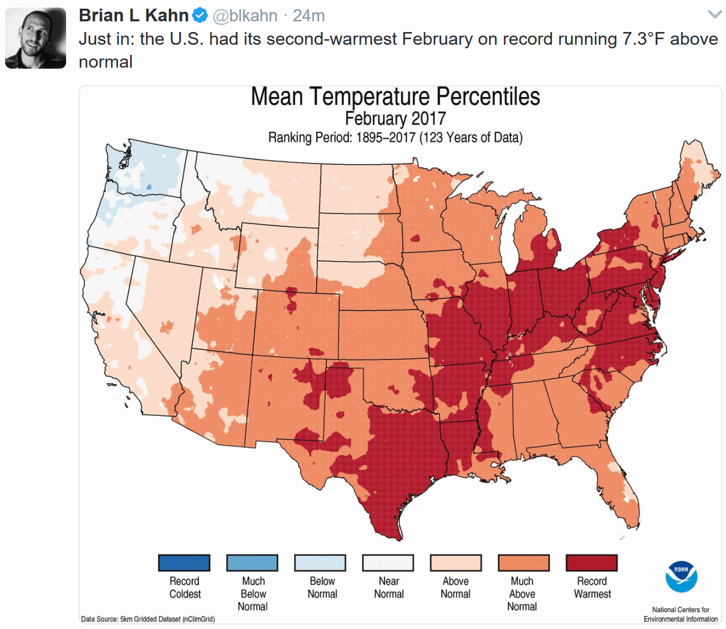
Spring Came Early. Scientists Say Climate Change is a Culprit. Here's an excerpt of a New York Times analysis: "...The
new research shows a strong link between global warming and the very
warm February that helped to drive the extremely early spring this year.
For the entire continental United States, February 2017 was the second
warmest on record, and mean temperatures were especially high east of
the Rockies: as much as 11 degrees Fahrenheit above normal. The study,
by scientists working as part of a group called World Weather Attribution,
looked at the influence of climate change on the temperatures, using
models of the atmosphere as it exists and of a hypothetical atmosphere
with no greenhouse gas emissions and thus no human-driven climate
change. They found that a warm February like the one just experienced is
about four times more likely in the current climate than it would have
been in 1900, before significant emissions began to change the climate..."
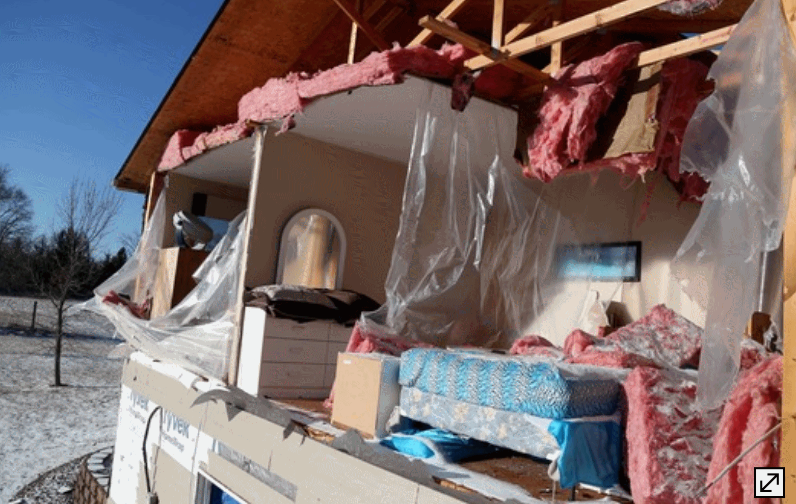
A Tornado in Early March? In Minnesota? Really? Republican Tim Reckmeyer makes a convincing case for bipartisan action in this Op-Ed at Star Tribune; here's an excerpt: "...In
colder climates, like ours, winter-based recreational activities, like
skiing, ice fishing, and snowmobiling are less prevalent. This has
effects on local businesses and kids who just want to play pond hockey
throughout winter. The frequency of Lyme disease in Minnesota is
increasing because more disease-carrying insects, like ticks, survive
milder winters. Allergy season is already 21 days longer than it was in
1995, and pollen counts are rising, which can trigger respiratory
illnesses for allergy sufferers. This can have deadly implications for
children and the elderly. The most important actions we can take are to
support smart pro-growth economic policies that reduce our energy waste
and fully embrace clean energy to power our modern world. Doing so will
stabilize our climate and winters, reduce the risks of further damage to
our economy, and immediately provide better health via cleaner air and
water..."
Photo credit: David Joles, Star Tribune. "The entire side of a house was blown off during a storm Monday evening in Orrock Township near Zimmerman, Minn."
Study: Climate Change May Hurt Nation's Agricultural Productivity. Here's an excerpt from Iowa Public Radio: "...They
found that without changes to farm policy and improvements to
agricultural technology, the nation’s productivity in 2050 could look
like it did in 1980. That’s because at the present rates of innovation,
new technologies won’t be able to keep up with the damage caused by the
changes in climate in our major growing regions. Lead author Xin-Zhong
Liang, a professor at the University of Maryland, says both policymakers
and those who work directly in agriculture should consider changes that
might prevent this drop. On the policy side, Liang said, changes to
water management could help. On the technology side, the development of
seeds that can withstand more extremes of heat and rain would likely
help mitigate the climate’s impact on overall productivity..."
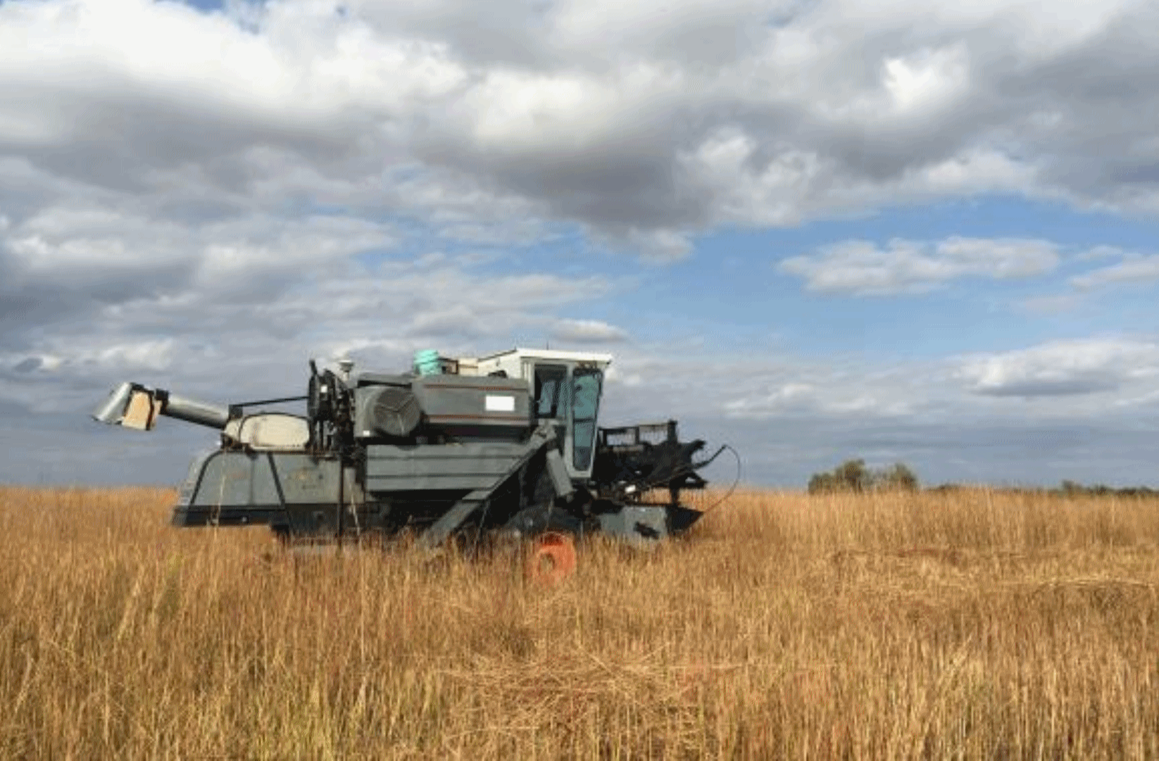
Photo credit: "Farming
in the Midwest could suffer under future climatic conditions. A new
study says if the threats aren't addressed, future US food production
could be lower than necessary to meet global demand." Harvest Public Media file photo.
ConocoPhillips CEO Says U.S. Should Stick With Paris Climate Deal. Axios has the details.

Trees Might Not Be Able to Store as Much Carbon As We Thought, New Study Suggests. An article at CNBC highlights new research raising concerns that soil nutrients may not be sufficient for plants to process increasing CO2 efficiently: "Researchers at Western Sydney University (WSU) in Australia have found that "common" Australian trees do not store as much carbon as had been previously assumed, a discovery that could have big implications on how we tackle climate change. According to a news release from the university, the study, published in the journal Nature Climate Change, found that Eucalyptus forests may require extra soil nutrients to grow and "take advantage" of additional carbon dioxide (CO2) in the atmosphere. Large areas of "remnant native eucalypt forest" were exposed to heightened levels of CO2 at a WSU facility. Researchers found that while the extra CO2 increased levels of photosynthesis, it did not result in increases in leaves, stems and wood..."
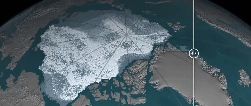
Arctic Sea Ice May Vanish Even If World Achieves Climate Goal: Study. Here's a story excerpt from Reuters: "Arctic sea ice may vanish in summers this century even if governments achieve a core target for limiting global warming set by almost 200 nations in 2015, scientists said on Monday. Arctic sea ice has been shrinking steadily in recent decades, damaging the livelihoods of indigenous peoples and wildlife such as polar bears while opening the region to more shipping and oil and gas exploration. Under the 2015 Paris Agreement, governments set a goal of limiting the rise in average world temperatures to well below 2 degrees Celsius (3.6 Fahrenheit) above pre-industrial times, with an aspiration of just 1.5C (2.7F). "The 2 degrees Celsius target may be insufficient to prevent an ice-free Arctic," James Screen and Daniel Williamson of Exeter University in Britain wrote in the journal Nature Climate Change after a statistical review of ice projections..."
Image credit: Difference in September ice from 1984 to 2016. NOAA and NASA.
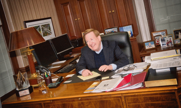
The Republican Mayor is Bucking his Party to Stand Up for Climate Action. ThinkProgress has the story: "...That’s
because to six-term mayor and lifelong Republican Jim Brainard, making
his city more sustainable — and reducing Carmel’s contribution to
climate change — isn’t a liberal issue. It’s an issue that speaks to his
vision of conservatism, and he deeply believes more Republican leaders
should start speaking up about climate change as well. “I somewhat
regret not speaking out sooner,” he told ThinkProgress. “There’s a lot
of Republicans out there that think like I do. They have been
intimidated, to some extent, by the Tea Party and the conservative talk
show hosts. But at a certain age, you just don’t care. You think, ‘I’m
going to say what I think and what I think is best for my constituents.’
If you do that, I think it comes through to the voters...”
Photo credit: "Mayor Jim Brainard in his office in Carmel, Indiana." CREDIT: Tom Britt
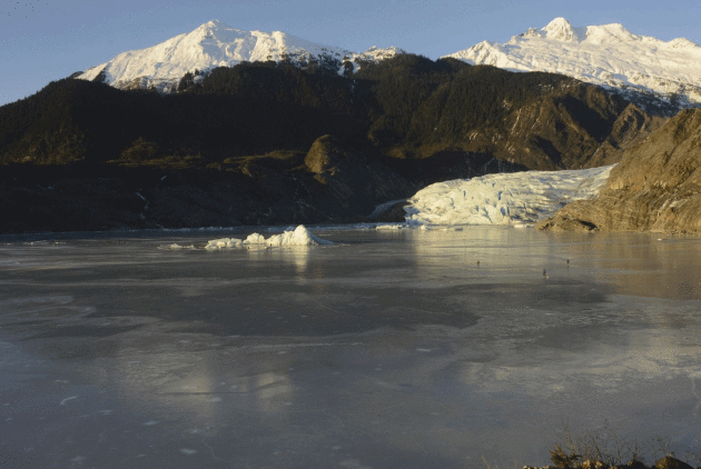
James Balog on Climate Change: "It's a Tragedy That It's Been Politicized". Here's an excerpt of a story at Sarasota's Herald-Tribune: "...We
have lived in a fairly narrow zone of temperature and moisture for the
last 10,000 years," Balog said. "To ignore (climate change), we're
basically gambling in our world." Although climate change
has been a controversial topic politically, Balog rejected those who
view it as a partisan topic. Instead, he said climate change is simply
an objective fact regardless of political party. "It's a tragedy that the issue has been politicized," Balog said. "It never should've been turned into political football." At that statement, nearly the entire audience began to applaud..."
Photo credit: "The Mendenhall Glacier in Alaska was photographed by James Balog in 2015 for the Extreme Ice Survey project." Ccurtesy: James Balog.
No comments:
Post a Comment