.8" snow fell yesterday at Twin Cities International Airport.
37 F. maximum temperature yesterday.
34 F. average high on March 1.
27 F. high temperature in the cities on March 1, 2016.
March 2, 1913: A record low of 24 degrees below zero is set at the St. Cloud Regional Airport.
 Another Early Spring Brings Back Memories of 2012
The
decorative, cosmetic splashes of snow in your yard are in grave peril.
Snap a photo soon, because another warm front is coming. This winter,
when in doubt, predict a warm front. Odds are you'll be right.
Then
again, data shows February was the 18th month/row of warmer than
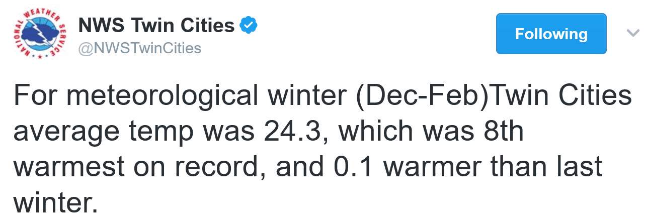
average temperatures, according to the Minnesota DNR. NOAA reports that
meteorological winter was the 8th warmest on record.
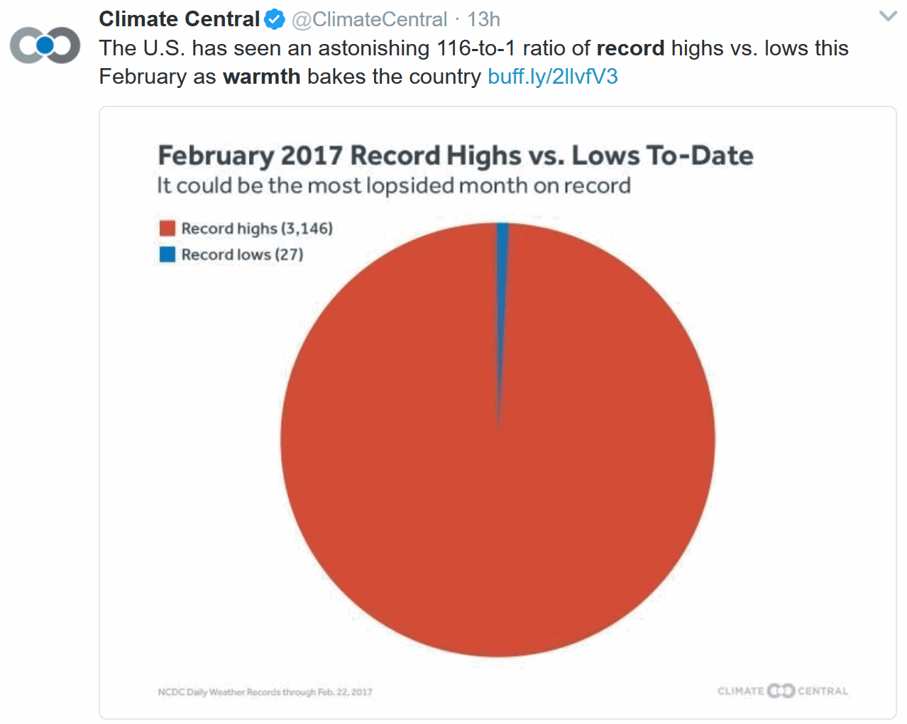
Nationwide
there were 3,146 record highs and 27 record lows last month. Chicago had
no snow on the ground in January and February. Spring is in full bloom
south of a line from Kansas City to Indianapolis and Pittsburgh.
Yes,
odds favor an early ice-out and at the rate we're going we may see
flowers blooming within a month, much like we saw in 2012.
Today
and Friday will be cooler than average but a weekend thaw is on tap.
ECMWF (European) guidance hints at 60F Sunday & Monday. Another warm
front surges north late next week and T-storms may pop up 1 week from
today.
It's hard not to cheer on these amazing early springs - until you realize the planet is running a low-grade fever.
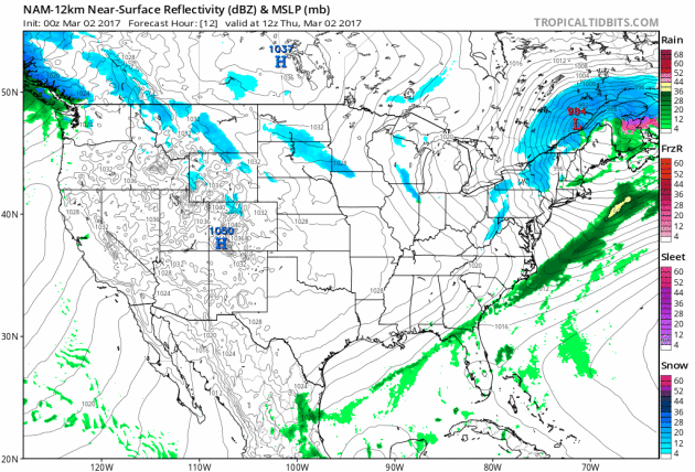
Relatively Quiet Thursday.
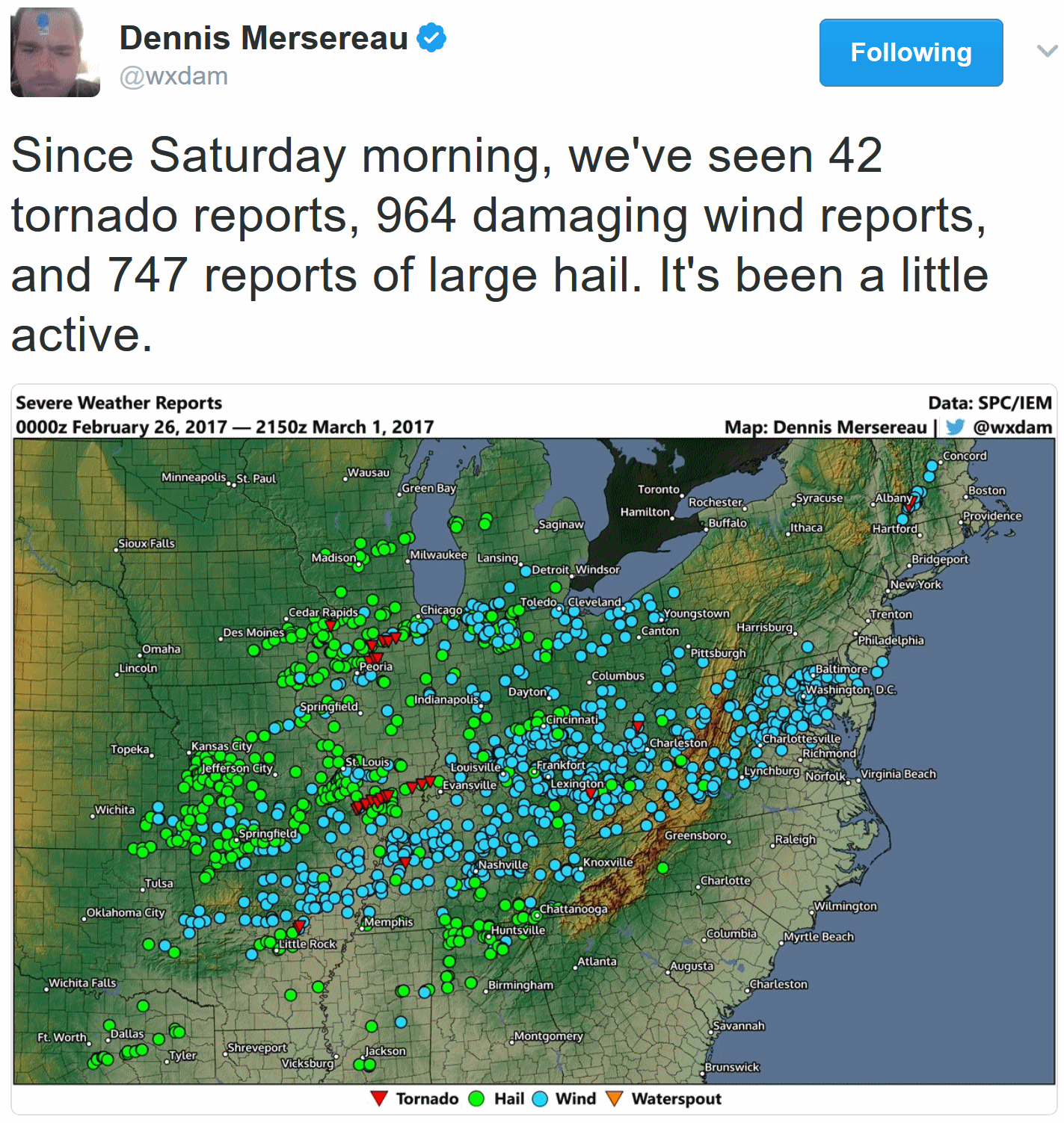
After recent episodes of severe weather from the Mid South and Ohio
Valley to the East Coast and widespread flooding for California and the
western USA it's nice to have a (brief) breather today. Showers and
T-storms push across Florida as a cooler bubble of high pressure pushes
into the southeastern USA. More heavy rain and snow spreads into the
Pacific Northwest; another surge of heavy rain forecast to reach
northern California by Saturday night. 84-hour NAM forecast: NOAA and
Tropicaltidbits.com.
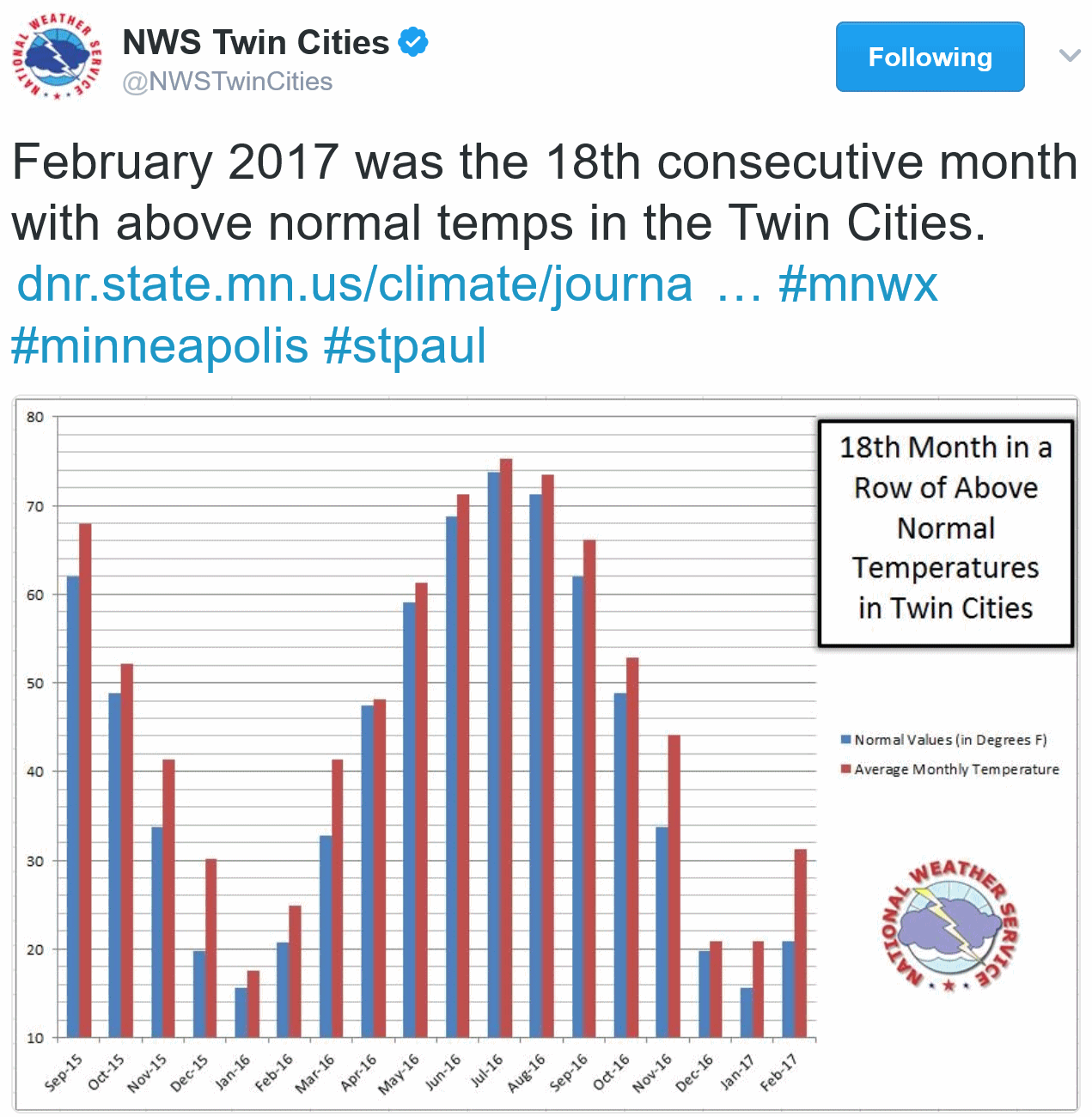
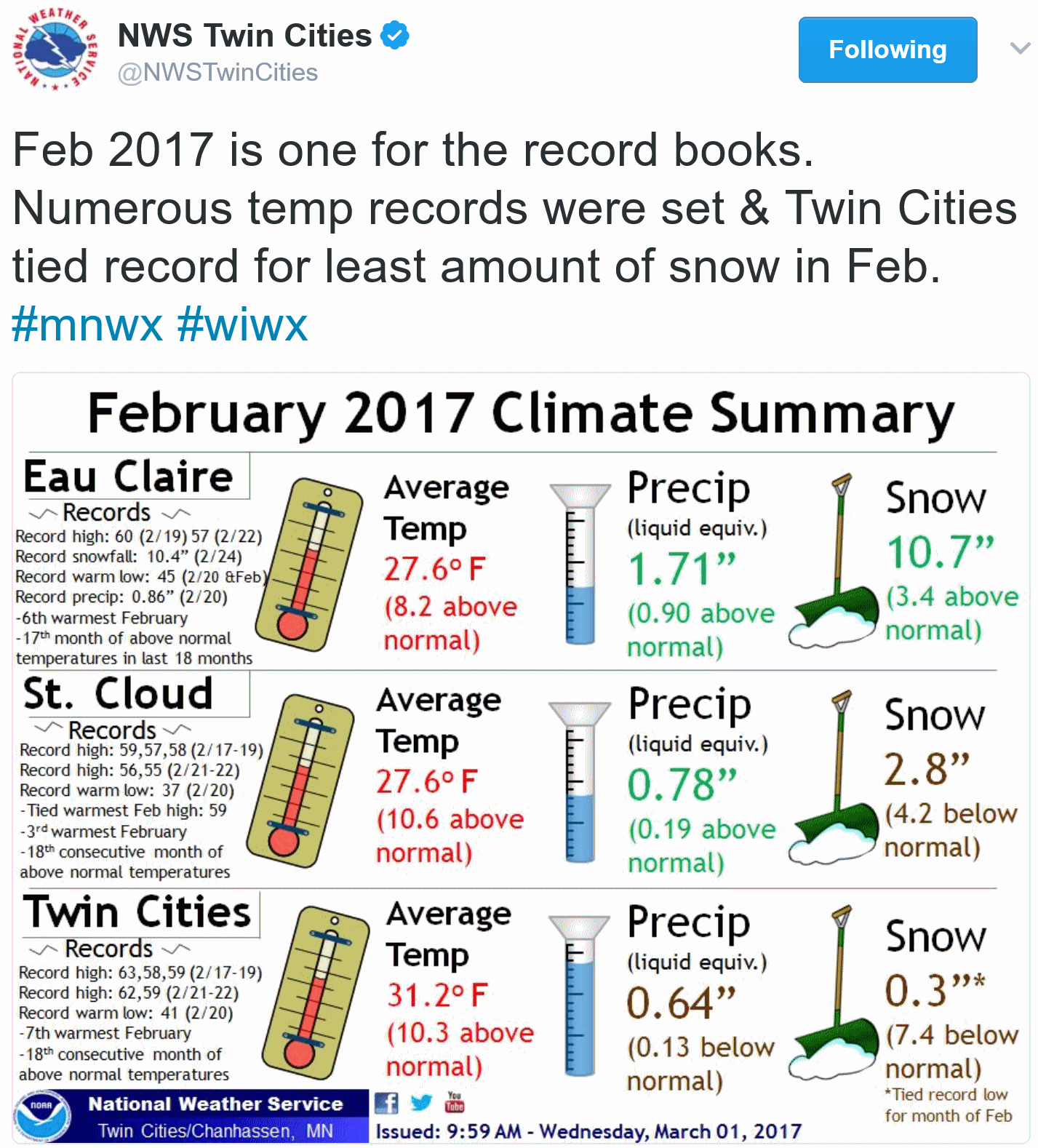
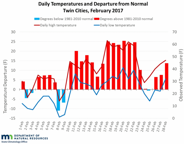
18 Straight Warm Months.
The Minnesota DNR puts our warm streak into perspective: "
Minnesota
is in the grips of a historic warm streak, now standing at 18 months in
many locations, including the Twin Cities. February 2017 started off
relatively tame, with the usual flip-flopping between warm and cold
conditions for the first nine days. The 10th, however, kicked off a
2-week spell of significantly warm weather, including a six-day run
between the 17th and 22nd that broke numerous records.
In the Twin Cities, daily temperatures were above averages on 23 of 28
days, and the average monthly temperature has now been above the 1981-2010 normal for
18 months in a row. As a month, February 2017 was among the warmest on
record across the state. It ranked in the top-10 at Duluth, the Twin
Cities, Rochester, and St. Cloud--where it was 3rd warmest since 1895.
The Twin Cities have not recorded average monthly temperatures that were
below 1981-2010 normals since August 2015. This is the longest
above-average monthly temperature streak of any kind on record in the
Twin Cities, though it is worth noting that the "normals" refresh every
10 years, and procedures for calculating them have changed over time. As
of this writing, only five months out of the last 33 (back to June
2014) have been below normal in the Twin Cities. The second longest
streak on record was 16 months, from June 2011 through September 12..."
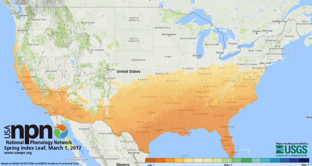
 Early Bird Special: Spring Pops Up Super-Early in Much of U.S.
 Here's an update from
AP: "
Spring
has sprung early — potentially record early — in much of the United
States, bringing celebrations of shorts weather mixed with unease about a
climate gone askew. Crocuses, tulips and other plants are popping up
earlier than usual from Arizona to New Jersey and down to Florida.
Washington is dotted with premature pink blossoming trees. Grackles,
red-winged blackbirds and woodpeckers are just plain early birds this
year. The unseasonably warm weather has the natural world getting ahead
of — even defying — the calendar, scientists said Tuesday. In cities
like Indianapolis, Pittsburgh and Columbus, Ohio, spring has arrived
about a month earlier than the 30-year average and about 20 days earlier
than in 2012, which was the earliest spring on record..."
Spring Has Sprung for Much of America. Here's the latest update from
The USA National Phenology Network: "
How
do you know when spring has begun? Is it the appearance of the first
tiny leaves on the trees, or the first crocus plants peeping through the
snow? The Spring Leaf Index is a synthetic measure of these early
season events in plants, based on recent temperature conditions. This
model allows us to track the progression of spring onset across the
country. The map at right shows locations that have reached the
requirements for the Spring Leaf Index model (based on NOAA National
Centers for Environmental Prediction Real-Time Mesoscale Analysis temperature products). Learn more about the Extended Spring Indices and the data products available. USA-NPN also produces a suite of Accumulated Growing Degree Day map products..."
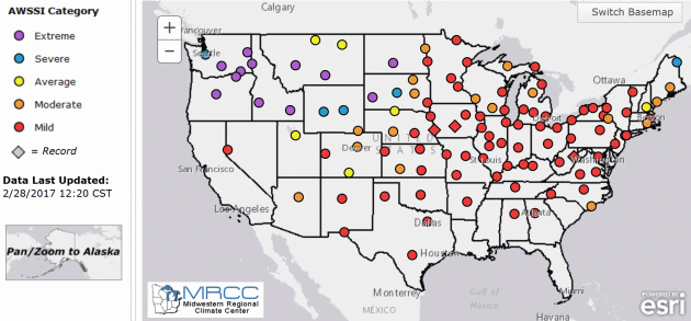
Midwestern Regional Climate Center: "Mild Winter" for Much of the USA. The
MRCC
has an "Accumulated Winter Season Severity Index", which agrees with
the Minnesota DNR's "Winter Misery Index". It wasn't much of a winter.
Details: "
Winter seasons have significant societal impacts across
all sectors ranging from direct human health and mortality to commerce,
transportation, and education. The question “How severe was this
winter?” does not have a simple answer. At the very least, the severity
of a winter is related to the intensity and persistence of cold weather,
the frequency and amount of snow, and the amount and persistence of
snow on the ground. The Accumulated Winter Season Severity Index (AWSSI)
was developed to objectively quantify and describe the relative
severity of the winter season."
Warm Days in February Might Be Here to Stay. Not every February, but most Februarys. Here's a snippet from a
Boston Globe article: "...
All
this unusual weather begs the question: Is this climate change? The
answer is: Sort of. No one single event is climate change, but the odds
of these occurrences can increase as a result of it. It’s like loading
the dice. As the climate continues to change, our weather will throw us
more surprises. No one can say if another February warmth outbreak is
going to occur in 2018 or 2019, but we do know the odds of such winter
warm spells are going to continue to grow. The climate models forecast
more extreme swings in our weather within the general warming pattern.
It’s really no surprise that we are seeing all-time monthly records for
February or severe weather. Since February temperatures are on the rise
and have been for over a hundred years, it stands to reason that
recordbreaking warm days are in our future..."
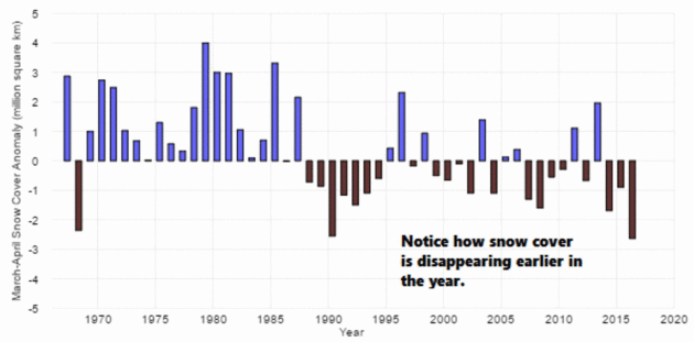
Graphic credit: NOAA. "
Snow cover across North America has been diminishing during March and April for the past 30 years."
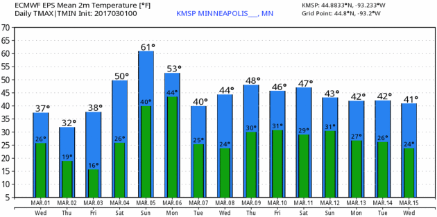
As Chilly As It's Going to Get Next 2 Weeks.
A higher sun angle melted yesterday's inch of slush fairly quickly;
just a few piles of white remaining in the metro. Snow will be a distant
memory by Sunday, when temperatures may surge above 60 F. in the Twin
Cities metro, cooling off into the 40s next week. 15-day MSP Meteogram:
WeatherBell.
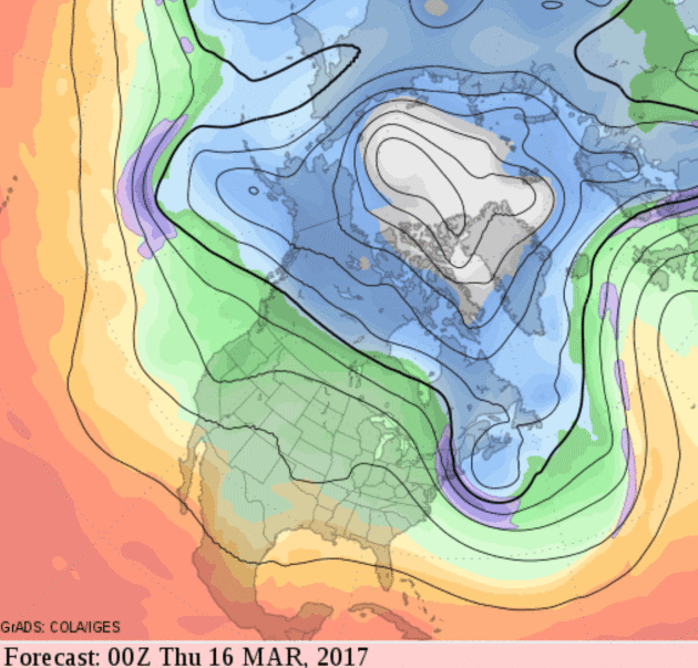
A Dominant Pacific Influence.
A few sneezes of Canadian air will brush the northern USA in coming
weeks, but the models still keep a predominately zonal, west-to-east
wind flow aloft, pumping a steady supply of relatively mild Pacific air
across the USA. 2 weeks out I could see more 50s in Minnesota, if the
GFS forecast of 500 mb (18,000 foot) winds above verifies.
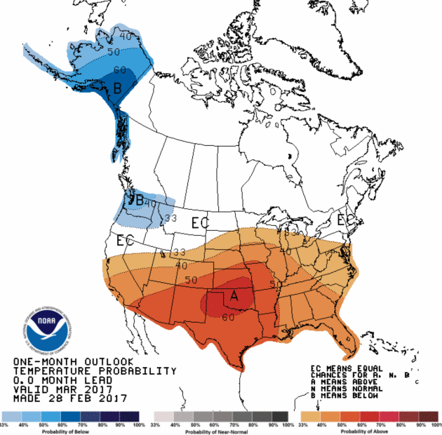
More of the Same For Most of USA.
NOAA CPC
is out with a revised outlook for March temperatures, and much of the
nation is expected to trend warmer than average, with the greatest
potential for warm anomalies over the southern Plains. Only the Pacific
Northwest is forecast to be colder than average.
Life-Saving Tornado Technology Getting Stuck in Congress.
Today's Doppler radars take several minutes at multiple scan levels to
stitch together a 3-D composite of the atmosphere, allowing
meteorologists to see areas of violent rotation. "Phased-array" radars
create an instantaneous, 3-D snapshot of what's happening.
KTUL.com in Tulsa, Oklahoma has a timely story; here's an excerpt: "...
There’s
new technology at the National Severe Storms Lab in Norman that has
shown the ability to allow extra minutes of lead time. Precious minutes
that could be part of the solution. It’s something we’ve never seen
before. Tornadoes on radar in their earliest stages of formation.
“Phased array radars have been around for a long time,” says Kurt Hondl,
a researcher at N.O.A.A. “Primarily for use by the military, the
simplest way to think about it are your ears as a phased array system.
If you close your eyes and somebody walks around the room, you can still
tell where the voice is coming from.” “It would be lifesaving,” Weir
says. “It would be immensely valuable, especially with the schools that
lost so many children here...”
 Phased-Array Radar Could Improve Tornado Prediction Times
.
IEEE Spectrum
has a good backgrounder piece on the benefits of phased-array; the U.S.
Navy has been using it to track missiles - it only makes sense to see a
trickle-down from military to the consumer sector: "...
A
phased-array radar can capture the scene much more quickly. This type of
radar system features a fixed, flat antenna composed of thousands of
transceiver elements sending and receiving pulses at the same time. The
relative delays between the pulses shape the direction of the beam
radiating from the array. This electronically steered beam can scan the
whole sky in less than a minute. Forecasters would also be able to
instantly redirect it to focus on specific areas. "It gives forecasters
information almost like a movie, as opposed to taking snapshots of the
atmosphere," says Doug Forsyth, who leads radar research at the NSSL.
U.S. Navy ships have used phased-array radars for decades to detect
missile threats. In fact, since 2003, the NSSL has been testing an
antenna donated by the Navy. A group of National Weather Service
forecasters are invited to participate in the trials, which include
yearly mock tests on real tornado data..."
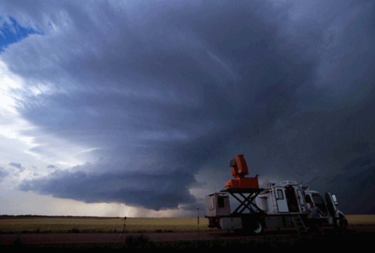
Photo credit: Mobile, phased-array Doppler radar scanning a supercell in Kansas during VORTEX-2 on June 9, 2009. Coutesy:
University of Oklahoma, Norman.
Don Paul: "Twister" and the State of Tornado Chasing. A friend in Buffalo, meteorologist Don Paul, wrote a good article for The Buffalo News; here's an excerpt: "...In this next year, it’s remote data from space which may well be the most important new tool for researchers. The GOES-R satellite, still in test mode,
has the ability to do rapid scan extremely high resolution images of a
focused small area every 30 seconds. Such imagery can’t see everything
inside storm cells and supercells, but the change in cloud top
configuration, cloud top temperature, visible gust fronts out ahead of
the storm, and the satellite’s superior lightning detection will provide
far more rapid data on changes in storm development than can be
supplied by the network of NWS Dopplers, which take about six minutes to
complete a complete set of scans of many different altitudes within a
storm to determine a more complete picture of its structure. As I’ve
written, the U.S. still lags in our global weather models in many
respects compared to the European Center and the British Met Office.
When it comes to the study of severe local convection, though, we are
unquestionably the world leader. We have to be. Our tornado frequency,
due to our geography, is incomparably higher than that of any other
continent..."
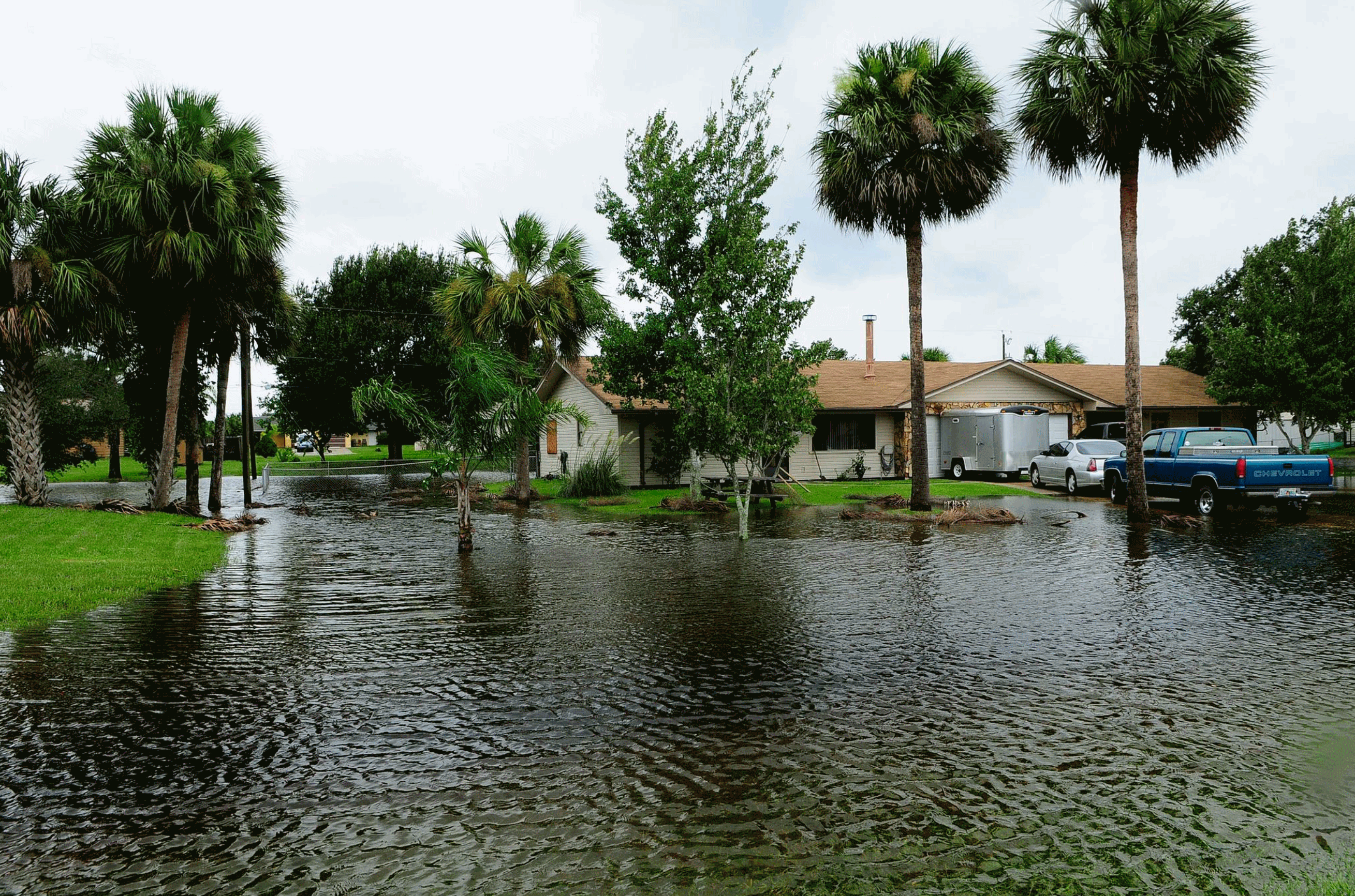
 Have We Underestimated the West's Super-Floods?
This winter is redefining wet for California and the entire west coast
of the USA, but it pales in comparison to previous deluges. Here's an
excerpt from
High Country News: "...
In
California, too, super-floods may be more common than previously
thought. United States Geological Survey hydrologist Michael Dettinger
and UC Berkeley paleoclimatologist B. Lynn Ingram have studied the
paleo-flood record across a broad swath of California and discovered
that such floods happen at least every 200 years, and maybe more
frequently. The last one was in 1862.
Thousands of people died, towns were submerged and the state’s economy
was devastated, yet it was nowhere near the worst: One flood in the
1600s was at least twice as big..."
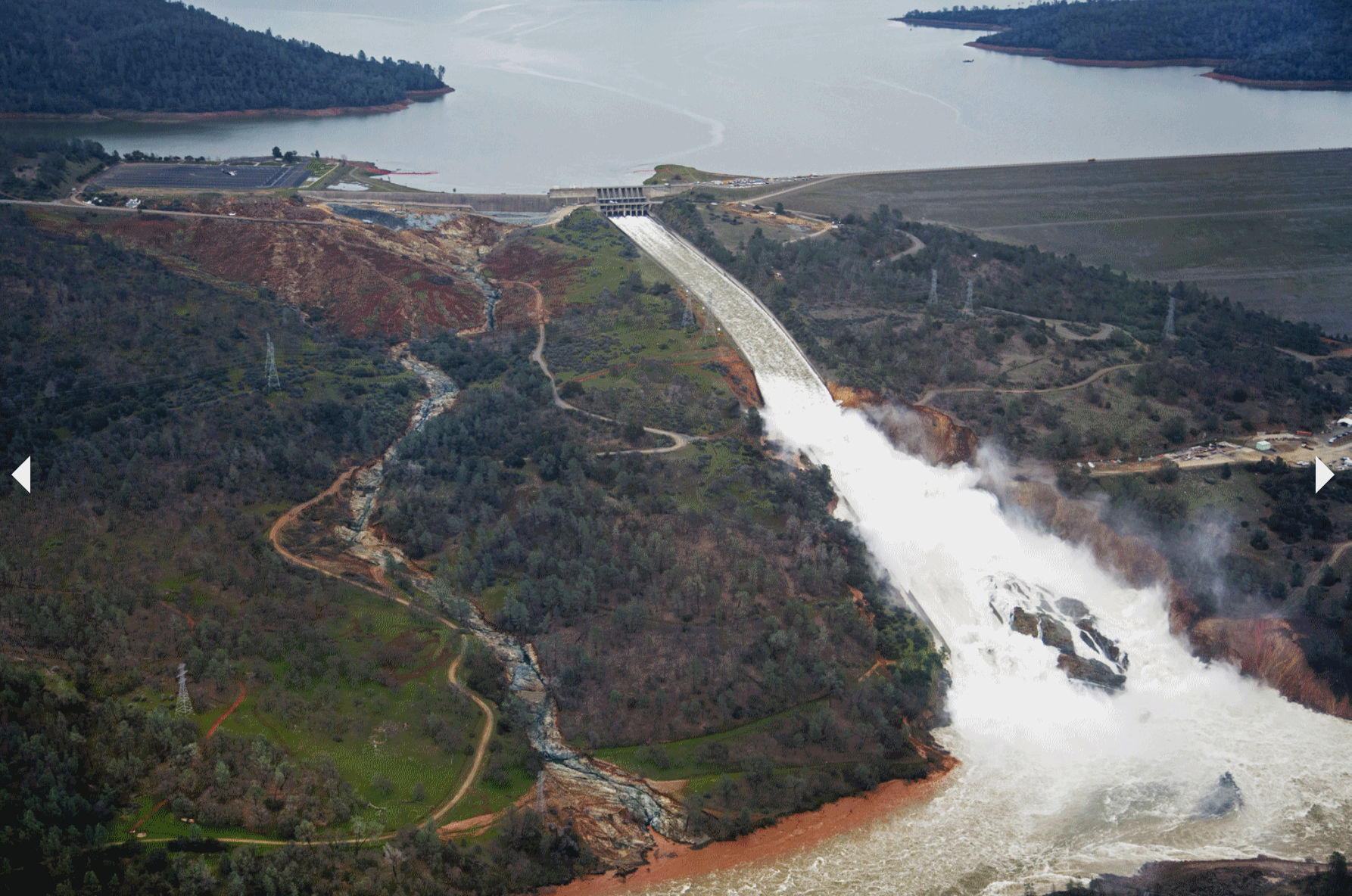
Photo credit: "The damaged Oroville Dam spillway flows out of Lake Oroville at 100,000 cubic feet per second (cfs)." Dale Kolke / California Department of Water Resources.
Dale Kolke / California Department of Water Resources
 Smaller Storms, Over Time Can Cost More Than Extreme Infrequent Events. Details via AGU, American Geophysical Union: "Global
climate change is being felt in many coastal communities of the United
States, not always in the form of big weather disasters but as a drip,
drip, drip of nuisance flooding. According to researchers at the
University of California, Irvine, rising sea levels will cause these
smaller events to become increasingly frequent in the future, and the
cumulative effect will become comparable to extreme events such
as Hurricane Katrina or Superstorm Sandy. “Catastrophic storms get a lot
of media attention and are studied, but we wanted to know more about
the non-extreme events,” said Amir AghaKouchak, associate professor of
civil and environmental engineering at the University of California
Irvine (UCI) and co-author of a new study on cumulative hazards in Earth’s Future, a journal of the American Geophysical Union.
Smaller Storms, Over Time Can Cost More Than Extreme Infrequent Events. Details via AGU, American Geophysical Union: "Global
climate change is being felt in many coastal communities of the United
States, not always in the form of big weather disasters but as a drip,
drip, drip of nuisance flooding. According to researchers at the
University of California, Irvine, rising sea levels will cause these
smaller events to become increasingly frequent in the future, and the
cumulative effect will become comparable to extreme events such
as Hurricane Katrina or Superstorm Sandy. “Catastrophic storms get a lot
of media attention and are studied, but we wanted to know more about
the non-extreme events,” said Amir AghaKouchak, associate professor of
civil and environmental engineering at the University of California
Irvine (UCI) and co-author of a new study on cumulative hazards in Earth’s Future, a journal of the American Geophysical Union..."
Photo credit: FEMA. "
The
effects of climate change are being felt now in American cities. With
the steady rise in sea level over the past few decades, events such as
an especially strong tide can result in flooding in coastal regions, a
new study finds."
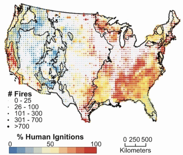
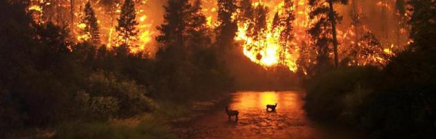
Humans Are Responsible for 84 Percent of Wildfires in the U.S. Atlas Obscura has details: "
In
the past decades, the number of wildfires in the U.S. has spiraled
upwards, as has the cost of fighting them: In recent years, by the end
of the fire season, the Forest Service has usually exhausted its budget. According to a new paper, published in the Proceedings of the National Academy of Sciences,
one factor contributing to the increasing impact of wildfire is how
often humans ignite them. The team of researchers found that, from 1992
to 2012, people were responsible for starting 84 percent of wildfires
and that, in most of the U.S., it’s more common from humans to start
wildfires than for lightning to ignite them, as they report in the new paper..."
Humans Are Igniting the Vast Majority of Wildfires in the U.S. Pacific Standard has the results of new research: "...
Looking
at 1.5 million records of wildfires with a known cause that took place
between 1992 and 2012, the researchers found that humans started 84
percent of the fires over the 20-year period and tripled the length of
the fire season. Lightning-ignited fires were most likely during the
summer months, and during the spring, winter, and fall, human-induced
blazes were 35 times more likely than lightning-started ones. People
started plenty of summertime blazes as well; in fact, more human-ignited
fires were started on July 4th than any other day of the year. But the
outsize role people play in sparking wildfires doesn’t preclude climate
change from blame..."
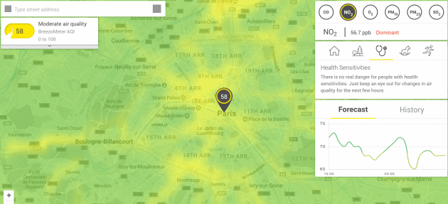
This Real-Time Pollution Map Will Enlighten You On Your City's Air Quality.
Yahoo News has the story: "...
The map
delivers real-time information on air pollution along with hourly
forecasts and helpful weather-related health and fitness
recommendations. Its data is drawn from "official air quality sensors"
placed across cities that monitor airborne particles and combined with
information on wind, weather and traffic conditions. By simply searching
a location, users will be shown a color-coded map of the pollution
level in the surrounding area. They'll also receive useful information
such as carbon monoxide and ozone levels, weather forecast updates, and
heath, sports and child care-related suggestions..."
Trump Order Will Aim To Roll Back a Clean Water Rule.
Is this to protect farmers and fossil fuel interests at the expense of
consumers, or does agriculture and industry have a legitimate gripe?
The New York Times reports: "
President
Trump is expected to sign an executive order on Tuesday aimed at
rolling back one of former President Barack Obama’s major environmental
regulations, a clean water rule known as Waters of the United States.
But on its own, Mr. Trump’s order will have almost no legal effect on
the sweeping rule, which was imposed in 2015, according to two people
familiar with the White House plans. An advance copy of the order was
viewed by The New York Times on Monday. The order will essentially give
Mr. Trump a megaphone to direct his new Environmental Protection Agency
administrator, Scott Pruitt, to begin the lengthy and complicated legal
process required to rewrite the rule — a process that could take longer
than Mr. Trump’s first term, legal experts said..."
Photo credit: "A
commercial fisherman crosses the Chesapeake Bay in Maryland. The clean
water rule, called Waters of the United States, authorizes the federal
government to limit pollution." Credit Jonathan Ernst/Reuters.
 Trump to Put Obama Water Pollution Rule on Chopping Block. A case of over-regulation; federal over-reach? Here's more perspective from Bloomberg: "...In
imposing the Waters of the U.S. rule, the Obama administration’s EPA
aimed to resolve decades of uncertainty over what waterways were subject
to federal regulation and oversight. In 2006, the U.S. Supreme Court
fractured over the question of whether strictly navigable waters are
subject to the Clean Water Act, or if the jurisdiction goes further.
Developers said later guidance from the EPA only injected more confusion
into permitting processes. Obama’s Waters of the U.S. rule was opposed
by dozens of states and an assortment of business and agriculture
groups, which complained it did nothing to clear up the murkiness and
took an overly expansive view of the law.
Trump to Put Obama Water Pollution Rule on Chopping Block. A case of over-regulation; federal over-reach? Here's more perspective from Bloomberg: "...In
imposing the Waters of the U.S. rule, the Obama administration’s EPA
aimed to resolve decades of uncertainty over what waterways were subject
to federal regulation and oversight. In 2006, the U.S. Supreme Court
fractured over the question of whether strictly navigable waters are
subject to the Clean Water Act, or if the jurisdiction goes further.
Developers said later guidance from the EPA only injected more confusion
into permitting processes. Obama’s Waters of the U.S. rule was opposed
by dozens of states and an assortment of business and agriculture
groups, which complained it did nothing to clear up the murkiness and
took an overly expansive view of the law..."
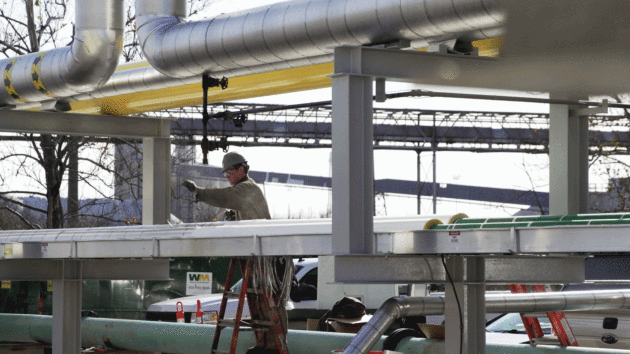
Minnesota To See First Hybrid Wind-Solar Project.
North American Windpower has the story: "
GE Renewable Energy has been selected
to supply equipment for what it says will be the first commercial
integrated solar-wind hybrid power generation project in the U.S. The
4.6 MW, community-based project will be situated in Red Lake Falls,
Minn. Developed by Juhl Energy, the project will use two 2.3-116 wind
turbines from GE’s onshore wind business and 1 MW of solar conversion
equipment from GE’s current business. GE expects the project to enter
commercial operations in August. GE will also provide its Wind
Integrated Solar Energy technology platform, developed through the
company’s global research center. The platform will integrate the solar
panels through the wind turbine’s converter directly. According to GE,
the hybrid design will enable the project to produce power when it is
most needed: Basically, the solar provides summer peak energy, and the
wind provides winter peak energy..."
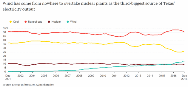
A Texas Tornado for America's Power Players. Cleaner, cheaper renewable power is disrupting America's energy business - here's an excerpt from
Bloomberg Gadfly: "...
Renewable
energy has a particularly pernicious effect on wholesale power prices
because of the way they are set. As you might expect, the last source of
generation to be switched on in order to meet demand is the most
expensive one. Back in the day, this so-called "merit order" generally
ran like this: nuclear first, then coal, then maybe some natural gas,
and finally, if there was a sudden surge of demand, a "peaker-plant"
burning gas or even oil. Renewables mess with this because, once built,
their fuel is generally free. So, as long as the wind is blowing or the
sun is shining, they will run first, displacing higher-cost sources of
power. This tends to depress the whole market, as that last
kilowatt-hour of supply needed to meet demand comes from a lower-cost
source (this is also why cheap natural gas has savaged demand for coal)..."
Graphic credit: "
Note: Share of electricity output by major energy source, trailing 12-month averages."
Conversion to Natural Gas Brings New Life to Aging Coal Plants.
Midwest Energy News reports: "
It
used to be that a train of coal arrived every day at the Joliet coal
plant 40 miles southwest of Chicago. Forty-seven conveyor belts fed the
coal into units on either side of the Des Plaines River. And workers
busily transferred the coal from the train and maintained the system. Today
there are no more coal trains. But Joliet is not among the scores of
coal plants that have closed in recent years. Instead, it burns natural gas.
A number of coal plants nationwide have converted to natural gas, a
move that uses much of the same infrastructure but involves different
economics, less pollution and fewer workers. Unlike
the coal plant which ran nearly around the clock, the Joliet plant,
owned by NRG, now fires up and down more frequently depending on demand
and profitability..."

The Mobile Solar Boom is Just Beginning. Solar can pull people out of energy poverty faster/cheaper/cleaner. A principal in the company
Lumos explains at
TheHill: "...
Lumos
brings affordable, accessible, and reliable solar energy to off-grid
homes. By partnering with mobile operators, Lumos allows customers to
pay for their electricity with existing mobile phone accounts. I believe
that this is the solution for the billion people who are living with a
mobile phone and without reliable electricity. For only 50 US cents a
day, customers can power lights, a fan, a tv, mobile chargers, and small
appliances all at the same time. For decades, these off-grid
communities have been underserved. With Lumos and mobile operators
working together, students are able to do homework at night,
entrepreneurs can keep stores open after dark, health clinics and
religious centers can further their mission, and billions of people are
able to connect to one another with cellphones they previously couldn’t
reliably charge..."
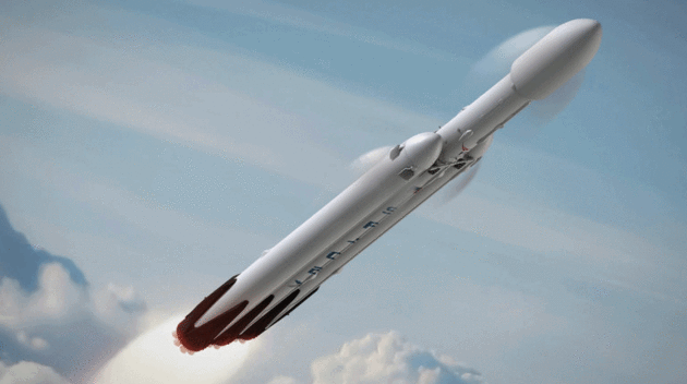
SpaceX Plans to Send 2 Tourists Around Moon in 2018. Serenaded by Pink Floyd as they travel around the dark side of the moon? Sign me up (and have someone else pay for it).
The New York Times reports: "
SpaceX, the ambitious rocket company headed by Elon Musk, wants to send a couple of tourists around the moon and back to Earth
before the end of next year. If they manage that feat, the passengers
would be the first humans to venture that far into space in more than 40
years. Mr. Musk made the announcement on Monday in a telephone news
conference. He said two private individuals approached the company to
see if SpaceX would be willing to send them on a weeklong cruise, which
would fly past the surface of the moon — but not land — and continue outward before gravity turned the spacecraft around and brought it back to Earth for a landing..."
Image credit: "A rendering of the SpaceX Falcon Heavy rocket that may be used to launch two people on a journey around the moon." Credit SpaceX.
Minnesota: 3rd Best State in the USA? I beg to differ, but
U.S. News has Massachusetts and New Hampshire ahead of the Land of 10,000 Lakes: "...
In addition to its harsh winters, the state is known for its many bodies of water,
which eventually flow into the Hudson Bay, the Atlantic Ocean and the
Gulf of Mexico. The headwaters of the Mississippi River start in
northern Lake Itasca, where loons serenade at sunset. The Dakota fittingly named the land “Minisota,” meaning sky-tinted water. The state’s nickname as the Land of 10,000 Lakes is an understatement – the state actually boasts 11,842. Minnesota’s population is expected to reach 6 million by 2032. The state’s demographics will likely shift over the next couple of decades, moving toward an older and more diverse
population. Minnesota’s 65 and older population, demographers say, will
outnumber people 17 and younger for the first time in 2035.
Additionally, Minnesota’s nonwhite and/or Latino population is expected
to rise to 25 percent, up 11 percent from 2005..."
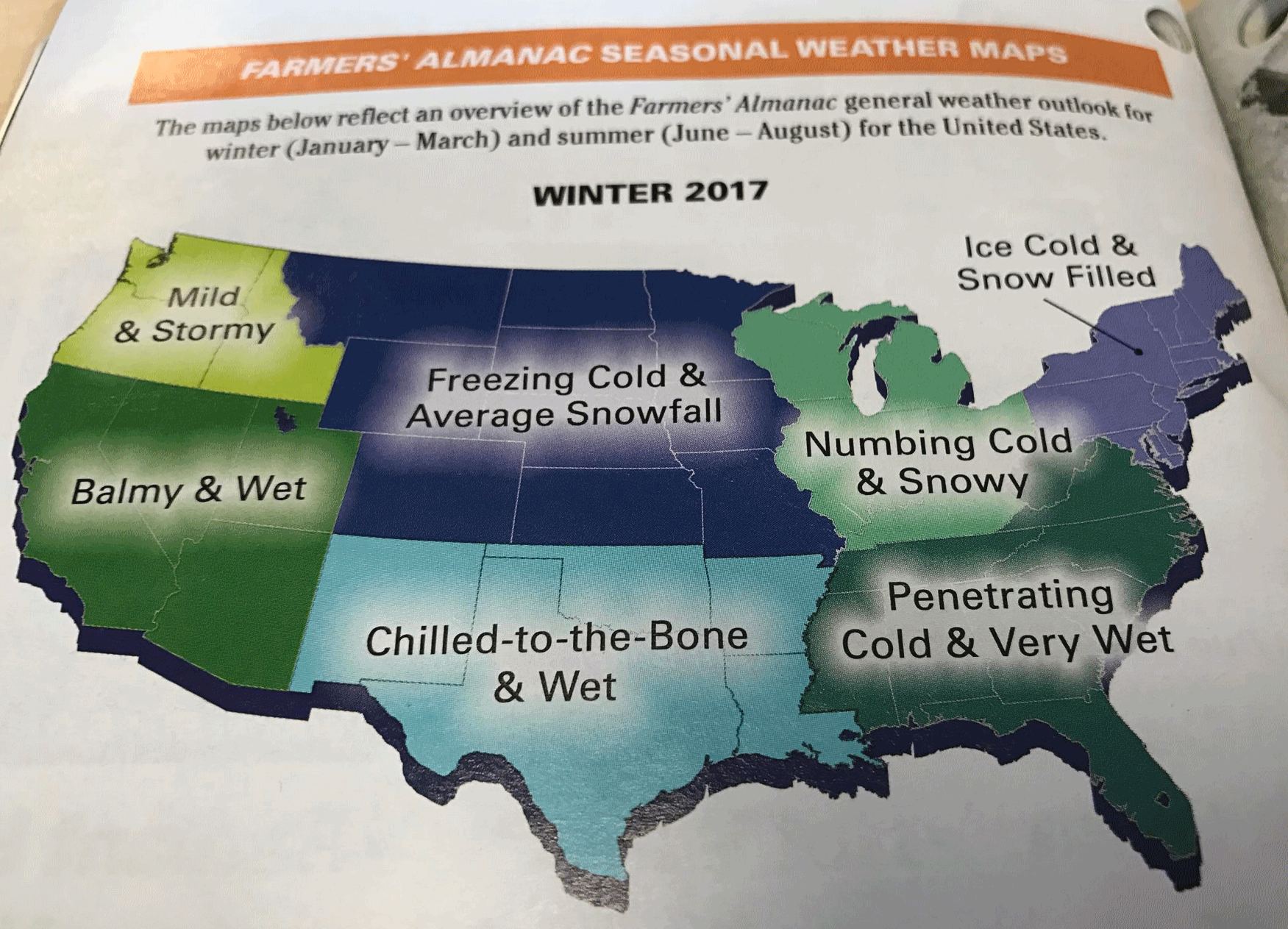 Didn't Quite Work Out That Way
. Here is what the Farmer's Almanac was predicting for January through March of 2017.
TODAY: Clouds, few flurries, cooler than average. Winds: NW 8-13. High: 32
THURSDAY NIGHT: Partly cloudy, feels like winter. Low: 14
FRIDAY: More sun, less wind. Still chilly. Winds: S 8-13. High: 34
SATURDAY: Patchy clouds, milder breeze. Winds: SE 10-20. Wake-up: 25. High: 48
SUNDAY: Welcome to April. Partly sunny. Winds: SW 8-13. Wake-up: 38. High: near 60
MONDAY: Still balmy, passing T-shower? Winds: S 15-25. Wake-up: 49. High: 62
TUESDAY: Gusty and cooler. Sprinkles/flurries. Winds: NW 10-20. Wake-up: 36. High: 42
WEDNESDAY: Plenty of sun, winds ease up. Winds: E 5-10. Wake-up: 26. High: 44
Climate Stories....
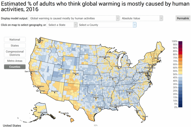
Yale Climate Opinion Maps. A
majority of Americans acknowledge the climate is changing; a smaller
percentage link warming to human activities, as reported by the
Yale Program on Climate Change Communication: "
This
version of the Yale Climate Opinion Maps is based on data through the
year 2016. Public opinion about global warming is an important influence
on decision making about policies to reduce global warming or prepare
for the impacts, but American opinions vary widely depending on where
people live. So why would we rely on just one national number to
understand public responses to climate change at the state and local
levels? Public opinion polling is generally done at the national level,
because local level polling is very costly and time intensive. Our team
of scientists, however, has developed a geographic and statistical model
to downscale national public opinion results to the state,
congressional district, and county levels. We can now estimate public
opinion across the country and a rich picture of the diversity of
Americans’ beliefs, attitudes, and policy support is revealed. For
instance, nationally, 70% of Americans think global warming is happening..."
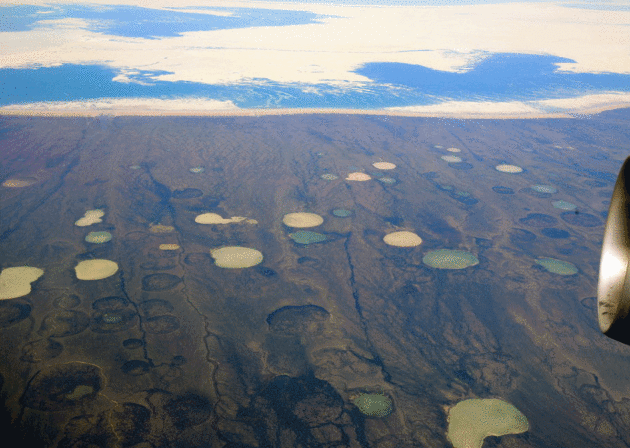
Massive Permafrost Thaw Documented in Canada, Portends Huge Carbon Release. Details via
InsideClimate News: "
Huge
slabs of Arctic permafrost in northwest Canada are slumping and
disintegrating, sending large amounts of carbon-rich mud and silt into
streams and rivers. A new study that analyzed nearly a half-million
square miles in northwest Canada found that this permafrost decay is
affecting 52,000 square miles of that vast stretch of earth—an expanse
the size of Alabama. According to researchers with the Northwest Territories Geological Survey,
the permafrost collapse is intensifying and causing landslides into
rivers and lakes that can choke off life downstream, all the way to
where the rivers discharge into the Pacific Ocean..."
File photo credit: "Melting permafrost is altering the landscape in northern Canada on a grand scale." Credit: Wikimedia.
The Scientific Community is Facing an Existential Crisis.
New Republic explains why: "...
Most
scientists are uncomfortable talking politics because their work needs
to be perceived as objective rather than partisan. But ever since
America elected a president who’s made scientifically inaccurate
statements on everything from vaccines to climate change,
more and more scientists are stepping into the spotlight to stand up
for their profession. That includes Holt, who announced Wednesday that
AAAS would partner with the March for Science,
an Earth Day rally with the primary goal of preserving and promoting
evidence-based policymaking. In a conversation with the New Republic,
Holt—who is also a former U.S. Congressman—talked about the
unprecedented level of political anxiety among American scientists, and
how those scientists should navigate these murky waters..."
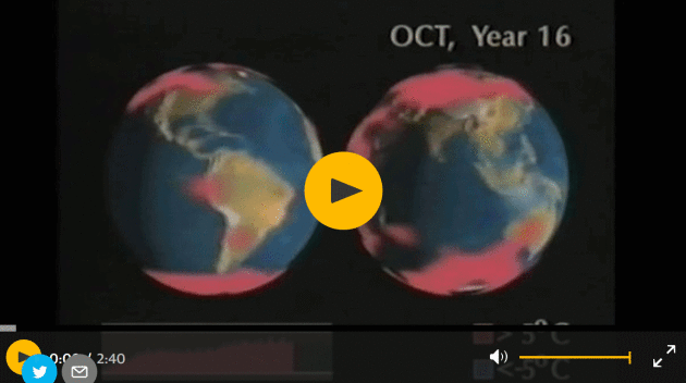
"Shell Knew": Oil Giant's 1991 Film Warned of Climate Change Danger. Details, and a link to a 2:40 video overview, courtesy of
The Guardian: "
The
oil giant Shell issued a stark warning of the catastrophic risks of
climate change more than a quarter of century ago in a prescient 1991
film that has been rediscovered. However, since then the company has
invested heavily in highly polluting oil reserves and helped lobby
against climate action, leading to accusations that Shell knew the grave
risks of global warming but did not act accordingly. Shell’s 28-minute
film, called Climate of Concern, was made for public viewing,
particularly in schools and universities. It warned of extreme weather,
floods, famines and climate refugees as fossil fuel burning warmed the
world. The serious warning was “endorsed by a uniquely broad consensus
of scientists in their report to the United Nations at the end of 1990”,
the film noted..."
Image credit:
What Shell knew about climate change in 1991
"A Sense of Despair" : The Mental Health Cost of Unchecked Climate Change. CBS News reports; here are 2 excerpts from an eye-opening story: "...
Climate
change is taking an obvious physical toll on earth: from depleted
farmland to the rise of toxic pollution to the degradation of
long-stable ecosystems to the disappearance of biodiversity and
endangered species. But looking beyond the physical, experts are also
trying to sound the alarm about the quieter, more insidious effects of climate change: namely, that global warming is threatening the emotional health of humans
worldwide. “We see a sense of despair that sets in as inevitably Mother
Nature, who we think of as our nurturing force, tells us we’re not
going to be able to survive the conditions she’s set for us,” Dr. Lise
Van Susteran, a practicing psychiatrist and expert on the dangers of
climate change on mental health, told CBS News...
The
researchers found that just one standard-deviation shift in heat or
rainfall increases the risk of a riot, civil war or ethnic conflict by
an average of about 14 percent. A similarly sized uptick in heat or rain
triggers a 4 percent increase in person-on-person violence like rape,
murder and assault..."
 6 Words That Could Go Extinct Because of Climate Change
.
Outside Magazine reports:
Lift
Line. Noun: The queue of skiers and snowboarders waiting to board a
chairlift for a ride up the mountain at a winter resort. This winter,
ski resorts have seen record-breaking storms and crowds. So climate
threats must be a Cascadian hoax, right? No. Though colder and warmer
winters are determined mainly by fickle jet streams, global warming has
contributed to an increased number of “End of Days” storms over the past half-century. The average global temperature has risen 1.5 degrees Fahrenheit
since 1880: warmer weather means more moisture in the air, which means
more intense precipitation events. At lower elevations, another
two-degree temperature increase has the potential to turn all that fresh
powder into floods and landslides. And you may have noticed this winter
that the season is getting shorter. While there might be a few epic days in the middle of winter, there’s less time on either end of winter..."
Photo credit:
"Many glacier tips are attached to an unmoving sliver of ice called an "icefoot." Photo: Oskari Porkka/iStock.
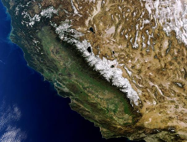
With Climate Change California is Likely to See More Extreme Flooding. NPR has the story; here's a clip that caught my eye: "...
But
this shouldn't be a surprise, says Noah Diffenbaugh, a climate
scientist at Stanford University. "It's actually exactly what has been
predicted by scientists for at least 30 years," he says. He says
California is likely to see more extreme flooding with climate change.
And the reason is pretty simple. If it's warmer, storms produce more
rain instead of snow. But that's not what California's water system was
built to do when it was designed a century ago. It was built, in large
part, around the snowpack in the Sierra Nevada. The state's flood system
can handle that slow melt, but not a huge amount of rain all at once,
Diffenbaugh says..." (File image credit: ESA).
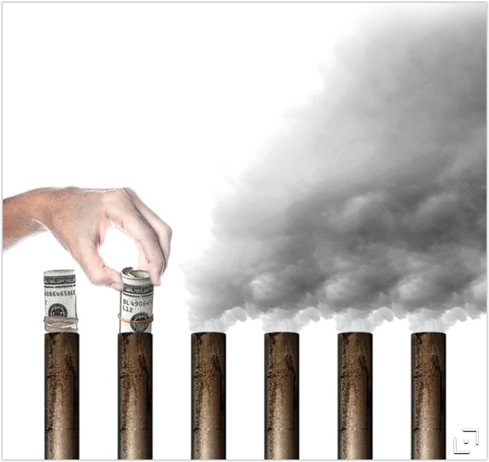 What is Wrong With a Carbon Tax?
 The author of a
Scientific American Op-Ed (who happens to be an economist) argues for a cap and dividend approach, instead of tax and dividend: "...
The
upshot is that a carbon tax is not only a nonstarter in terms of good
political optics, but also in terms of good economics, ethics and
science. That said, while the CLC should ditch the tax, the public
dividend component of their plan is worth keeping. As they convincingly
argue, the dividend is a brilliant way to overcome political resistance
to a carbon fee by giving every American with a social security number
an immediate economic stake in the program. For example, the CLC
estimates that at their suggested $40/ton level, “a family of four would
receive approximately $2000 in carbon dividend payments in their first
year.” As with social security, payouts would go to rich and poor alike,
thus generating sufficient popularity to protect the program against
shifting political winds..." (File image: Star Tribune).


No comments:
Post a Comment