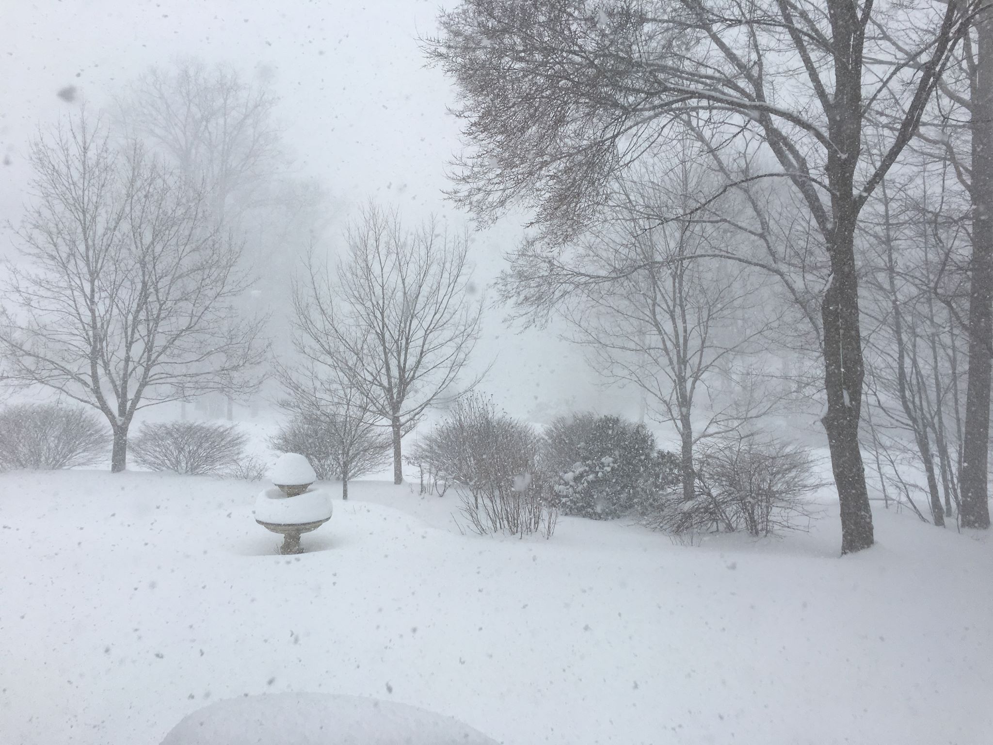
Heavy Snow in the Northeast
Thanks to Noreen Clark from Mountain Top, PA for the picture below who has been busy keeping the snow totals rolling since late Monday night. Noreen measured an additional 5.0" of snow on Wednesday on top to the 20.8" of snow on Tuesday! Incredibly, snowfall rates with this particular storm on Tuesday were on the order of 2" to 4" per hour at times. It came down fast and furious with winds gusting up to 50mph or more made for a very wintry early week time frame across the Northeast. Widespread 1ft to 2ft amounts blanketed much of the region with some 3ft to near 4ft tallies also being reported. Folks will spend much of the rest of the week cleaning up after this particular mid March snow event. WOW!
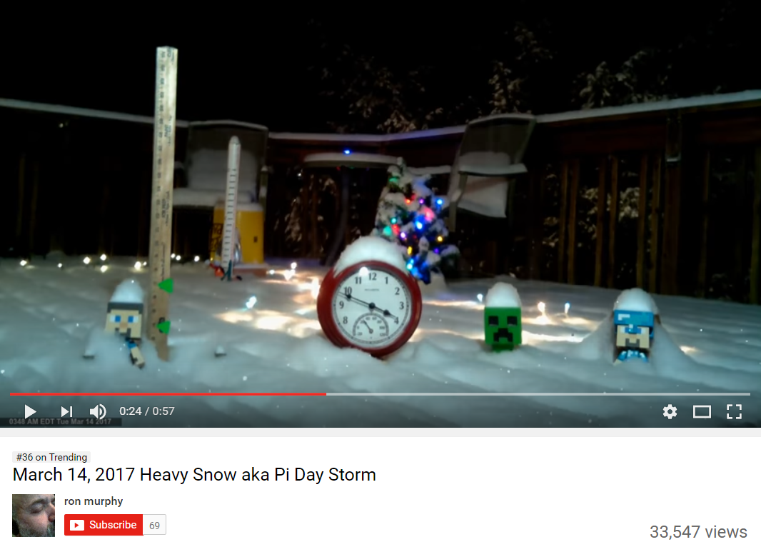
Heavy Snow on Pi Day
How cool is this? This youtube video from Ron Murphy shows a time lapse of the heavy snow event from the Northeast earlier this week. Ron is calling it the Pi Day storm since most of the snow fell on March 14th... for you math lovers, the number Pi is 3.14159.... shortening that number to 3.14, it corresponds with 3/14 or March 14th.
Heavy Snow in the Northeast
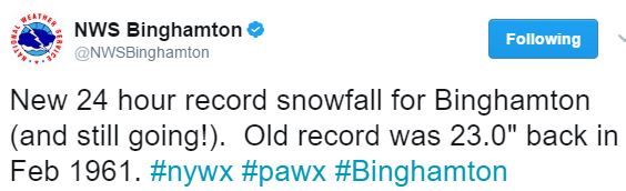
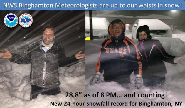
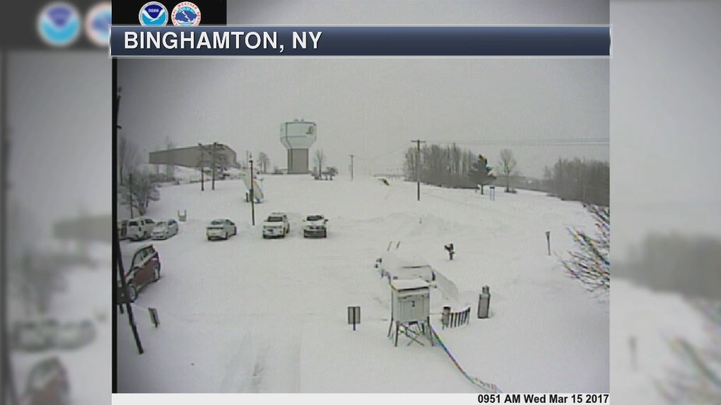
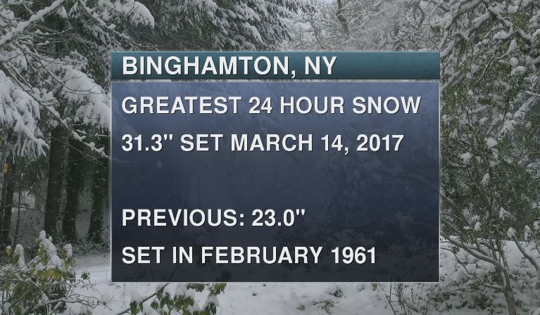
Here's a classic picture of meteorologists geeking out over snow! Take a look at this Twitter post from the National Weather Service out of Binghamton, NY at 8pm Tuesday night! At that point, they were up to their waists in snow. The 24 hour snowfall tally in Binghamton was 31.3" smashing the old 24 hour snowfall record set in February 1961! WOW!
Greatest 24 Hour Snowfall in Binghamton, NY
Binghamton, NY has an impressive 24 hour span on Tuesday, March 14th. In fact, they set a new 24 hour snowfall record of 31.3"!! That's incredible! Interestingly, 11.6" of that snow came down in a 4 hour time frame on Tuesday morning... good grief! Note that the previous 24 hour snowfall record was 23.0" set in February 1961. The picture below is from the National Weather Service in Binghamton, NY early Wednesday morning... They've certainly had a busy week so far out there.
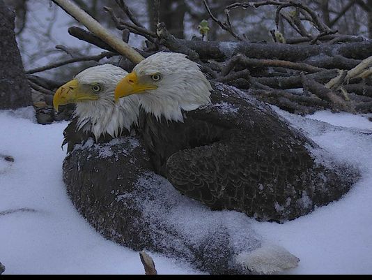
"World watches nesting eagles fight storm to save eggs"
This is a neat story... a pair of eagles try to save their eggs from the major winter storm that battered the Northeast earlier this week. Here's an excerpt from USAToday.com: Winter storm Stella brutalized parts of the Northeast on Tuesday, but one undaunted couple fought the forces of nature to protect their offspring. Mr. President and The First Lady, a bald eagle pair nesting at the U.S. National Arboretum in Washington, D.C., hunkered down in the snow and cold to save their two eggs, which are expected to hatch later this month. The determined duo’s battle was watched live from around the world thanks to the DC Eagle Cam Project, a cooperative public education project between the American Eagle Foundation based in Pigeon Forge, Tenn., and the U.S. Department of Agriculture. The First Lady covered the eggs with her body as she allowed herself to be covered by snow and ice. Mr. President joined her, partially covering her body with his wings as snow and ice accumulated on him. They continued to keep their bodies close, exchanging warmth and attempting to protect their future eaglets.
See more from USAToday.com HERE:
(Photo: American Eagle Foundation)
See more from USAToday.com HERE:
(Photo: American Eagle Foundation)
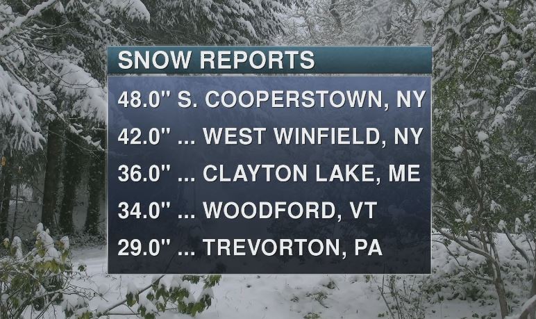
How Much Snow Actually Fell?
Here are some the heaviest snowfall reports that I could find from around the area. Note that there were widespread 1ft to 2ft amount, but some locations saw nearly 3ft to 4ft! I couldn't imagine having that much snow fall in such a short amount of time... unreal.
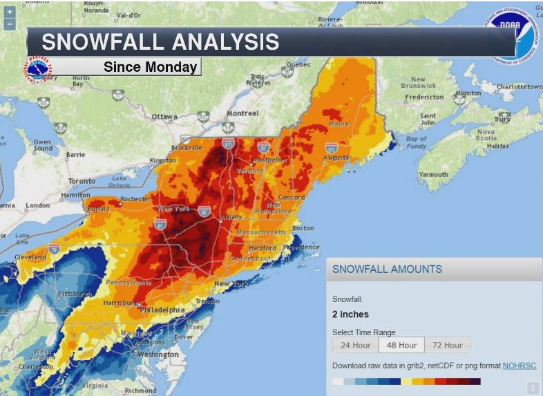
Snowfall Analysis
The map below shows the snowfall analysis from AM Monday to AM Wednesday. Note how widespread the heavy snow was across much of the area. Again, widespread 1ft to 2ft amounts can be seen here with embedded 3ft to near 4ft amounts as well!
Satellite Loop of Storm System on Tuesday
This is what the storm looked like on visible satellite as the sun was going down on Tuesday. The storm was massive that had major impacts on many locations from the Northeast to parts of southeastern Canada.
.gif)
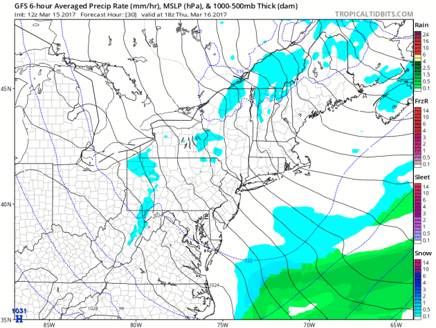
Quieter End of Week - More Snow This Weekend?
Here's the simulated radar from Thursday to Sunday, which shows a fairly quiet conditions through the end of the week, but another storm system looks to quickly move in this weekend with additional snowfall potential. While this storm doesn't look as potent as the last storm, additional snowfall accumulations will be possible.
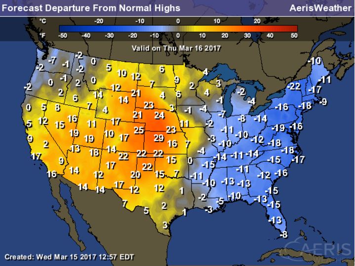
Cold Temps in the Wake of the Storm...
Temperatures in the wake of the storm system will be quite chilly across the eastern US on Thursday, here's a look at the high temperatures from average on Thursday. Note that some spots may be as much as 10F to 20F below average for March 16th!
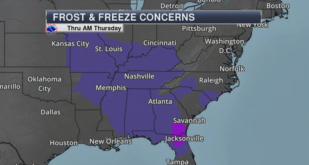
Frost & Freeze Concerns
According to the National Phenology Network, the spring leaf index suggests that the first spring leaves have popped up as far north as the Ohio River Valley and across parts of the Central US. With that said, temperatures at or well below the freezing will likely freeze any newly budded plants across the region. Note that frost/freeze concerns will be as far south as Florida through AM Thursday!
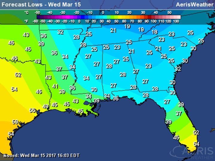
Low Temps AM Thursday...
Here's a look at low temperatures by Thursday morning. Note that temperatures could dip into the upper 20s as far south as northern Florida, while temps across parts of the Ohio Valley could dip into the 10s. Widespread frost and freeze conditions will be likely and for several hours through AM Thursday.
______________________________________________________
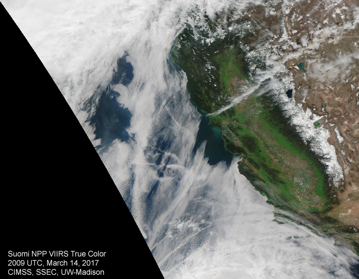
California Ready for St. Patty's Day
WOW! Look at how green California is right now... This visible satellite image from March 14th showed a brilliant green hue across much of the state thanks to significant quantities of precipitation earlier this year. In some cases, there has been nearly 2ft to 3ft of liquid since the 1st of the year.
California Super Bloom
California is teeming with a brilliant display of wildflower color thanks to very wet early 2017. A Super Bloom developed last weekend and continues now. Here's an excerpt from Wired.com about the "huge bloom that happens maybe once in a decade." THE DESERTS OF southern California erupted in color last weekend as a carpet of purple sand verbena, white dune evening primroses, orange poppies and other wildflowers emerged in a super bloom that one ranger called “flower-geddon.” “This kind of huge bloom happens maybe once a decade,” says Jim Dice, research manager at the Anza-Borrego Desert Research Center who hasn’t seen so spectacular a bloom since 2005. Spring made an exuberant entrance after an unusually wet winter and consistent rainfall through 2016 after a five-year drought. Much of Southern California teems with flowers, but the 630,000-acre Anza-Borrego State Park is alive with color. The nearby community of Borrego Springs more than doubled in size as 5,000 people poured into the area on Saturday, an influx that filled motels, prompted the sheriff to close miles of road, and sparked a fistfight over a pork Cubano. If you can’t make it to SoCal, take out your phone and open Instagram, because it has almost as many photos of the blooms as Anza-Borrego has flowers. Check out #superbloom, #superbloom2017, and #eschscholziacalifornica to get started. And if you go to the desert, you might want to bring your own sandwich.
See more amazing Super Bloom picture from Wired.com HERE:
See more amazing Super Bloom picture from Wired.com HERE:
(Photo Credit: @__Nuggetron__ via Instagram and Wired.com)

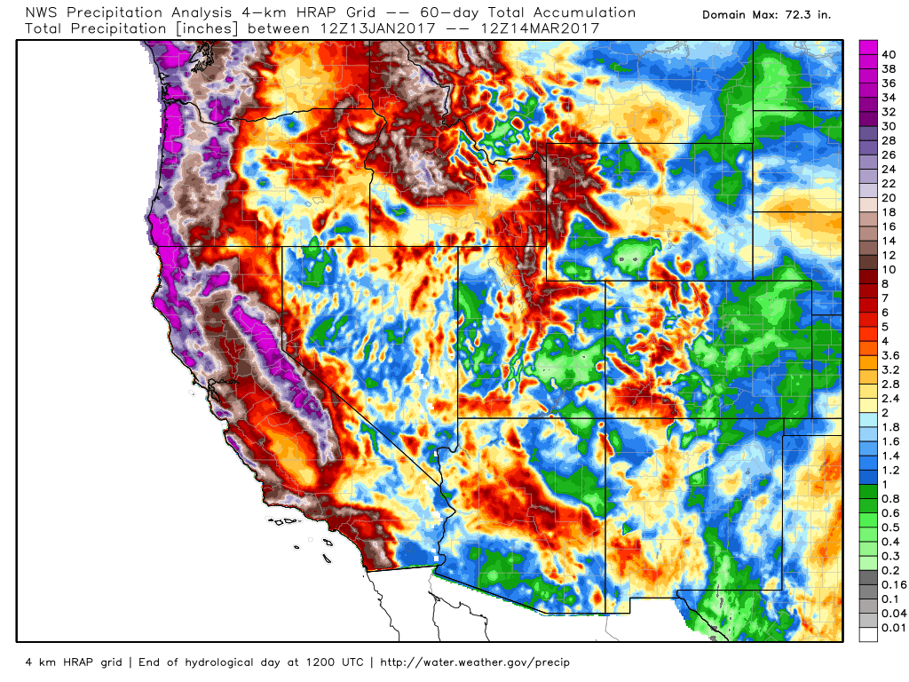
Last 60 Day Precipitation
If you're wondering how much precipitation has fallen across the Western US, here's the estimated precipitation over the last 60s days (roughly since mid January 2017). Note that the white and purple colors correlated with nearly 2ft to 3ft+ (liquid) seen in the legend on the right. Pretty impressive!
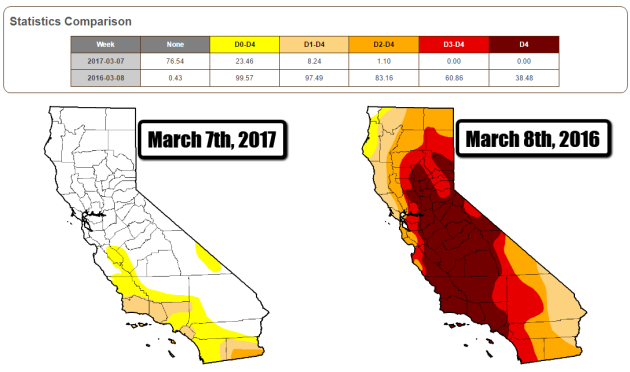
California Drought Comparison 2017 vs 2016
Take a look at the drought comparison from March 7th, 2017 vs March 8th, 2016. Note how much improvement we've seen across much of the state since last year! According to the US Drought Monitor, EXTREME and EXCEPTIONAL drought conditions do not exist anymore and there is only a little sliver of SEVERE drought across the extreme southeastern part of the state! Most of these improvements have occurred since the beginning of 2017!
________________________________________________________________________
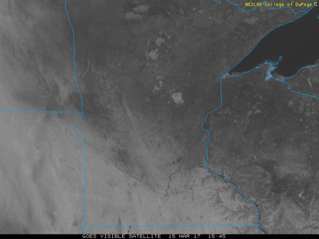
Visible Satellite on Wednesday
Here's the visible satellite loop from Wednesday, which showed mostly sunny skies across the region. Note the whiter coloring across the southern half of the state, this is from the recent heavy snow that fell Sunday into AM Monday. The Minnesota River Valley can be seen very plainly as well as the ice covered lakes of Mille Lacs, Leech and Upper/Low Red Lakes.The clouds moving in from the west are in association with the precipitation chance that will be building in later this week.
_____________________________________________________________________________
Gradual Warming Trend Continues. Light Rain Late Thursday
By Todd Nelson, filling in for Douglas.
By Todd Nelson, filling in for Douglas.
I'd have to say I am a little jealous of the Northeast after reading some of the latest snowfall reports. Sure, sure... I am probably in the minority, but hey, I like extremes! Widespread 1 to 2 feet snowfall amounts with some embedded 3 to 4 feet tallies buried parts of the New England States earlier this week. It came down hot and heavy with snowfall rates nearing 2 to 4 inches per hour. Good grief!
Our bright and chilly sunshine from Wednesday gives way to slightly warmer and slightly more unsettled weather through the end of the week. A fast moving clipper slides across the international border with a few light rain showers Thursday afternoon/evening. We shouldn't see much, but temperatures across the Arrowhead may be cold enough for shovelable snow through the end of the week.
A blustery wind develops St. Patty's Day Friday, but it doesn't look too chilly. The extended forecast suggests a chance of 50 degrees Sunday and for the first day of spring on Monday!
March is our 3rd snowiest month of the year. Winter isn't over yet.
___________________________________________________________________________
___________________________________________________________________________
Extended Forecast:
WEDNESDAY NIGHT: Partly cloudy and quiet. Not as cold. Winds: S 5. Low: 20
THURSDAY: Warmer. Few PM sprinkles/showers. Winds: SSE 5-10. High: 42
THURSDAY NIGHT: Mostly cloudy with a few light rain showers. Winds: SSE 5-10. Low: 33
FRIDAY: Breezy. Lingering sprinkles/flurries, mainly north. Winds: WNW 15-25. High: 47
SATURDAY: Hazy sun returns. Not as breezy. Winds: NW 5-15. Wake-up: 26. High: 44
SUNDAY: Warmer. Late day light rain possible. Winds: SSE 10-15. Wake-up: 29. High: 52
MONDAY: Skies clear. Still mild. Winds: NW 10-15. Wake-up: 34. High: 49
TUESDAY: A little cooler, looks dry. Winds: NW 5-15. Wake-up: 29. High: 42.
WEDNESDAY: Clouds thicken. Light mix late? Winds: ESE 5-15. Wake-up: 20. High: 40.
_______________________________________________________________________________
_______________________________________________________________________________
This Day in Weather History
March 16th
March 16th
1930: The temperature at the Minneapolis-St. Paul International Airport tops out at a record 71 degrees.
_______________________________________________________________________________
_______________________________________________________________________________
Average High/Low for Minneapolis
March 16th
March 16th
Average High: 41F (Record: 79F set in 2012)
Average: Low: 24F (Record: -10F set in 1900)
Average: Low: 24F (Record: -10F set in 1900)
*Record Snowfall: 9.0" set in 1917
_______________________________________________________________________________
_______________________________________________________________________________
Sunrise Sunset Times For Minneapolis
March 16th
March 16th
Sunrise: 7:23am
Sunset: 7:21pm
Sunset: 7:21pm
*Daylight Gained Since Yesterday: ~3 minutes & 9 seconds
*Daylight Gained Since Winter Solstice (December 21st): ~3 hours & 11 minutes
________________________________________________________________________________
*Daylight Gained Since Winter Solstice (December 21st): ~3 hours & 11 minutes
________________________________________________________________________________
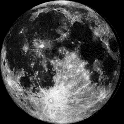
Moon Phase for March 15th at Midnight
2.7 Days After Full Worm Moon
2.7 Days After Full Worm Moon
________________________________________________________________________________
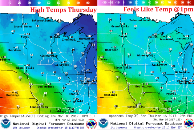
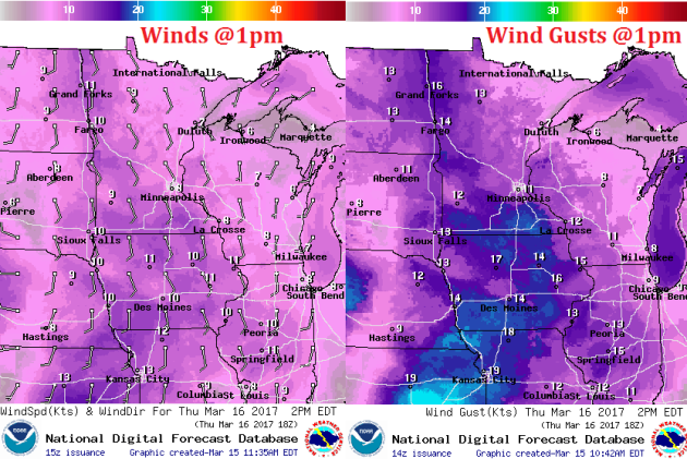
Weather Outlook For Thursday
High temperatures on Thursday will be a little warmer than they have been over the last several days with readings working into the 40s across much of the state by the afternoon. Winds will pick up a little during the day making it feel more like the 30s, but any snow that's left out there will certainly start melting.
Weather Outlook For Thursday
Winds on Thursday will be a little stronger than they were on Tuesday. However, they will be out of the south, which will help to bring in warmer temperatures across the region. By midday, winds could be gusting closer to 10-15mph with a few stronger gusts across the southern MN and across western MN.
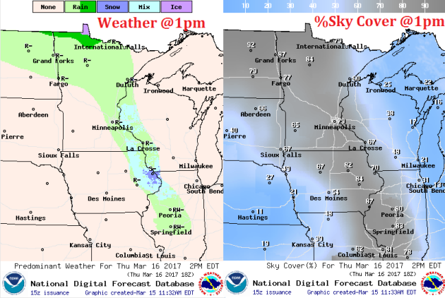
Late Week Clipper
A fast moving clipper system develops later this week with light rain changing to light snow from Thursday to Friday. Winds will also increase in the wake of the system on Friday with gusts approaching 30mph. The nice thing is that temperatures don't look to drop in the wake of the storm. In fact, we should see near steady temps with an increase in the temperature department to near 50F by Sunday!
.gif)
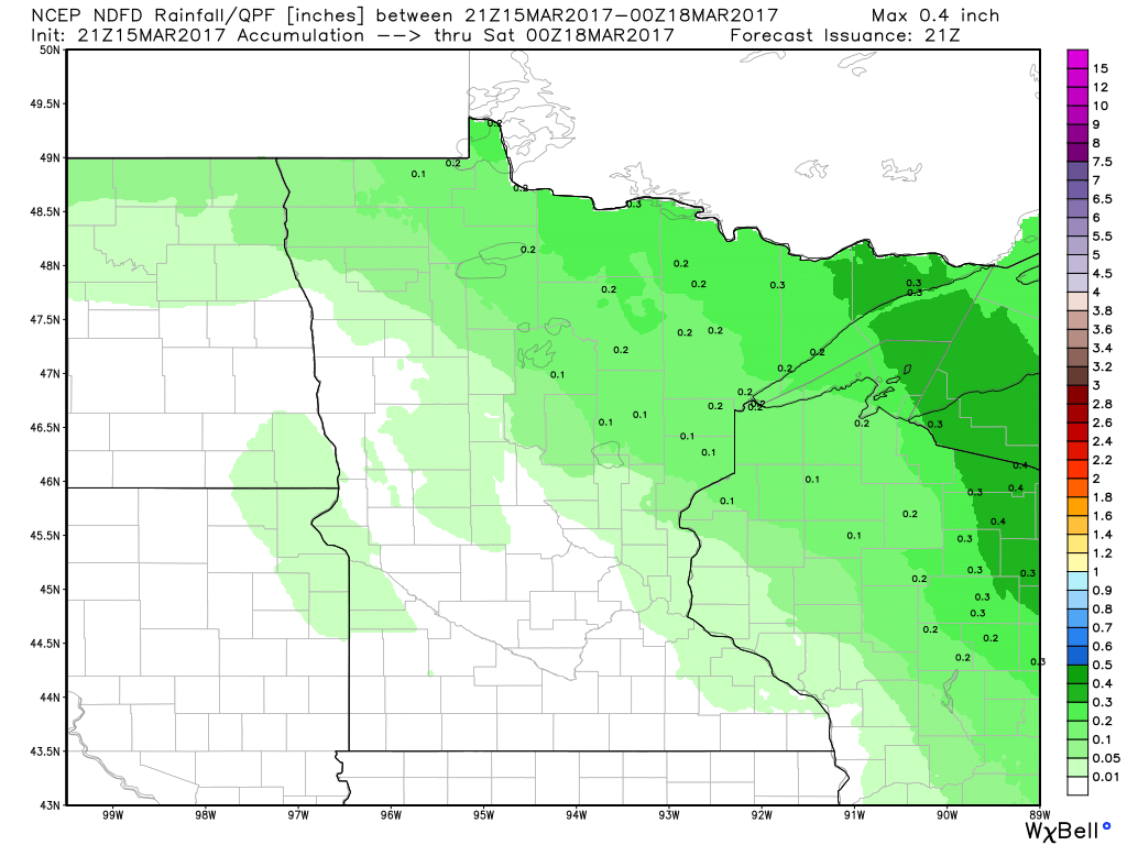
Precipitation Potential Thru Sunday
Our next fast moving clipper system rolls through the region by the end of the week with up to a few tenths of an inch of precipitation across the Arrowhead. Places around the Twin Cities may be lucky to see up to 0.1" liquid through PM Friday
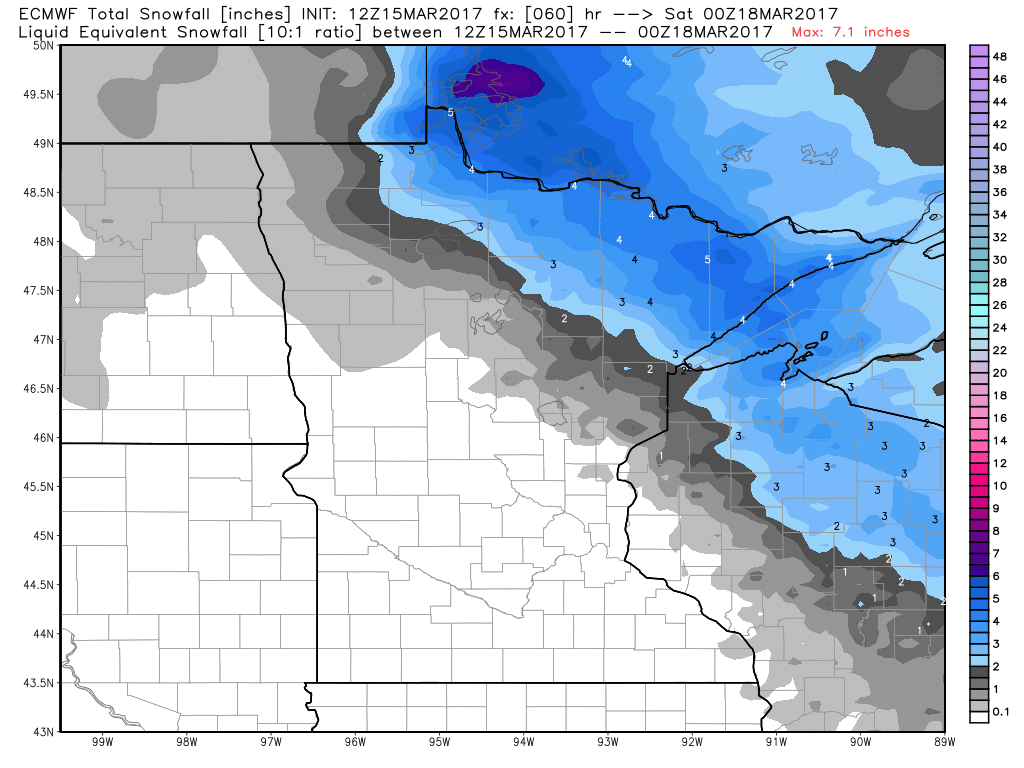
Snowfall Potential
The fast moving storm system may interact with enough cold air to produce a few inches of snow across the Arrowhead over the next few days. In fact, some of this snow could be shovelable!
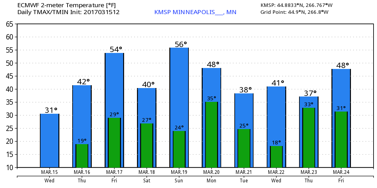
Extended Temperature Outlook for Minneapolis
Here's the temperature outlook through March 24th, which shows gradually warming temperatures through the end of the week with a few chances of hitting 50F around the weekend. The extended forecast shows readings falling back into the 30s late next week.
______________________________________________________________________________
______________________________________________________________________________
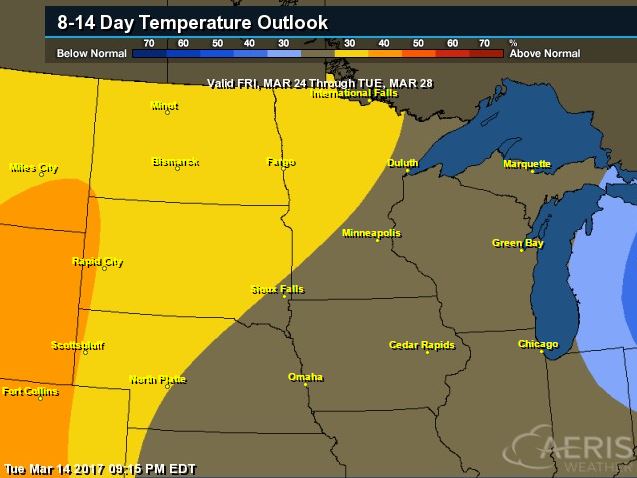
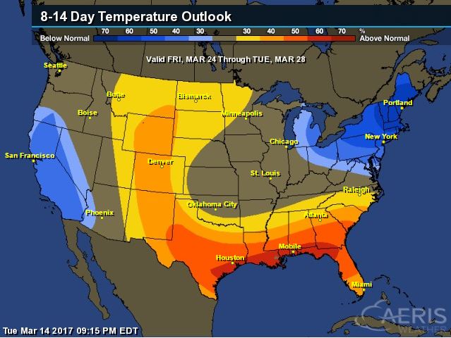
According to NOAA's CPC, the 8 to 14 day temperature outlook suggests warmer than average temperatures moving in across much of the Upper Midwest from March 24th - 28th. Note that the average high in the Twin Cities through the last week of March is typically in the mid to upper 40s, so if we do happen to get into above average temperatures, readings could be pushing 50F or better!
_________________________________________________________________________________
Temperature Outlook
 ________________________________________________________________________________
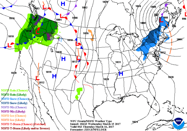
National Weather Outlook
Here's the national weather outlook through the end of the week, which shows the major Northeast storm fading on Thursday, while a system pushes through the Pacific Northwest and into the Midwest later this week. Meanwhile. Eventually this system will move into the Northeast with another round of rain/snow.
_____________________________________________________________________
Waves of Pacific Moisture in the Northwest
More rounds of heavier Pacific moisture will continue to push into the Northwest over the next few days with heavier rain along the coast and some mountain snow.
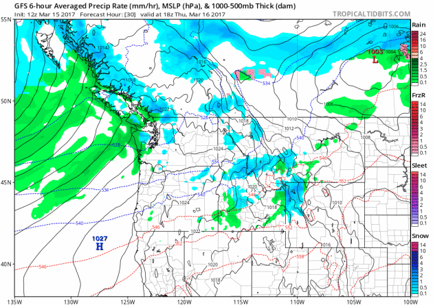
Precipitation in the Northwest
The precipitation potential through PM Tuesday suggests that another 2" to 4"+ liquid may be possible across the region. Note that some of the heavier tallies look to be along the coast and in the higher elevations. Flood concerns may come into play here as snow melt and rainfall ramps up.
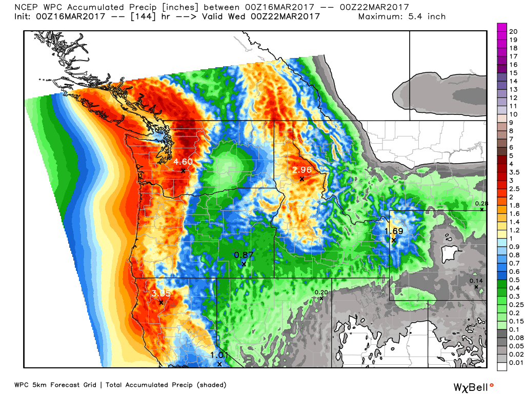
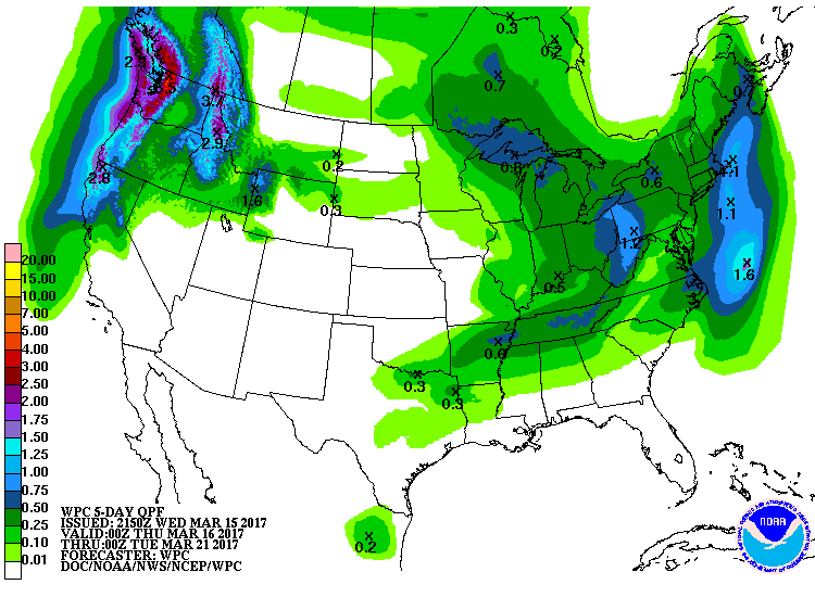
5 Day Precipitation Forecast
According to NOAA's WPC, the 5 day precipitation forecast suggests widespread 3" to 6"+ precipitation amounts across parts of the Pacific Northwest. Meanwhile, heavy precipitation will wrap up in the Northeast through the midweek time frame with another surge of moisture moving in late week and weekend ahead.
_____________________________________________________________________________
_____________________________________________________________________________
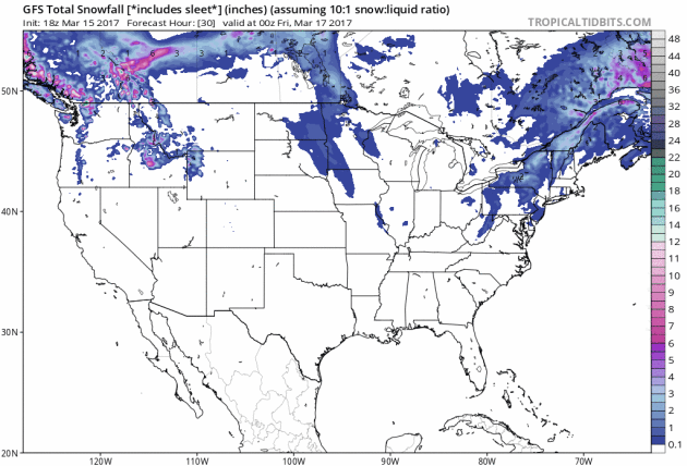
Here's the snowfall potential through the end of next weekend, which shows heavy snow finally wrapping up in the Northeast, but another round of snow looks to move through parts of the Great Lakes and into the Northeast by late week and weekend ahead.

 _________________________________________________________________________
_____________________________________________________________________
"Health And Climate Change: An Urgent Need For Action"
"The human face of climate change is its impact on our health. Higher temperatures intensify air pollution and respiratory illness. Changing weather patterns lead to drought and then famine, while increasing rains in other areas will create the breeding ground for disease and pandemics. While the policy changes needed to blunt climate change are surely substantial, the cost of ignoring the science behind climate change will be felt through its harmful effects on our health. Recently, the CDC canceled its Climate and Health Summit out of fear of retribution from the Trump administration. Working with Al Gore and others, Harvard worked to revive the meeting, which was held in Atlanta on February 16. This meeting reminded us that universities have a unique responsibility that we ensure a platform for key scientific issues that have a meaningful effect on people’s health. Climate change is one such critical issue."
(BRAZIL PHOTOS VIA GETTY IMAGES and HuffingtonPost.com)
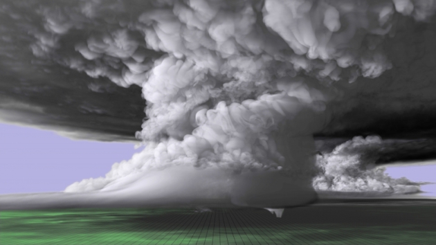
"A scientist and a supercomputer re-create a tornado"
WOW! This is fantastic. Have you ever wanted to see a supercell thunderstorm and an EF-5 tornado? Check out this impressive computer generated tornado. Here's an excerpt from news.wisc.edu: "With tornado season fast approaching or already underway in vulnerable states throughout the U.S., new supercomputer simulations are giving meteorologists unprecedented insight into the structure of monstrous thunderstorms and tornadoes. One such recent simulation recreates a tornado-producing supercell thunderstorm that left a path of destruction over the central Great Plains in 2011."
(A colorized image of the tornado-producing supercell nearly 20 miles long and 12 miles high. The imagery from the simulation was built upon real world data collected near the May 24, 2011 supercell, which spawned several tornadoes including the EF-5 that touched down near El Reno and Oklahoma City, Oklahoma.)
"The slippery slope of climate change"
“We know that the impacts of increases in temperature, floods and sea-level rise trickle down within and across sectors affecting people, assets and our social and economic interactions,” says Dr Lawrence. “And as these changes become more frequent, like heavy rainfall, and as the sea-levels rise and the effects increase from storm surges, we’re going to have less time to recover from them—which will also have cumulative consequences. “We need to make sure that we’re thinking about the interconnections. The impacts themselves cascade, but policy responses can also cascade if the interconnections are not factored in.”
See more from Victoria University of Wellington HERE:
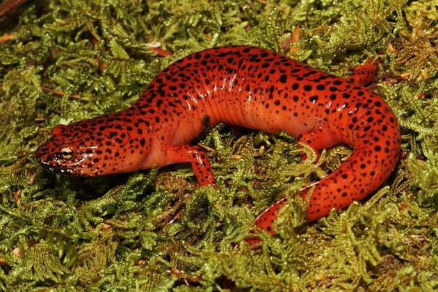
 __________________________________________________________________________"Penn State researchers study salamanders to learn about climate change"
"Researchers at Penn State have taken a unique approach to climate change studies by studying its effects on salamanders, specifically the red-backed salamander. Like all amphibians, salamanders breathe through their skin, which means they require specific habitat conditions in order to survive making them a good choice to study the effects of climate change. Furthermore, the red-backed salamander is the most abundant species in the eastern United States, which means they contribute a large amount of biomass to the environment and can serve as an indicator of forest health. “One of the things we are interested in figuring out is, do they have any evidence of being locally adapted to the climate changes they experience across the range,” Muñoz said. For example, if the salamanders in Virginia are warm-adapted compared to those in Canada, it might be beneficial to introduce those genes to the Canadian populations when considering management options."
See more from the Daily Collegian HERE:
 ______________________________________________________________________________
_______________________________________________________________________________

______________________________________________________________________________
 _____________________________________________________________________________
See more from Victoria University of Wellington HERE:
"Researchers at Penn State have taken a unique approach to climate change studies by studying its effects on salamanders, specifically the red-backed salamander. Like all amphibians, salamanders breathe through their skin, which means they require specific habitat conditions in order to survive making them a good choice to study the effects of climate change. Furthermore, the red-backed salamander is the most abundant species in the eastern United States, which means they contribute a large amount of biomass to the environment and can serve as an indicator of forest health. “One of the things we are interested in figuring out is, do they have any evidence of being locally adapted to the climate changes they experience across the range,” Muñoz said. For example, if the salamanders in Virginia are warm-adapted compared to those in Canada, it might be beneficial to introduce those genes to the Canadian populations when considering management options."
See more from the Daily Collegian HERE:
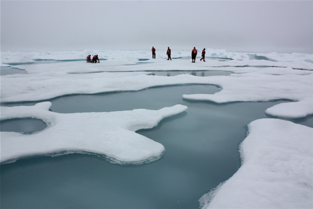
"Arctic Sea Ice May Vanish Even With Climate Goal"
Arctic sea ice may vanish in summers this century even if governments achieve a core target for limiting global warming set by almost 200 nations in 2015, scientists said this week. Arctic sea ice has been shrinking steadily in recent decades, damaging the livelihoods of indigenous peoples and wildlife such as polar bears while opening the region to more shipping and oil and gas exploration. Under the 2015 Paris Agreement, governments set a goal of limiting the rise in average world temperatures to well below 2°C (3.6°F) above pre-industrial times, with an aspiration of just 1.5°C (2.7°F).
(Arctic sea ice and melt ponds in the Chukchi Sea. Credit: NASA/Kathryn Hansen)
_______________________________________________________________________________
"‘Fast radio bursts’ from space might be from aliens, scientists report"
"Astronomers revealed last January the existence of a mysterious type of radio waves coming from space. After studying it closely, they are saying that humans might not be alone in the universe after all. Identified as fast radio bursts (FRBs), astrophysicists from the Harvard-Smithsonian Center for Astrophysics and, Manasvi Lingam at Harvard University, are hinting at a possibility that the waves are coming from alien technological origin."
(An artist’s illustration of the mysterious FRBs. Image: M. Weiss/Center for Astrophysics website)
______________________________________________________________________________
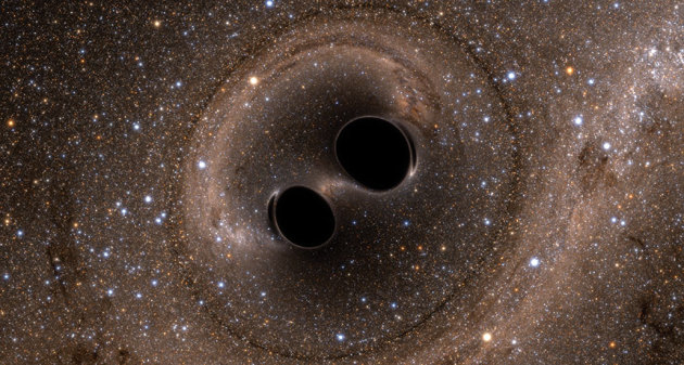
"Gravity waves from black holes verify Einstein’s prediction"
Albert Einstein was pretty brilliant man. He discovered and predicted many things, but how about this? Here's an excerpt from ScienceNews.org: "Albert Einstein predicted gravitational waves in 1916, and researchers finally detected them 100 years later."
(SWEET SUCCESS For the first time, physicists have directly observed gravitational waves, caused by two black holes colliding)
Thanks for checking in and don't forget to follow me on Twitter @TNelsonWX

No comments:
Post a Comment