Visible Satellite on Friday
Friday wasn't very green. In fact, it was pretty gray! A storm system rolled across the northern part of the state with scattered rain/snow showers across the far north. Wrap around clouds settled in across the southern half of the state as winds picked up during the late afternoon hours. The good news is that the clouds and gusty winds will move out as we head into the early part of the weekend.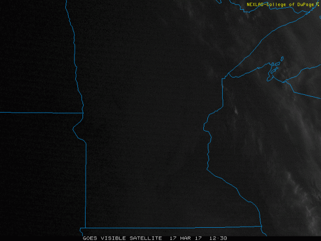
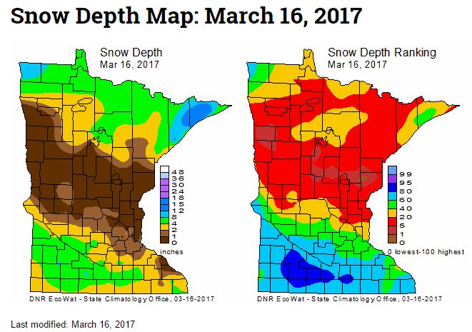
Minnesota Snow Depth Ranking
Here's the latest snow depth ranking from the MN DNR, which was released on Thursday, March 16th. Note that much of central Minnesota is snow free, while parts of northern and southern Minnesota still have some snow on the ground.
__________________________________________________________________________
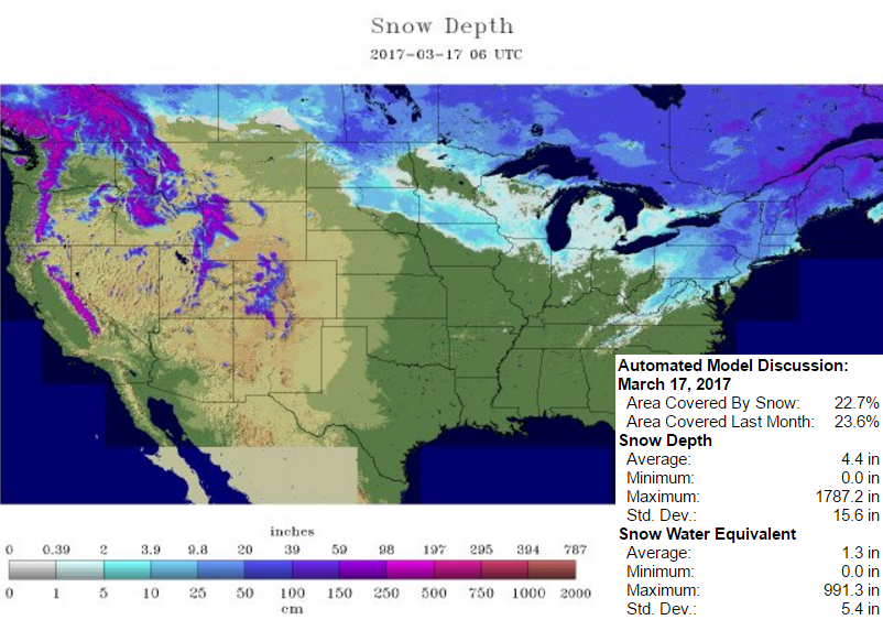
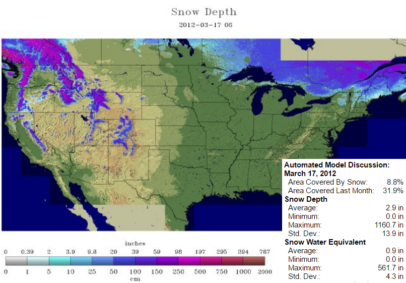
National Snow Depth 2017 vs 2012
According to NOAA's NOHRSC, the national coverage as of March 17th was nearly 23%. Note the widespread snow across the Northeast from the recent heavy snowfall event there and also note the heavy mountain snow across in the West! Comparing the snow coverage from 2017 to 2012, you can see that only 9% of the nation was covered 5 years ago at this time. If you recall, March 2012 was an extremely warm month across the Central part of the country. It hit 80F in the Twin Cities on St. Patty's Day that year!
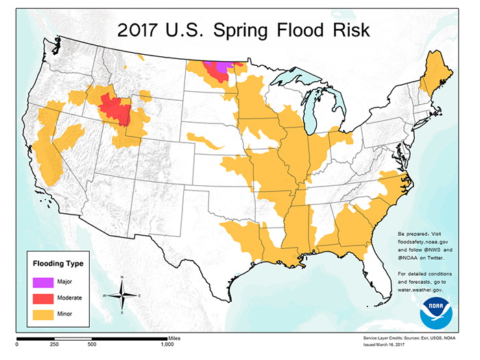
On Thursday, March 16th, NOAA released their 2017 Spring Flood Risk and it showed major flood concerns across parts of North Dakota. Here's an excerpt from NOAA: "Northern North Dakota – the Souris River, Devils Lake and the northernmost reaches of the Red River – has the greatest risk of major flooding this spring, while moderate flooding is possible over southern Idaho in the Snake River basin, according to NOAA’s Spring Outlook released today. California, which saw extensive flooding in February, is susceptible to additional flooding from possible storms through the remainder of the wet season and later, from snowmelt."
See more from NOAA HERE:
__________________________________________________________________________
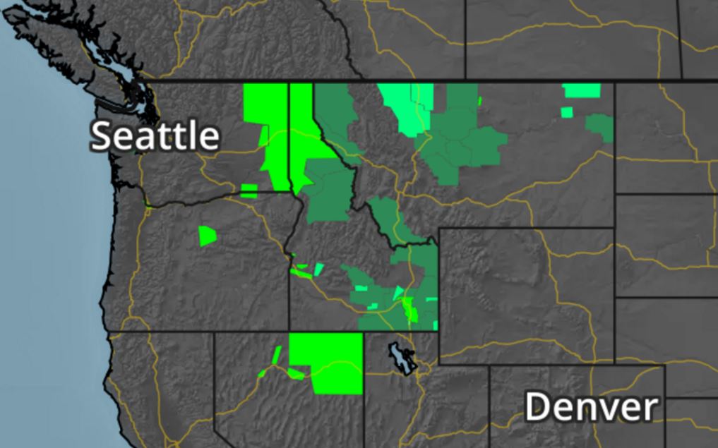
Flood Concerns Continue in the Northwest
A number of flood concerns have been posted across the Northwest do to the combination of snow melt and rainfall. A number of rivers, streams and creeks will be elevated over the next several days due to the weather conditions there.
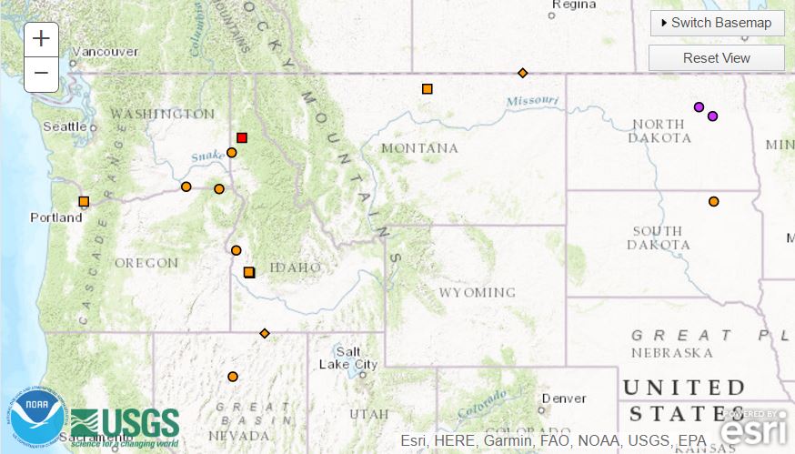
River Flooding Concerns
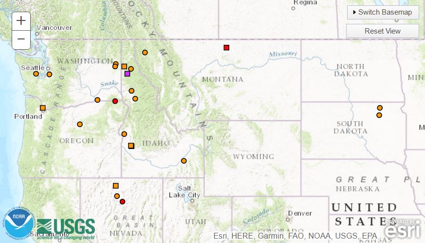
According to NOAA's NWS, there are currently 20 river guages that are currently in flood stage and the extended forecast suggesting that 26 river guages will be in flood stage through the end of next week.
NOAA: Current River Gauges in Flood Stage
NOAA: Forecast For River Gauges that will be in Flood Stage Through Friday, March 24th
_________________________________________________________________________
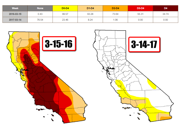
California Drought Comparison 2017 vs 2016
Take a look at the drought comparison from March 15th, 2016 vs March 14th, 2017. Note how much improvement we've seen across much of the state since last year! According to the US Drought Monitor, EXTREME and EXCEPTIONAL drought conditions do not exist anymore and there is only a little sliver of SEVERE drought across the extreme southeastern part of the state! Most of these improvements have occurred since the beginning of 2017!
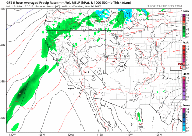
More Rain in California Next Week
Here's the weather outlook from Sunday to Thursday, which shows another round of precipitation working into the Western US with some fairly decent precipitation tallies. Note that rain will be found in the lower elevations, while areas of heavier snow may be found in the higher elevations.
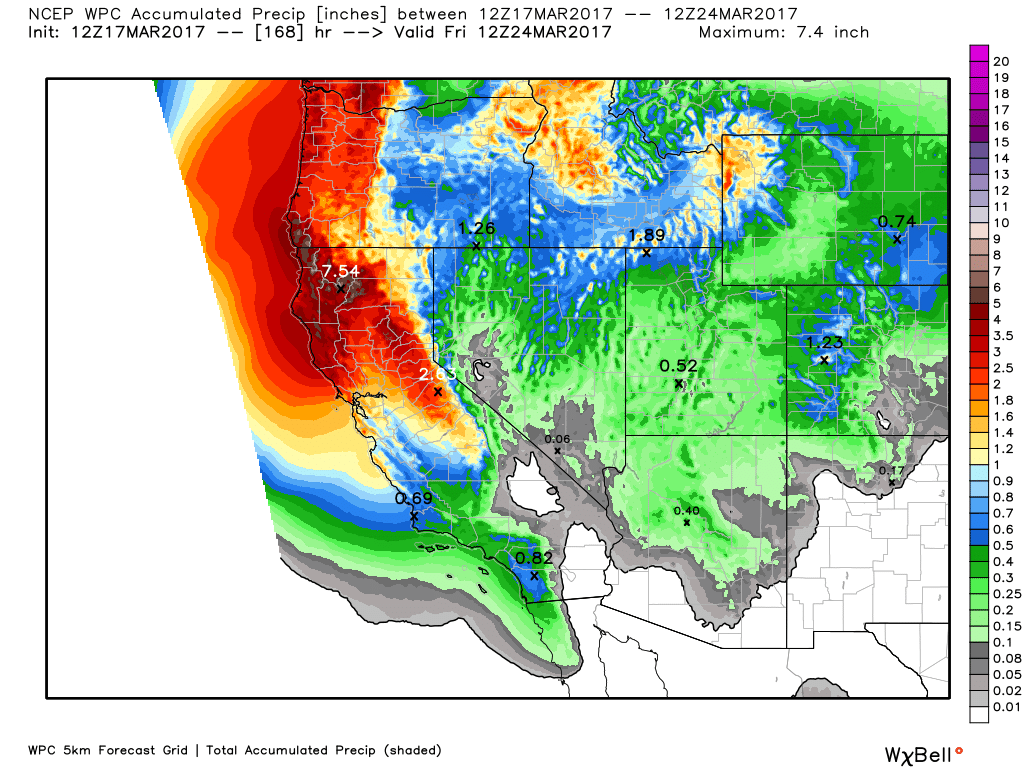
Western Precipitation Potential
Here's a look at the precipitation potential through late next week, which shows another round of heavy precipitation moving through the Western US. Some spots could see as much as 3" to 6"+ of liquid.
____________________________________________________________________________
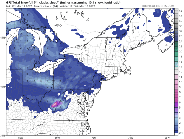
Here's the simulated radar from Saturday to Sunday, which shows a another storm system moving into the region. While this storm is nothing like the storm earlier this week, it will still have the capability of bringing some additional snowfall accumulations to parts of the region.
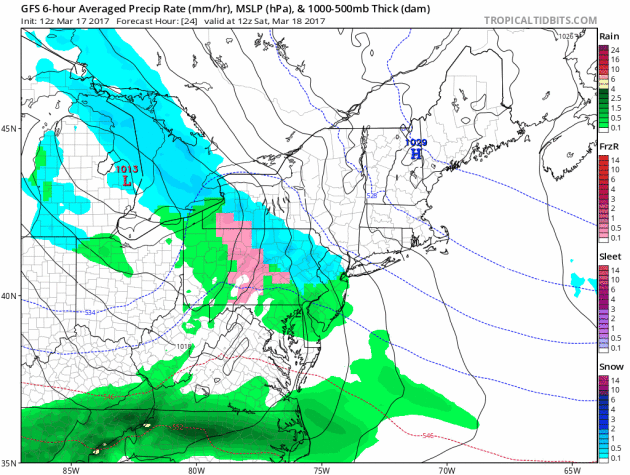
More Snow in the Northeast?
As our next storm system moves into the Northeast, additional snowfall will be possible. While snowfall amounts don't look nearly as heavy as they did earlier this week, some spots could see some shovelable amounts.
___________________________________________________________________________
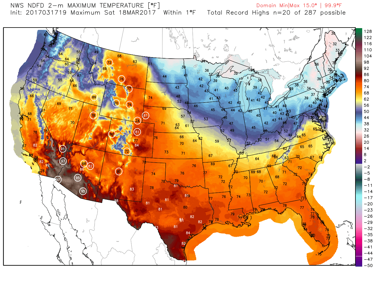
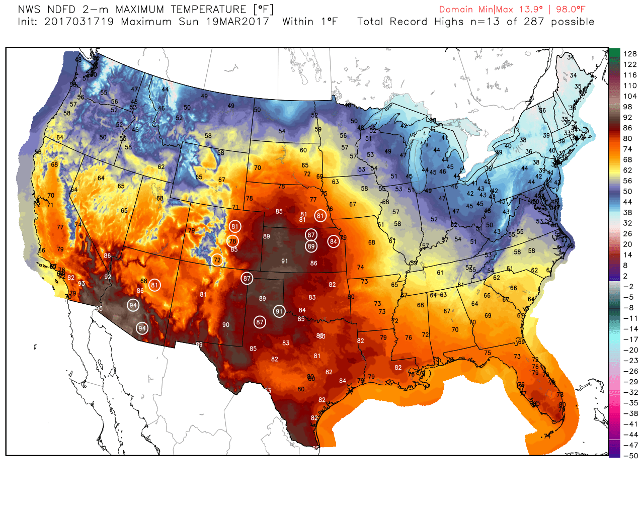
Record Weekend Warmth
Here's a look at the potential record highs that could be set on Saturday and Sunday respectively. Note that record highs on Saturday could be found as far north as Montana and then on Sunday, record warmth will be fairly widespread across the Plains on Sunday.
_______________________________________________________________________
Mild Weekend on Tap. Rain/Snow Mix By Friday?
fdBy Todd Nelson, filling in for Douglas.
fdBy Todd Nelson, filling in for Douglas.
Welcome to your last official weekend of winter 2017. The sun's most direct rays will shine directly over the equator on Monday, marking the start of spring in the northern hemisphere. This winter was kind of a dud, no question. Get this, the Twin Cities has only seen 31.5 inches of snow this season, which is nearly 17 inches below normal. Earlier this week, Binghamton, NY picked up 31.3 inches of snow in a 24 hour period, making it the snowiest 24 hours on record for that city! It has taken nearly 7 months for the Twin Cities to achieve what Binghamton picked up in just 1 days time. Good grief.
No accumulating snow in the forecast this weekend. Saturday will feature sunny skies with highs in the 40s. A breezy south wind develops Sunday, which will help push temperatures up close to 60 degrees for a few locations in southern Minnesota. Clouds will then thicken late with a few light rain showers by the evening.
The week ahead starts quiet, but a storm looms late week with a chance of rain & snow. Twins' Home Opener is in 2.5 weeks!
___________________________________________________________________________
___________________________________________________________________________
Extended Forecast:
FRIDAY NIGHT: Mostly cloudy, still breezy. Winds: WNW 15-25. Low: 27.
SATURDAY: Sunny. Near average temps and not as breezy. Winds: NW 5-15. High: 43
SATURDAY NIGHT: Partly cloudy and quiet. Winds: SE 5. Low: 31.
SUNDAY: Mild and breezy. Few showers late. Winds: SSW 10-15. High: 58
MONDAY: Sun returns. Still mild. Winds: NW 10-15. Wake-up: 35. High: 50
TUESDAY: Mostly sunny. Feeling cooler. Winds: NNE 5-10. Wake-up: 26. High: 40.
WEDNESDAY: Clouds thicken. Light mix overnight? Winds: SE 10-15. Wake-up: 20. High: 43.
THURSDAY: Mostly cloudy. Steady rain develops. Winds: SSE 10-20. Wake-up: 30. High: 45.
FRIDAY: Breezy. Rain/snow mix. Winds: NNW 10-20. Wake-up: 30. High: 46.
_______________________________________________________________________________
_______________________________________________________________________________
This Day in Weather History
March 18th
March 18th
1968: (Previous to this year's tornadoes on March 6th) the earliest tornado hit Minnesota. No one was hurt when it hit Watonwan County.
_______________________________________________________________________________
_______________________________________________________________________________
Average High/Low for Minneapolis
March 18th
March 18th
Average High: 42F (Record: 79F set in 2012)
Average: Low: 25F (Record: -8F set in 1923)
Average: Low: 25F (Record: -8F set in 1923)
*Record Snowfall: 9.6" set in 1951
_______________________________________________________________________________
_______________________________________________________________________________
Sunrise Sunset Times For Minneapolis
March 18th
March 18th
Sunrise: 7:19am
Sunset: 7:23pm
Sunset: 7:23pm
*Daylight Gained Since Yesterday: ~3 minutes & 9 seconds
*Daylight Gained Since Winter Solstice (December 21st): ~3 hours & 17 minutes
________________________________________________________________________________
*Daylight Gained Since Winter Solstice (December 21st): ~3 hours & 17 minutes
________________________________________________________________________________
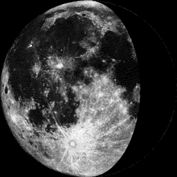
Moon Phase for March 17th at Midnight
2.4 Days Before Last Quarter
2.4 Days Before Last Quarter
________________________________________________________________________________
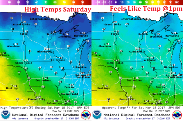
Weather Outlook For Saturday
High temperatures on Saturday will be a little cooler than we were on Friday, but still fairly mild for mid March. Readings across the state will range form the 40s across the southern half of the state to the 30s across the northern part of the state. Feels like temperatures around midday will be a little cooler, but the wind won't be quite as gusty as it was Friday afternoon.
Weather Outlook For Saturday
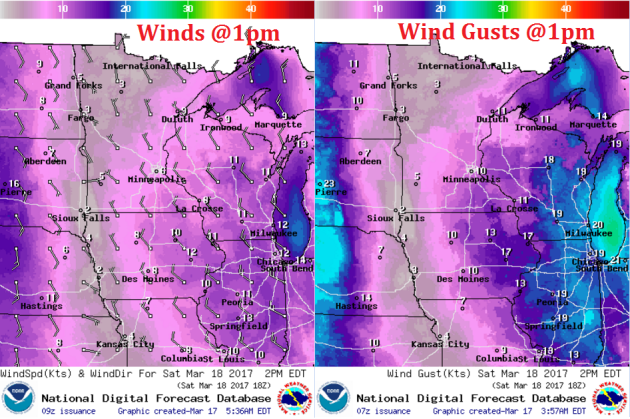
Here's a look at winds around the region on Saturday. Note that winds won't be nearly as strong as they were PM Friday. In fact, winds will continue to fade throughout the day.
After a mostly cloudy Friday, the sun returns for much of the day Saturday. Low clouds and areas of light precipitation will move into the Great Lakes Regions, while a few high clouds will drift into the region late in the day.