A Real Sharknado?
Talk about weird... How would you like to wake up to a bull shark sitting in your front yard? It wasn't really a sharknado, but a powerful cyclone hit parts of Australia earlier this week, which led to flooding across the region. After the floodwaters receeded a bit, this bull shark was spotted in someones front yard. YIKES! Here's an excerpt from NYDailyNews: "Cyclone Debbie brings Australia floodwater and bull sharks, some residents ignore dangers and enter saturated streets. A powerful Category 3 cyclone hit Queensland, Australia, this week, some Australians did not heed advice from officials to avoid floodwaters. Despite a warning from Australian emergency services, photos and videos were posted on social media of locals making use of the floodwaters — surfing, boogie boarding, kayaking and jumping on rain-soaked trampolines. The situation was “dampened” even further, however, when Queensland Fire and Emergency tweeted out photos of a large bull shark that washed up in the floodwaters. The tweet reads, “Think it’s safe to go back in the water? Think again! A bull shark washed up in Ayr. Stay out of floodwater. #TCDebbie #ifitsfloodedforgetit.”"
(This March 30, 2017 image shows a bull shark that was found in a puddle near the town of Ayr, located south of Townsville, following flooding in the area from heavy rains associated with Cyclone Debbie in Australia. (HANDOUT/REUTERS))

A Tumble Weed Traffic Jam?
While snow tends to create white-kuckle driving issues across the north, it appears that tumble weeds are cause for concern in the south! Check out this story from ABC7: Powerful winds wreaked havoc throughout the Southland on Thursday, knocking out power, capsizing a boat and creating a tumbleweed traffic jam. Several high wind watches and warnings were in effect from 9 p.m. Thursday through Friday morning in different parts of Southern California, including the Santa Clarita and Antelope valleys, as well as areas in the Inland Empire and Los Angeles County mountains. The extreme weather led to thousands of reported power outages believed to be wind-related. According to Socal Edison, 7,700 customers were without power across the region, most of them likely due to the strong wind conditions. The hardest hit was an unincorporated area of San Bernardino, which had 1,607 customers without power. Riverside had 1,086 customers without power.

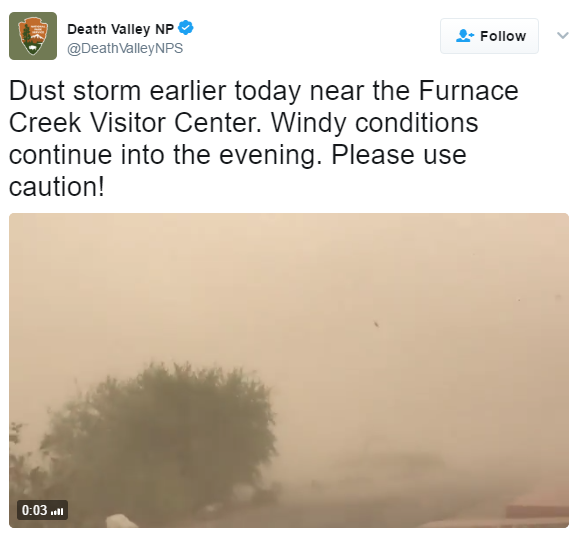
Death Valley Dust Storm!
The same storm system that will be responsible for strong to severe thunderstorms across the Southern US this weekend was responsible for strong winds across the Southwest earlier this week. Take a look at the dust storm that developed in Death Valley National Park on Thursday! WOW!
___________________________________________________________________________
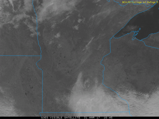
Visible Satellite on Friday
Despite a few stubborn clouds across parts of central and southern Minnesota early in the morning, Friday turned out to be pretty amazing! Sunshine and mild temperatures made for a very nice day across the region.
 ___________________________________________________________________________
 _____________________________________________________________________
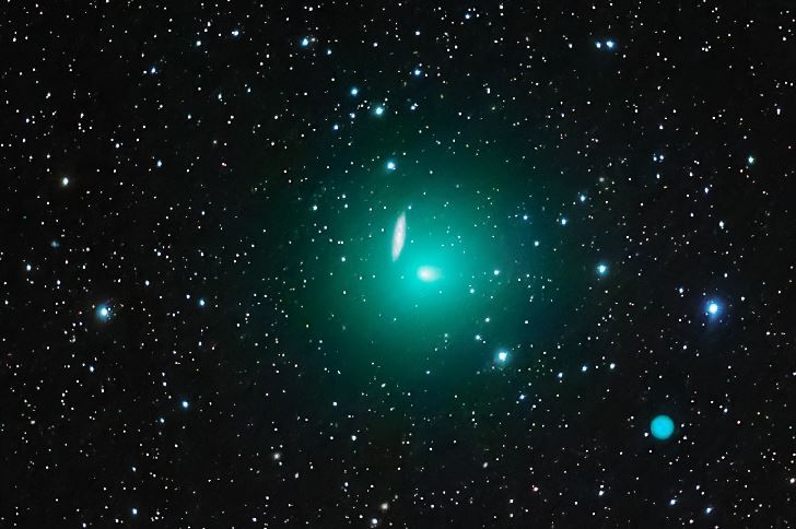
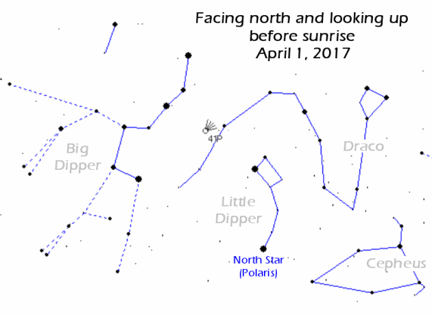
April 1st Comet Flyby!
Green comet 41P/Tuttle-Giacobini-Kresak is flying over Earth's North Pole this week where sky watchers can find it all night long not far from the bowl of the Big Dipper. At closest approach on April 1st it will be just 21 million km from Earth--an easy target for backyard telescopes and almost visible to the naked eye. This is not a Great Comet, but it should be a good one. The best time to observe is during the dark hours before sunrise when the green fuzzball is high in the northern sky. If you have a GOTO telescope, you can point it using an ephemeris from the Minor Planet Center.
See more from Spaceweather HERE:
(Taken by Yasushi Aoshima on March 22, 2017 @ Fukushima, JAPAN via Spaceweather.com)
_________________________________________________________________________
 ___________________________________________________________________________
 ____________________________________________________________________________
______________________________________________________________________
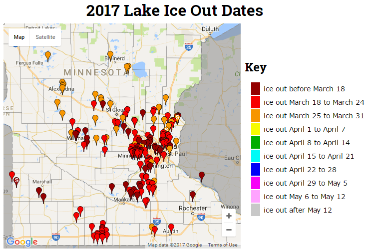
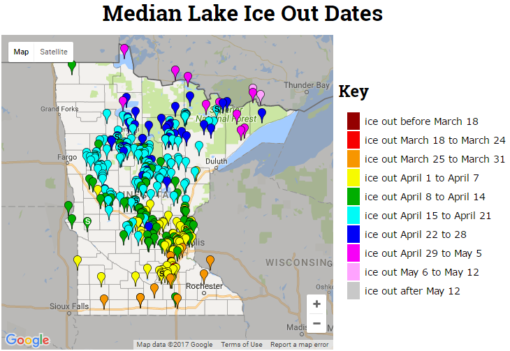
2017 Ice Out Dates
Here's the latest MN DNR ice out dates, which shows that more lakes across Central MN have officially gone out for the season. Note that ice outs are occuring nearly 1 to 2 weeks ahead of schedule this year!
April 1st Comet Flyby!
Green comet 41P/Tuttle-Giacobini-Kresak is flying over Earth's North Pole this week where sky watchers can find it all night long not far from the bowl of the Big Dipper. At closest approach on April 1st it will be just 21 million km from Earth--an easy target for backyard telescopes and almost visible to the naked eye. This is not a Great Comet, but it should be a good one. The best time to observe is during the dark hours before sunrise when the green fuzzball is high in the northern sky. If you have a GOTO telescope, you can point it using an ephemeris from the Minor Planet Center.
See more from Spaceweather HERE:
(Taken by Yasushi Aoshima on March 22, 2017 @ Fukushima, JAPAN via Spaceweather.com)
_________________________________________________________________________
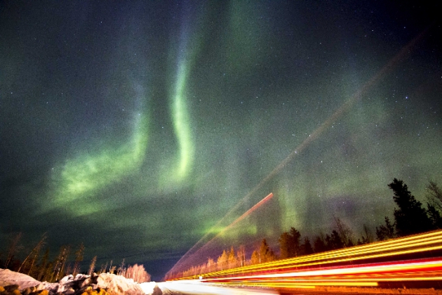
Solar Wind Continues to Blow
If you've keeping up to date with latest northern lights forecasts and were lucky enough to venture out at the right time with the right weather conditions, you may have had a chance to see the illusive northern lights this week! Here's an excerpt from Spaceweather.com regarding the most recent storm: "Minor G1-class geomagnetic storms are circling Earth's poles as our planet spends its 5th day inside a fast-moving stream of solar wind. Arctic and Antarctic sky watchers should remain alert for auroras after local nightfall"
(Image courtesy: Sònia i Joan on March 31, 2017 @ Kabdalis, Swedish Lapland via Spaceweather)
Northern Lights Potential Continues...
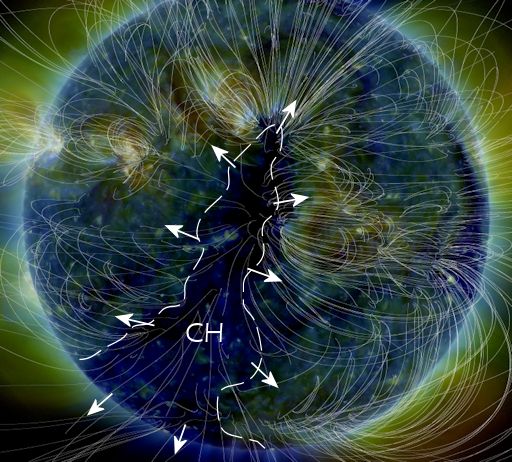
Due to an Earth-facing storm on the sun, northern lights have been quite this week! Here's an excerpt from spaceweather.com from a few days ago, which detailed why northern lights have been so active this week: POTENT CORONAL HOLE FACES EARTH: A canyon-shaped hole in the sun's atmosphere is facing Earth, and it is spewing a stream of fast-moving solar wind toward our planet. NASA's Solar Dynamics Observatory photographed the giant fissure on March 25th: This is a "coronal hole" (CH) -- a vast region where the sun's magnetic field opens up and allows solar wind to escape. A gaseous stream flowing from this coronal hole is expected to reach our planet on during the late hours of March 27th and could spark moderately-strong G2-class geomagnetic storms around the poles on March 28th or 29th. We've seen this coronal hole before. In early March, it lashed Earth's magnetic field with a fast-moving stream that sparked several consecutive days of intense auroras around the poles. The coronal hole is potent because it is spewing solar wind threaded with "negative polarity" magnetic fields. Such fields do a good job connecting to Earth's magnetosphere and energizing geomagnetic storms. Arctic sky watchers should be alert for auroras!
Northern Lights Potential Continues on Friday, March 31st & Saturday, April 1st
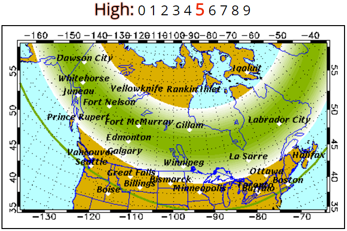
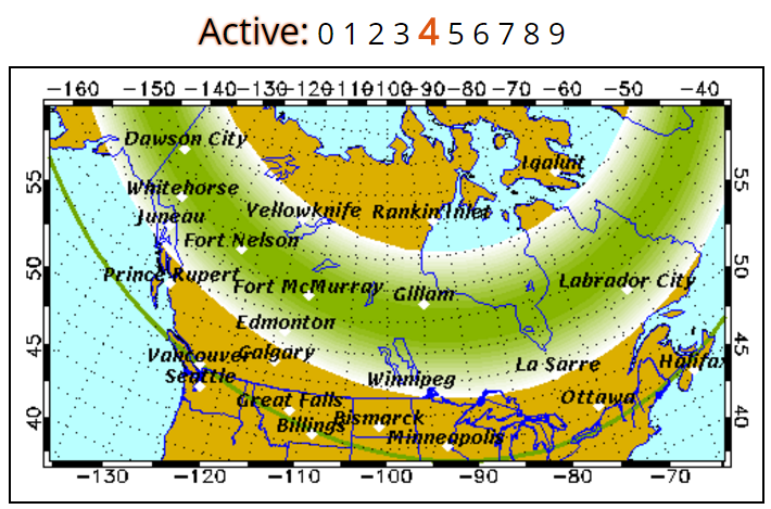
According to the Geophysical Institute at the University of Alaska Fairbanks, the northern lights potential is HIGH for Friday, March 31st and ACTIVE for Saturday, April 1st! Here's their forecast below:
Friday, March 31st: Auroral activity will be HIGH. Weather permitting, highly active auroral displays will be visible overhead from Inuvik, Yellowknife, Rankin and Igaluit to Juneau, Edmonton, Winnipeg, Thunder Bay and Sept-Iles, and visible low on the horizon from Seattle, Des Moines, Chicago, Cleveland, Boston, and Halifax.
Saturday, April 1st: Forecast: Auroral activity will be active. Weather permitting, active auroral displays will be visible overhead from Inuvik, Yellowknife, Rankin and Igaluit to Juneau, Edmonton, Winnipeg and Sept-Iles, and visible low on the horizon from Vancouver, Great Falls, Pierre, Madison, Lansing, Ottawa, Portland and St. Johns.
______________________________________________________________________
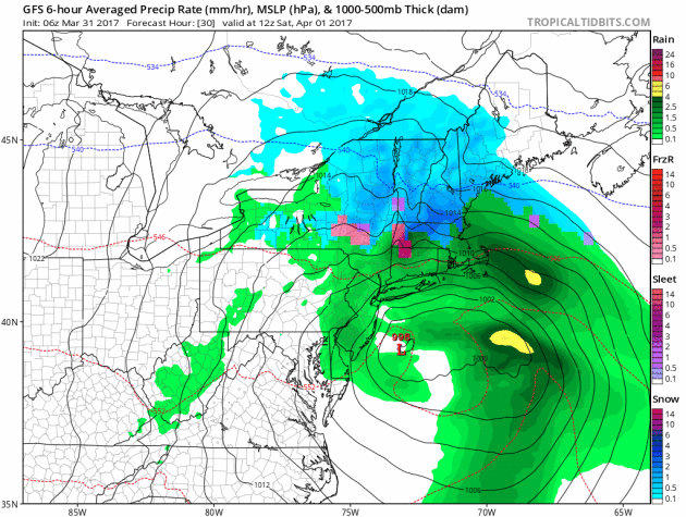
Weather conditions across the country will remain quite active through the weekend and early next week across the Southern US as Pacific storms continue to slide across the country. These storms have been responsible for fairly impressive precipitation amounts in the Western US, including heavy snow in the higher elevations. As they move into the Plains, they become severe weather makers, which has been an ongoing situation since the beginning of the week. Here's the simulated radar through early next week, which shows additional storm systems pushing across the country with more high elevation snow and strong to severe thunderstorm potential.
.gif)
Several Weather Threats Ahead
According to NOAA's SPC, the risk of severe weather continues right through the weekend and potentially into early next week. The images below are the severe threats on Saturday and Sunday respectively. In these particular areas, large hail, damaging winds, isolated tornadoes and locally heavy rainfall will all be possible.
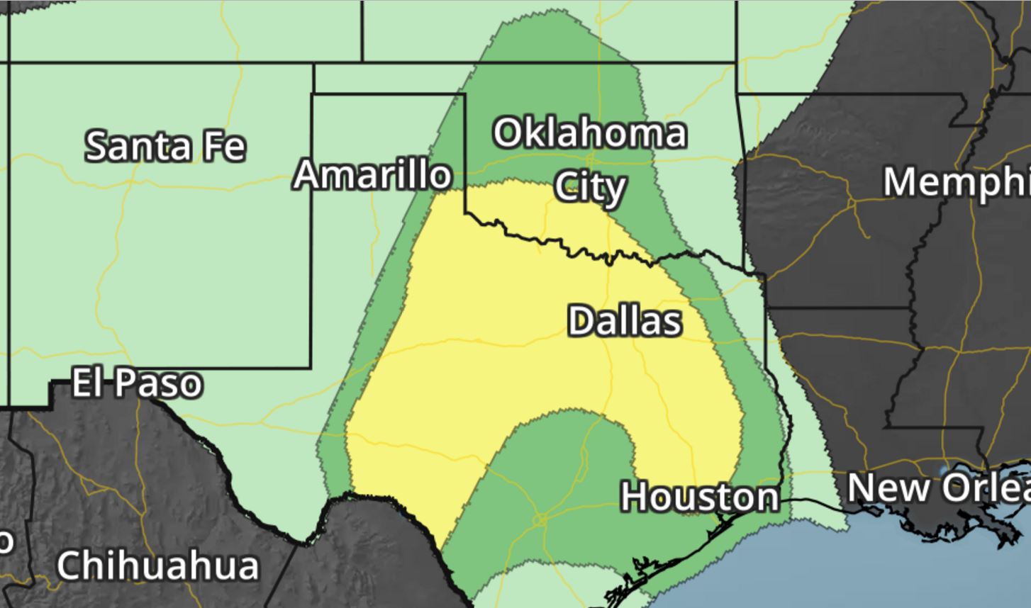
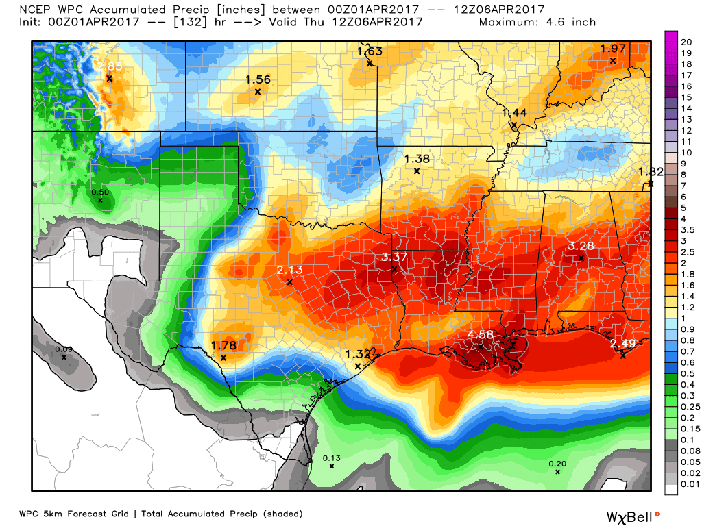
Southern Rainfall Potential
_________________________________________________________________________
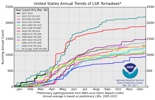
2017 PRELIMINARY Tornado Count
According to NOAA's SPC, the PRELIMINARY tornado count for 2017 is at 423 (thru March 30). Interestingly, this is the highest number of tornado reports (thru March 30th) since 2012 when nearly 500 tornadoes were reported through that time frame. The 2005-2015 average number of tornado reports through March 30th is 219.
 ________________________________________________________________
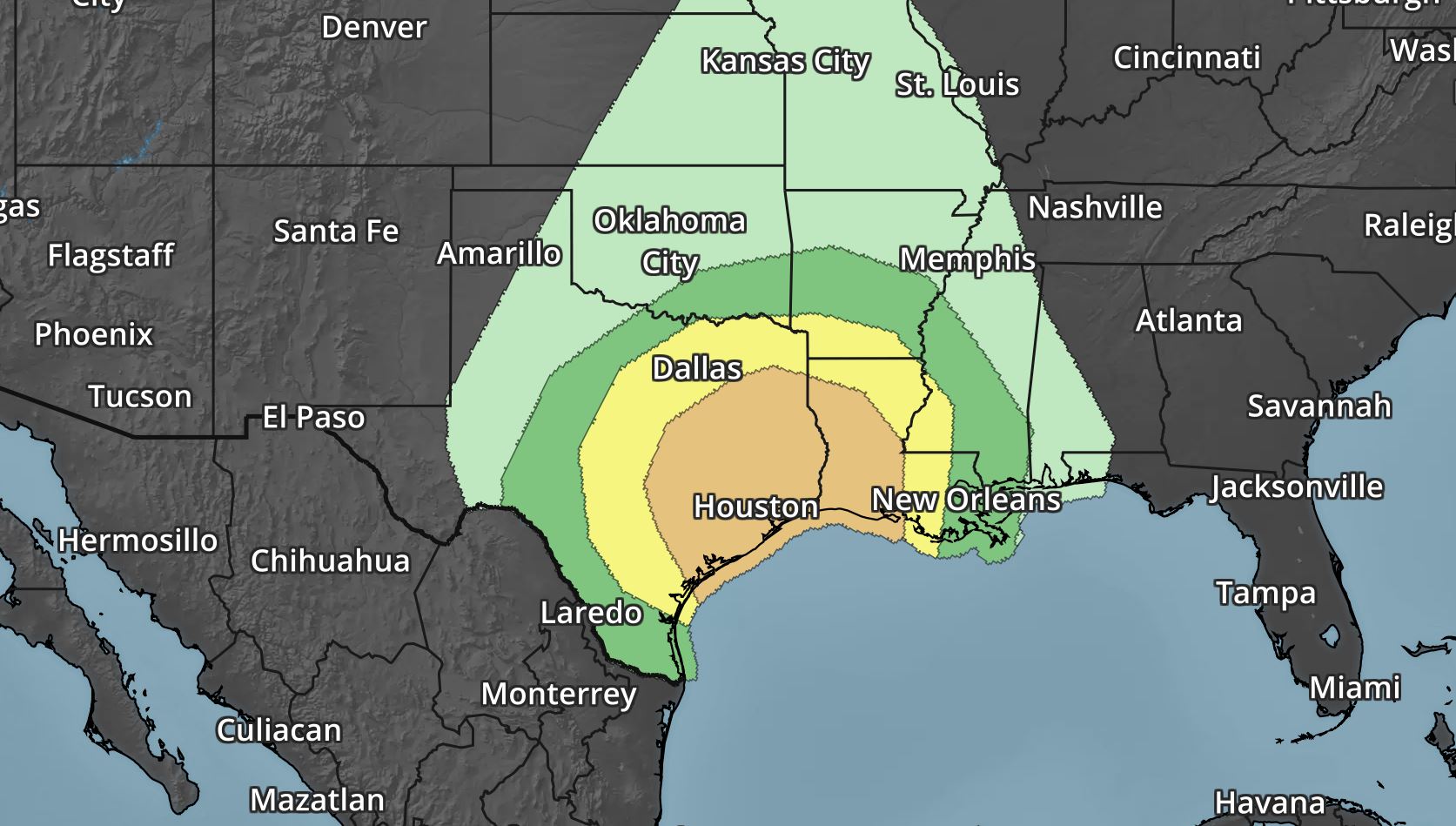
According to NOAA's SPC, the risk of severe weather continues right through the weekend and potentially into early next week. The images below are the severe threats on Saturday and Sunday respectively. In these particular areas, large hail, damaging winds, isolated tornadoes and locally heavy rainfall will all be possible.
Southern Rainfall Potential
With the threat of strong to severe thunderstorms continuing over the next few days, heavy rainfall will be possible as well. Take a look at the precipitation potential through Thursday, which suggests some 2" to near 4"+ rainfall tallies across the region, especially along and east of the Gulf Coast States
_________________________________________________________________________
2017 PRELIMINARY Tornado Count
According to NOAA's SPC, the PRELIMINARY tornado count for 2017 is at 423 (thru March 30). Interestingly, this is the highest number of tornado reports (thru March 30th) since 2012 when nearly 500 tornadoes were reported through that time frame. The 2005-2015 average number of tornado reports through March 30th is 219.
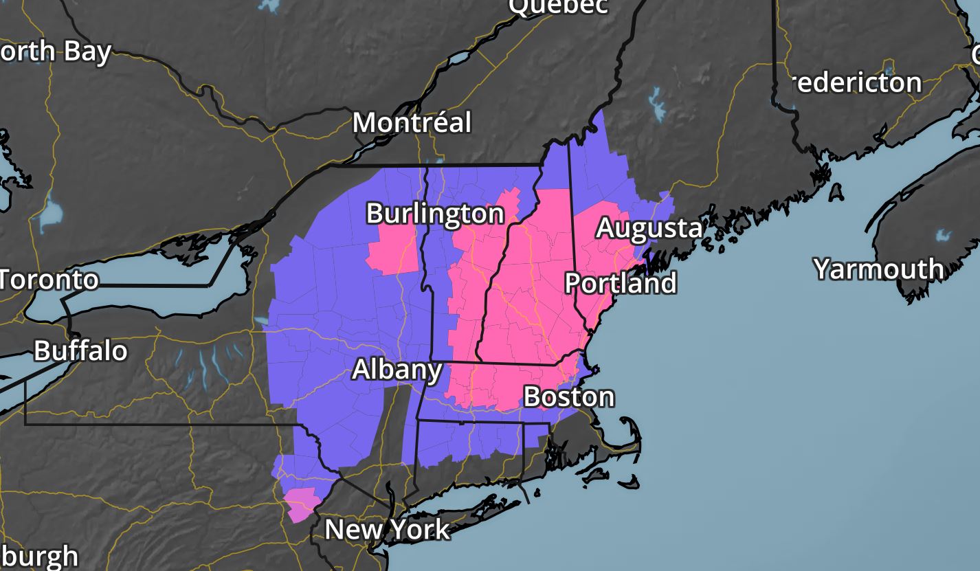
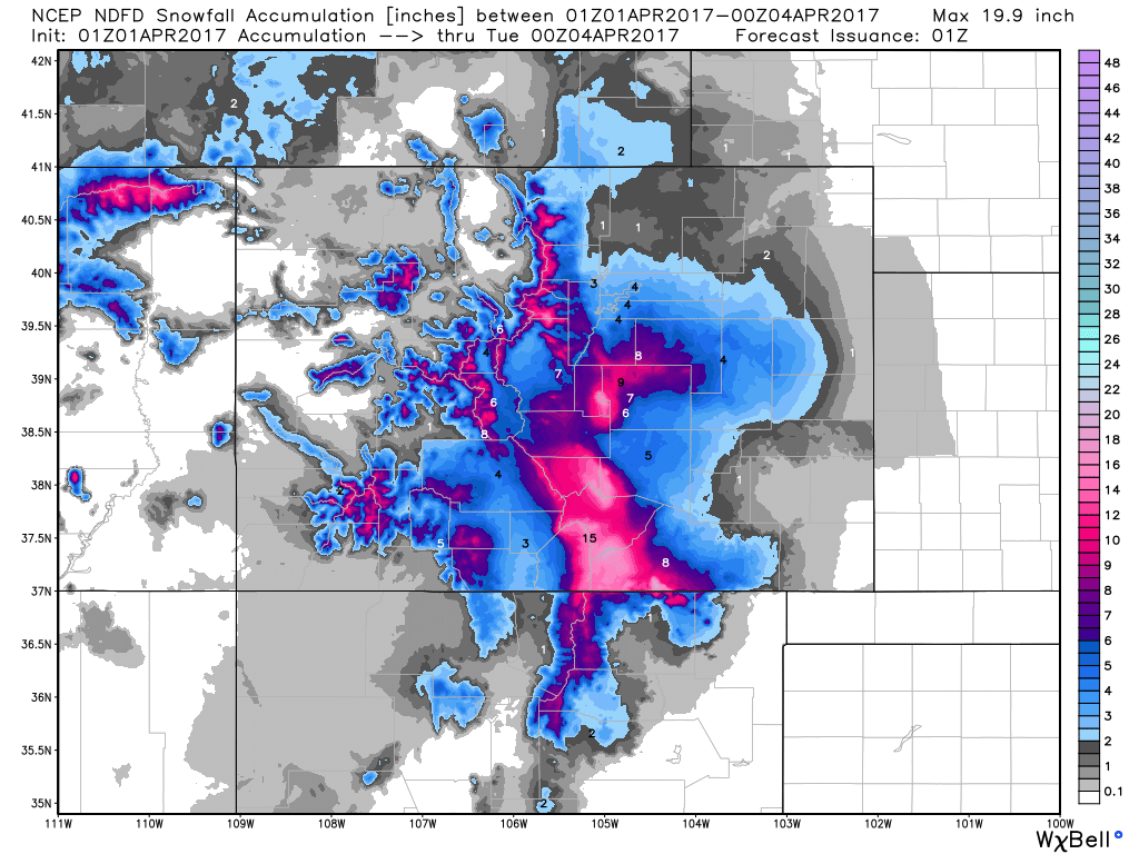
Late March Snow in the Northeast
The same storm system responsible for severe weather in the Central US over the past couple of days will be responsible for wintry weather across parts of the Northeast Friday & Saturday. Winter weather headlines have been posted for the potential of 8" to 12" of wet heavy snow that could lead to major travel concerns and even power outages.
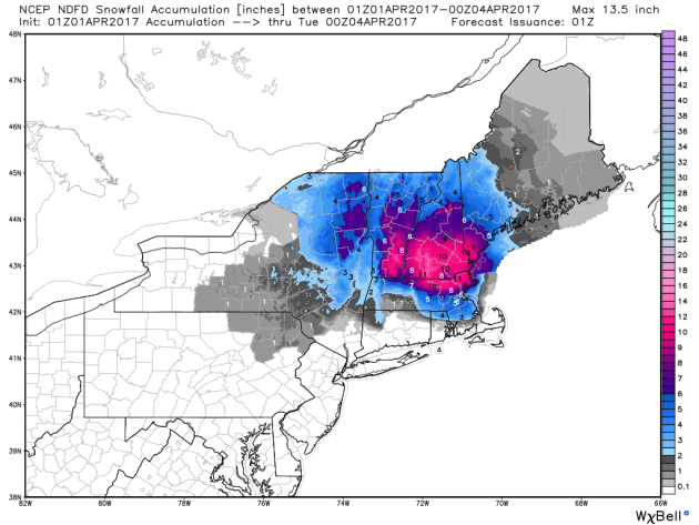
Snowfall Potential in the Northeast
Here's the snowfall potential through Monday, which suggests a fairly decent 4" to 8" swatch across the region with some 8" to 12" amounts across the higher elevations. The early April snow could be very wet and heavy in spots that could lead to some power outages.
Simulated Radar Through
Here's the simulated radar through early Sunday morning, which shows heavy precipitation continuing to move through the region early Saturday before tapering late Saturday night. While some across the far north and into the high elevations will see snow, others will see a steady rain, which could accumulated to 1" through Saturday.
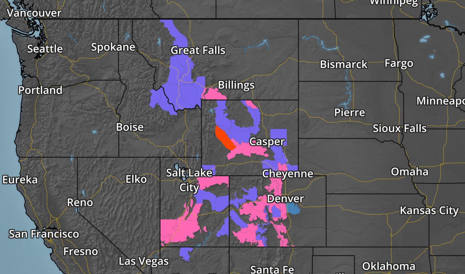
Winter Weather Concerns in the Western US
Another storm system will push through the Western US through the first half of the weekend with heavy snowfall potential across the higher elevations. The National Weather Service has issued a number of weather headlines through PM Saturday for snowfall potential of up to 12" or more!
Western Snowfall Potential
Here's the snowfall potential through PM Sunday, which shows heavy snowfall tallies across parts of the Intermountain West. Keep in mind that some of the heaviest amounts could top the 12" mark
________________________________________________________________________
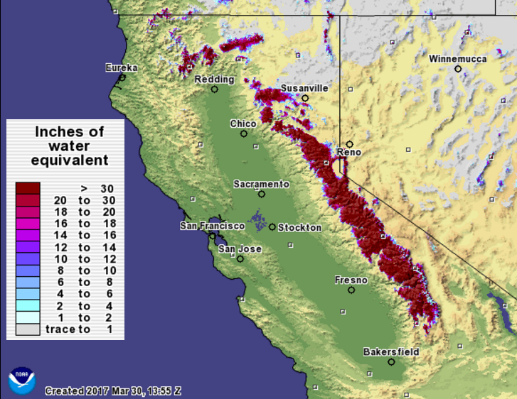
California Snowpack’s Water Content Remains Far above Average
According to the California Department of Water Resources, the California snowpack is running 164% of historical average for March 30th! The average statewide snow water equivalent (SWE) is 45.8" !! WOW, that a lot of water locked up in the snowy mountains! Here's an excerpt from a news release
SACRAMENTO – With every monthly measurement of the California snowpack this winter, the state’s rebound from the previous five years of drought becomes more evident. Today’s electronic readings from 95 sites in the Sierra Nevada show an average statewide snow water equivalent (SWE) of 45.8 inches, or 164 percent of the historical average for March 30 (27.9 inches).
Today’s manual snow survey by the Department of Water Resources (DWR) at Phillips Station in the Sierra Nevada found a SWE of 46.1 inches, 183 percent of the late March/early April long-term average at Phillips (25.2 inches). The three previous 2017 surveys at Phillips near the beginning of March, February and January found an SWE of 43.5 inches for March, 28 inches for February and 6 inches for January. SWE is the depth of water that theoretically would result if the entire snowpack melted instantaneously. That measurement is more important than depth in evaluating the status of the snowpack. On average, the snowpack supplies about 30 percent of California’s water needs as it melts in the spring and early summer. Electronic measurements indicate the water content of the northern Sierra snowpack is 40.8 inches, 147 percent of the multi-decade March 30 average. The central and southern Sierra readings are 50.5 inches (175 percent of average) and 43.9 inches (164 percent of average), respectively. Dr. Michael Anderson, State Climatologist, observed: “Although the record pace of the snowpack accumulation fell off significantly in March, California enters the snowmelt season with a large snowpack that will result in high water in many rivers through the spring." The Phillips snow course, near the intersection of Highway 50 and Sierra-at-Tahoe Road, is one of hundreds surveyed manually throughout the winter. Manual measurements augment the electronic readings from about 100 sensors in the state’s mountains that provide a current snapshot of the water content in the snowpack. Frank Gehrke, chief of the California Cooperative Snow Surveys Program, conducted DWR’s survey today at Phillips and said of his findings, "The storm track shifted away from California during March, but we still have a very substantial snowpack, particularly in the higher elevations in the central and southern Sierra. This is an extremely good year from the snowpack standpoint,” he said, adding that this year’s snowpack ranks in the upper quarter of historic snowpacks and is providing “great reservoir recovery.” Many Californians continue to experience the effects of drought, and some Central Valley communities still depend on water tanks and bottled water. Groundwater – the source of at least a third of the supplies Californians use – will take much more than even an historically wet water year to be replenished in many areas.
__________________________________________________________________________
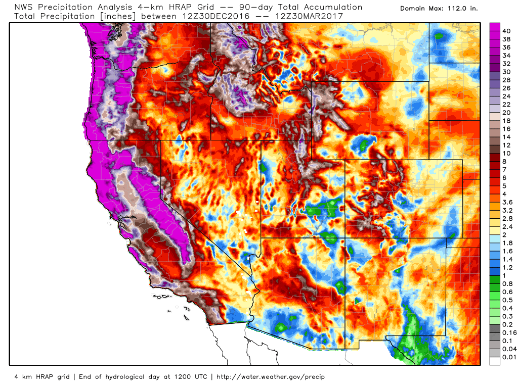
Precipitation Last 90 Days
Here's an interesting map! The radar estimated precipitation over the last 90 days suggests that nearly 40"+ of liquid precipitation has fallen across parts of the Western US since the end of December 2016! A steady stream of Pacific moisture earlier in the year really helped to boost precipitation values across the region.
____________________________________________________________________________
__________________________________________________________________________
Precipitation Last 90 Days
Here's an interesting map! The radar estimated precipitation over the last 90 days suggests that nearly 40"+ of liquid precipitation has fallen across parts of the Western US since the end of December 2016! A steady stream of Pacific moisture earlier in the year really helped to boost precipitation values across the region.
____________________________________________________________________________
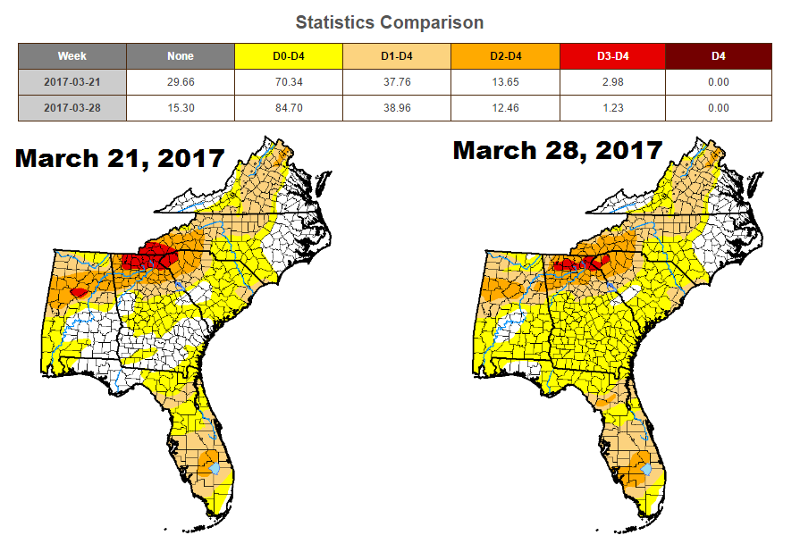
Drought Worsens in the Southeast
According to the US Drought Monitor, drought conditions in the Southeast continue to intensify. While EXTREME drought conditions have decreased from nearly 3% to a little more than 1%, more of the area under abnormally dry conditions going from 70% last week to nearly 85% this week.
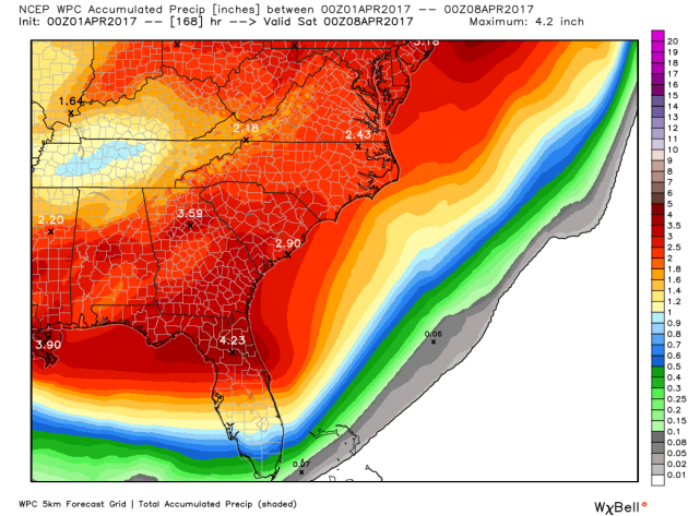
Rainfall Potential in the Southeast
The good news is that active weather conditions will help bring the potential of widespread heavy rainfall to the region through early next week. According precipitation forecast through Friday, some spots across the Southeast could see as much as 2" to 4" of rain.
_____________________________________________________________________________
By Paul Douglas
"Ceraunophilia" is a vaguely irrational love of lightning and thunder. I can't say I suffer from that affliction. I have a healthy respect for thunderstorms, having studied them for 45 year. It's true that a subset of thunderstorms can spawn large hail, damaging winds and tornadoes. But less than 1 in 10 T-storms will turn severe; fewer than 1 in 100 will ever spin up a tornado. If it wasn't for thunderstorms during the warm season Minnesota would have a climate similar to New Mexico. Precious little would grow here.
A higher sun angle will coax warmth & moisture northward from the Gulf of Mexico, increasing the potential for severe storms as we sail into April and May.
Weather apps, NOAA Weather Radio, local media & social media and sirens can keep you informed, but there's still no substitute for common sense. First growl of thunder? Head inside.
Saturday should be the nicer day of the weekend; a late-day instability shower Sunday. Big storms continue to track south of town this week. ECMWF guidance hints at 70F a week from Sunday, with a debilitating case of spring fever.
______________________________________________________________________________
Extended Forecast:
FRIDAY NIGHT: Mostly clear and chilly. Winds: NNE 5. Low: 34.
SATURDAY: Partly sunny and pleasant. Winds: S 7-12. High: 62.
SATURDAY NIGHT: Partly cloudy and quiet. Winds: SSW 5. Low: 41
SUNDAY: Sunny start. Pop-up shower late. Winds: S 7-12. High: 55.
MONDAY: Mix of clouds and sun. Dry for the MN Twins Opener. Winds: NE 5-10. Wake-up: 45. High: 60
TUESDAY: Patchy clouds, still pretty quiet. Winds: NE 8-13. Wake-up: 44. High: 59
WEDNESDAY: Cloudy with rain across southern MN. Winds: NE 8-13. Wake-up: 43. High: 55.
THURSDAY: Mostly cloudy. Cooler breeze kicks in. Winds: NNW 10-20. Wake-up: 39. High: 51.
FRIDAY: Sunny skies, winds slowly east. Winds: NW 8-13. Wake-up: 35. High: 57
_______________________________________________________________________________
_______________________________________________________________________________
This Day in Weather History
April 1st
April 1st
1882: A record high of 75 degrees is set at Minneapolis.
_______________________________________________________________________________
_______________________________________________________________________________
Average High/Low for Minneapolis
April 1st
April 1st
Average High: 50F (Record: 84F set in 2015)
Average: Low: 31F (Record: 9F set in 1975)
Average: Low: 31F (Record: 9F set in 1975)
*Record Snowfall: 4.6" set in 2002
_______________________________________________________________________________
_______________________________________________________________________________
Sunrise Sunset Times For Minneapolis
April 1st
April 1st
Sunrise: 6:53am
Sunset: 7:41pm
Sunset: 7:41pm
*Daylight Gained Since Yesterday: ~3 minutes & 7 seconds
*Daylight Gained Since Winter Solstice (December 21st): ~4 hours & 4 minute
________________________________________________________________________________
*Daylight Gained Since Winter Solstice (December 21st): ~4 hours & 4 minute
________________________________________________________________________________
Moon Phase for March 31st at Midnight
2.5 Days Before First Quarter
2.5 Days Before First Quarter
________________________________________________________________________________
Weather Outlook For Saturday
High temperatures on Saturday will be quite warm across region. With highs in the 50s and low 60s, we'll be above average for the first day of April!
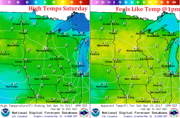
Weather Outlook For Saturday
Here are the winds for Saturday, which look pretty negligable for much of the day. No worries here, move along.
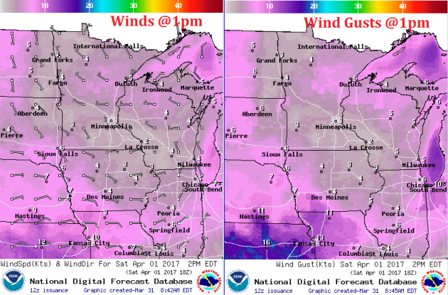
Skies will remain sunny early in the day, but clouds will be on the increase late as our next rain makes movves in on Sunday.