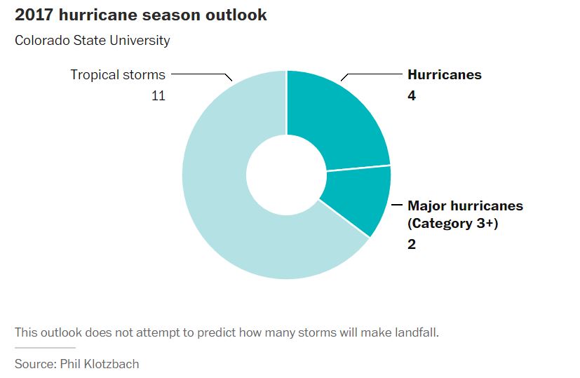
2017 hurricane outlook: Colorado State predicts a slightly-below average season
Here we are at the beginning of April and we're already starting to think about the 2017 hurricane season. With the official start of the Atlantic hurricane season not starting until June 1st, Colorado State is already predicting a slightly below average season. By the way, the 2016 Atlantic Hurricane season was the first above average season since 2012! It produced 15 named storms, 7 of which were hurricane and 4 of those were major hurricanes (category 3 or higher). Here's an excerpt from the WashingtonPost about the the recent hurricane forecast: "It’s that time. The time to think about (and prepare for) hurricane season, which begins on June 1. Each year, the tropical weather research group at Colorado State University issues an outlook for the season — how many tropical storms and hurricanes the Atlantic may see in the coming months. This year, the group predicts hurricane season will be just shy of average. They think there will be 11 named storms. Of those, they believe four will become hurricanes, and two will become major hurricanes (Category 3 or stronger). What this prediction doesn’t try to determine is how many of these storms will make landfall.
Named Storms (12)* 11
Named Storm Days (60.1) 50
Hurricanes (6.5) 4
Hurricane Days (21.3) 16
Major Hurricanes (2.0) 2
Major Hurricane Days (3.9) 4
Accumulated Cyclone Energy (92) 75
Net Tropical Cyclone Activity (103%) 85
* Numbers in ( ) represent medians based on 1981-2010 data.
Named Storm Days (60.1) 50
Hurricanes (6.5) 4
Hurricane Days (21.3) 16
Major Hurricanes (2.0) 2
Major Hurricane Days (3.9) 4
Accumulated Cyclone Energy (92) 75
Net Tropical Cyclone Activity (103%) 85
* Numbers in ( ) represent medians based on 1981-2010 data.
 _______________________________________________________________________
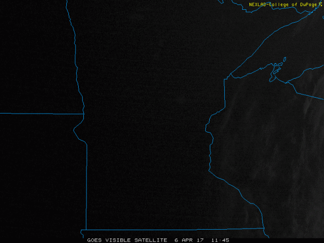
Visible Satellite on Thursday
It sure was nice to see the sun again on Thursday, wasn't it? Despite the winds being a little breezy, sunny skies and temperatures in the 50s made for a very pleasant early April day. If you liked Thursday, you will certainly like Friday and Saturday as sunshine continues along with even warmer temperatures! We even had a chance at our first 70F high temp of the year on Saturday. Note that Mille Lacs, Leech and Upper/Lower Red Lakes look white. That's because they are still ice covered, but ice is melting quickly!
 ___________________________________________________________________________
___________________________________________________________________________
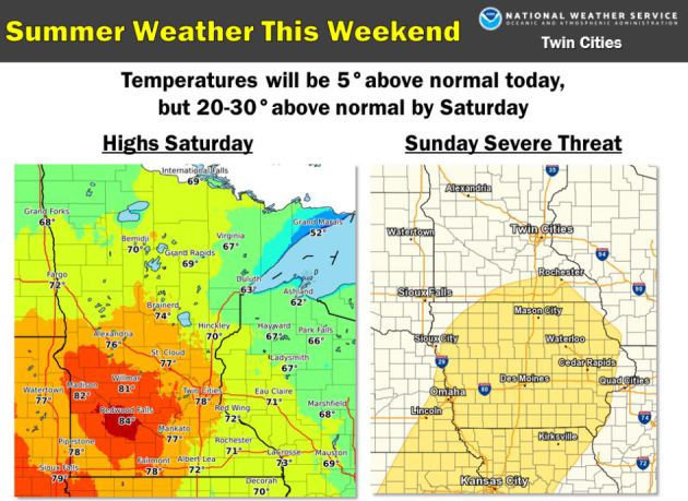
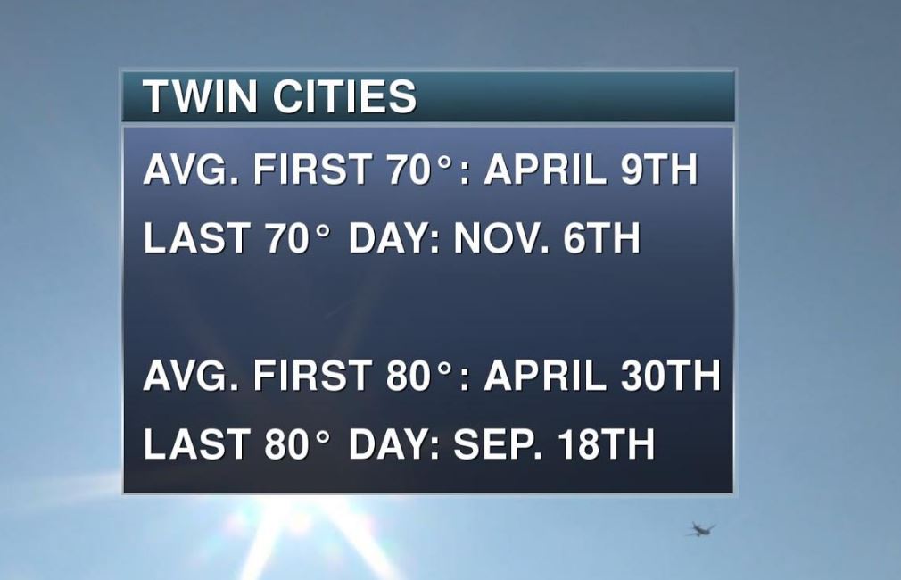
Take a look at the weather this weekend! WOW! With highs in the 70s and 80s across parts of central and southern MN, this will be one of the warmest days we've seen since last fall. By the way, the last time the Twin Cities hit 70F+ was on November 6th, 2016 (70F) and the last time the we had an 80F+ was on September 18th, 2016 (84F). The warm weather may be follow by strong to severe thunderstorms late Sunday as another storm system rolls through the Midwest. Stay tuned!
___________________________________________________________________________
______________________________________________________________________
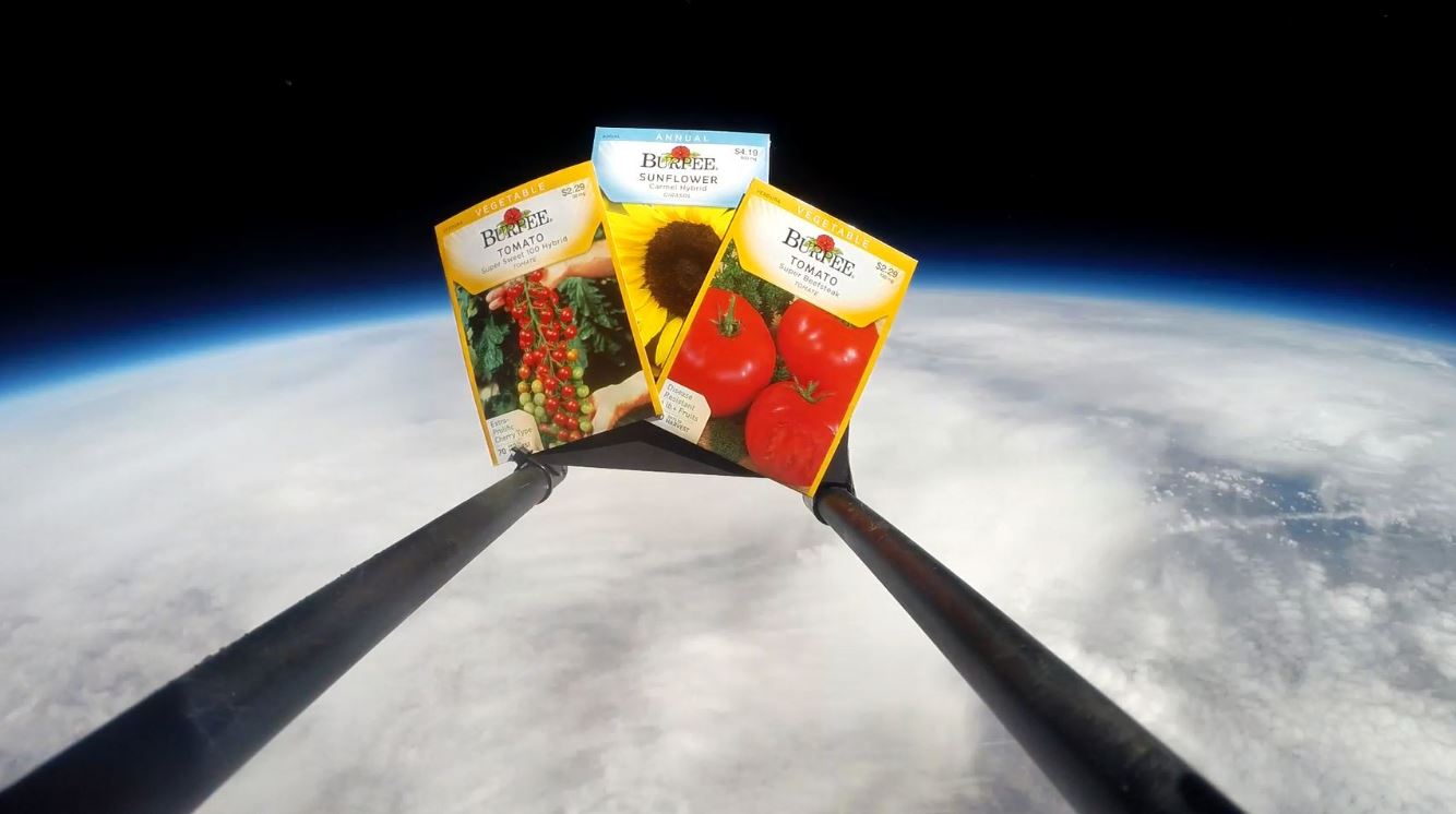
Space Seeds?
If you're a gardener or a space guru this might be of some interest to you. Here's an excerpt from Earth to Sky Calculus regarding space seeds, which you can purchase if you're interested: "Northern Spring has arrived, and that means it's time to plant your garden. Your SPACE garden, that is. On March 26th, the students of Earth to Sky Calculus flew a payload-full of tomato and sunflower seeds to the edge of space. Carried 115,500 feet high by a giant helium balloon, the packets experienced temperatures as low as -63 C and cosmic ray dose rates 100 times Earth-normal. What will these far-out seeds yield? Find out for yourself! For only $39.95 we will send you a packet of space seeds along with control samples that remained on the ground during the flight. Plant them side by side for a backyard science experiment. Each shipment comes with a card telling the story of the flight and certifying that the seeds have been to the stratosphere and back again. Please specify your seed preference (Beefsteak tomato, cherry tomato, or sunflower) in the comments box at checkout."
See more from Earth to Sky Calculus HERE:
______________________________________________________________________________
Active Weather Continues
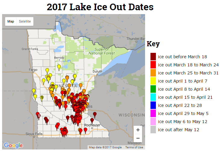
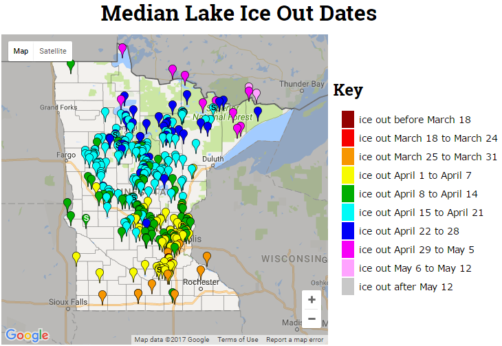
2017 Ice Out Dates
Here's the latest MN DNR ice out dates, which shows that more lakes across Central MN have officially gone out for the season. Note that ice outs are occurring nearly 1 to 2 weeks ahead of schedule this year!
___________________________________________________________________________
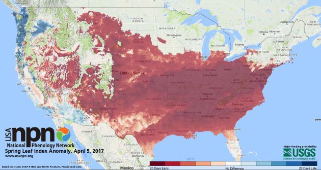
Spring 2017 Continues to Arrive Early Across the Nation
According to the National Phenology Network spring has sprung across much of the nation and arriving nearly 20 days earlier than a long-term average (1981-2010) in much of the South, Great Plains, Great Basin, mid-Atlantic, Midwest and parts of the Northeast.
See more from the USA NPN here:
_________________________________________________________________
Feels Like Summer This Weekend!
See more from the USA NPN here:
_________________________________________________________________
___________________________________________________________________________
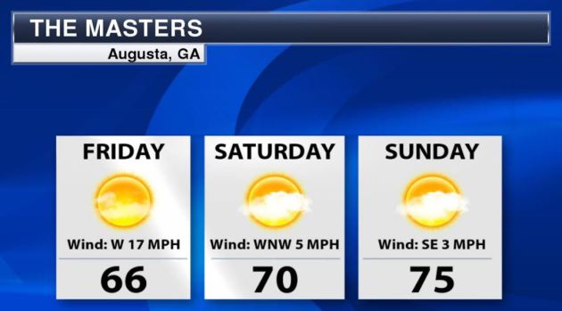
Masters Weekend
Another sure sign of spring is when the Masters golf tournament rolls around. Friday will be day 2 of play at the Augusta National Golf Club in Augusta, GA. The course was closed on Wednesday due to significant severe weather concerns. Strong winds in the wake of the storm system made for an interesting and somewhat difficult opening round of play Thursday. Although it appears to still be a bit breezy on Friday, weather conditions will be pretty pleasant this the weekend! I am looking forward to watching some great golf this weekend.
______________________________________________________________________
See more from Earth to Sky Calculus HERE:
______________________________________________________________________________
Active Weather Continues
The strong storm system that brought several days of strong to severe weather across the eastern two-thirds of the nation earlier this week will slowly exit the Northeast on Friday and Saturday with lingering rain/snow showers and gusty winds. Another Pacific storm system will edge into the Western US with strong winds, heavy mountain snow, heavy rain and even strong to severe thunderstorms. The new storm system will slide into the Central US over the weekend with some soaking rains and a chance of strong to severe storms.
.gif)
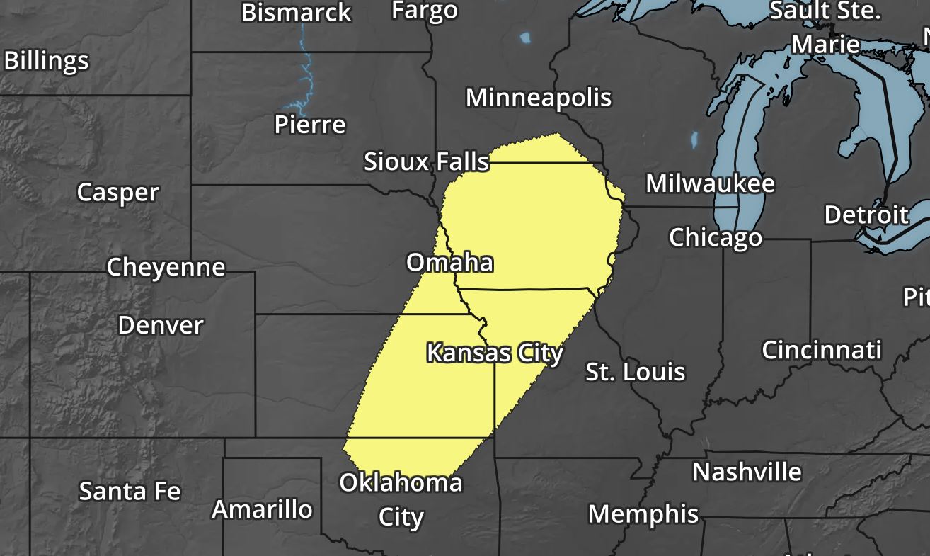
Several Weather Threats Ahead
As our next storm system rolls in off the Pacific, strong to severe thunderstorms maybe possible over the next few days. Here are the severe thunderstorm risks for Friday, Saturday and Sunday below. Note that by Sunday, the severe threat will once again be in the Central US. Stay tuned...
_________________________________________________________________________
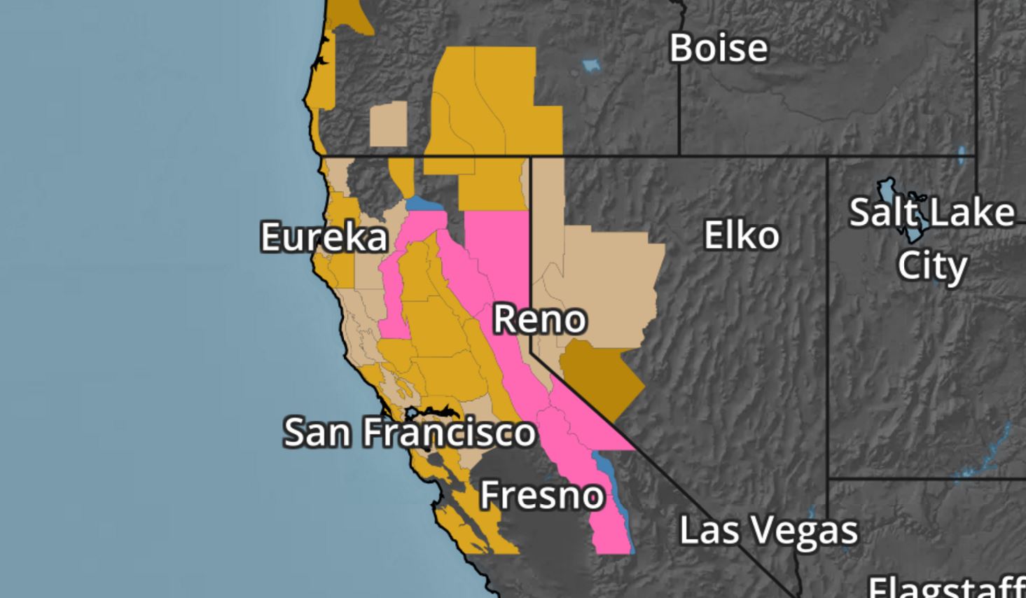
Strong Pacific Storm Hits The West Coast
A very strong Pacific storm will push through the Western US in a couple of different waves, but the end result will bring strong winds, heavy coastal rain and heavy mountain snow through Saturday. Here's the simulated radar from early AM Friday to early AM Sunday.
.gif)
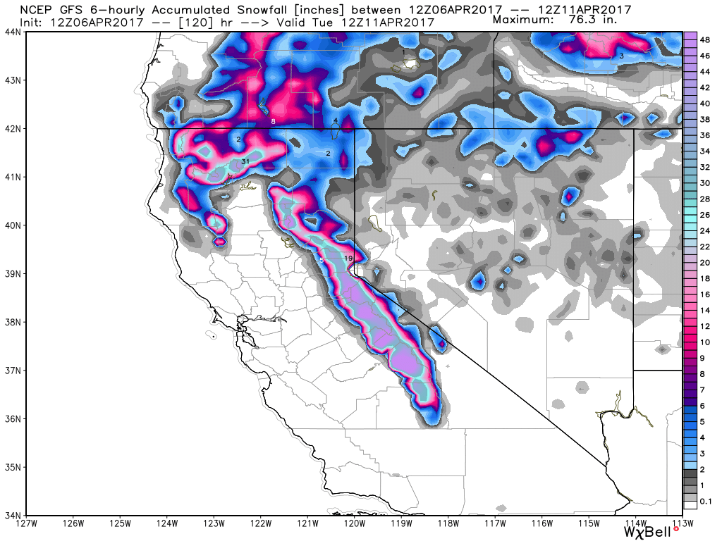
Hurricane Force Winds & Fee of Snow in the Sierras
Our next Pacific storm system will pack a fairly decent punch as it moves across the northern half of California. High Wind Warnings and Winter Storm Warnings have been posted by the National Weather Service until Saturday. Winds could gust to hurricane force (74mph+), while snowfall tallies above 7,000ft. could approach 2ft. to 3ft. as the storm fades this weekend. Unreal!
Sierra Snowfall
WOW! Another massive snow dump continues in the mountains of California with some spots seeing as much as 2ft. to 3ft. by Saturday.
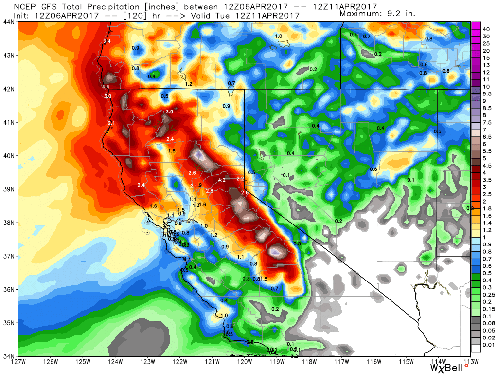
California Precipitation Forecast
The precipitation forecast through early next week look pretty impressive with widespread 2" to 4"+ liquid tallies across the region. This late season heavy Pacific moisture adds to what have been a very impressive stretch of heavy moisture for the West Coast over the last several months.
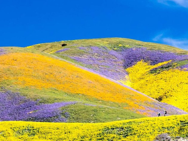
California's Rare "Super Bloom" Flowers Are Migrating North
In March, California made headlines with a so called "Super Bloom" across parts of Southern California. Well now that "Super Bloom" is migrating north and has parts of the Central Valley cascading in color! Unfortunately, those flowers are being trampled by the high volume of tourists checking out the rare view: Here's an excerpt from Architectural Digest: A winter of heavy rainfall in California meant this year's flowers are even more vibrant—and they have spread to new locations. Perhaps nothing announces spring better than a valley of blooming wild flowers. And that is just what residents and visitors of California's Central Valley have experienced this week. After the Bureau of Land Management posted an Instagram picture of the lush landscape yesterday, the Internet took notice as images began spreading throughout the web. "The show is simply indescribable...like something out of a storybook," the Bureau's caption read. "The Valley floor has endless expanses of yellows and purples from coreopsis, tidy tips, and phacelia, with smaller patches of dozens of other species." Generally, California's "Super Bloom" occurs in locations such as the Anza-Borrego Desert outside of San Diego and Walker Canyon near southern Los Angeles. This year, however, the blooming moved some 50 miles north of L.A. in and around Carrizo Plain. This has caused residents and tourists alike to flock the generally quiet valley. As a result, officials have been forced to place signs urging visitors to stay on marked trails as there have been reports of flowers being trampled.
See more from Architectural Digest HERE:
(California's "Super Bloom" has traveled north of L.A. this year to the Carrizo Plain.Photo: Courtesy of the Bureau of Land Management)
 ____________________________________________________________________Active Weather Last 2 Weeks
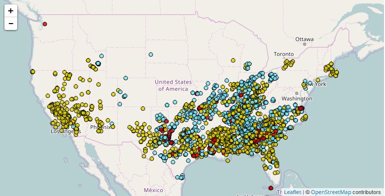
It certainly has been an active pattern over the last couple of weeks. In fact, there have been severe weather reports everyday since March March 23rd! According to NOAA's SPC, there have been nearly 1,500 severe storm reports since then, nearly 600 of those occurring during the first 6 days of April.
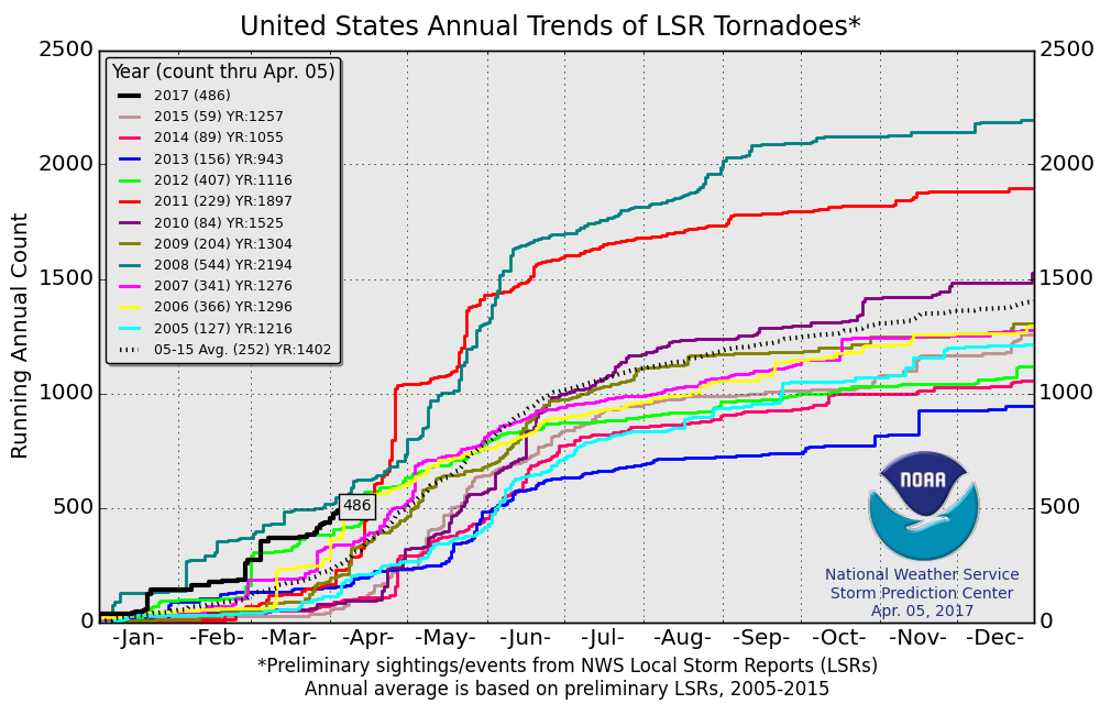
2017 PRELIMINARY Tornado Count
According to NOAA's SPC, the PRELIMINARY tornado count for 2017 is at 486 (thru April 5). Interestingly, this is the highest number of tornado reports (thru April 5) since 2008 when 544 tornadoes were reported through that time frame. The 2005-2015 average number of tornado reports through April 5 is 252.
 ________________________________________________________________
As our next storm system rolls in off the Pacific, strong to severe thunderstorms maybe possible over the next few days. Here are the severe thunderstorm risks for Friday, Saturday and Sunday below. Note that by Sunday, the severe threat will once again be in the Central US. Stay tuned...
_________________________________________________________________________
Strong Pacific Storm Hits The West Coast
A very strong Pacific storm will push through the Western US in a couple of different waves, but the end result will bring strong winds, heavy coastal rain and heavy mountain snow through Saturday. Here's the simulated radar from early AM Friday to early AM Sunday.
Hurricane Force Winds & Fee of Snow in the Sierras
Our next Pacific storm system will pack a fairly decent punch as it moves across the northern half of California. High Wind Warnings and Winter Storm Warnings have been posted by the National Weather Service until Saturday. Winds could gust to hurricane force (74mph+), while snowfall tallies above 7,000ft. could approach 2ft. to 3ft. as the storm fades this weekend. Unreal!
Sierra Snowfall
WOW! Another massive snow dump continues in the mountains of California with some spots seeing as much as 2ft. to 3ft. by Saturday.
California Precipitation Forecast
The precipitation forecast through early next week look pretty impressive with widespread 2" to 4"+ liquid tallies across the region. This late season heavy Pacific moisture adds to what have been a very impressive stretch of heavy moisture for the West Coast over the last several months.
California's Rare "Super Bloom" Flowers Are Migrating North
In March, California made headlines with a so called "Super Bloom" across parts of Southern California. Well now that "Super Bloom" is migrating north and has parts of the Central Valley cascading in color! Unfortunately, those flowers are being trampled by the high volume of tourists checking out the rare view: Here's an excerpt from Architectural Digest: A winter of heavy rainfall in California meant this year's flowers are even more vibrant—and they have spread to new locations. Perhaps nothing announces spring better than a valley of blooming wild flowers. And that is just what residents and visitors of California's Central Valley have experienced this week. After the Bureau of Land Management posted an Instagram picture of the lush landscape yesterday, the Internet took notice as images began spreading throughout the web. "The show is simply indescribable...like something out of a storybook," the Bureau's caption read. "The Valley floor has endless expanses of yellows and purples from coreopsis, tidy tips, and phacelia, with smaller patches of dozens of other species." Generally, California's "Super Bloom" occurs in locations such as the Anza-Borrego Desert outside of San Diego and Walker Canyon near southern Los Angeles. This year, however, the blooming moved some 50 miles north of L.A. in and around Carrizo Plain. This has caused residents and tourists alike to flock the generally quiet valley. As a result, officials have been forced to place signs urging visitors to stay on marked trails as there have been reports of flowers being trampled.
See more from Architectural Digest HERE:
(California's "Super Bloom" has traveled north of L.A. this year to the Carrizo Plain.Photo: Courtesy of the Bureau of Land Management)
It certainly has been an active pattern over the last couple of weeks. In fact, there have been severe weather reports everyday since March March 23rd! According to NOAA's SPC, there have been nearly 1,500 severe storm reports since then, nearly 600 of those occurring during the first 6 days of April.
2017 PRELIMINARY Tornado Count
According to NOAA's SPC, the PRELIMINARY tornado count for 2017 is at 486 (thru April 5). Interestingly, this is the highest number of tornado reports (thru April 5) since 2008 when 544 tornadoes were reported through that time frame. The 2005-2015 average number of tornado reports through April 5 is 252.
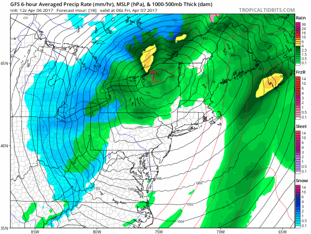
Strong Storm Fades by Saturday
The same storm system that was responsible for several days of severe weather across the Eastern half of the country will continue to be a nuisance across the Northeast on Friday and early Saturday. Heavy, steady rains will begin to fade, but cool, blustery weather with lingering snow showers will lingering through late Friday/early Saturday.
Flood Watches Continue
Flood watches continue through PM Friday across parts of the Northeast as steady soaking rains on Thursday blanketed the region. In combination with above freezing temperatures and snow melt, rivers and streams will be on the rise, which may lead to flooding.
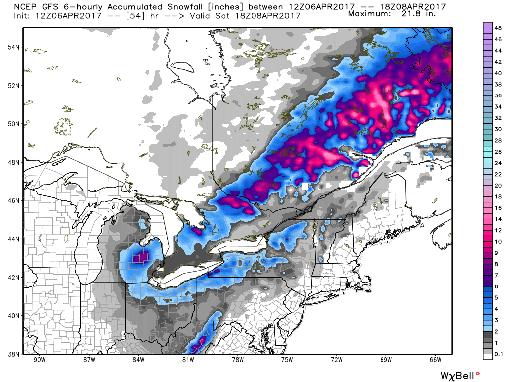
Snowfall Potential
Here's the snowfall potential through Saturday, which shows slushy snow accumulations from PM Thursday to AM Saturday from parts of the Great Lakes and Ohio Valley to parts of Eastern Canada. Some very minor accumulations maybe possible throughout parts of the Eastern Great Lakes and Northeast through AM Saturday as well.
_____________________________________________________________________________
Phenology: Using Nature to Track Weather Trends
By Paul Douglas
I love Minnesota's increasingly super-sized summers. But there's something about the first warm spell of April, when you can finally un-clench those tense winter muscles; summer without the baggage of humidity, bugs and raging thunderstorms.
Phenology is the study of how plant and animal life cycles are influenced by environmental changes. NASA can track spring green-up from space, but nature provides her own cues, as we track the date of first dandelions, frogs, lilacs and crabapples. According to the Minnesota DNR the first red-winged blackbirds of the season were heard in Maplewood on March 5, 9 days earlier than average - the second earliest on record.
Odds are you'll be chirping a happy tune Friday and Saturday as temperatures mellow. The first 70F of 2017 is possible Saturday, right on schedule. A few T-storms bubble up on Sunday, but dew points and instability may not be sufficient to support anything severe.
Enjoy the drama-free weather. Tornadoes down south, slush in the Great Lakes, soaking rains on both coasts. And here we sit, meteorologically content. For now.
______________________________________________________________________________
Extended Forecast:
THURSDAY NIGHT: mostly clear, frosty suburbs. Winds: N 5. Low: 32
FRIDAY: Sunny, sneak out of office early. Winds: S 10-15. High: 63
FRIDAY NIGHT: Partly cloudy, not as chilly. Winds: S 10. Low: 46
SATURDAY: Sunny. Feels like May. Winds: S 10-15. High: 73
SUNDAY: More clouds, few T-storms. Winds: SE 8-13. Wake-up: 54. High: 69
MONDAY: Showery rains linger, cooling off. Winds: NE 10-20. Wake-up: 46. High: 52
TUESDAY: Sunny peeks, drying out. Winds: NW 8-13. Wake-up: 36. High: 54
WEDNESDAY: Mostly sunny and pleasant. Winds: SE 5-10. Wake-up: 34. High: 59.
THURSDAY: Clouds increase, a mild breeze. Winds: SE 10-20. Wake-up: 42. High: 60.
_______________________________________________________________________________
_______________________________________________________________________________
This Day in Weather History
April 7th
April 7th
1857: A cold snap hits the United States, with snow reported in every state.
_______________________________________________________________________________
_______________________________________________________________________________
Average High/Low for Minneapolis
April 7th
April 7th
Average High: 53F (Record: 83F set in 1991)
Average: Low: 33F (Record: 6F set in 1936)
Average: Low: 33F (Record: 6F set in 1936)
*Record Snowfall: 8.9" set in 1923
_______________________________________________________________________________
_______________________________________________________________________________
Sunrise Sunset Times For Minneapolis
April 7th
April 7th
Sunrise: 6:42am
Sunset: 7:49pm
Sunset: 7:49pm
*Daylight Gained Since Yesterday: ~3 minutes & 5 seconds
*Daylight Gained Since Winter Solstice (December 21st): ~4 hours & 22 minute
________________________________________________________________________________
*Daylight Gained Since Winter Solstice (December 21st): ~4 hours & 22 minute
________________________________________________________________________________
Moon Phase for April 6th at Midnight
3.5 Days Since First Quarter
3.5 Days Since First Quarter
________________________________________________________________________________
Weather Outlook For Friday
Friday will be another spectacular day with bright sunshine and mild temperatures. We are looking at highs that will bounce into the 60s across much of the state by the afternoon.
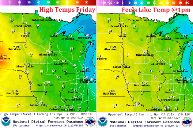
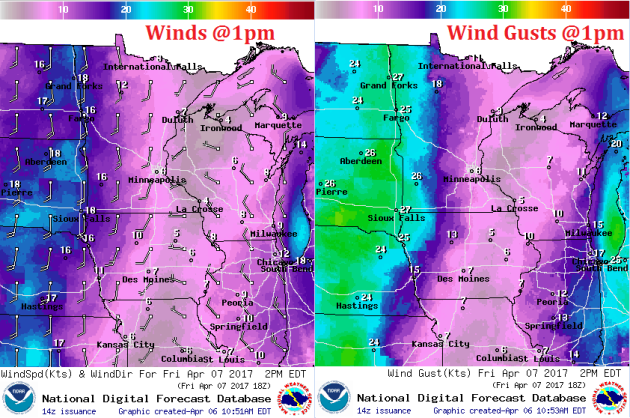
Weather Outlook For Friday
Winds will start to pick up a little out of the south Friday afternoon with gusts approaching 20mph+ across the western part of the state. This southerly wind will ultimately help to transport some very mild air into the region by Saturday with highs in the 70s & possibly 80s then!
Other than a few clouds, Friday will feature mostly sunny skies. Enjoy!