61 F. average high on April 21.
66 F. high on April 21, 2016.
April 22, 1874: Unseasonably cold air moves into Minnesota. The low is 23 degrees at the Twin Cities.
5.4" snow fell on the Twin Cities on April 22, 1963.
A 3-Star, Blue-Ribbon, Award-Winning Earth Day
"God saw all that he had made and it was very good" says Genesis 1:31. The Bible tells us we were created in God's image. He gave us big, beautiful brains, the ability to reason, solve problems and improve our lives. And the good sense not to foul our nest.
"God saw all that he had made and it was very good" says Genesis 1:31. The Bible tells us we were created in God's image. He gave us big, beautiful brains, the ability to reason, solve problems and improve our lives. And the good sense not to foul our nest.
"I
do not feel obliged to believe that the same God who endowed us with
sense, reason and intellect has intended us to forgo their use" Galileo
observed, in 1615.
As
scientists around the nation march today the question arises: do we all
have a right, constitutional or otherwise, to clean air and water - and
a stable climate?
I
predict distracting levels of lukewarm sunshine today as a few
optimistic bank thermometers flash 70F by late afternoon. This is the
day you were day-dreaming about a few months ago during our alleged
winter.
A
brush with cooler air scuffs up our sky with more clouds tomorrow; a
shower north of the metro with more 60s and few complaints. I see a
cool, wet bias the next couple of weeks, the best chance of showers next
Monday and Friday.
It could be worse: April 2013 brought 18 inches of snow to the Twin Cities!
April Continues Trend of Warm and Wet. Here are a couple brief excerpts from Dr. Mark Seeley's latest edition of Minnesota WeatherTalk: "So
far this month most Minnesota climate observers are reporting warmer
and wetter than normal conditions. Temperatures are averaging 5 to 7
degrees F warmer than normal. Through April 19th eight daily record
maximum temperatures have been tied or set within the climate
observation networks, while thirty-nine daily record warm minimum
temperature records have been tied or set...Clearly this month is
following a trend from the last two years (24 months) during which 22
months have been warmer than normal, and 16 months have been wetter than
normal..."
Fleeting Tropical Storm Arlene.
For only the second time on record we had a tropical storm (Arlene) in
the Atlantic for a time Friday, but wind shear rapidly weakened the
storm. Loop: AerisWeather AMP.
Severe Risk Mid South.
The best chance of large hail, damaging winds and even a few isolated
tornadoes later today will be across Mississippi, Alabama and Tennessee,
where watches and warnings are likely. Map credit: NOAA SPC.
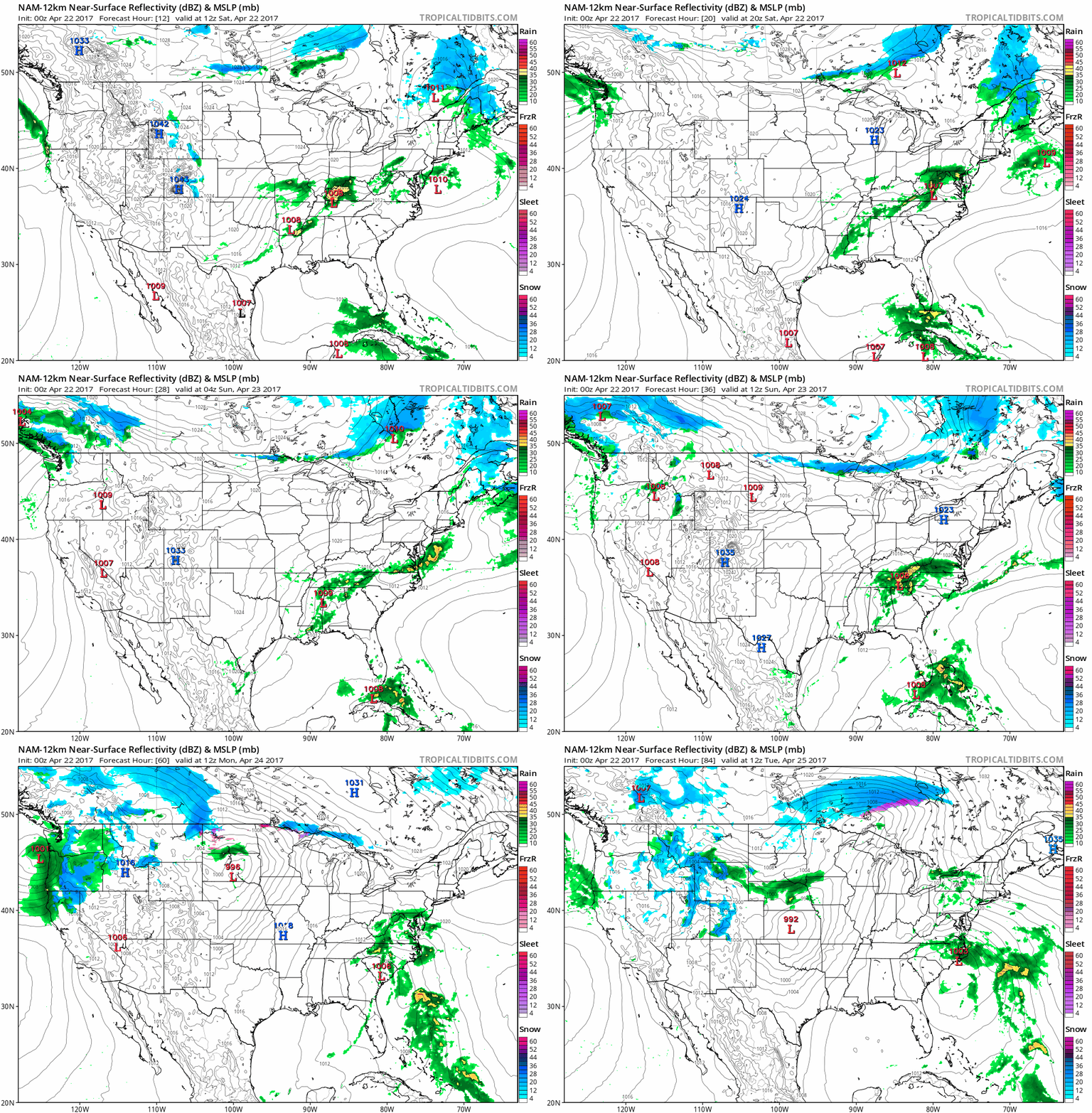
Lukewarm Into Monday, Then Cooling Off.
No slushy fronts are brewing, but I wouldn't retire the light jackets
and sweatshirts just yet; highs hold in the low to mid 50s from Tuesday
into next weekend before slowly moderating again. MSP temperature
outlook from ECMWF: WeatherBell.
March Data Confirms Earth Is On a Hot Streak. More perspective from Climate Central: "To say the world is having a streak like no other is an understatement. Global warming has made cold scarce
on a planetary scale. This March clocked in as the second warmest March
on record when compared to the 20th century average, according to newly
released data from the National Oceanic and Atmospheric
Administration. NASA data published last week came to the same conclusion, comparing
temperatures to a 1951-1980 baseline. The NOAA data shows the planet
was 1.9°F (1.05°C) above the 20th century average for March, the first
time any month has breached the 1°C threshold in the absence of El Niño.
This March is the latest freakishly hot month following three years in a
row of record heat..."
El Nino: Watching, Waiting For Signs It Could Return. AL.com has an update: "La Nina is history -- but El Nino might not be gone for long. That's according to the latest monthly discussion on
the matter from climate researchers. ENSO-neutral conditions prevailed
in March, and could continue though at least the rest of the spring,
according to the report from a group that includes NOAA's Climate
Prediction Center, the National Centers for Environmental Prediction,
the National Weather Service and the International Research Institute
for Climate and Society. However, researchers believe there are
increasing odds of El Nino returning by the late summer or fall..."
Heat Waves Kill. From 2000 to 2010 at least 35 deaths were directly attributable to extreme heat in Minnesota. The Minnesota Department of Public Safety explains the different criteria involved in setting expectations for heat-related problems: "The National Weather Service issues the following heat-related products as conditions warrant:
Excessive Heat Outlooks:: are issued when the potential exists for an excessive heat event in the next 3-7 days. An Outlook provides information to those who need considerable lead time to prepare for the event, such as public utility staff, emergency managers and public health officials.
Excessive Heat Outlooks:: are issued when the potential exists for an excessive heat event in the next 3-7 days. An Outlook provides information to those who need considerable lead time to prepare for the event, such as public utility staff, emergency managers and public health officials.
Excessive Heat Watches:
are issued when conditions are favorable for an excessive heat event in
the next 24 to 72 hours. A Watch is used when the risk of a heat wave
has increased but its occurrence and timing is still uncertain. A Watch
provides enough lead time so that those who need to prepare can do so,
such as cities officials who have excessive heat event mitigation plans.
Excessive Heat Warning/Advisories
are issued when an excessive heat event is expected in the next 36
hours. These products are issued when an excessive heat event is
occurring, is imminent, or has a very high probability of occurring. The
warning is used for conditions posing a threat to life. An advisory is
for less serious conditions that cause significant discomfort or
inconvenience and, if caution is not taken, could lead to a threat to
life.
Americans Are Getting Less Advance Notice for Tornadoes, as Researchers Struggle to Understand Why.
Are we drowning in too much data? With Doppler radar technology and new
research coming online you would think that all the trends would be
positive, but Jason Samenow explains the challenges faced by warning
meteorologists at Capital Weather Gang: "...About
a decade ago, the tornado false alarm rate was about 80 percent. This
meant for every five tornado warnings issued, only one tornado would
occur. This false alarm percentage has since dropped to 70 percent. In
sum, it appears Weather Service forecasters are not preparing people for
tornadoes as well as they did five years ago, but also are
not needlessly warning them as much. Brooks says these two developments
are related and tied to what’s going on inside the forecaster’s
head when forced with the stressful decision of whether to issue a
warning. In recent years, Brooks said, the Weather Service has placed
“increased emphasis” on reducing false alarm rates, which may be
motivating some forecasters to issue fewer warnings. Brooks referred
to “unofficial efforts,” not policy, within the agency to curb false
alarm frequency..." (Graphic credit: National Weather Service).
Extreme 4K Footage Puts You Right Next to a Massive Tornado in Colorado. The video is incredible; here's a link and excerpt at PetaPixel: "Incredible… and terrifying. Last year, extreme storm chaser Reed Timmer
got up close and personal with an EF-2 tornado outside of Wray, CO, and
captured 4K footage of the twister that will leave you slack-jawed. The
video was published back in May of 2016, around the same time Timmer
uploaded the 360 footage we featured here, but we somehow missed the ultra-high definition 4K footage until yesterday when it blew up again on Reddit..."
Map credit: "Locations and plastic concentrations of the sites sampled. The white area shows the extension of the polar ice cap in August 2013, and green curves represent the North Atlantic Subtropical Ocean Gyres and the Global Thermohaline Circulation poleward branch." (Andres Cozar)
Southeast Seeing a Surge Of Interest in Net Zero Schools. Southeast Energy News has the encouraging details: "A Virginia school’s recognition last month for its net zero energy status is part of a growing trend in the Southeast. According to the New Buildings Institute, four of the five states with the most net zero energy schools underway in 2016 were in the South — despite low power rates and few policy incentives. Ground zero for net zero schools is, of all places, coal-rich Kentucky, where then-Gov. Steve Beshear tapped federal stimulus money to offer incentives for schools to become more energy efficient. In South Carolina, there’s a county system planning five net zero facilities. A North Carolina district has committed to building only net zero from now on..."
Photo credit: "Solar panels help provide a hands-on learning experience for students at Discover Elementary." Photo by VMDO Architects - Lincoln Barbour.
The Surprising List of States Leading U.S. on Renewable Energy. Turns out there are no red states or blue states with clean renewables, only green states. Here's a clip from InsideClimate News: "...Kansas led the nation in largest increase in renewable energy generation between 2011-15. Hawaii ranked No. 1 in residential solar power. In California, electric vehicles made up the highest percentage of new car sales last year. And in Iowa, in-state companies could most easily procure renewable energy from utilities and third-party providers in 2016 than anywhere else. There's a misconception that clean energy "is something only a few states are doing," Scott Clausen, a policy expert at the American Council on Renewable Energy who was not involved in this report told InsideClimate News. "It's really not. It's becoming much more widespread..." (Image credit: Greentech Media).
Industry Report: Midwest and Great Plains Lead Wind Energy Expansion. Midwest Energy News has the story: "Wind power represents more than 80 percent of the new electricity generating capacity built in the Midwest and Great Plains states over the past five years as the industry continues to grow, according to a report released today. The American Wind Energy Association’s annual 2016 report notes that two states in the region generate more than 30 percent of their electricity needs from wind – Iowa (35 percent) and South Dakota (30 percent). North Dakota, Oklahoma and Kansas produce more than 20 percent of their electricity demand from wind. Not surprising, the Midwest/Great Plains nexus – combined with Texas — captured 89 percent of all investment in wind last year..." (Image credit: Star Tribune).
To Build a More Resilient Electric Grid, Many Believe The Answer Is Going Small. Bostonomix at WBUR.org reports: "Today,
nearly half a million miles of high-voltage transmission lines
crisscross the country, but the people planning the future of America's
electric grid are thinking small. They say we should build microgrids — small, local systems that could connect and disconnect.
Advocates say the microgrid transformation of our electric
infrastructure would make it more resilient to cyberattacks, the effects
of nuclear weapons and climate change, and better able to handle
electricity generated by renewable resources, such as wind and solar..."
Image credit: North American Energy Advisory.
Netflix and Internet Video Pals Are Winning Big From Cord-Cutting. Interesting details via Fortune: "...At
the same time, the number of households that have cut the cord, or
never subscribed in the first place–so called cord nevers–is
growing.Last year, 2.1 million households dropped pay TV service, up
from 1.2 million in 2015, Convergence said. By the end of the year, 27
million households, or about 22% of the country, did not pay for cable
or satellite TV service, up from 24 million, or 20% of households, in
2015. And the total should reach 30 million, or 25% of all households,
by the end of 2017, Convergence said..."
“God evidently does not intend us all to be rich, or powerful, or great, but He does intend us all to be friends.” – Ralph Waldo Emerson
TODAY: Sunny, nearly perfect. Winds: W 5-10. High: 68
SATURDAY NIGHT: Partly cloudy. Low: 46
SUNDAY: Partly sunny and mild, stray shower northern MN. Winds: S 7-12. High: near 70
MONDAY: Heavier showers, few T-storms - windy. Winds: S 15-25. Wake-up: 50. High: 64
TUESDAY: More clouds than sun, drying out. Winds: NW 10-15. Wake-up: 46. High: 58
WEDNESDAY: Mix of clouds and sun, probably dry. Winds: NE 7-12. Wake-up: 39. High: 54
THURSDAY: Clouding up, rain at night. Winds: E 8-13. Wake-up: 38. High: 55
FRIDAY: Potential for heavier, steadier rain. Winds: N 10-20. Wake-up: 42. High: near 50
Climate Stories....
Photo credit: @rmalo5aapi via Twenty20.
Photo credit: "An oil refinery in Deer Park, Texas." Credit: Roy Luck/flickr
Photo credit: Saharareporters.com.

Photo credit: investinmiami.com.
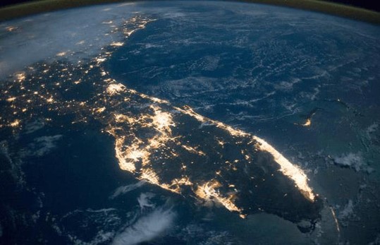
The Word on Global Warming: "It's Happening, It's Arrived." We've gone from theory to reality; we can measure rising seas. Here's an excerpt from The Sarasota Herald-Tribune: "For those who think climate change is a myth or a product of normal cyclical changes in the environment, University of Miami geological sciences professor Harold Wanless has a message: It’s already here. “The important thing to understand about global warming is: It’s happening, it’s arrived,” Wanless told about 150 people at University of South Florida Sarasota-Manatee’s Selby Auditorium Tuesday evening. “That’s where we are.” Wanless was the keynote speaker at the Suncoast Climate Change Symposium, which also featured the city of Sarasota’s sustainability manager, Stevie Freeman-Montes. The academic focused most of his talk on ocean warming and sea-level rise, two topics that are at the forefront of many Floridians’ minds. According to Wanless, 93.4 percent of global warming heat is accumulating in the oceans. By 2100, the world could see between 4.1 and 6.6 feet of sea-level rise, according to a model cited by Wanless developed by the National Oceanic and Atmospheric Administration in partnership with other organizations..." (File image: NASA).
- The deadly 2003 European heat wave, which killed more than 20,000 people, was the first major focus of an attribution study. The lead scientist reanalyzed the data in 2011. The heat wave is now thought to have been responsible for about 64 deaths in London and 506 in Paris.
- Heavy rain in southern Louisiana last August was studied by the World Weather Attribution project, which concluded that global warming had upped the odds considerably. By contrast, the central European flooding of May and June 2013 showed no such human fingerprints [see page S69 here: pdf].
- An April 2015 study in Nature Climate Change found that about 75 percent of major heat events and 18 percent of heavy precipitation events are attributable to global warming..."
… I reali[z]ed that co2 has an extremely long lifespan in the atmosphere compared to these other gases, and it’s the only one that we are directly responsible for producing via fossil fuels etc.Another prevalent science-assisted conclusion was the ever-increasing evidence that the climate is changing. "The relentless accumulation of data finally became inescapable. The amount of measurable, observable proof was just too much to ignore. For me it was when I saw a simple chart – world temp and world CO2 levels, on [a] marked timeline..."
Antarctica Meltwater Rivers Raise Concerns About the Fate of the Continent.
We still don't know what we don't know. But getting a handle on melting
is critically important when it comes to predicting the rate of future
sea level rise. Here's an excerpt from Nexus Media: "...Recently,
however, Greenland has started melting from the middle. Pools of water
are forming atop the ice sheet in the warmer months and then draining
out to sea. Scientists have now discovered the same thing is happening
in Antarctica. Two new studies published in the journal Nature catalogue the melting and explain what it could mean for sea-level rise. In the first study,
researchers examined decades of photos from satellites and military
aircraft. They documented hundreds of meltwater channels around the
perimeter of the continent. They traced some streams deep into
Antarctica’s frozen interior and discovered ponds of meltwater more than
4,000 feet above sea level, where no one expected to find liquid H2O..."
Image credit: "The Nansen Ice Shelf in Antarctica." Source: C. Yakiwchuck/European Space Agency
How a Melting Arctic Changes Everything. Bloomberg has an effective info-graphic and explainer on why we should all be paying close attention to changes in the Arctic: "...Sea
ice has diminished much faster than scientists and climate models
anticipated. Last month set a new low for March, out-melting 2015 by
23,000 square miles. Compared with the 1981-2010 baseline, the average
September sea-ice minimum has been dropping by more than 13 percent per
decade. A recent study in Nature Climate Change estimated that from
30-50 percent of sea ice loss is due to climate variability, while the
rest occurs because of human activity. Receding ice decreases the
Earth’s overall reflectivity, making the Arctic darker and therefore
absorbing even more heat..."
Graphic credit: Danish Meteorological Institute and Nico Sun
No comments:
Post a Comment