Spring Has Sprung
Signs of spring are becoming more and more evident across the region as perennials are already sprouting and tree buds are getting ready to pop. Keep in mind that the average lilac bloom date is around the 2nd week of May, which isn't far away. Pretty soon you'll be able to fire up the lawn mower and we'll be furiously swatting at skeeters! Enjoy the summer build up, the anticipation is palpable!

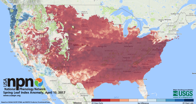
Spring Leaf Index Anomaly
According to the USA National Phenology Network, the spring leaf index anomaly suggests that spring has arrived up to 20 days earlier than normal across much of the nation! What is the spring leaf index? Here's an excerpt from USA NPN: "It is the appearance of the first tiny leaves on the trees, or the first crocus plants peeping through the snow? The Spring Leaf Index is a synthetic measure of these early season events in plants, based on recent temperature conditions. This model allows us to track the progression of spring onset across the country."
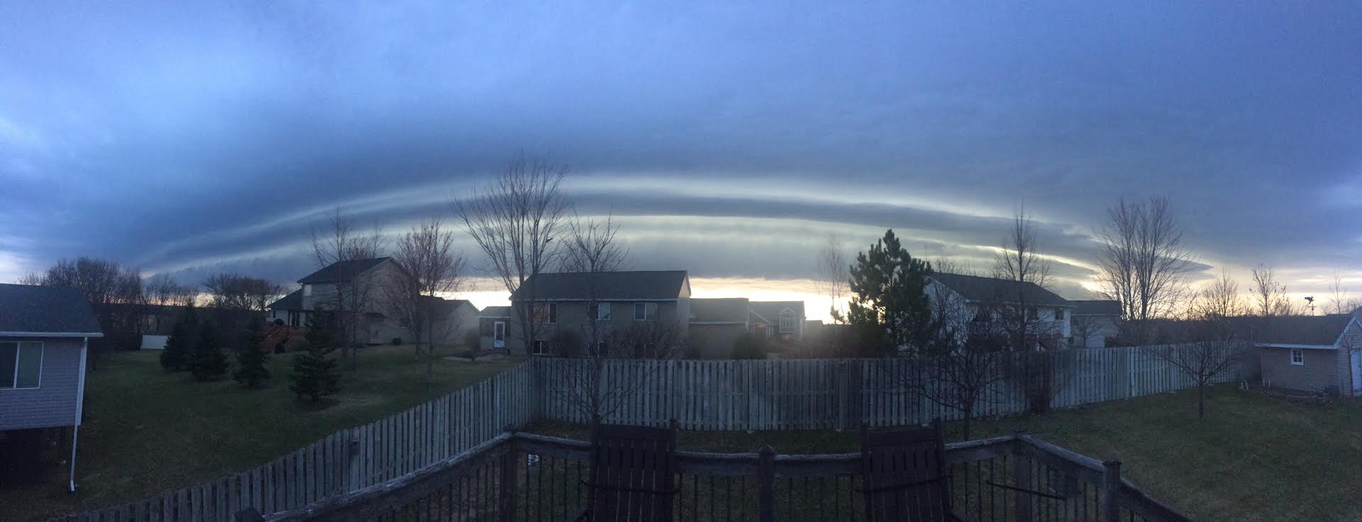
Sunday's Thunderstorm Activity
A few strong to severe storms developed across parts of the southern half of Minnesota and into Wisconsin PM Sunday. Here's an image of one of the storms that rolled through the northern Metro, which stayed sub-severe. This particular storm was responsible for gusty winds and some small hail.
Storm Reports Sunday
While there were very many storm reports across Minnesota, there were a few strong storms that developed in southeastern Minnesota that moved into central Wisconsin late Sunday. These storms were responsible for large hail and damaging wind reports there.

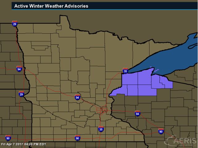
Winter Weather Advisory
A Winter Weather Advisory has been issued for parts of Northwest Wisconsin through 7AM Tuesday for the potential of 2" to 4" of slushy snow.
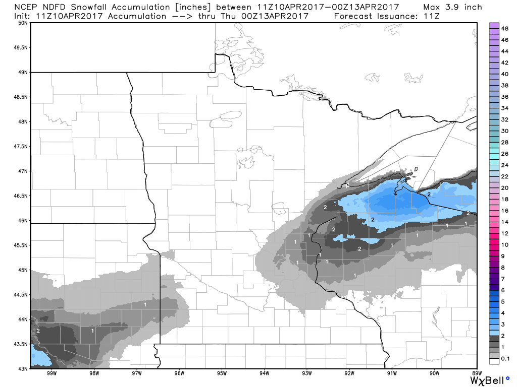
Snowfall Potential
Here's the snowfall potential through Tuesday, which suggests some 2" to near 4" tallies across parts of Northwest Wisconsin, while a slushy coating maybe possible just north of the Metro.
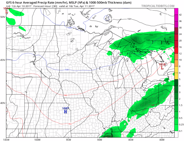
Precipitation Chances Continue This Week
Here's the weather outlook through AM Saturday, which shows another batch of precipitation moving into the Upper Midwest on Wednesday and once again late Friday/early Saturday.
_______________________________________________________________________
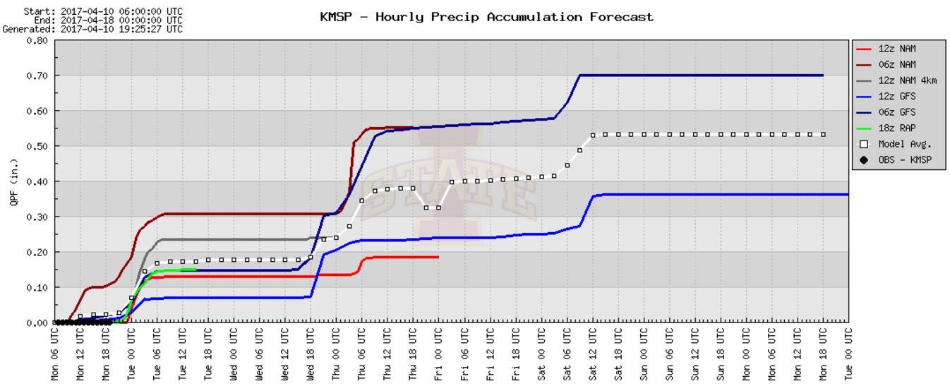
Precipitation Potential
Here's the precipitation potential into early next week. While the average suggests nearly 0.5", there is a chance that we could see nearly 0.7" in addition to what we had on Monday.
____________________________________________________________________
Record Warmth in the Northeast on Tuesday
Tuesday will be an exceptionally warm day in the Northeast with readings nearly 15F to 20F+ above average. Boston, Mass. is forecasting a high temperature of 81F while the record for April 11th is 78F, which was set in 1955.
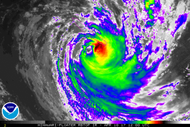
Tropical Cyclone COOK
Tropical Cyclone Cook continues in the South Pacific where earlier this week it created flooding in Vanuatu's central islands and hit New Caledonia's main island. Interestingly, Cook became the first cyclone to directly hit New Caledonia since 2003! Note that this is spinning anti-cyclonically because it is in the southern hemisphere!
Tracking Cook
Here's the forecast for Cook over the next several days. The good news is that Cook looks to move into open waters and away from any major landmass.

"Category three Cyclone Cook hits New Caledonia"
"French media reports at least four injured and 20,000 homes without power in the wake of Cyclone Cook making landfall in New Caledonia. Cyclonic winds and heavy rain buffeted the French island territory in the South Pacific on Monday, prompting residents to seek shelter and halt mining of nickel, its most important export. Local rainfall of up to 300 mm was also reported. "Right now we are in the eye of the storm, it is calm, but before the wind was strong and the rain was heavy," David Sigal told Reuters as he sheltered in the town hall of Poindimie, about 50 km north of where the storm hit land."
(Credit: 1NEWS via Stuff.co.nz)

__________________________________________________________________
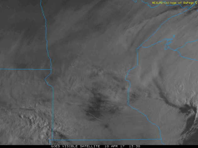
Visible Satellite on Monday
Monday was another cloudy day across much of the state, which featured areas of cold rain mixed with scattered snow showers late in the day. The good news is that sun will return Tuesday with highs back to near average. 60s look to return through the second half of the week and a near 70F high again by Saturday!
 ___________________________________________________________________________
___________________________________________________________________________
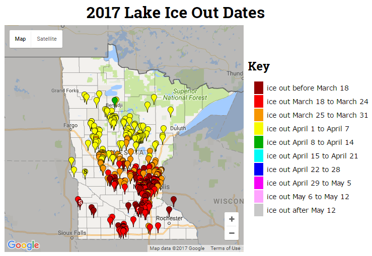
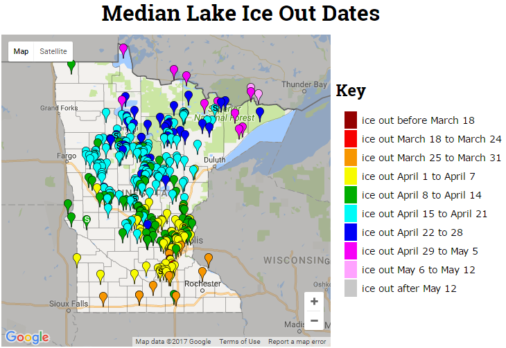
2017 Ice Out Dates
Here's the latest MN DNR ice out dates, which shows that more lakes across central and now northern MN have officially gone out for the season. Note that ice outs are occurring nearly 1 to 2 weeks ahead of schedule this year!
___________________________________________________________________________
Active Early Week
Here's the weather outlook through AM Friday, which shows an ongoing thunder threat from the Great Lakes to the Southern Plains on Monday. A few of these storms could be a little on the strong to severe side with locally heavy rainfall. Meanwhile, more Pacific moisture will feed into the Western US with locally heavy rainfall and mountain snow.
.gif)
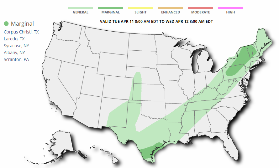
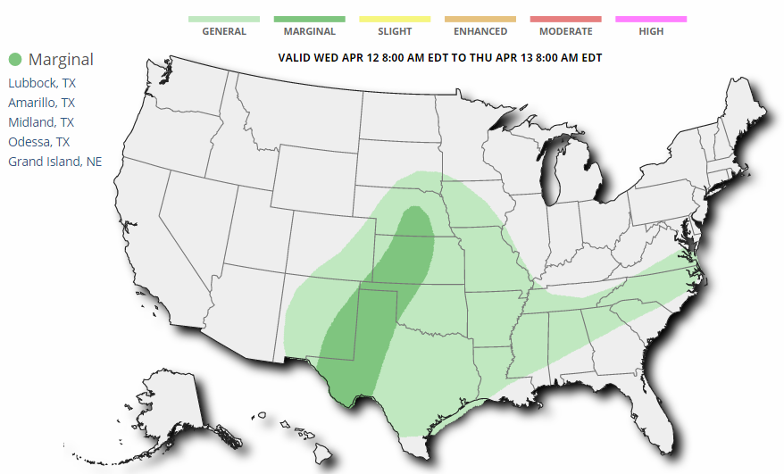
Several Weather Threats Ahead
While severe weather threats don't look quite as impressive as they did over the last could of weeks, there certainly will be a chance of some isolated strong to severe storms over the next couple/few days. Here's the severe weather threat for Tuesday and Wednesday respectively.
_________________________________________________________________________
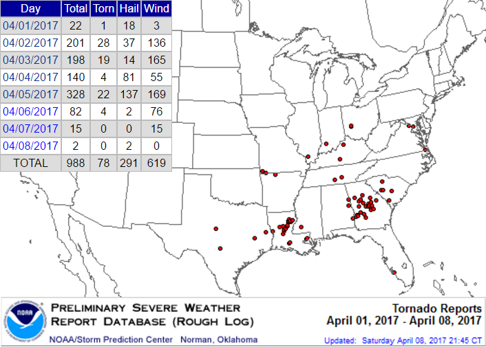
Active Start to April
According to NOAA's SPC, there have been nearly 1,000 severe weather reports through April 8th! While most of the reports have been either hail or wind reports, 78 of those have been tornadoes!
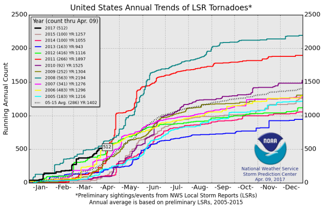
 2017 PRELIMINARY Tornado Count
According to NOAA's SPC, the PRELIMINARY tornado count for 2017 is at 512 (thru April 9). Interestingly, this is the highest number of tornado reports (thru April 9) since 2008 when 563 tornadoes were reported through that time frame. The 2005-2015 average number of tornado reports through April 9 is 286.
2017 PRELIMINARY Tornado Count
According to NOAA's SPC, the PRELIMINARY tornado count for 2017 is at 512 (thru April 9). Interestingly, this is the highest number of tornado reports (thru April 9) since 2008 when 563 tornadoes were reported through that time frame. The 2005-2015 average number of tornado reports through April 9 is 286.
 ________________________________________________________________
While severe weather threats don't look quite as impressive as they did over the last could of weeks, there certainly will be a chance of some isolated strong to severe storms over the next couple/few days. Here's the severe weather threat for Tuesday and Wednesday respectively.
_________________________________________________________________________
Active Start to April
According to NOAA's SPC, there have been nearly 1,000 severe weather reports through April 8th! While most of the reports have been either hail or wind reports, 78 of those have been tornadoes!
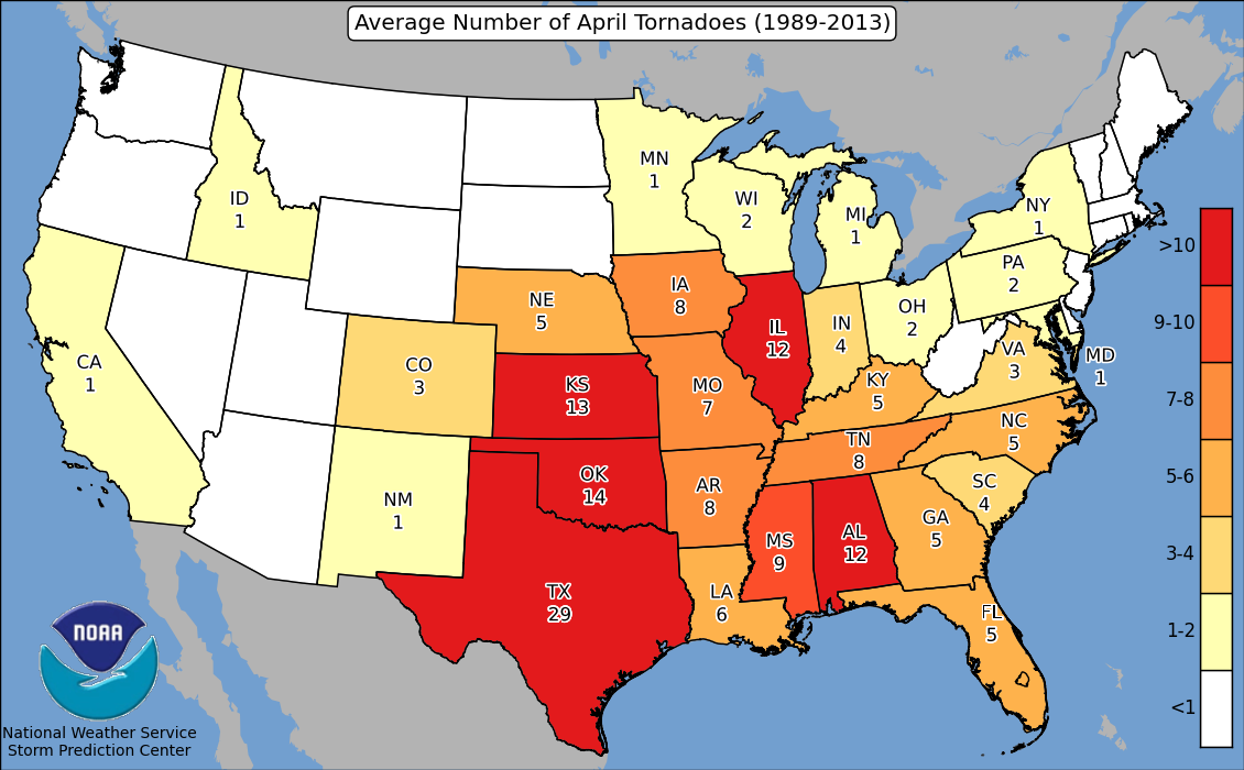
Average Number of April Tornadoes by State
According to NOAA's SPC, here are the average number of April tornadoes by state. Note that Texas averages nearly 30 tornadoes, while California and Idaho, surprisingly, average 1!
Slush or 90s? A Minnesota April Can Go Either Way
I find it charming and vaguely amusing when people in other (duller) zip codes around the United States share weather stories. The Plains see bigger tornadoes; the Gulf coast experiences Texas-size hurricanes. But when it comes to wild extremes look no further than Minnesota.
The biggest temperature swings take place near the center of continents, well away from the moderating effects of water. April can bring over a foot of snow in a single day - and 90s. Floods, blizzards, wildfires, shrieking tornadoes and boots full of slush! The MSP metro sees an average of 2.4 inches of snow in April. Morning slush this time of year is business as usual.
Any wintry memories give way to blue sky and low 50s Tuesday, a baby-step in the right direction. Showery rains brush Minnesota Wednesday, with heavier T-storms popping on Friday ahead of a warmer front. If everything goes just right we may sample 70 degrees Saturday afternoon as we stagger into spring.
April extremes? Absolutely. But still no earthquakes, tsunamis or volcanoes. The weather may be volatile but the ground underfoot is firm.
______________________________________________________________________________
Extended Forecast:
TUESDAY: Partly sunny. Better. Winds: NW 5-10. High: 53
TUESDAY NIGHT: Mostly clear and quiet. Winds: W 5. Low: 39.
WEDNESDAY: More clouds. A few showers nearby. Winds: S 8-13. High: 59.
THURSDAY: Intervals of sun, a nicer day. Winds: E 7-12. Wake-up: 43. High: 62.
FRIDAY: Showers likely. A few t-storms. Winds: SE 10-20. Wake-up: 47. High: 61.
SATURDAY: Damp start, then some mild PM sun. Winds: W 7-12. Wake-up: 57. High: 69.
SUNDAY: Partly sunny, a bit cooler. Winds: NW 8-13. Wake-up: 47. High: 60.
MONDAY: Fading sun, closer to average temps. Winds: SE 7-12. Wake-up: 38. High 58.
_______________________________________________________________________________
_______________________________________________________________________________
This Day in Weather History
April 11th
April 11th
1929: An intense downpour occurs in Lynd, Minnesota (near Marshall), where 5.27 inches of rain would fall in 24 hours.
_______________________________________________________________________________
_______________________________________________________________________________
Average High/Low for Minneapolis
April 11th
April 11th
Average High: 56F (Record: 83F set in 1968)
Average: Low: 35F (Record: 12F set in 1940)
Average: Low: 35F (Record: 12F set in 1940)
*Record Snowfall: 5.7" set in 1929
_______________________________________________________________________________
_______________________________________________________________________________
Sunrise Sunset Times For Minneapolis
April 11th
April 11th
Sunrise: 6:34am
Sunset: 7:53pm
Sunset: 7:53pm
*Daylight Gained Since Yesterday: ~3 minutes & 2 seconds
*Daylight Gained Since Winter Solstice (December 21st): ~4 hours & 35 minute
________________________________________________________________________________
*Daylight Gained Since Winter Solstice (December 21st): ~4 hours & 35 minute
________________________________________________________________________________
Moon Phase for April 10th at Midnight
0.0 Days after Full Pink Moon
0.0 Days after Full Pink Moon
Why is it the full pink moon? Here's an excerpt from Space.com: "April 11, 2:08 a.m. EDT – Full Pink Moon. The grass pink orchid, or wild ground phlox, is one of the earliest and most ubiquitous flowers of spring. Other names were the Full Sprouting Grass Moon, the Egg Moon and — among coastal tribes — the Full Fish Moon when the shad come upstream to spawn. In 2017, this is also the Paschal Full Moon; the first full moon of the spring season. The first Sunday following the Paschal Moon is Easter Sunday, which indeed will be observed five days later on Sunday, April 16."

________________________________________________________________________________
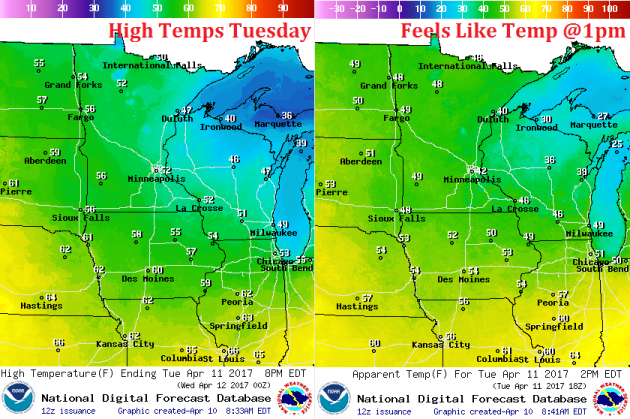
Weather Outlook For Tuesday
High temperatures on Tuesday will be a little warmer than they were on Tuesday. After a bit of a chilly start, we should have no problem getting back into the 50s across much of the state. A few 40s may linger across the Arrowhead and across northern Wisconsin, but we're heading in the right direction!
Weather Outlook For Tuesday
Winds subside quite a bit on Tuesday and switch out of the west. By Wednesday, winds will be out of the south and it might be just enough to get us close to 60F once again.