"May The Fourth Be With You" (May 4th)
Happy Star Wars Day! What better way to celebrate by owning a solid gold Darth Vader helmet? Hey, why not? This incredible piece of art is being sold by a Japanese Jeweler for a measly 1.4-million dollars. While many Star Wars fans will be celebrating "May the Fourth be with you" today, a few more may be celebrating "Revenge of the Fifth" tomorrow (May 5th).
"The force is strong with this one. And expensive, too. Looking to drop $1.4 million? Step right up to this counter where you can purchase a Darth Vader mask made of solid gold. Japan's jeweler Tanaka Kikinzoku Jewelry, founded in 1885, is selling the 33-pound pure gold mask to commemorate the 40th anniversary of the Star Wars film franchise. The pure gold mask will go on sale on May 4 – also known as Star Wars Day because it sounds like "May the Fourth" be with you. If $1.4 million is a little out of your price range, the jeweler will also be offering a commemorative plaque featuring three small oval coins made of pure gold. But act fast. There are only 77 plaques available, tied to mark 1977, the year the first film was released in theaters."

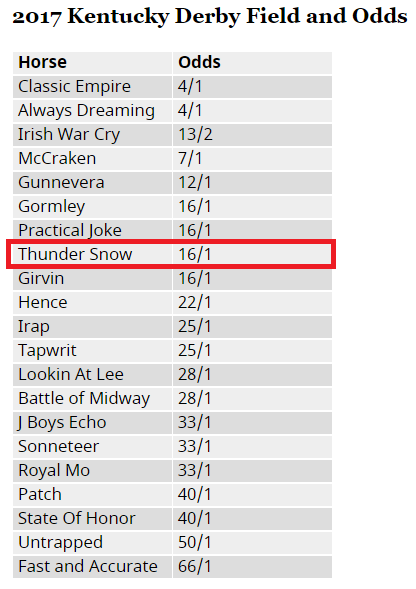
"Thunder Snow in peak form for Kentucky Derby"
I am not much of a gambler, but if I were, I'd have to put my money down on this horse... simply because of the name! Thunder Snow!! Really? Yes please! Early odds have Thunder Snow at a 16-1 chance, which is in the top half of the pack! GO THUNDER SNOW!!
"There's a 100% chance of Thunder Snow at Saturday's Kentucky Derby at Churchill Downs in Louisville (barring a late scratch) as a horse with that name has entered the race. Thundersnow (which is one word in the meteorological world) is the winter weather phenomenon made famous by excitable Weather Channel meteorologist Jim Cantore. The winner of the UAE Derby in March in Dubai, “Thunder Snow is a colt of the highest class and I hope that he can step up in the Kentucky Derby” trainer Saeed bin Suroor said in a press release."

_______________________________________________________________________________
Weather Outlook for the Kentucky Oaks and the Derby
Weather conditions for the Kentucky Oaks and the Derby look a little unfavorable this year with steadier light rain on Friday and a few lingering showers on Saturday. Keep in min that temperatures will be running nearly 10F to 20F below average with highs in the mid to upper 50s.
________________________________________________________________
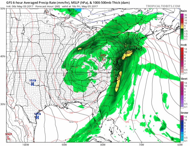
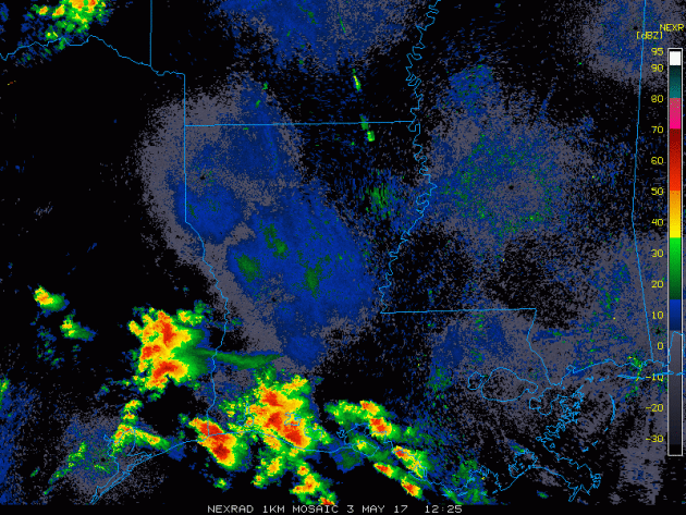
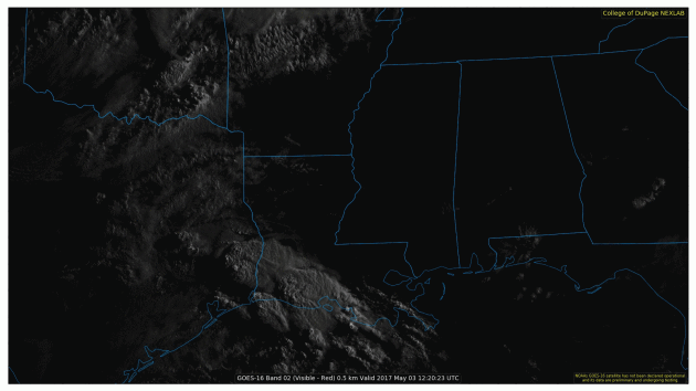
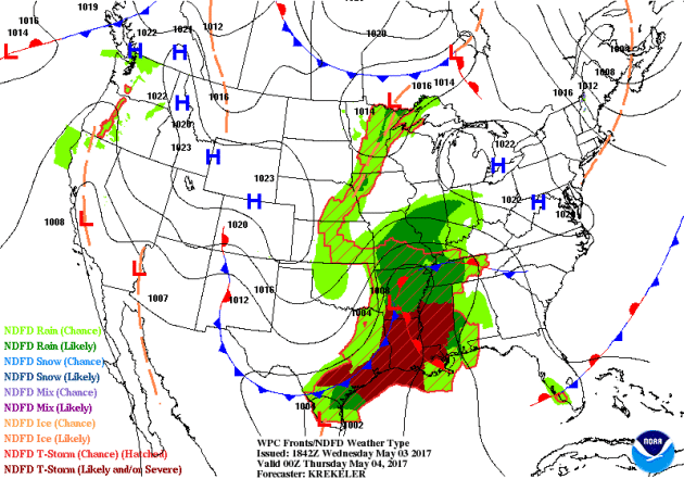
Stormy South on Wednesday
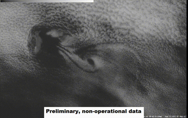
An ENHANCED RISK of severe weather was issued by the Storm Prediction Center across the Lower Mississippi Valley on Wednesday. Large hail, damaging winds, tornadoes and flooding rains were all possible. Take a look at the radar and visible satellite loops below from Wednesday morning, when a number of severe thunderstorm, tornado and flash flood warnings were in progress. Wednesday was a very active day across the Deep South that was expected to impact as many as 8 million people within the Enhanced Risk area.
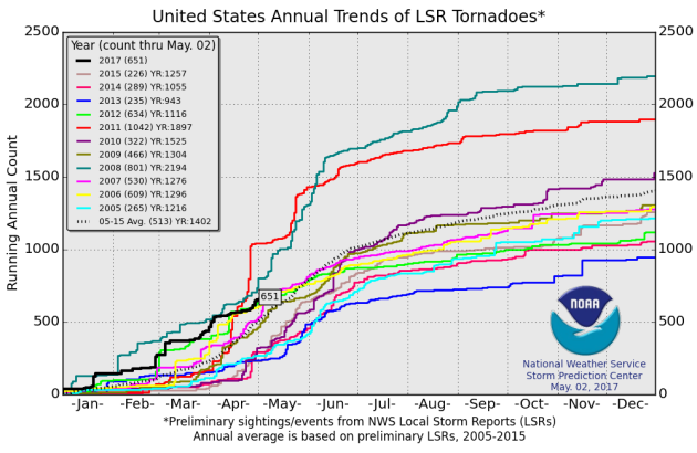
According to NOAA's SPC, the PRELIMINARY 2017 tornado count is 651 (through May 2). Note that is the most active year for tornadoes since 2011, when there were 1,000 tornadoes. Keep in mind there was a major tornado outbreak in the Gulf Coast region from April 25-28, 2011 that spawned nearly 500 tornadoes, some of which were deadly. That outbreak is known as the Super Outbreak of 2011 and has gone down in history as one of the biggest, costliest and one of the deadliest tornado outbreaks in history.
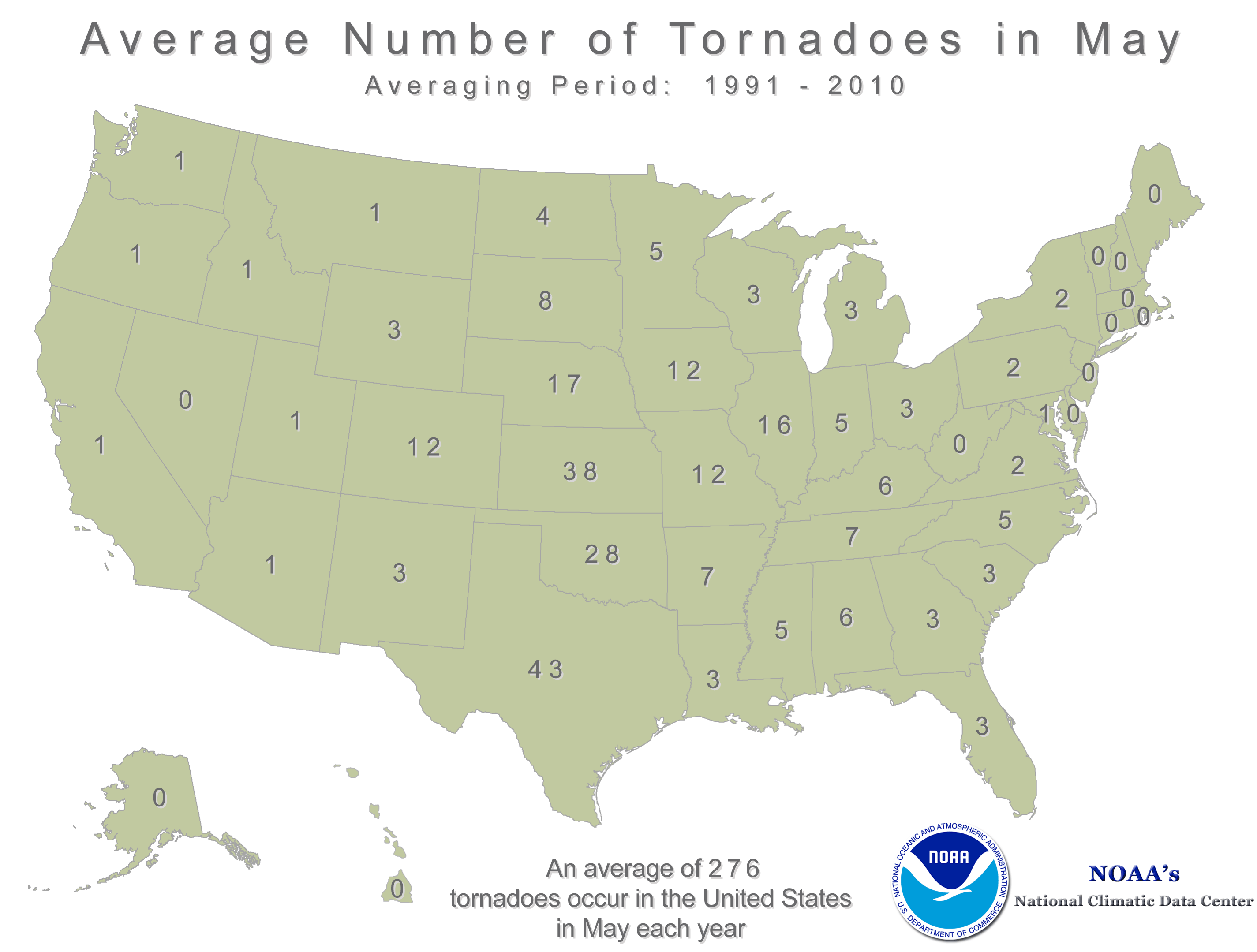
According to NOAA's NCDC, May is the busiest month for tornadoes across the country, averaging 276! Note that most of these tornadoes occur across the Plains from Texas to Nebraska, which is also in a region known as "Tornado Alley". As it stands now, April was the busiest tornado month of the year thus far with a preliminary total of 189. It is likely that several days of severe weather will break out at some point this month somewhere across the country, so stayed tuned!
_______________________________________________________________
Major River Flooding Continues
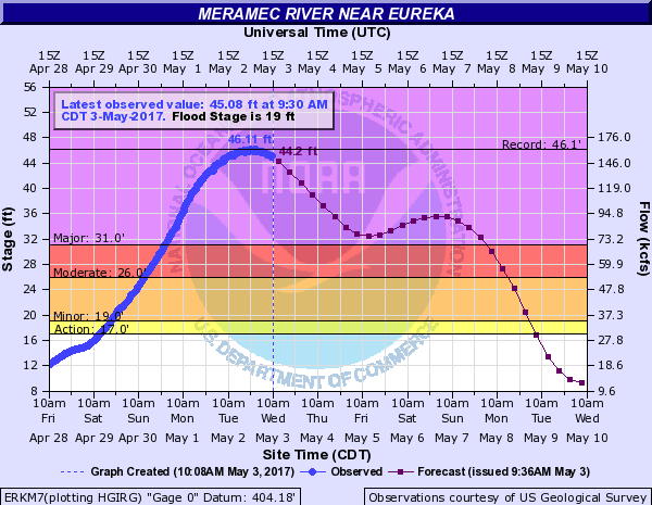
Take a look at the flooding taking place along the Meramec River near Eureka, MO! Aerial photos from Twitter: @PDPJ via STLtoday show significant flooding taking place there!
See @PDPJ on Twitter HERE:
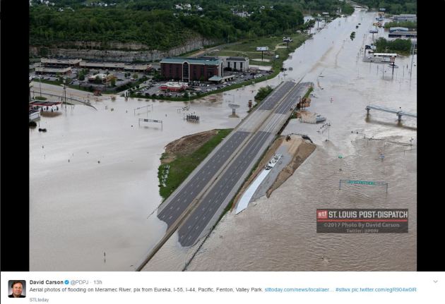
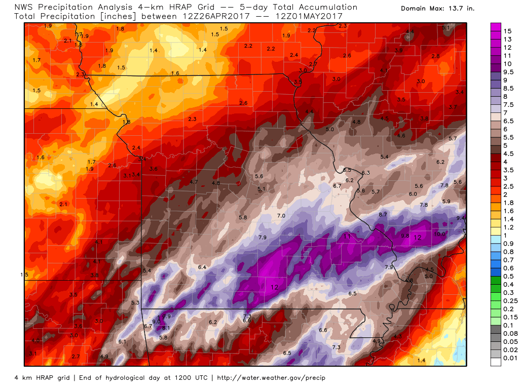
The images of the river flooding in the Central US are staggering as record and near record crests have been occurring in several locations. Here is the river gauge at the Meramec River near Eureka, MO, where a record crest occurred Tuesday night at 46.11 feet, besting the previous record crest of 46.06 feet on December 30, 2015.
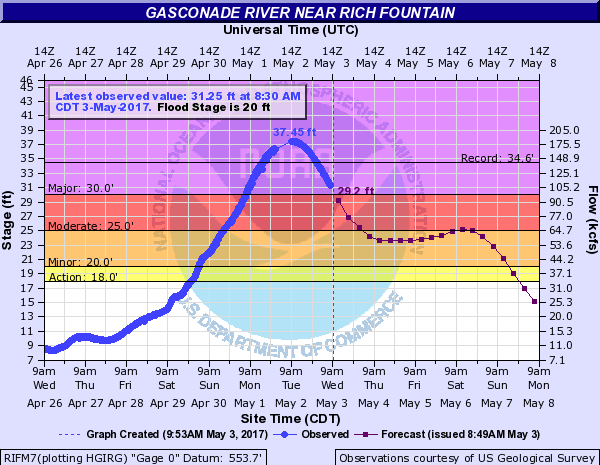
Several river gauges were at MAJOR flood stage as of Wednesday, some of which were at near very near record crests once again. Take a look at the Gasconade River in central Missouri, which peaked Tuesday at 37.45 feet, nearly 3 feet above the previous record stage on December 30, 2015!
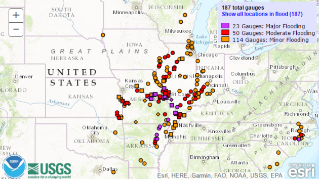
River Flooding Continues in the Central US
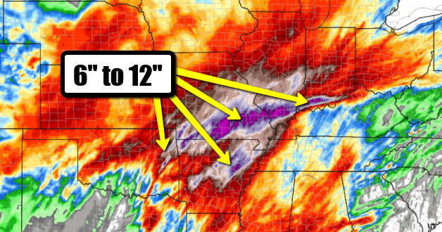
Enough already! Round after round of record rainfall has fallen across parts of the Central US since last week and that has caused several rivers to flood. According to NOAA, 23 river gauges were at MAJOR flood levels, while 50 gauges were at MODERATE flood levels. River flooding will likely continue over the next several days as the latest round of heavy rain works through the tributaries across the region.
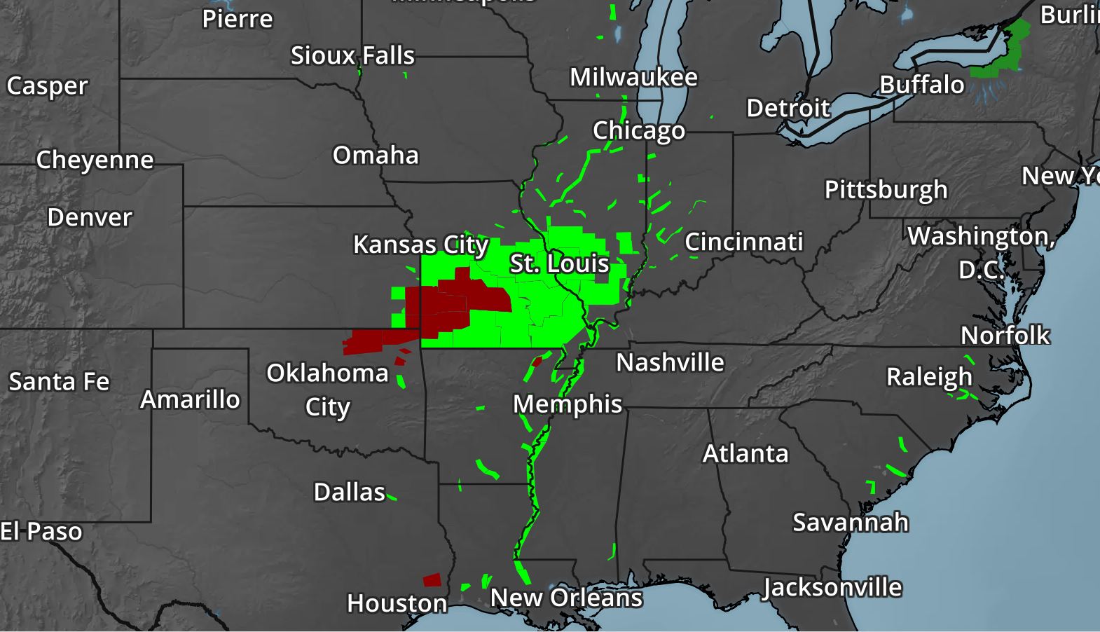
 Flood Warnings Continue
The National Weather Service continues Flood Warnings across a wide area of the Central US. River levels will remain high over the next several days, but should recede fairly quickly by the second half of the week. However, any additional rainfall could further exacerbate flood concerns, which could again be an issue with additional rainfall moving in later this week.
How Much Rain Fell?
Here's a look at how much rain fell across parts of Missouri since late last week. Note that radar estimates suggest nearly 10" of rain or more across the southern parts of Missouri and Illinois! Rainfall records fell on Saturday, here are some of the records:
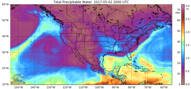
Another round of heavy rain midweek came by way of another surge of tropical moisture moving up from the Gulf of Mexico. You can see the brighter colors moving north into the Central part of the country in some of the same areas that were hit hard with heavy rain late last week and last weekend.
________________________________________________________________
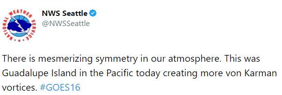
Von Karman Vorticies
WOW! This is cool! It's GOES16 visible satellite loop from Guadalupe Island in the Pacific Ocean from earlier this week. Thanks to the @NWSSeattle for the Twitter post!
A string of sunny days lasts through the weekend!
By Todd Nelson, filling in for Douglas.
By Todd Nelson, filling in for Douglas.
I am happy to report that the hair-raising weather from earlier this week will now be just a distant memory. From 3 to 6 inches of slushy snow accumulations to 70 degree high temps a few days later, Minnesotans are no stranger to wild weather that can prompt even the cleanest of mouths to spout insults toward your favorite meteorologist in the spring.
An "Omega" block develops across the country this weekend, which will help to keep several days of brilliant sunshine in our forecast today through early next week. High temperatures will once again return to normal levels and even flirt with 70 degrees by Friday. Meanwhile, both the Western and Eastern US will be stuck under cold and showery weather before the blocking patter finally breaks down next week.
Steadier rains will likely impact the Kentucky Oaks on Friday before turning more isolated for the 143rd running of the Kentucky Derby on Saturday. I am not a gambling man, but if I was, I'd have my money on Thunder Snow! With a name like that, what weather nut wouldn't?
_______________________________________________________
_______________________________________________________
Extended Forecast
THURSDAY: Few clouds. Very nice. Winds: N 5-10. High: 65.
THURSDAY NIGHT: Mostly clear and quiet. Nothing rough. Winds: N 5. Low: 44
FRIDAY: TGIF! Skip out of work early? Winds: WNW 5-10. High: 72.
SATURDAY: A touch cooler. Still brilliant Winds: ENE 5. Wake-up: 47. High: 64.
SUNDAY: More filtered sunshine. Near average temps. Winds: SE 5-10. Wake-up: 44. High: 65.
MONDAY: More clouds. A shot at 70F again. Winds: SE 5-15: Wake-up: 48. High: 70
TUESDAY: Mild. A few afternoon rumbles possible. Winds: SSE 5-10. Wake-up: 53. High: 73
WEDNESDAY: Spotty showers and storms. Winds: NNE 5-10. Wake-up: 55. High: 71
_______________________________________________________
_______________________________________________________
This Day in Weather History
May 4th
May 4th
1926: Morris goes from winter to summer temperatures in one day. The morning low was 32, followed by a high of 89.
________________________________________________________
________________________________________________________
Average High/Low for Minneapolis
May 4th
May 4th
Average High: 66F (Record: 91F set in 1952)
Average Low: 45F (Record: 22F set in 1967)
Average Low: 45F (Record: 22F set in 1967)
Record Snowfall: 2.0" set in 1980
__________________________________________________________
__________________________________________________________
Sunrise/Sunset Times for Minneapolis
May 3rd
May 3rd
Sunrise: 5:58am
Sunset: 8:22pm
Sunset: 8:22pm
Daylight gained since yesterday: ~2mins & 38secs
Daylight gained since winter solstice (December 21st): ~5hours & 39mins
__________________________________________________________
Daylight gained since winter solstice (December 21st): ~5hours & 39mins
__________________________________________________________
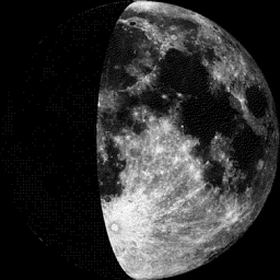
Moon Phase for May 3 at Midnight
1.2 Days Since First Quarter
1.2 Days Since First Quarter
_____________________________________________________________
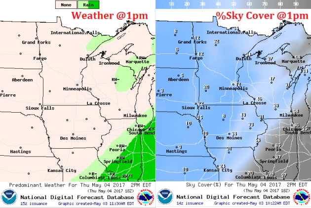
Weather Outlook For Thursday
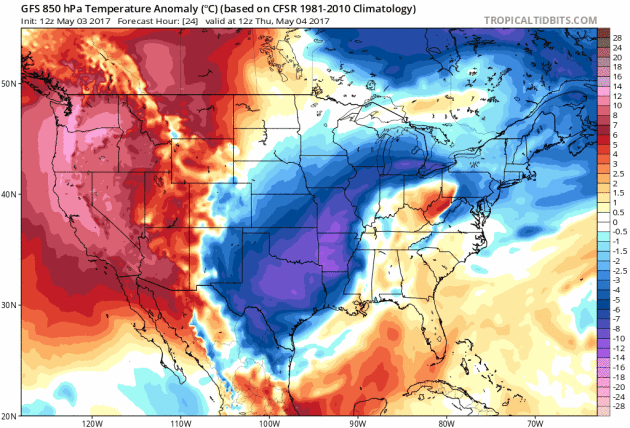
High temperatures on Thursday will return to near average levels close to home with readings back in the mid 60s. However, places east will be remain cooler than average and places west will be warmer than average with some across the Dakotas warming into the 70s.

Weather Outlook for Thursday
Winds will not be too big of an issue on Thursday with the exception of a few spots in extreme southern Minnesota. Locations there could see winds gusting to near 15 to 20mph.
Thursday will also be the first of several sunny days in a stretch right through the weekend. An upper level ridge will move overhead, which will help to keep skies clear over the next several days.
Quiet Weather Ahead
Here's the weather outlook from Thursday to Monday of early next week. After a very chilly and somewhat wintry start to the week, weather conditions will turn more sublime with temperatures closer to average through the weekend. The next best chance of precipitation doesn't move in until next week.
.gif)
_________________________________________________________________
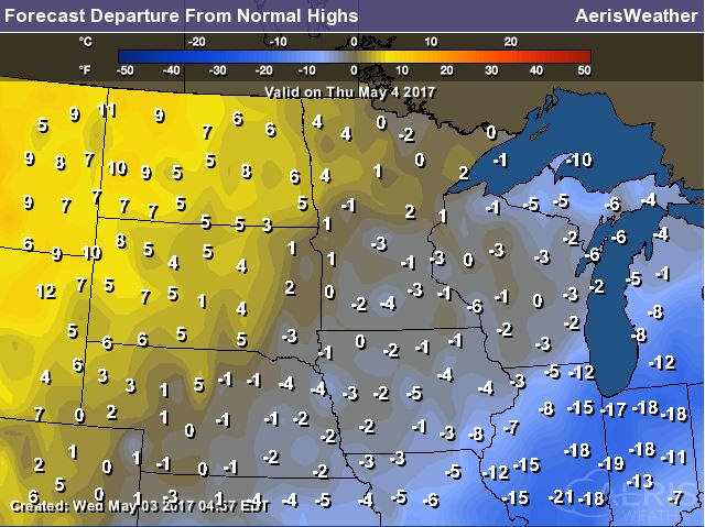
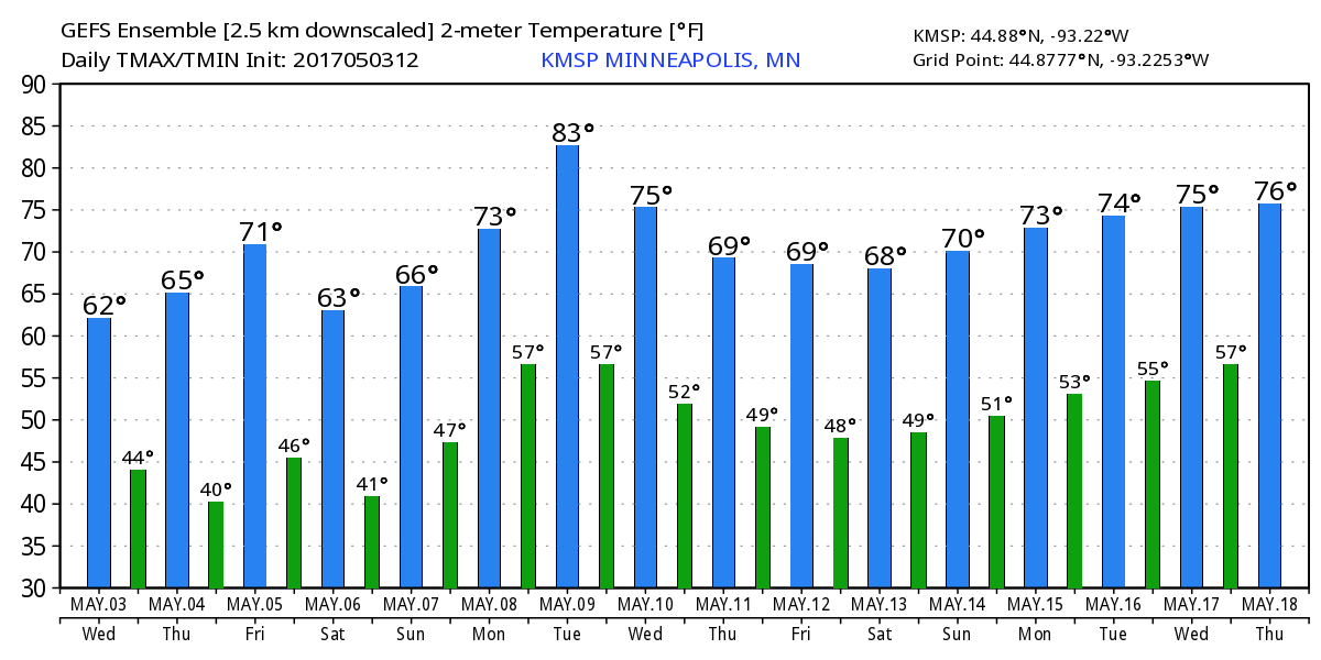
Temperature Outlook
Here's the temperature outlook through the middle part of May, which suggests warmer temperatures bubbling back into the region over the next couple of weeks. Note that there doesn't appear to be any major cool down in the foreseeable future, but we may have a few 70s possible.
8 to 14 Day Temperature Outlook
According to NOAA's CPC, the extended temperature outlook suggests warmer than average temperatures moving back into the Upper Midwest through the second week of May with highs warming into the 60s and 70s
___________________________________________________________
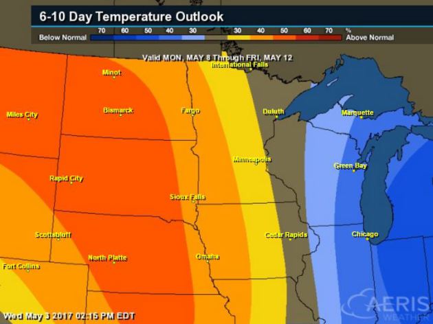
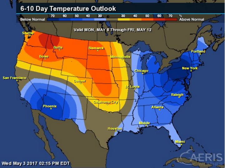
Extended Temperature Outlook
According to NOAA's CPC, the extended temperature outlook shows much cooler than average weather settling in across the Eastern and southwestern part of the country as we head into the second week of May. However, warmer than average temperatures will settle in across the Plains and the Northwest.
 ____________________________________________________________
Temperature Trend
Here's the temperature trend through the weekend and early next week. Note cooler than average temperatures look to linger across the eastern half of the country. Some of the coolest weather will be found across parts of the Northeast as we head into the 2nd week of May, while warmer than average temperatures look to move in across the western part of the country and eventually into parts of the Central US.
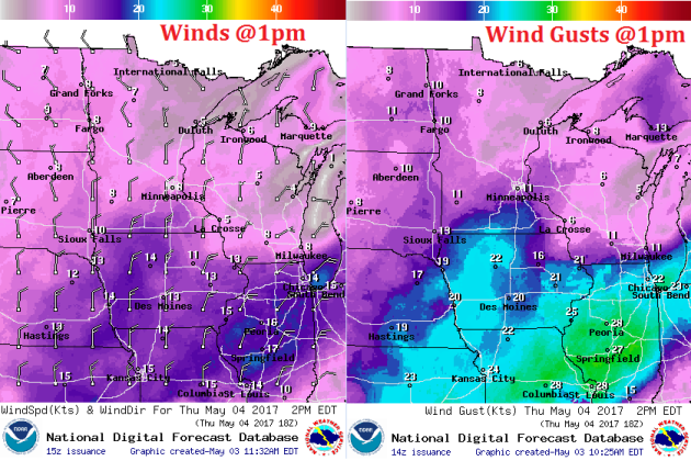
Another waterlogged storm system will move east into the Eastern US through the end of the week with spotty severe weather concerns across the Southeast and widespread heavy rain across the Ohio Valley, Great Lakes and Northeast. Meanwhile, cool and quiet weather moves into the Central US and more moisture slides into the Pacific Northwest.
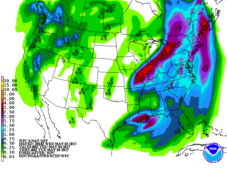
5 Day Precipitation Outlook
According to NOAA's WPC, the 5 day precipitation outlook continues to show fairly decent rainfall tallies across parts of the Central and Eastern US with some locations seeing nearly 2" to 3" or more that could lead to additional flood concerns through the end of the week.
"When climate scientists examine whether the warming of the Earth has made extreme weather events such as heatwaves or downpours more likely, they generally do it on a case-by-case basis. But a group led by Stanford climate scientist Noah Diffenbaugh has aimed to develop a more global, comprehensive approach to investigating how climate change has impacted such extremes. With a new framework they developed, Diffenbaugh’s team found that heat records were made both more likely and more severe for about 80 percent of the area of the globe with good observational data. For precipitation records, that percentage was about half. The team also examined a few particular events, finding, for example, that warming was clearly linked to the record-low summer Arctic sea ice extent of 2012."
See more from Salon HERE:
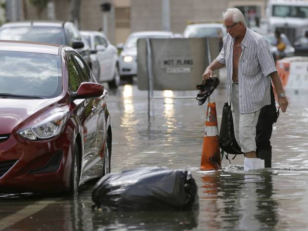
FILE - In this Sept. 30, 2015 file photo, a hotel guest carries his shoes as he is escorted to his car along in Miami Beach, Fla. The street flooding was in part caused by high tides due to the lunar cycle, according to the National Weather Service. A new scientific report finds man-made climate change played some kind of role in two dozen extreme weather events around the world in 2015. But it also detected no global warming fingerprints in a handful of other weird weather instances. (AP Photo/Lynne Sladky, File)(Credit: AP)
___________________________________________________________________________
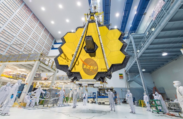
"A golden mirror for the next space telescope"
"The James Webb Space telescope, to be launched in 2018, will rely on this giant gold mirror to collect infrared light. The James Webb Space Telescope, an international project led by NASA along with the European and Canadian space agencies that is due to be launched in October 2018, will be the successor to the Hubble Space Telecope. The telescope will use a 6.5 meter gold mirror composed of 18 hexagonal segments to capture infrared light from distant stars and galaxies, giving new insights into the formation of galaxies in the early universe as well as the dust clouds where stars and planets are still forming today."
(The massive gold mirror that will form the eye of the James Webb Space Telescope.
NASA/DESIREE STOVER)
NASA/DESIREE STOVER)
_______________________________________________________________________
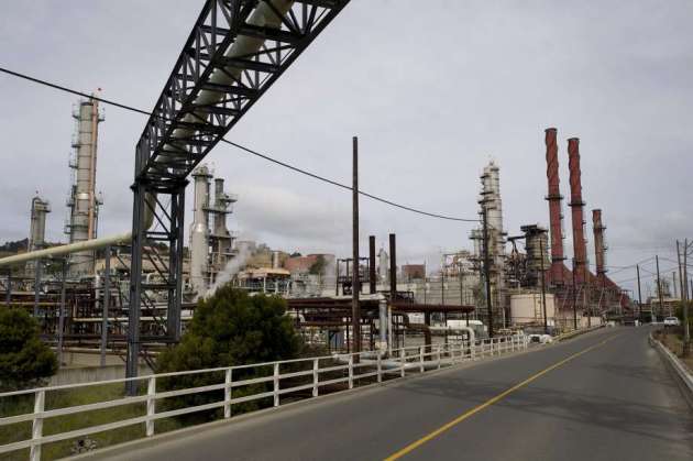
"New bill would help California combat climate change"
"California’s cap-and-trade program, the crucial mechanism for California’s fight against climate change, is facing stiff headwinds. The California Chamber of Commerce filed a lawsuit against the program years ago, challenging the program’s legality because it functions like a tax but did not receive a two-thirds vote in the state Legislature. That lawsuit is still working its way through the courts. Meanwhile, the state has struggled to find the right fiscal balance between the demands of selling permits and easing businesses into the need to pay for their greenhouse gas emissions. The state has given away free permits and struggled to sell large percentages of the permits in recent auctions. And while companies enjoy the ability to purchase offset credits for green projects like forest preservation, in exchange for their emissions, environmental activists in the state’s most polluted areas say the program hasn’t done nearly enough to help them."
(Photo: David Paul Morris, Bloomberg via SFChronicle.com)
_______________________________________________________
"How the Internet of Things can fight climate change"
"Last year was the warmest year globally on record, and global temperatures continue to rise because of climate change. By 2050, greenhouse gas emissions must be reduced by 40 to 70 percent below the levels they were at in 2010 to limit global warming by two degrees Celsius according to the United Nations Intergovernmental Panel on Climate Change (IPCC). If we fail to accomplish this, it could be extremely dangerous for the planet, scientists say. A recent report by Ericcson indicates that the IoT will be responsible for a 63.5 gigaton reduction in greenhouse gas emissions by 2030. This will be due in part to opportunities for collaboration between various industries leading to efficiencies that weren’t possible before the rise of the IoT. Some specific examples of how IoT will combat climate change include:"

__________________________________________________________
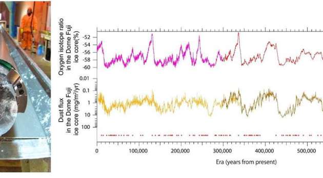
"Climate instability over the past 720,000 years"
"A research group formed by 64 researchers from the National Institute of Polar Research, the University of Tokyo, and other organizations has analyzed atmospheric temperatures and dust for the past 720,000 years using an ice core obtained at Dome Fuji in Antarctica. Results indicate that when intermediate temperatures occurred within a glacial period, the climate was highly unstable and fluctuated. A climate simulation was also performed based on the Coupled Atmosphere-Ocean General Circulation Model, which revealed that the major cause of the observed climate instability was global cooling caused by a decline in the greenhouse effect."
_______________________________________________________________________
"NASA to measure greenhouse gases over the Mid-Atlantic region in May"
"In May, a team of Goddard scientists will begin measuring greenhouse gases over the Mid-Atlantic region — an area chosen in part because it encompasses a range of vegetation, climate and soil types that would influence the exchange of carbon dioxide and methane between the Earth and the atmosphere. The airborne campaign, called the Carbon Airborne Flux Experiment, or CARAFE, could help scientists better understand the exchange process, also known as flux, and improve computer models that predict Earth’s carbon sinks, natural or artificial areas that absorb carbon dioxide or methane."
The Wallops Flight Facility Aircraft Office operates the NASA C-23 Sherpa research aircraft available to support airborne science research. The C-23 is a two-engine turboprop aircraft designed to operate under the most arduous conditions, in a wide range of mission configurations. Credit: NASA.)

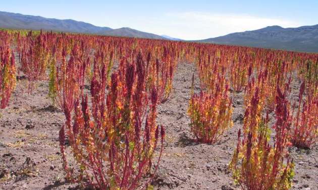
"How ancient crops could counteract climate change effects"
Farmers who grow single crops are particularly vulnerable to the effects of climate change, but now researchers are resurrecting ancient crop varieties to encourage diversity and offset the risks of extreme weather. Intensively growing single crops for commercial purposes is the most common farming practice in Europe. These so-called cash crops include corn and wheat and they depend on stable weather to get a good harvest. 'With climate change we will see much more drought in different places of the world, especially in the Mediterranean region, and large parts of Africa,' said Professor Sven-Erik Jacobsen from the Department of Plant and Environmental Sciences at the University of Copenhagen, Denmark. 'Even in north Europe we will see more drought and heavier rainfalls.' An unusually hot or wet period could devastate harvests of traditional crops, but species originating in warmer climates could serve as a solution to European farmers under threat. 'These crops could be the answer to the climate change effects that we will experience more and more,' said Prof. Jacobsen, who is the project coordinator of PROTEIN2FOOD, an EU-funded project that's exploring ancient crops and legumes to help make modern agriculture more sustainable.
(Quinoa could become a staple crop for European farmers. Credit: PROTEIN2FOOD)
"About 40 kilometers off Michigan’s Keweenaw Peninsula, in the waters of Lake Superior, rises the stone lighthouse of Stannard Rock. Since 1882, it has warned sailors in Great Lakes shipping lanes away from a dangerous shoal. But today, Stannard Rock also helps scientists monitor another danger: climate change. Since 2008, a meteorological station at the lighthouse has been measuring evaporation rates at Lake Superior. And while weather patterns can change from year to year, Lake Superior appears to be behaving in ways that, to scientists, indicate long-term climate change: Water temperatures are rising and evaporation is up, which leads to lower water levels in some seasons. That’s bad news for hydropower plants, navigators, property owners, commercial and recreational fishers and anyone who just enjoys the lake. When most people think of the physical effects of climate change, they picture melting glaciers, shrinking sea ice or flooded coastal towns (SN: 4/16/16, p. 22). But observations like those at Stannard Rock are vaulting lakes into the vanguard of climate science. Year after year, lakes reflect the long-term changes of their environment in their physics, chemistry and biology. “They’re sentinels,” says John Lenters, a limnologist at the University of Wisconsin–Madison."
See more from ScienceNews HERE:
(ALPAMAYOPHOTO/GETTY via ScienceNews)

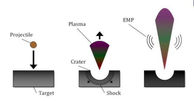
________________________________________________________________"Why Space Dust Emits Radio Waves Upon Crashing into a Spacecraft"
"When spacecraft and satellites travel through space they encounter tiny, fast moving particles of space dust and debris. If the particle travels fast enough, its impact appears to create electromagnetic radiation (in the form of radio waves) that can damage or even disable the craft's electronic systems. A new study published this week in the journal Physics of Plasmas, from AIP Publishing, uses computer simulations to show that the cloud of plasma generated from the particle's impact is responsible for creating the damaging electromagnetic pulse. They show that as the plasma expands into the surrounding vacuum, the ions and electrons travel at different speeds and separate in a way that creates radio frequency emissions."
See more from SpaceREF HERE:
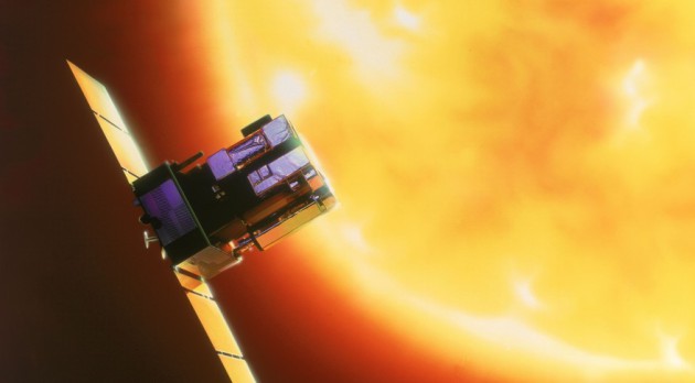
__________________________________________________________"Senate passes space weather bill"
"WASHINGTON — The Senate unanimously passed a bill May 2 intended to support space weather research and planning to protect critical infrastructure from solar storms. The Senate passed, via unanimous consent, the Space Weather Research and Forecasting Act. The bill cleared the Senate Commerce Committee in January, which had approved a similar bill in 2016. The bill is designed to outline roles and responsibilities for various U.S. government agencies to research, forecast and respond to space weather, which can affect communications, the power grid and other systems. It builds upon a national space weather strategy and action plan released by the Obama administration in October 2015."
See more from SpaceNews HERE:
(The space weather bill directs NOAA to plan for a replacement for the SOHO spacecraft, which provides critical imagery but is more than 20 years old. Credit: ESA via SpaceNews)
Thanks for checking in and don't forget to follow me on Twitter @TNelsonWX

No comments:
Post a Comment