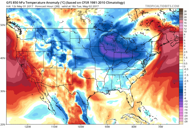
Flooding Waters Linger in the Central US
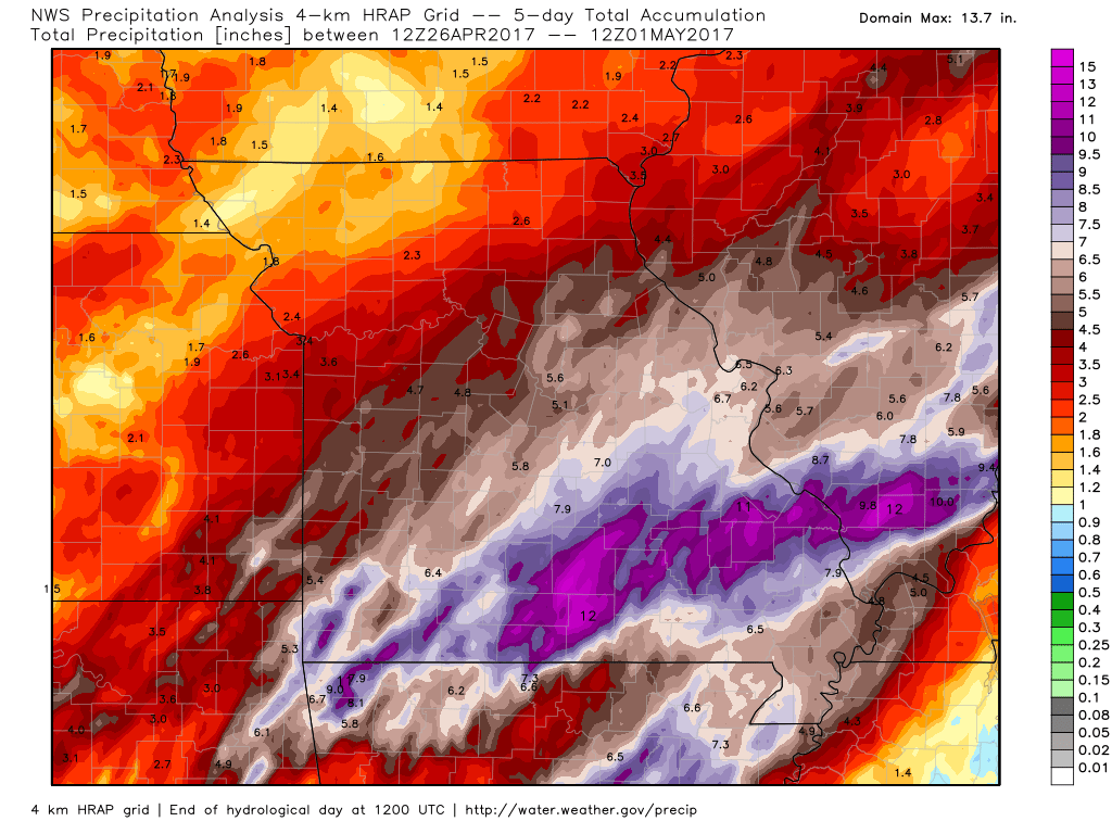
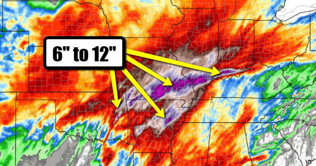
Take a look at the picture below from Van Buren, MO where the Current River crested early Monday at a height of 8.2 feet above the previous record crest set in 1904! Major flooding was the result of severe thunderstorms that developed and trained over the same areas through the weekend. Radar estimates suggest nearly 6" to 12" of rain over some spots over the last 5 days!
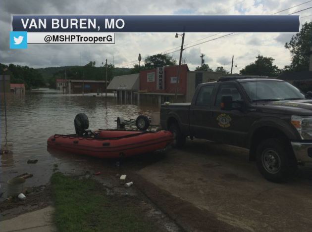
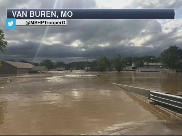
Record Crest Along Current River in Van Buren, MO
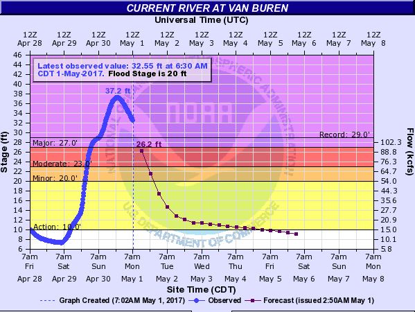
Several river gauges were at MAJOR flood stage as of Monday, some of which were even at record levels! Take a look at the Current River in southern Missouri, which peaked overnight at 37.2 feet, nearly 8 feet above the previous record stage on March 26, 1904!
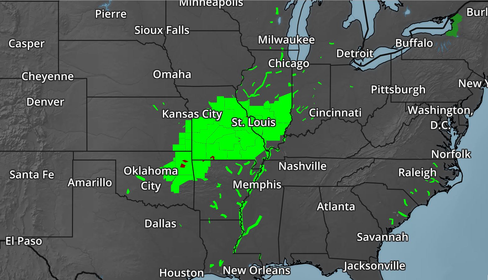
Major River Flooding
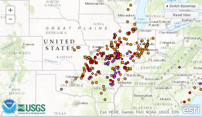
Thanks to significant rainfall from late last week and into the weekend, a number of rivers in the Central US are dealing with flooding. In fact, according to the National Weather Service, there are nearly 250 river gauges across the country that are in flood stage, 28 of which are at MAJOR flood stage, which is indicated by the purple dots.
Flood Warnings Continue
The National Weather Service continues Flood Warnings across a wide area of the Central US. River levels will remain high over the next several days, but should recede fairly quickly by the second half of the week. However, any additional rainfall could further exacerbate flood concerns, which could again be an issue with additional rainfall moving in later this week.
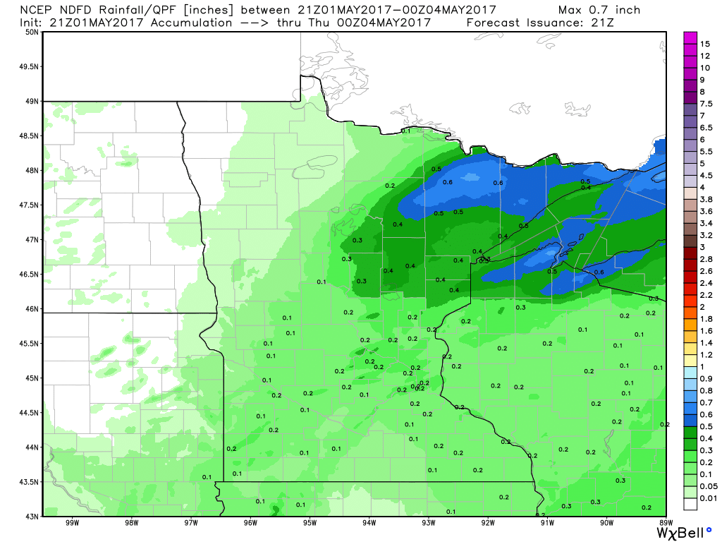
How Much Rain Fell?
Here's a look at how much rain fell across parts of Missouri from late last week into the weekend. Note that radar estimates suggest nearly 10" of rain across the southern parts of Missouri and Illinois! Rainfall records fell on Saturday, here are some of the records:
Springfield, MO: 4.31"
Joplin, MO: 4.52"
West Plains, MO: 6.94"
Rolla, MO: 3.36"
St. Louis, MO: 3.15"
Columbia, MO: 4.46"
Quincy, IL: 2.47"
Evansville, IN: 2.83"
Harrison, AR: 3.56"
Joplin, MO: 4.52"
West Plains, MO: 6.94"
Rolla, MO: 3.36"
St. Louis, MO: 3.15"
Columbia, MO: 4.46"
Quincy, IL: 2.47"
Evansville, IN: 2.83"
Harrison, AR: 3.56"
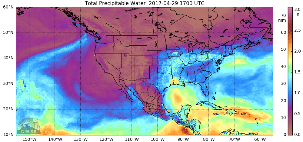
Why So Much Rain?
Excessive rainfall came by way of tropical moisture from the Gulf of Mexico. Here's an animation of the conveyor belt of moisture being drawn north into the Central US. The rainfall was enhanced by thunderstorms, which helps to produce heavy rainfall in a short amount of time.
________________________________________________________
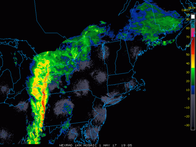
Severe Storms in the Eastern US on Monday
Monday, May 1st, featured another round of severe storms across parts of the Eastern US. The radar loop below from early Monday evening showed the line of strong to severe storms as they rumbled across parts of western New York and Pennsylvania.
________________________________________________________________
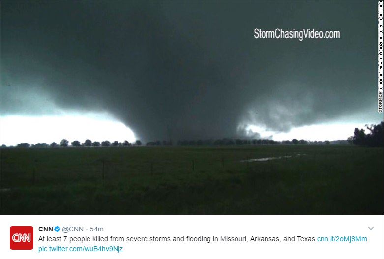
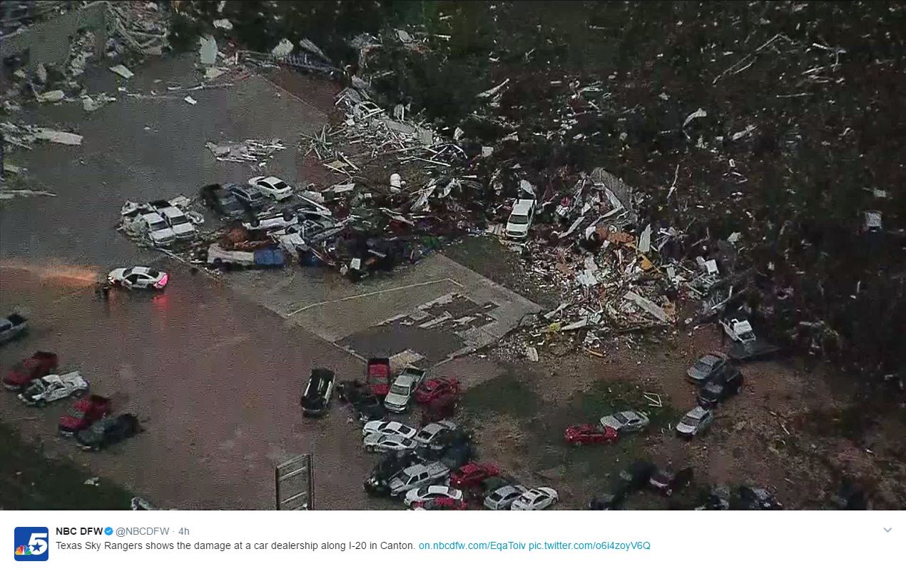
Wild Weekend Weather
From flooding rains to tornadoes, this weekend was exceptionally busy. Here's an image from @CNN (via StormChasingVideo.com) and @NBCDFW on Twitter that showed damage from a large tornado that ripped through Canton, TX.
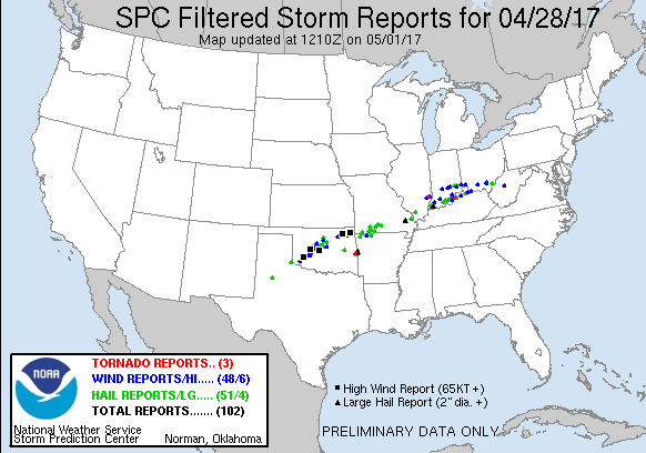
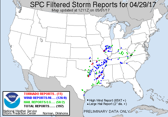
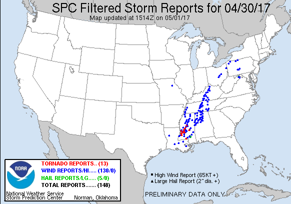
Severe Storm Reports Friday, Saturday & Sunday
It was an active end to April with several large hail, damaging wind and even tornadoes reports. In fact, according to NOAA's SPC, there were nearly 450 of severe weather across the country, which accounts for nearly 5.5% of the entire severe weather reports for the month of April.
 _____________________________________________________________________
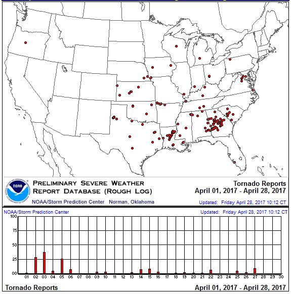
April Tornado Reports
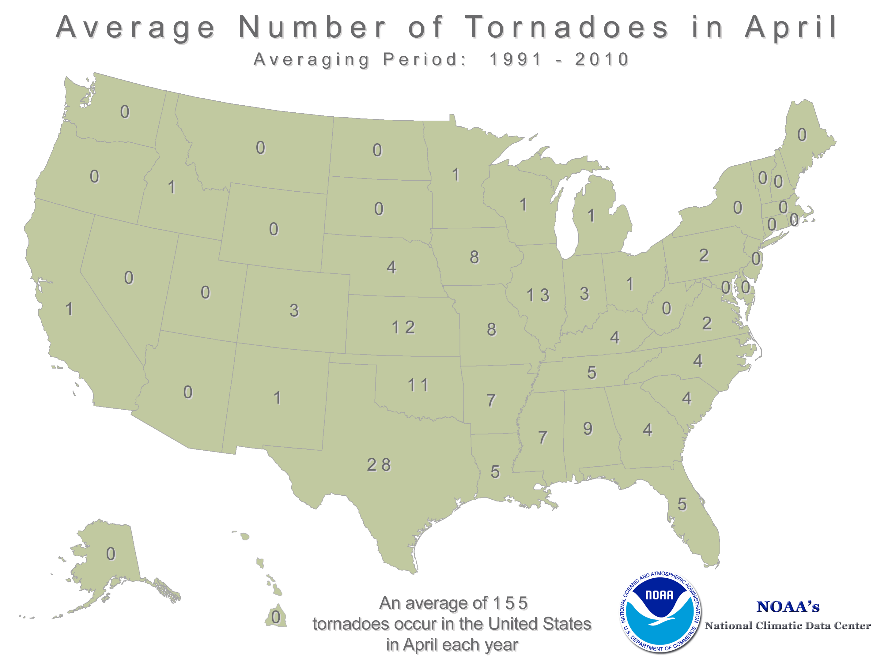
According to NOAA's SPC, there were nearly 180 tornado reports across the country during the month of April, which according to NOAA's NCDC is a little above the 1991-2010 average, which is 155.
Average Number of April Tornadoes
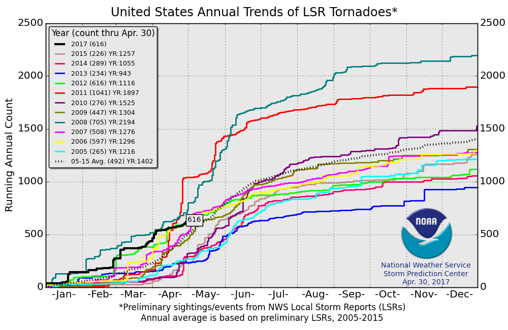
PRELIMINARY 2017 Tornado Count
According to NOAA's SPC, the PRELIMINARY 2017 tornado count is 616 (through April 30). Note that is the most active year for tornadoes since 2012 through the end of April, but also note that in 2011, there were more than 1,000 tornado reports! Keep in mind there was a major tornado outbreak in the Gulf Coast region from April 25-28, 2011 that spawned nearly 500 tornadoes, some of which were deadly. That outbreak is known as the Super Outbreak of 2011 and has gone down in history as one of the biggest, costliest and one of the deadliest tornado outbreaks in history.
________________________________________________________________
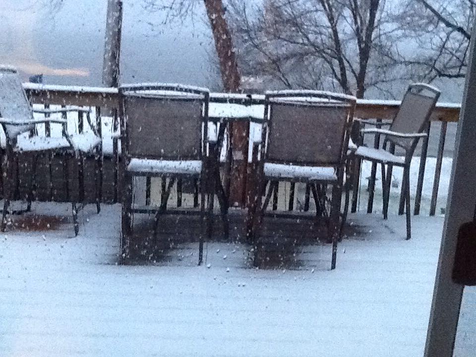
Snowy Start to May...
Thanks to Penny Shaw from Lake Osakis for the picture below, who woke up to a snowy scene on the first day of May. Penny wasn't too fond of this wintry weather as the docks are in and they'd rather be fishing! Sorry Penny! I take no responsibility for that weather nonsense.
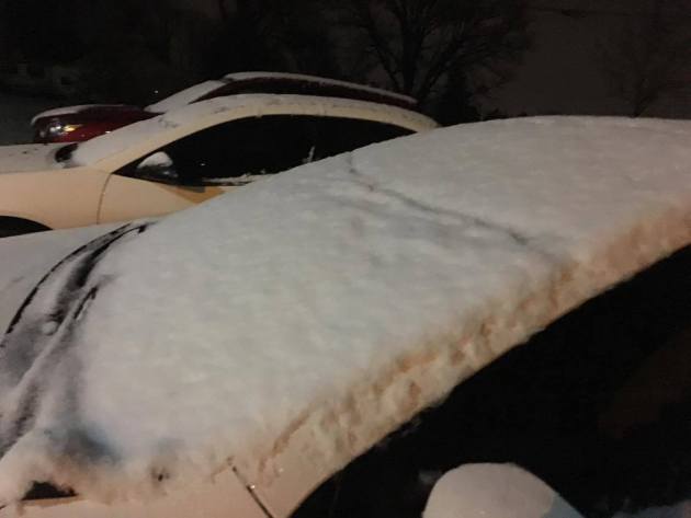
Snowy Start in Sartell, MN
Thanks to @dkayserwx for the picture below who, for the 2nd week in a row, woke up to wintry weather in Sartell, MN. The good news is that this won't stick around long. Much of slushy snowfall will melt by midweek as temperatures gradually warm to near average levels.
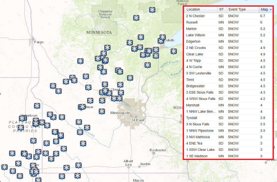
Snowfall Reports
Here's look at some of the snowfall reports from Sunday into Monday across the region. The highest tally I could find was from near Chester, SD with nearly 7" of snow, while the greatest amount out of Minnesota was located in Russell at 6".
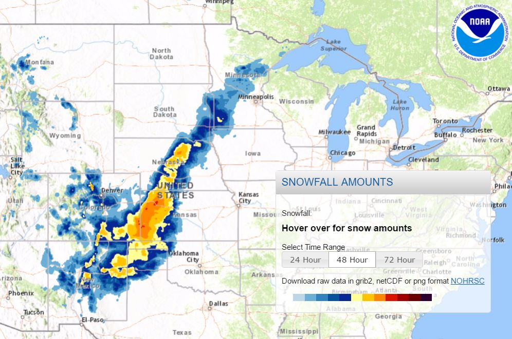
Snowfall Analysis
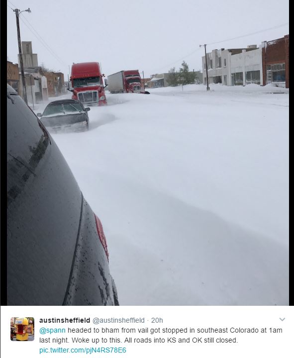
Here's the snowfall analysis since the weekend and snow the heavy snow amounts in far Western Kansas as well as parts of far western Oklahoma and Texas. These are areas that had blizzard conditions as well as places into southeastern Colorado and northeastern New Mexico.
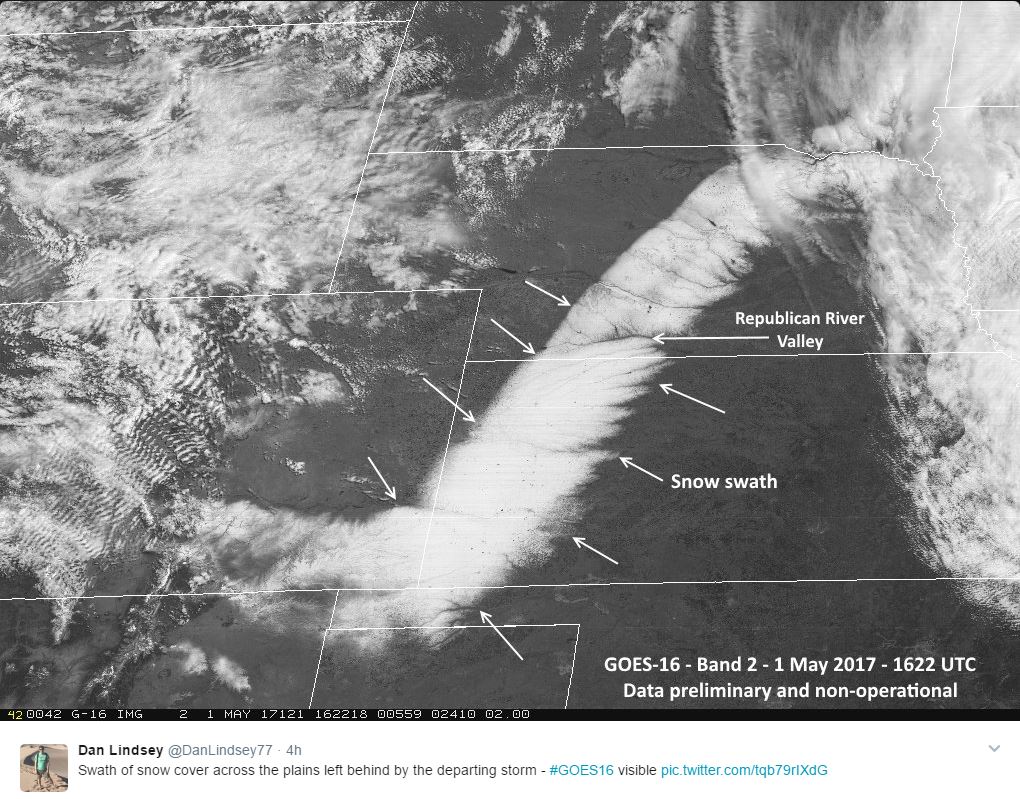
Snow Seen Via Visible Satellite
Here's a cool image from the new GOES 16 satellite, which shows heavy snow on the ground across the Plains and along the Front Range of the Rockies. Note how narrow this band was, especially across Kansas and Nebraska. The 2nd picture below shows how heavy the snow was across southeastern Colorado on Sunday!
___________________________________________________________________
Spits of rain through midweek. Brilliant weekend ahead!
By Todd Nelson, filling in for Douglas.
By Todd Nelson, filling in for Douglas.
Chances are you heard someone or even caught yourself complaining about yesterday's weather. Hey, I am even guilty! I don't blame you for being sour about weather conditions as we rang in the first day of May. It's a tricky time of year. Your wardrobe is in flux, heavy coats one day and flip flops a few days later. Welcome to spring in Minnesota!
After a very foul Monday and some even waking up to slushy snow accumulations, weather conditions will slowly improve this week. Keep in mind that our average high in the Twin Cities is 65 degrees, but lows can still dip into the teens and 20s across the state.
We're getting close to being able to goof around in the garden. Cold weather crops are ok, but it is likely still a little early for mater plants.
The good news is that I don't see any major cool downs coming through mid-month. In fact, temperatures return to near average levels later this week after a few showers midweek. The weekend looks to bring a string of sunny days with highs in the 60s. Better book that tee-time now!
_______________________________________________________
_______________________________________________________
Extended Forecast
TUESDAY: Gradual clearing. Feeling warmer. Winds: NW 5-10. High: 57.
TUESDAY NIGHT: Partly cloudy and quiet. Winds: NNW 5. Low: 42.
WEDNESDAY: Back to near average temps. A few PM rumbles possible. Winds: SSW 5-10. High: 64.
THURSDAY: Lingering afternoon shower? Winds: NW 5-10. Wake-up: 44. High: 63.
FRIDAY: Few clouds. A fine Friday ahead! Winds: WNW 5-10. Wake-up: 42. High: 62.
SATURDAY: Mostly sunny. Bring it on! Winds: N 10-20. Wake-up: 45. High: 65.
SUNDAY: Dry. Spring cleaning. Winds: W 5. Wake-up: 42. High: 63.
MONDAY: A string of sunny days continues. Winds: ENE 5-10: Wake-up: 43. High: 65
_______________________________________________________
_______________________________________________________
This Day in Weather History
May 2nd
May 2nd
2013: A historic snowstorm dumps up to 18 inches of snow in southeast Minnesota and west central Wisconsin. Blooming Prairie receives 18 inches from this storm, and Eau Claire gets 9.3 inches.
________________________________________________________
________________________________________________________
Average High/Low for Minneapolis
May 2nd
May 2nd
Average High: 65F (Record: 91F set in 1959)
Average Low: 44F (Record: 24F set in 1961)
Average Low: 44F (Record: 24F set in 1961)
Record Snowfall: 2.2" set in 1954
__________________________________________________________
__________________________________________________________
Sunrise/Sunset Times for Minneapolis
May 1st
May 1st
Sunrise: 6:01am
Sunset: 8:20pm
Sunset: 8:20pm
Daylight gained since yesterday: ~2mins & 41secs
Daylight gained since winter solstice (December 21st): ~5hours & 34mins
__________________________________________________________
Daylight gained since winter solstice (December 21st): ~5hours & 34mins
__________________________________________________________
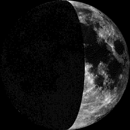
Moon Phase for April 30th at Midnight
0.8 Days Before First Quarter
0.8 Days Before First Quarter
_____________________________________________________________
Weather Outlook For Tuesday
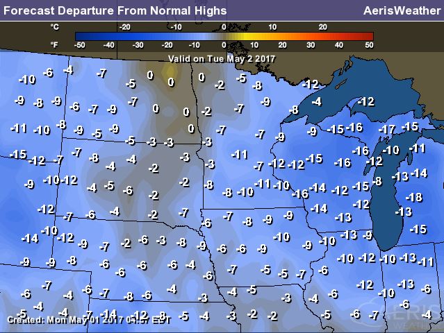
While high temperatures will still be a bit on the cool side Tuesday, we'll at least be headed in the right direction. Most locations across the state will warm back into the 50s, which will still be nearly 10F below average.
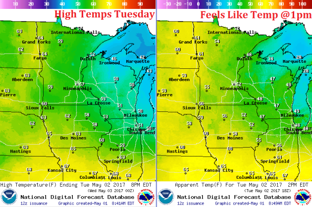
Weather Outlook for Tuesday
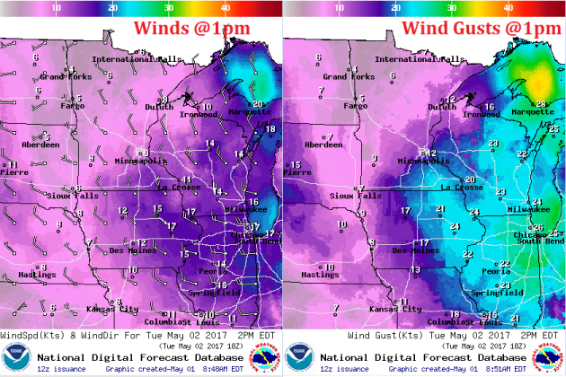
Winds won't be quite as bad as they were on Monday, but a few locations across southeastern Minnesota could still have to contend with a few gusts up to near 20mph through the afternoon.
Weather Outlook for Tuesday
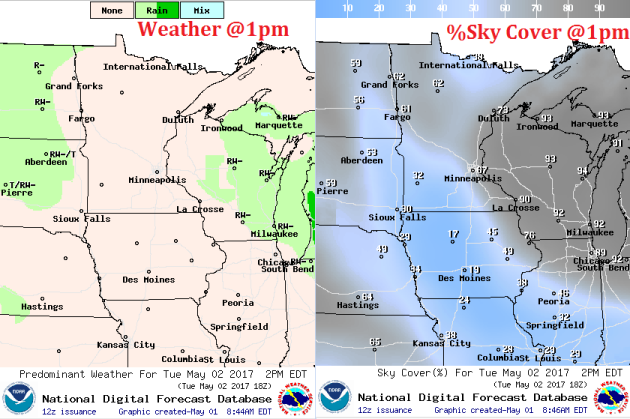
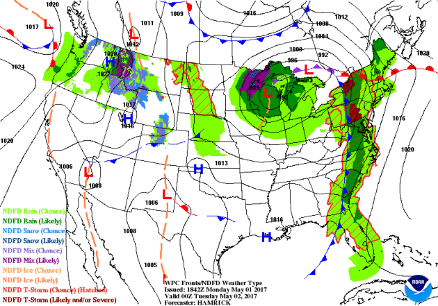
Clouds will slowly fade across the state as the storm system moves east. Slate-gray skies and spits of rain will lingering across the Mississippi River Valley and into Wisconsin, while folks across the state may see a little sunshine through the day. Note our next batch of precipitation moving in from the Dakotas, this will be with us on Wednesday.
Precipitation Outlook for Minnesota
Total precipitation amounts across the region look pretty impressive with several spots seeing nearly 1" or more from Sunday into Monday. Kudos if you got your yard work done and spread some fertilizer this weekend. This will be a good soaking, so your lawn should green up quickly!
___________________________________________________________________________
Soggy Storm System
Here's the weather outlook through Wednesday night, which shows the storm system that brought rain/snow showers to the region on Sunday and Monday, moving east through the Great Lakes. Tuesday will be a little better across the Upper Midwest, but there will be a few showers and isolated thunderstorms that drift through on Wednesday.
.gif)
_________________________________________________________________
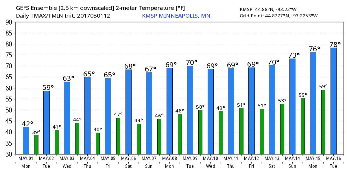
Temperature Outlook
Here's the temperature outlook through the middle part of May. The good news is that temperatures look to warm to near average levels (mid 60s) again by the end of the week with highs warming to near 70 by the first weekend of May! The upcoming weekend looks to make up for the rotten start to May. Let's hope that the forecast holds, it could be a beauty!
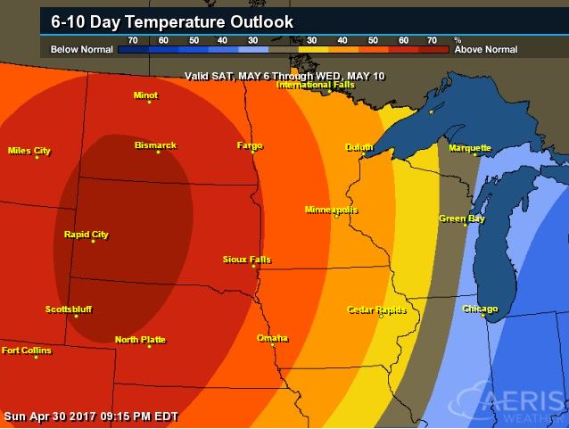
8 to 14 Day Temperature Outlook
According to NOAA's CPC, the extended temperature outlook suggests warmer than average temperatures moving back into the Upper Midwest through the first week/weekend of May. Highs will once again warm into the 70s as we approach the weekend!
___________________________________________________________
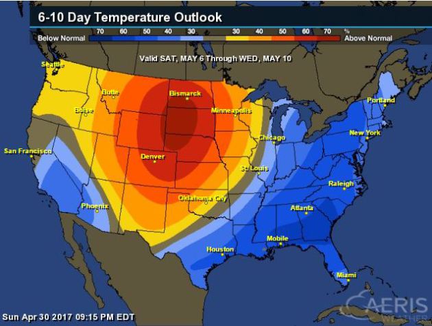
Extended Temperature Outlook
According to NOAA's CPC, the extended temperature outlook shows much cooler than average weather settling in across the Eastern and southern part of the country as we approach the first weekend of May. However, warmer than average temperatures will settle in across the Plains, Midwest and the Southwestern US.
Temperature Trend
Here's the temperature trend through the weekend and early next week. Note cooler than average temperatures look to linger across the eastern half of the country. Some of the coolest weather will be found across parts of the Northeast as we head into the 2nd week of May, while warmer than average temperatures look to move in across the western part of the country and eventually into parts of the Central US.
Weather Outlook This Week
A large storm system will wrap over the Great Lakes and the East Coast by Tuesday, while another batch of showers and storms moves into the Central US by midweek. This next storm system will bring another round of heavy rain and a few isolated strong to severe storms across the Deep South.
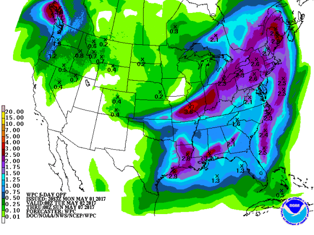
5 Day Precipitation Outlook
According to NOAA's WPC, the 5 day precipitation outlook continues to show fairly decent rainfall tallies across parts of the Eastern US with some locations seeing nearly 2" to 3" or more.
____________________________________________________________________
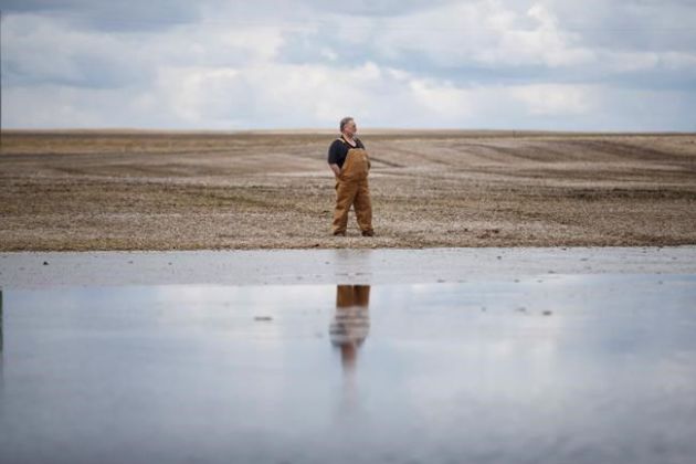
"Unharvested crops, wet spring causing headaches for Candian Prairie farmers"
"When Humphrey Banack looks out the window on his farm, he can't see some of the fields he depends on to put food on the table and pay his bills. Water from rain and melting snow is soaking grain and oilseed crops that the farmer near Round Hill, Alta., couldn't harvest last fall due to bad weather. And fields he did manage to harvest are too sodden to walk on, let alone seed, due to a cold and wet spring. "I haven't seen this much water lying around in all of the years I have farmed," Banack said. "We are looking at another two to three weeks before we can plant any crops or deal with the old crops." Removing and disposing of last year's unharvested grains will be a challenge across much of the Prairies for many farmers who are eager to start spring seeding. Alberta's Agriculture Financial Services Corp. says there are about 400,000 hectares of insured unharvested crops left over from last fall. A similar amount of uninsured crops remain in fields."
(Image Credit: KelownaDailyCourier)
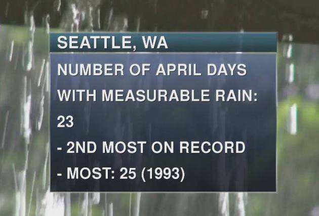
Wet In The Pacific Northwest
How about Seattle, WA! They officially had 23 days of measurable rain during the month of April, which is the 2nd most on record. The record of 25 set in 1993 still stands, but no question, April 2017 was a gloomy month for folks in the Pacific Northwest.
____________________________________________________________
"Cities brace for climate challenges"
"Faced with exploding populations and steadily rising temperatures worldwide, cities must make haste in reinforcing defences against climate change-induced flooding and heat waves, experts warned this week.City temperatures are forecast to shoot up in the coming years, exposing inhabitants to killer heat spikes, while rising sea levels and river flooding threaten homes, drinking water, and transport and electricity infrastructure. Cities are vulnerable to a unique risk called the "urban heat island" (UHI) effect—their concrete surfaces retain more of the sun's heat than undeveloped areas, scientists explained at a meeting of the European Geosciences Union (EGU) in Vienna. By midcentury, if planet-warming fossil fuel emissions continue unabated, city temperatures in Belgium could exceed today's heat-alert levels by as much as 10 degrees Celsius (18 degrees Fahrenheit) for 25 days each summer, according to one research paper. Another study showed that heat waves will become a frequent challenge for European cities—more numerous in the south of the continent, more intense in the north."
(Scientists say flooding is a growing risk for cities, with Paris due for its next one-in-a-hundred-years flood)

___________________________________________________________________________
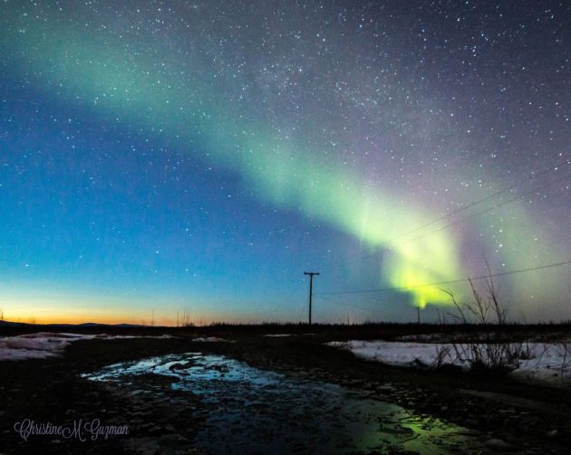
"Goodnight to the lights"
And just like that, the lights were gone. As we climb toward summer, gaining ample light each day, the aurora is seemingly showing less and less. We know that’s not true — it’s there, even on summer solstice, but our chances of seeing it won’t return until at least September or maybe August, if we’re lucky. A few nights earlier this month offered an excellent last chance to view the aurora, and we’re sharing some of those photos here, which have been shared by you, the reader, with us at the News-Miner. Enjoy these shots of one of the many things that make Interior Alaska great. Dear northern lights, we’more from see you in autumn.
(Photo credit: Christine Guzman via NewsMiner.com)
"The Year That Broke Portland’s Rain Counter"
For years, I’ve had a Portland rainy day counter. Right on bottom of this page. But this rainy season of 2016-2017 the counter broke. Or more specifically, the rainy season broke me – since I have to manually update the rainy day counter! So much rain, so little time. Here it is, then, in one lump some payment: 149 rainy days as of Saturday evening April 29, 2017. This is the most rainy days Portland has had in a single rainy season, which runs from October 1 – May 31 each year. And we have a lot of time left to add to this total. And if you look at October to April this has been Portland’s 2nd wettest in history. We’re closing in on 46″ when we should be at 29″ since October 1. That’s about 160% of average.
___________________________________________________________________
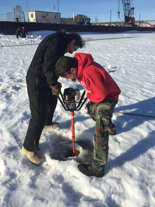
"Alaska Guessing Game Provides Climate Change Record"
"Buy a ticket in the Nenana Ice Classic and you could win nearly $300,000. All you have to do is guess when the ice covering Tanana River at the city of Nenana, Alaska will break up. Brothers Josh and Judah Ridgeway live in Nenana, a community of 375 people, about an hour southwest of Fairbanks. The brothers were hired by the Ice Classic to make regular ice measurements. They use a gas powered drill to bore through 3 to 4 feet of ice — though it's sometimes more. They do this at several locations on the Tanana, a few times a week, in April."
(Judah (left) and Josh Ridgeway drill a hole in the Tanana River at Nenana, Alaska to measure the thickness of the ice on April 13th. Dan Bross/KUAC)
"EPA removes climate change information from website"
The EPA removed most climate change information from its website Friday, saying in a press release that language on the website is being updated to "reflect the approach of new leadership." EPA Administrator Scott Pruitt has expressed doubt about the reasons for climate change, saying in a CNBC interview in March that he was skeptical of the role carbon dioxide plays. "I think that measuring with precision human activity on the climate is something very challenging to do, and there's tremendous disagreement about the degree of impact," Pruitt said. "So, no, I would not agree that it's a primary contributor to the global warming that we see."

"100 Percent Renewable Energy by 2050: Senators Introduce 'Most Ambitious' Climate Plan Ever"
Bill from Sanders, Merkley, and Markey reflects growing public demand to shift away from fossil fuels and usher in era of climate justice. Sens. Bernie Sanders (I-Vt.), Jeff Merkley (D-Ore.), and Edward J. Markey (D-Mass.) on Thursday introduced legislation to build a 100 percent renewable energy economy by 2050—a bill that environmental group 350.org previously termed "the most ambitious piece of climate legislation Congress has ever seen," although others caution that it is not enough to meet the real challenges of climate change. The "100 by 50" Act calls for 50 percent of U.S. electricity to be produced by renewable energy sources like wind or solar by 2030, and 100 percent by 2050. It would require zero carbon emission vehicle standards and prohibit federal approval of oil and gas pipelines, among other measures.

"Space-mining may be only a decade away"
Oil states are investing in companies and infrastructure that could one day mine minerals and water found on the moon and in asteroids. Is water the new oil of space? It may be to Middle Eastern oil states such as Saudi Arabia and the United Arab Emirates, who are looking at space as a way to diversify out of the earthly benefits of fossil fuel. “Middle East oil states are investing in satellite technology and trying to transform their domestic economies into digital economies and knowledge-based economies,” said Tom James of Navitas Resources, an energy consultant based in London and Singapore. As space colonizers such as Elon Musk and Jeffrey P. Bezos (owner of The Washington Post) aspire to shrink the cost of space travel, interest has picked up among oil states and others in how to power space settlements using water and minerals mined from the heavens. Oil states are investing in companies and infrastructure that could one day mine minerals and water found on the moon and in asteroids.

"Virgin Galactic Aims to Fly Space Tourists in 2018, CEO Says"
CAPE CANAVERAL, Fla. — Richard Branson's Virgin Galactic is on track to begin commercial passenger spaceflights before the end of next year, the company's chief executive said. For years, Branson has been optimistically forecasting the start of rides aboard SpaceShipTwo, an air-launched suborbital spaceplane that is designed to carry six passengers and two pilots to an altitude of about 62 miles (100 kilometers). During the suborbital hop, passengers will be able to experience a few minutes of microgravity and see the limb of Earth set against the blackness of space.
 _________________________________________________
Thanks for checking in and don't forget to follow me on Twitter @TNelsonWX

No comments:
Post a Comment