Butterfly Weed
I was out for a walk Monday morning and happened to notice this bright orange flower. WOW, was it vibrant. I took a picture so I could look it up... Turns out it's called Butterfly Weed! Here's an excerpt from GardeningKnowHow.com: "Butterfly weed plants (Asclepias tuberosa) are trouble-free North American natives that produce umbels of bright orange, yellow or red blooms all summer long. Butterfly weed is appropriately named, as the nectar- and pollen-rich flowers attract hummingbirds and hordes of butterflies, bees and other beneficial insects throughout the blooming season."

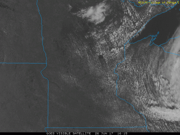
Visible Satellite on Monday
Fair weather cumulus clouds popped up on Monday, some of which gave way to scattered thundery downpours across the Arrowhead and Northwestern Wisconsin. Convective clouds are pretty neat to look at from space!
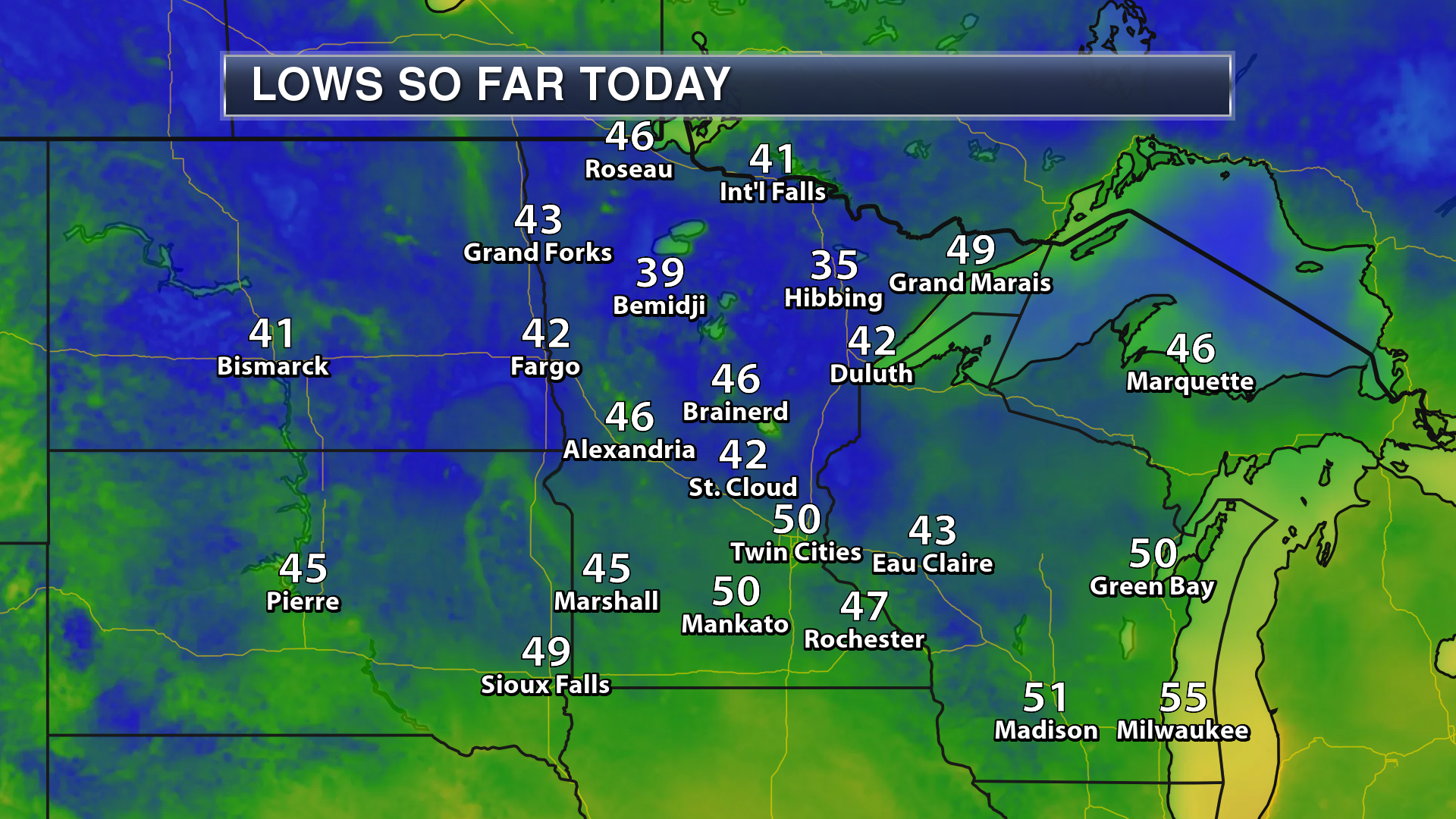
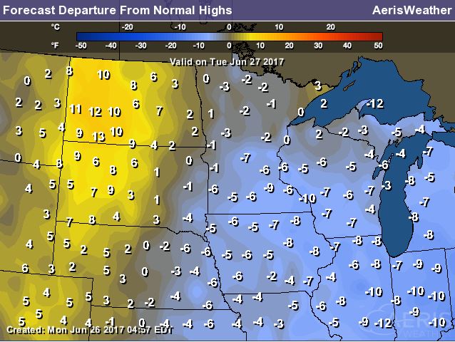
Chilly Monday Morning in Minnesota
BRR... these were the low temperatures from Monday morning. Sure it's late June, but some locations dipped down into the 30s, more reminiscent of Fall. In fact, Embarrass dropped down to 33F!
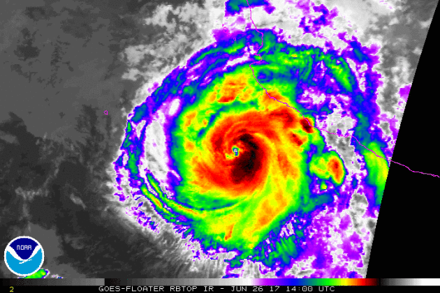
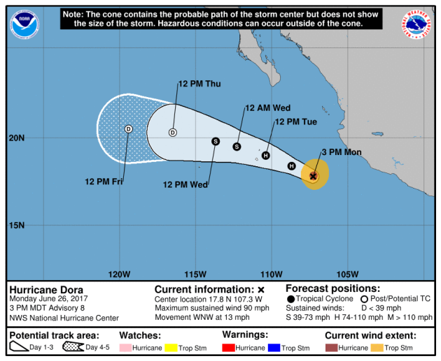
DORA: First Hurricane in the Eastern Pacific This Season
Here's a look at the first hurricane of the 2017 Eastern Pacific Hurricane Season. Note that Dora had a pretty defined eye with sustained winds of 90mph as of late Monday afternoon.
Tracking DORA
According to NOAA's NHC, Dora will continue on a westward track away from mainland Mexico through the last few days of June before diminishing into a tropical depression by the end of the week.
______________________________________________________________________
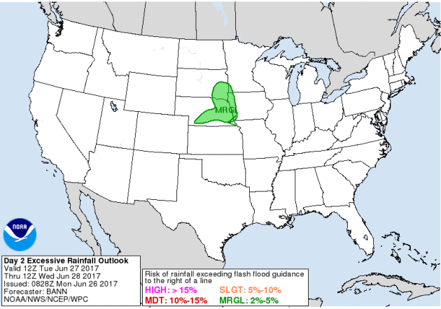
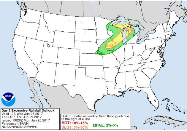
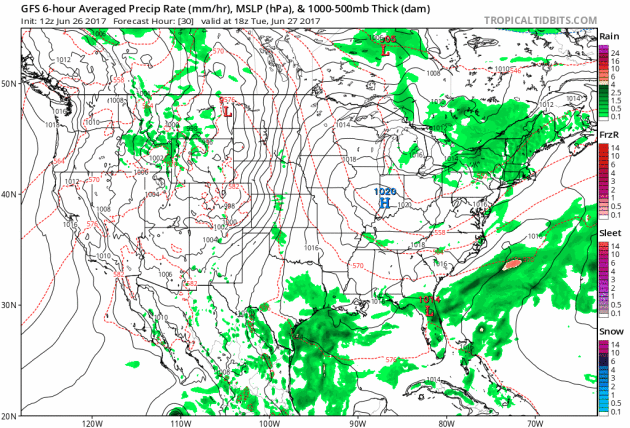
Flood Concerns Tuesday & Wednesday
According to NOAA, excessive rainfall will be possible across parts of the Central US and into the Great Lakes Region through midweek. Some of the thunderstorms could be responsible for localized areas of flooding and isolated severe weather.
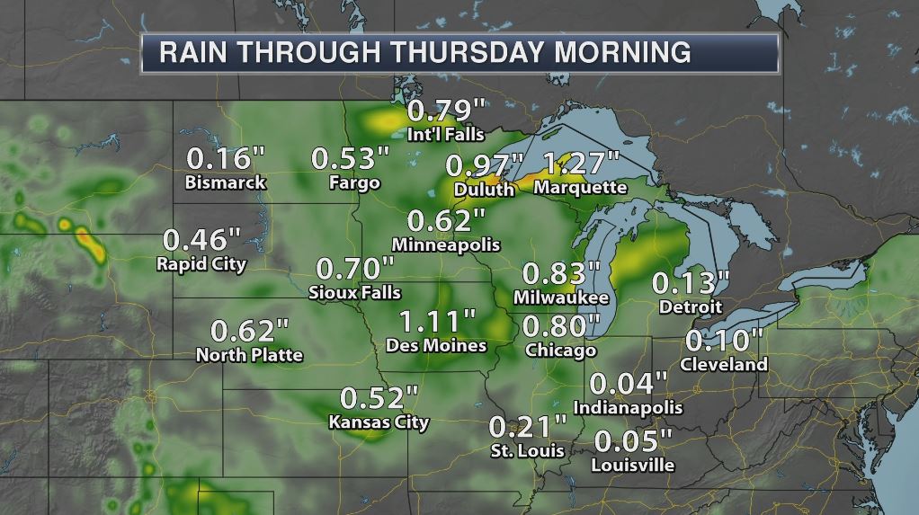
Take a look at the heavy rain potential across the Upper Midwest through Thursday morning. Note that some locations could see 1" or more.
________________________________________________________
Weather Outlook
A storm system moving into the Central US will be responsible for soaking rains late Tuesday into Wednesday with some 1"+ rainfall tallies. By Thursday and Friday, lingering strong to severe storms will be possible across the Central US.
_________________________________________________________________
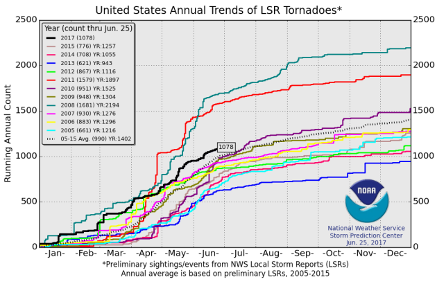
PRELIMINARY 2017 Tornado Count
According to NOAA's SPC, the PRELIMINARY 2017 tornado count is 1078 (through June 25). Note that is the most active year for tornadoes since 2011, when there were nearly 1,500 tornadoes. Keep in mind there was a major tornado outbreak in the Gulf Coast region from April 25-28, 2011 that spawned nearly 500 tornadoes, some of which were deadly. That outbreak is known as the Super Outbreak of 2011 and has gone down in history as one of the biggest, costliest and one of the deadliest tornado outbreaks in history.
_________________________________________________________________
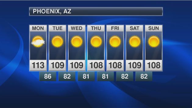
Extended Forecast for Phoenix, AZ
Here's the extended forecast for Phoenix, AZ, which calls for very hot temperature still, but it won't be quite as hot as it was last week with readings close to 120F. Note that the normal high for late June is around 106F... YIKES!
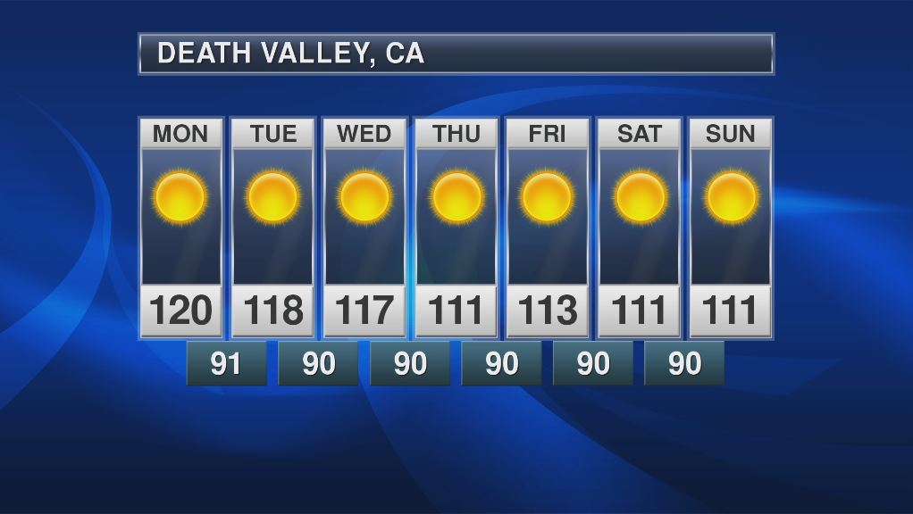
Death Valley, CA
Summer is the Desert is quite hot. Take a look at the forecast for Death Valley, CA where readings will still be in the 110s, but not quite as hot as they were last week. Last week, temperatures soared to near 125F!!! Unreal.
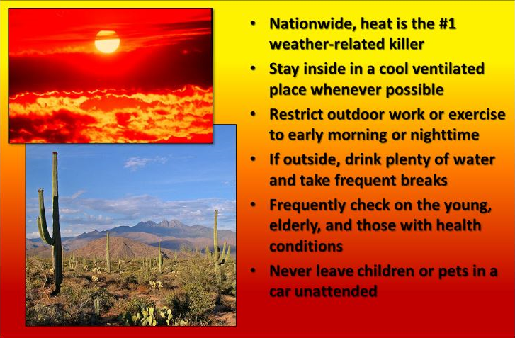
Heat is the #1 Weather Related Killer in the U.S.
"Nationwide, heat is the #1 weather-related killer. Stay inside in a cool ventilated place whenever possible. Restrict outdoor work or exercise to early morning or nighttime. If outside, drink plenty of water and take frequent breaks. Frequently check on the young, elderly, and those with health conditions. Never leave children or pets in a car unattended."
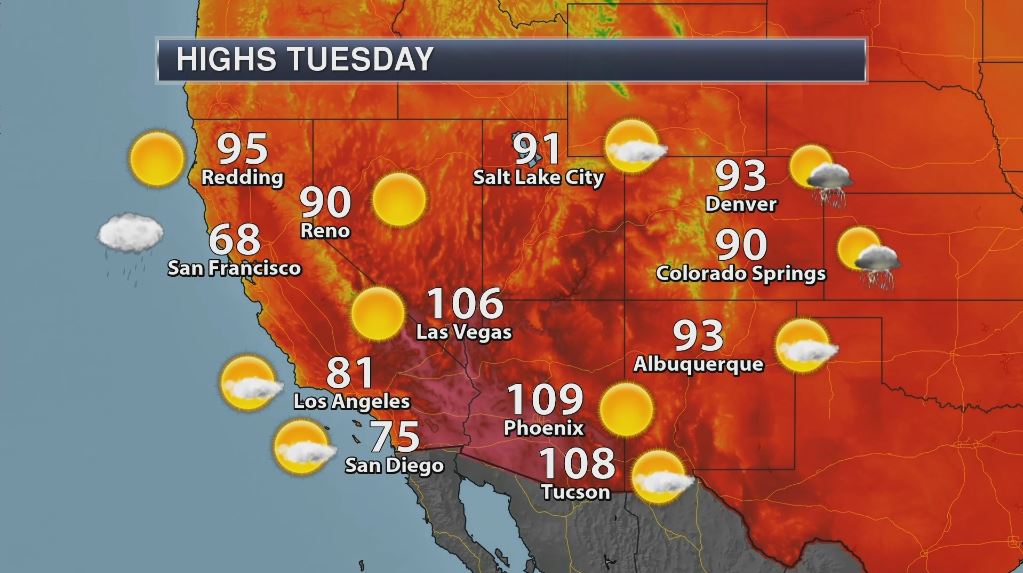
Tuesday: High Temperatures & Highs Above Average
High temperatures on Tuesday across the Southwest will still be very warm with desert locales in the triple digits. The good news is that the worst of the heat looks to be fading for now as temperatures look to settle closer to normal values through the rest of the week.
_______________________________________________________________________
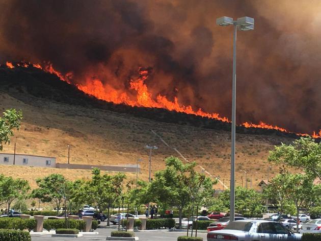
"Blistering Southwest heat wave easing, but winds fan wildfires"
"The end was finally in sight Sunday for the heat wave blasting the Southwest for more than a week, but that might not help firefighters battling about 20 major blazes across the region. AccuWeather senior meteorologist Kristina Pydynowski said the high pressure system that has locked in the heat will begin to loosen midweek. "It's a double-edged sword," she told USA TODAY. "We will see winds pick up in the afternoons. That could prove problematic for firefighters." California doesn't need more problems fighting fires. More than 19,000 acres have burned so far this year — more than double what had burned at this time in 2016, the state's most recent survey from a week ago shows, said Scott McLean, deputy chief with the California Department of Forestry and Fire Protection. McLean said heavy winter rains that took the edge off the state's severe drought also enhanced the growth of grasses and brush. Grass that dried out in the heat is burning, and the fires can be whipped by the winds. "The combination of heat and wind is exactly what firefighters don't want to see," McLean said."
(Men jog along the consolidated canal at sunset, Thursday, June 22, 2017 in Chandler, AZ Photo: Matt York AP via USAToday)

"870-Acre Wildfire in Santa Clarita Now 50 Percent Contained"
"A brush fire in Santa Clarita climbed over hillsides near the 14 Freeway north of Los Angeles and spread to about 870 acres Sunday afternoon, forcing freeway closures and evacuations. Firefighters responded to the blaze at northbound Highway 14 at Placerita Canyon around 12:45 p.m. A traffic crash caused a tree to catch fire and flames spread rapidly across the canyon area, according to the Los Angeles County Sheriff's Department. The half-acre fire quickly grew and had burned 870 acres by 11 p.m., said the Los Angeles County Fire Department. Aerial video showed blackened hillsides and canyon areas as the fire marched through brush. The fire, dubbed the Placerita Fire, destroyed a structure in Disney Ranch and damaged a bridge and another structure, the department said. One firefighter suffered minor injuries."
________________________________________________________
Ongoing Large Wildfires
Here's a look at the current wildfires across the Western US. The recent hot weather has allowed tinder dry conditions to develop, which has led to several wildfires popping up. Note that many are currently burning in southern California, Arizona and in New Mexico.

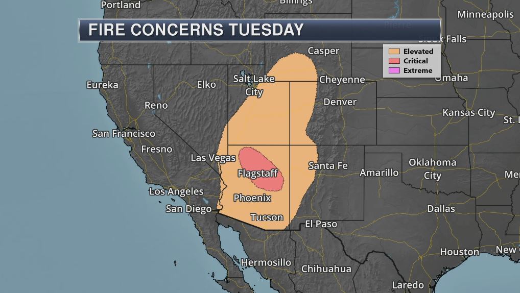
Fire Weather Concerns
Fire weather concerns will still be quite high across parts of the Southwest. Note that some spots in northern AZ will be at critical fire weather concerns, while elevated fire weather concerns will still be found as far north as Wyoming.
________________________________________________________________________
Soaking Rains Arrive Overnight. Sweaty by the 4th
By Todd Nelson, filling in for Douglas
By Todd Nelson, filling in for Douglas
I recently got back from a fun trip up at the cabin. A weekend filled with cake, presents and lots of contagious laughs with my lovely Grandmother. However, I sure got an earful from my 5 and soon-to-be 8 year old sons regarding the weather. They still think that because I am a meteorologist, I can make it sunny and warm. Well, despite catching lots of fish, it was still my fault that the weather wasn't warm enough to swim. Sorry boys...
I get it! When it's summer, Minnesotans don't want to be cheated out of it. Our 66 degree high temperature on Saturday was the coldest June high we've seen since the 66 degree high on June 14, 2016. No more of that please.
We'll keep the free A/C going through the rest of the week, but soaking rains arrive Tuesday night and Wednesday. Some lawns and gardens could get a healthy drink as models are suggesting nearly 1 inch of rain in a few spots. A few sputtery rain showers will be possible on Friday and Saturday, but it won't be a washout.
Hot and sweaty weather looks to return by July 4th.
______________________________________________________
______________________________________________________
Extended Forecast
TUESDAY: Breezy. Filtered sunshine. Winds: S 10-20 High: 77
TUESDAY NIGHT: Storms likely overnight. Winds: SSE 5-10. Low: 62.
WEDNESDAY: Scattered storms. Plenty of puddles. Winds: SS 10-15. High: 77
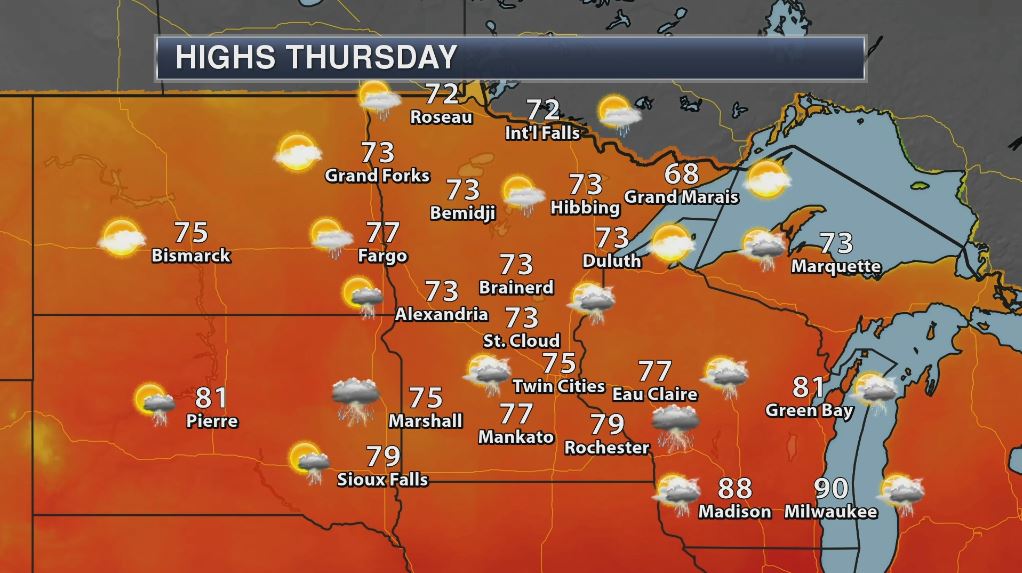
THURSDAY: Stubborn clouds. Peeks of PM sun. Winds: NNW 5-10. Wake-up: 63. High: 76
FRIDAY: Unsettled, showers and T-storms. Winds: ESE 5-10. Wake-up: 60. High: 73
SATURDAY: Sunny start, few PM T-storms. Winds: E 5. Wake-up: 58. High: 74
SUNDAY: Warmer. Pop up shower? Winds: SE 5. Wake-up: 59. High: 78.
MONDAY: July 4th Eve. Nice summer day! Winds: SE 5. Wake-up: 62. High: 80.
_______________________________________________________
_______________________________________________________
This Day in Weather History
June 27th
June 27th
1908: A tornado hits Clinton in Big Stone County.
________________________________________________________
________________________________________________________
Average High/Low for Minneapolis
June 27th
June 27th
Average High: 88F (Record: 104F set in 1934)
Average Low: 62F (Record: 44F set in 1925)
Average Low: 62F (Record: 44F set in 1925)
Record Rainfall: 2.00" set in 1953
_________________________________________________________
_________________________________________________________
Sunrise/Sunset Times for Minneapolis
June 27th
June 27th
Sunrise: 5:29am
Sunset: 9:03pm
Sunset: 9:03pm
Hours of Daylight: 15hours & 35mins
Daylight LOST since yesterday: ~26 seconds
Daylight LOST since summer solstice (June 20th): ~1 minute
__________________________________________________________
Daylight LOST since summer solstice (June 20th): ~1 minute
__________________________________________________________
Moon Phase for June 26th at Midnight
3.2 Days Since New Moon
3.2 Days Since New Moon
__________________________________________________________________________
Weather Outlook for Tuesday
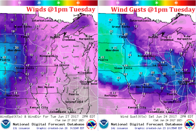
Winds will begin to pick up across the region on Tuesday as a storm system approaches from the West. Here's the wind depiction midday Tuesday, which suggests gusts approaching 20mph+ across western and southern MN.
Weather Outlook for Tuesday
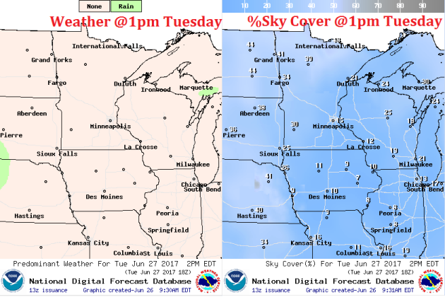
Tuesday looks like another pleasant day with only high clouds filtering out the sunshine through the day. Soaking rains won't move in until Tuesday night/Wednesday.
__________________________________________________________________________
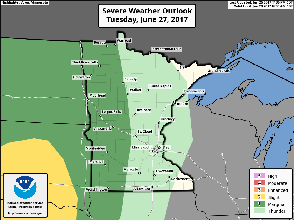
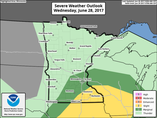
Strong Storms Possible Tuesday & Wednesday
Here's the severe threat for Tuesday and Wednesday, which shows the best potential of strong to severe storms moving into far western MN late Tuesday and then redeveloping across far southeastern MN on Wednesday as the storm system moves through the region.
Storms Push Through Southern MN Today
Here's the weather outlook through from Tuesday to Thursday, which shows widely scattered showers and storms across the Upper Midwest late Tuesday into Wednesday. Isolated strong to severe storms will be possible along with locally heavy rainfall.
.gif)
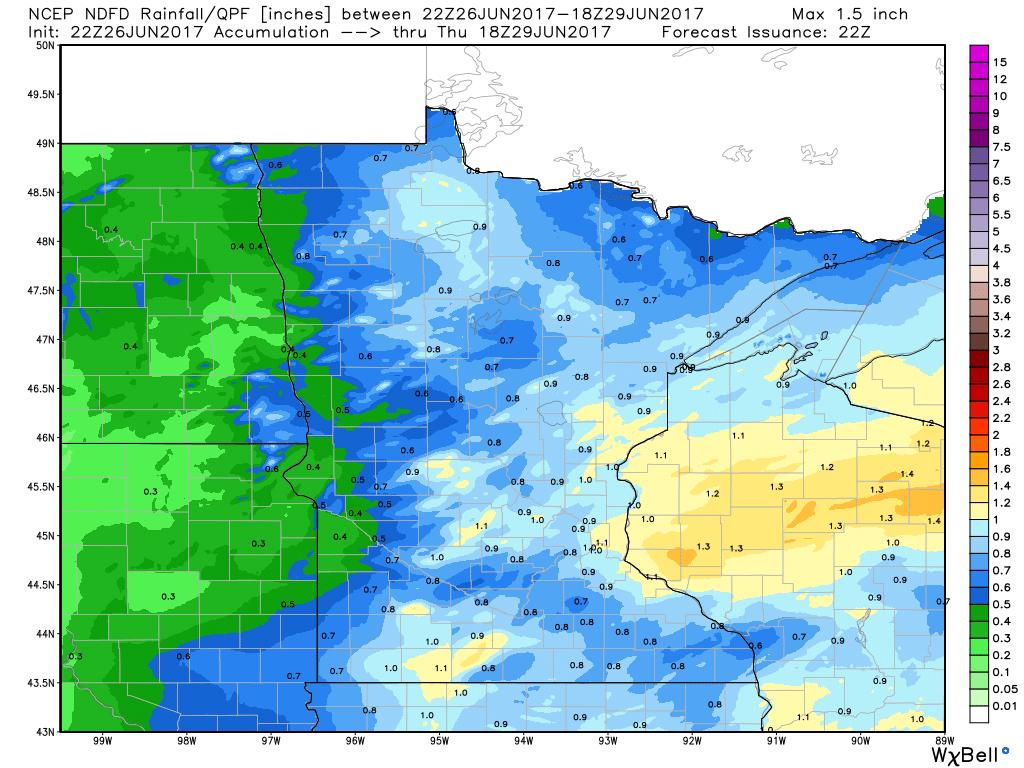
Extended Rainfall Forecast
Here's the rainfall potential through midday Thursday, which shows widespread heavy pockets of rainfall as out next storms system move through.
Weather Outlook For Tuesday
High temperatures on Tuesday will still be below average for this time of the year, but it'll be very comfortable for late June with highs in the 70s and low humidity.
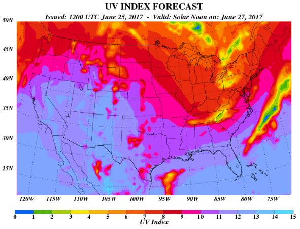
UV Index for Tuesday - VERY HIGH
The UV Index will be considered VERY HIGH across much of the state of Minnesota on Tuesday, which means that it will only 15 to 20 minutes or less to burn unprotected skin. With that said, if you are planning on spending any extended length of time outside, make sure you wear appropriate attire and lather on the sun block!
"Overlooking This Tiny Detail on a Sunscreen Bottle Causes Major Skin Burns"
"It's 2017, and by now, we're well aware of the risks of tanning. We know to apply sunscreen every two hours, we know to put it on for all outdoor activities, and we know how important it is to apply even when it's cloudy. But what about expired sunscreen? What happens if we're following all the sun protection rules, but still manage to get a horrible sunburn because of an old bottle of sunscreen? I fell victim to a sunscreen expiration date, and now, it's the first thing I check before applying SPF."

_____________________________________________________________
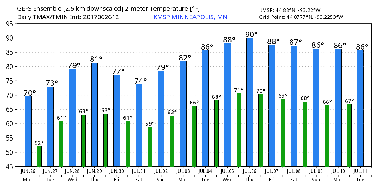
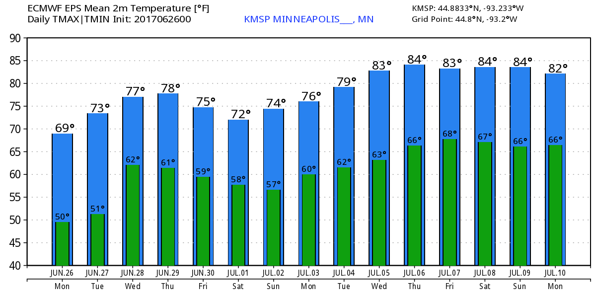
Temperature Outlook
Here's the temperature outlook from 2 different models through into the early part of July. After lingering cool temperatures, it appears that hot and sticky weather returns into early July. Highs could consistently be in the upper 80s to lower 90s through the 2nd week of July.
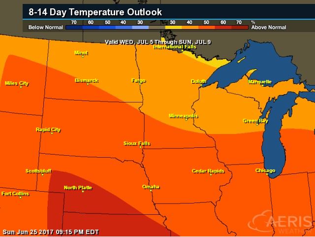
8 to 14 Day Temperature Outlook
According to NOAA's CPC, the extended temperature outlook through July 9th suggests warmer than average temperatures moving back into the Upper Midwest. After several days of cooler weather, we'll finally get back to warmer than average weather.
___________________________________________________________
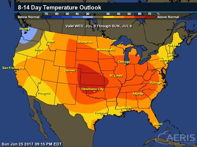
Extended Temperature Outlook
According to NOAA's CPC, the extended temperature outlook through July 9th suggests much warmer than average returning to much of the nation. For the first time in a while, it appears that summery temps and humidity values will return across much of the nation.
 ____________________________________________________________
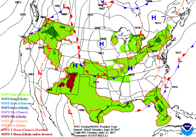
Weather Outlook This Week
The weather outlook over the next couple of days shows our next storm system moving through the Upper Midwest over the next several days. This storm maybe responsible for areas of locally heavy rainfall and isolated severe storms through the end of the week.
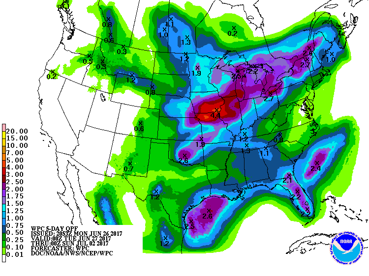
5 Day Precipitation Outlook
According to NOAA's WPC, the next several days could produce areas of locally heavy rainfall across the Central US. Note that widespread 2" to 4"+ can't be ruled out, which could lead to isolated flood concerns.
 ____________________________________________________________________
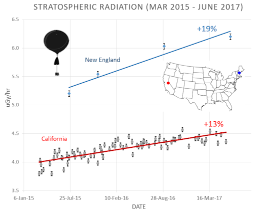
"NEW ATMOSPHERIC RADIATION RESULTS"
For the past two+ years, Spaceweather.com and the students of Earth to Sky Calculus have been monitoring cosmic rays in the atmosphere above California using high-altitude space weather balloons. After more than 100 flights, they find that dose rates have increased over the Golden State by 13% since March 2015. Now we know the same thing is happening over New England--only more so. The Earth to Sky team has flown balloons over Maine and New Hampshire four times since 2015, most recently on June 15, 2017. Although the data are relatively sparse compared to the better-sampled west coast, the results are clear. Radiation in the stratosphere over the northeastern corner of the USA is not only stronger than California, but also intensifying much faster--a 19% increase in New England vs. 13% in California.
______________________________________________
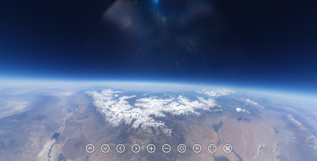
"SIERRA SNOWPACK AS SEEN FROM THE STRATOSPHERE"
A space weather balloon launched by Earth to Sky Calculus on June 23rd has captured remarkable spherical images of California's historic snowpack from the stratosphere. They show Sierra Nevada mountains laden with widespread snow despite an early summer heat wave that has sent temperatures shooting above 110 F at the base of the range. Click on the image to explore an interactive 360-degree scene. This is the same camera we will use to photograph the Moon's shadow from the stratosphere during the Great American Solar Eclipse on Aug. 21. 2017. Stay tuned for more information about our Solar Eclipse Balloon Network in the days ahead.
________________________________________________________
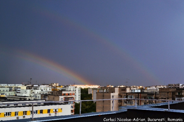
"'TWINNED RAINBOW' SPLITS DOWN THE MIDDLE"
"On 17th June, we had some very unsettled weather in Bucharest, Romania, with rain showers in the morning and a big storm in the afternoon," reports local resident Corlaci Nicolae-Adrian. "After the storm passed, a beautiful rainbow appeared, but it was strange..." The rainbow was split down the middle: Atmospheric optics expert Les Cowley, who invented the term 'twinned rainbow' about ten years ago, explains: "Sometimes, especially in stormy weather, a rainbow will split into two. It's rare and may last for only a few seconds. We think, but are not sure, that raindrops of different sizes make the twins. The upper bow is from nearly spherical smaller drops. Larger drops, more flattened by air resistance as they fall, make the lower bow. The two kinds of drops might be in separate rainsheets. Support for the 'two drop' proposal is that theory predicts that the outer secondary bow would not split – as in Nicolae-Adrian's picture." "Another idea, also consistent with an un-split secondary, is that one of the twins is from ice balls, a kind of upmarket hail. Though it's hard to see how they could ever be sufficiently smooth and transparent to make a rainbow. But there are always exceptions; this bow might just be from ice spheres."
(Image credit: Taken by Corlaci Nicolae-Adrian on June 17, 2017 @ Bucharest, Romania via SpaceWeather)
_________________________________________________
"Acting administrator of NASA talks Mars, climate change and SpaceX"
"The acting administrator of NASA says it's a "very exciting time" in the space industry, with his agency aiming to get a crew to Mars in the 2030s. Mars, it goes without saying, remains the next great goal in space exploration. Robert explained: "Right now we're working on trying to get there in the 2030s, with crew. We're building off what we're doing in the International Space Station - we're using that to do research on humans and the technologies we'll need to go further into space. "Hopefully in the decade of the 2020s we'll take those systems out in an area around the mean, so we can really test them out [...] before we embark onto the mission to Mars."The space industry in the US has grown surprisingly competitive in recent years. Commercial companies such as SpaceX, Blue Origin and Virgin Galactic are all building technologies to help humans travel beyond Earth. Robert very much welcomes these companies getting involved."

_____________________________________________________________
"Climate change in drones' sights with ambitious plan to remotely plant nearly 100,000 trees a day"
An Australian engineer is hoping to use drones to plant 1 billion trees every year to fight an unfolding global catastrophe. Key points: The drone system fires germinated seeds into soil Drones can plant in areas previously impossible to reach, like steep hills The technology could also help rehabilitate land once used by mines Deforestation and forest degradation make up 17 per cent of the world's carbon emissions — more than the entire world's transportation sector, according to the United Nations. Burned or cleared forests release their stored carbon dioxide into the atmosphere, and land restoration experts say technology must play a big part in addressing the problem. Dr Susan Graham has helped build a drone system that can scan the land, identify ideal places to grow trees, and then fire germinated seeds into the soil.

____________________________________________________________
Thanks for checking in and don't forget to follow me on Twitter @TNelsonWX

No comments:
Post a Comment