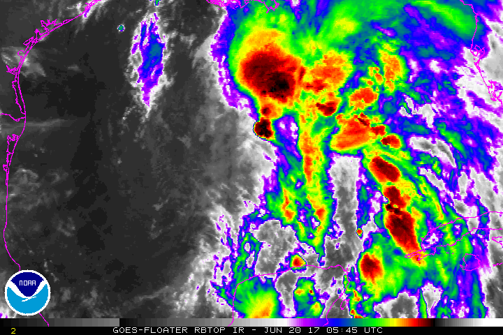
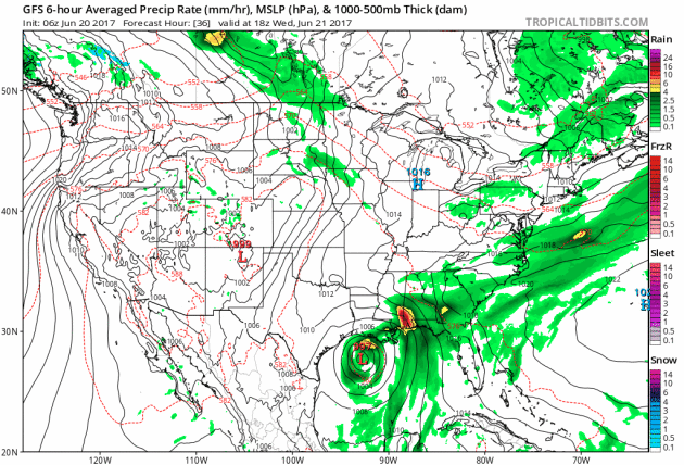
Tropical Storm Cindy in the Gulf of Mexico
We're not even a full month into the 2017 Atlanctic Hurricane season and we've already had 3 named storms develop in the basin. The National Hurricane Center is now keeping a close eye on a Tropical Storm Cindy in the Gulf of Mexico that is expected to bring gusty winds and heavy flooding rains to the Gulf Coast States. The slow movement of this storm could allow prolonged rain in some locations that could lead to significant rainfall over the next several days!
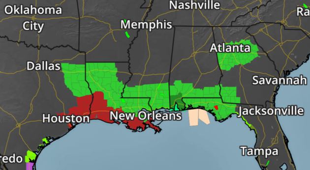
Tropical Storm Watches and Warnings
The National Weather Service has issued a number of Tropical Storm Watches and Warnings from Louisiana to Texas as tropical storm force winds and high seas impact the regioni. A number of Flash Flood Watches have also been issued from Louisiana to Florida and Georgia as potentially significant rainfall soaks the region over the next several days!
Tropical Trouble in the Gulf of Mexico
Take a look at the forecast for this system as it drifts west through the Gulf of Mexico and eventually north into Texas. While gusty winds and high season will likely impact the coastal communities closer to the center of the storm, one of the major concerns will be the heavy flooding rains on the eastern side of the storm. The conveyor belt of deep tropical moisture will impact much of the Gulf Coast States and into the Lower Mississippi Valley over the next several days.
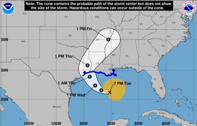
Tracking PT3C
According to NOAA's NHC, the track of this storm will likely make landfall somewhere along the Texas/Louisiana coastline late Wednesday night or early Thursday morning as Tropical Storm Cindy. Tropical Storm Force winds could create high seas and minor wind damage as it nears the coast, but heavy rainfall and flooding is still expected to be the major concern over the next few days.
Panama City Beach, FL
Take a look at the webcam from Panama City Beach, FL on Tuesday, where the system in the Gulf of Mexico was responsible for heavy rain and heavy surf. Conditions like this and potentially even worse can be expected for many coastal communities in the Gulf through the end of the week!

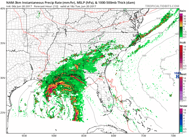
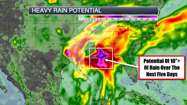
Heavy Rain Concerns
Flash Flood Watches have been posted by the National Weather Service across a wide area from Louisiana to Florida and Georgia. As deep tropical moisture soaks the region, widespread flooding can't be ruled out. Some of the latest forecast suggest that more than 10" of rain may be possible in spots through the weekend!
 ________________________________________________________
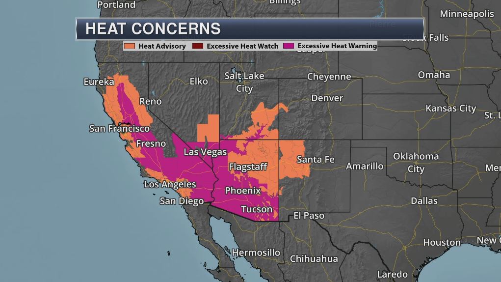
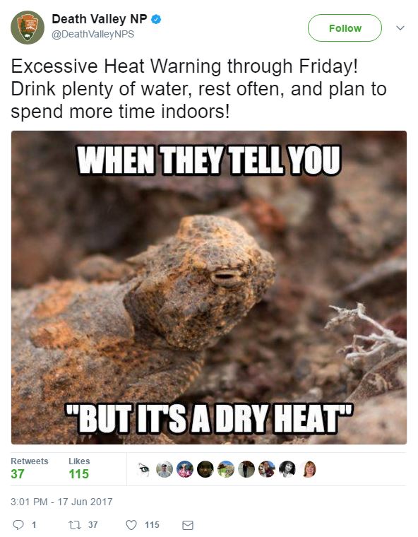
Extreme Heat Continues in the Southwest
The National Weather Service continues Excessive Heat Warnings and Advisories across a large part of the Southwest through midweek. In some cases, temperatures could be as hot as 120F+, especially for the desert locations including Death Valley, CA.
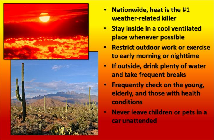
Heat is the #1 Weather Related Killer in the U.S.
"Nationwide, heat is the #1 weather-related killer. Stay inside in a cool ventilated place whenever possible. Restrict outdoor work or exercise to early morning or nighttime. If outside, drink plenty of water and take frequent breaks. Frequently check on the young, elderly, and those with health conditions. Never leave children or pets in a car unattended."
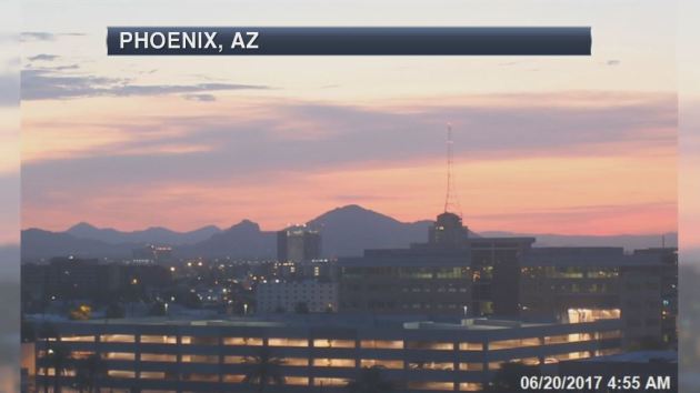
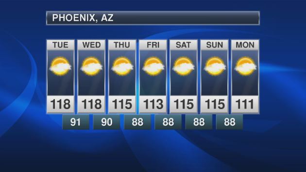
Extreme & Record Heat in Phoenix, AZ
On Monday, June 19th, Phoenix, AZ tied a record high temperature of 118F, which was also set last year 2016! Temperatures are expected to stay significantly hot over the next few days with readings around 110F by early next week!
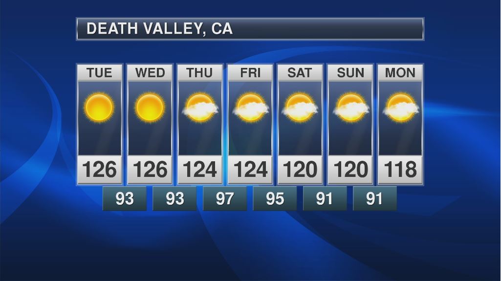
Death Valley, CA
Take a look at the forecast for Death Valley, CA, where readings could top 120F+ through the weekend before cooling a touch next week. Unreal...
"Tourists descend as temperatures climb in Death Valley"
"LAS VEGAS (AP) — Desert dwellers in the western U.S. see temperatures topping 120 degrees (49 Celsius) as a reason to hunker down indoors and turn up the air conditioning. But some tourists welcome it as a bucket-list opportunity to experience Death Valley — famously the hottest place in America. Many will get their chance in the days ahead as a vicious heatwave bakes parts of Arizona, California and Nevada. The mercury at Death Valley National Park reached 124 degrees (51 Celsius) on Sunday, and temperatures are expected to keep climbing through midweek as a dry, high-pressure system lingers over much of the Southwest. Many places saw triple-digit temperatures on Sunday, and the heatwave was blamed for power outages in several areas in California. "There's very few places on Earth to go to experience those temperatures, and Death Valley is one of those," said John Adair, a National Weather Service meteorologist."
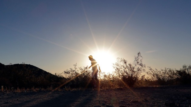
(FILE - In this June 16, 2017, file photo, a man runs through section of South Mountain Park at sunrise to avoid the excessive heat in Phoenix. (AP Photo/Matt York, File))
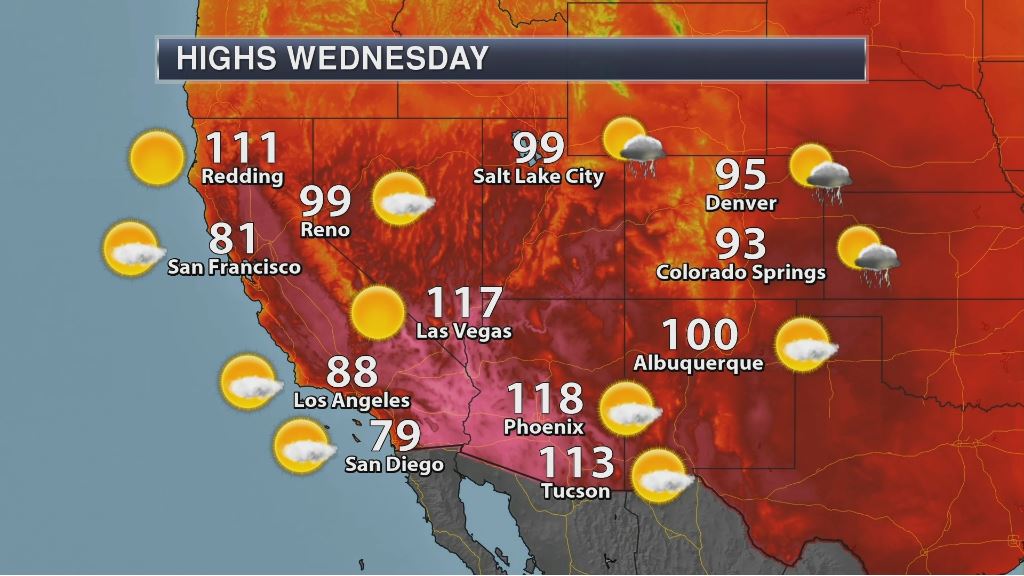
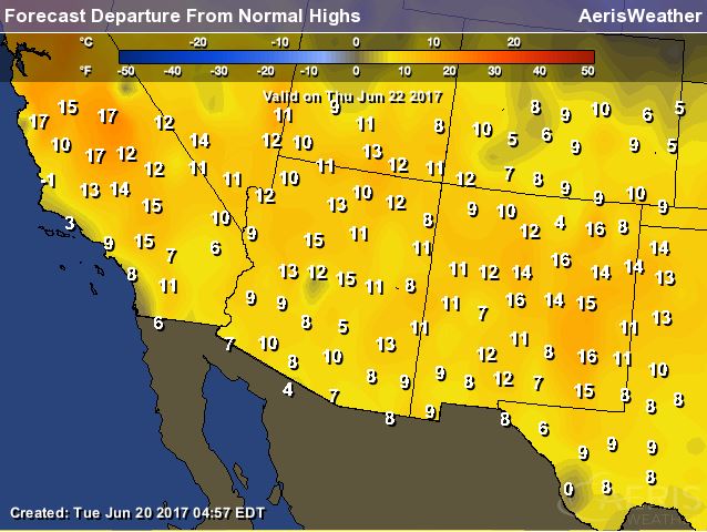
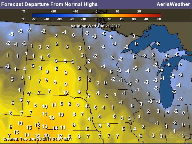
High Temperatures Wednesday
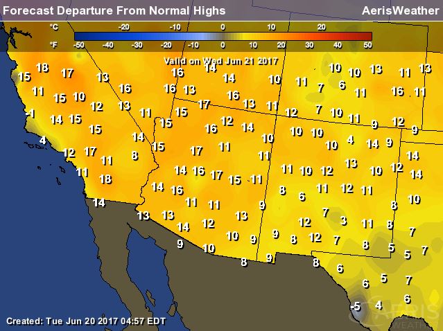
Here are the high temperatures expected in the Southwest on Wednesday. Note that many locations will likely be in the 90s & 100s once again. Note that temperatures will still be nearly 10F to 20F above average!
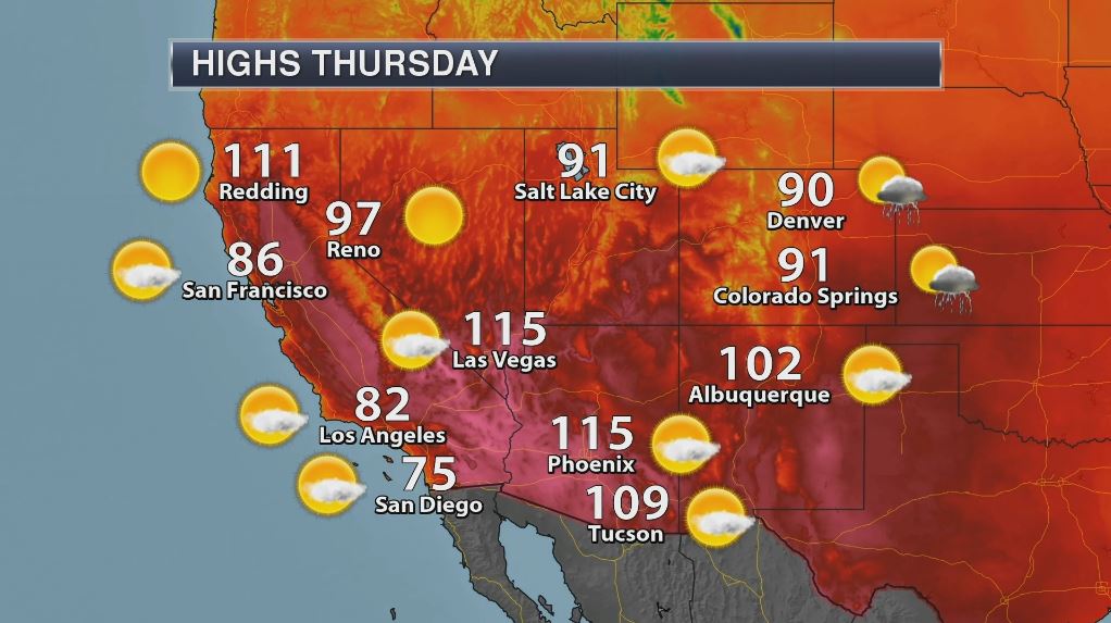
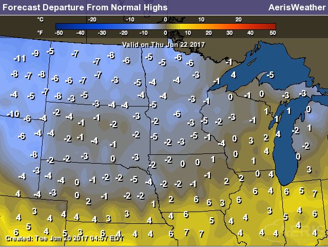
High Temperatures Thursday
It'll be another hot day in the Southwest on Thursday with temperatures still nearly 10F to 20F above average. With readings in the 90s & 100s once again, more daily record high temperatures could fall.
___________________________________________________
"When it comes to Southern California's heat wave, the worst is yet to come"
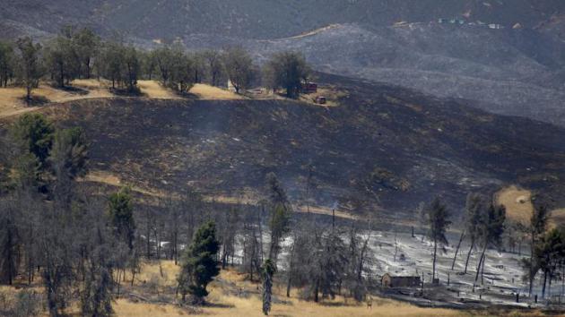
"Fiirefighters labored in scorching heat Sunday against five separate brush fires across Southern California as forecasters warned of more triple-digit temperatures in inland communities. The punishing heat wave broke records on Sunday in Lancaster, Palmdale and Sandberg, which saw highs of 108, 108 and 99 degrees, respectively. With a dry, high-pressure system parked over the Southwest, temperatures are expected to keep climbing through midweek, according to the National Weather Service."
(A brush fire near Castaic Lake burned 1,000 acres over the weekend and was only 10% contained as of Sunday afternoon. (Francine Orr / Los Angeles Times))
Weather Outlook
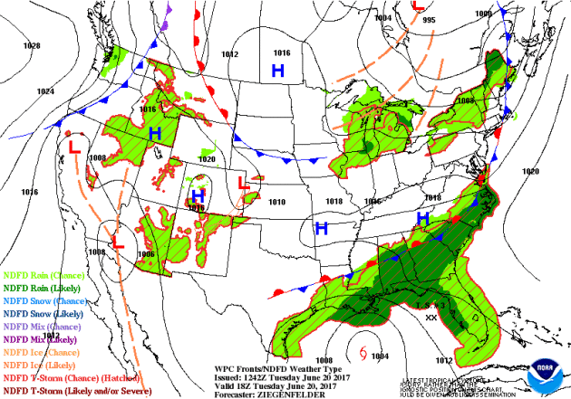
As we take a look at the national forecast, the main concern over the next few days will be the tropical system in the Gulf of Mexico. As the system slowly drifts along the coast through the week, heavy rain and gusty winds will be found there. Significant rainfall and flooding will be a major concern for coastal and inland communities as well. Another feature to follow will be the severe weather threat in the Central US Wednesday and Thursday, which could also prompt heavy rain and isolated flood concerns.
 _________________________________________________________________
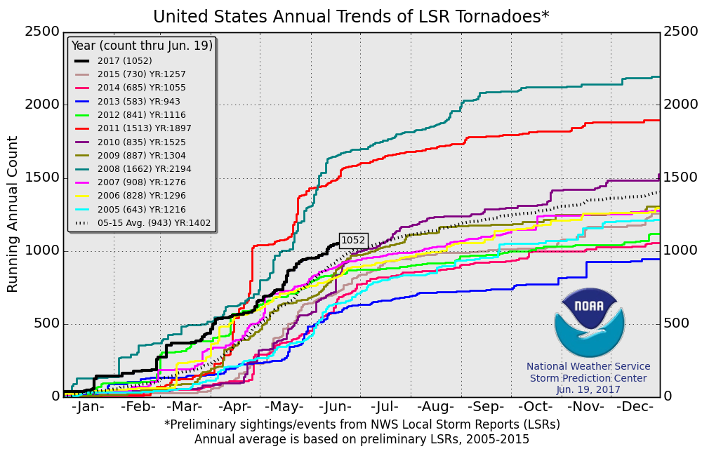
PRELIMINARY 2017 Tornado Count
According to NOAA's SPC, the PRELIMINARY 2017 tornado count is 1052 (through June 19). Note that is the most active year for tornadoes since 2011, when there were nearly 1,500 tornadoes. Keep in mind there was a major tornado outbreak in the Gulf Coast region from April 25-28, 2011 that spawned nearly 500 tornadoes, some of which were deadly. That outbreak is known as the Super Outbreak of 2011 and has gone down in history as one of the biggest, costliest and one of the deadliest tornado outbreaks in history.
________________________________________________________________________
Summer arrives with a few late days storms Wednesday
By Todd Nelson, filling in for Douglas
By Todd Nelson, filling in for Douglas
Happy Summer! While most of us were sleeping, the sun's most direct rays were shining over the Tropic of Cancer at 23.5 degrees latitude north marking the start of summer for us in the northern hemisphere. Daylight is at its peak right now, with Minneapolis seeing nearly 15 and half hours of daylight, nearly 7 hours of additional daylight since the winter solstice 6 months ago.
I have to admit, this is probably one of my favorite times of the year. It stays light until after 10PM and it gets light before 4AM. Chirping birds, growing gardens and plenty of lake or pool worthy days makes enduring the long Minnesota winter well worth it! We certainly earn our summers here, don't we?
Spotty late day storms bubble up across southern Minnesota Wednesday, some of which could be a little strong. Cool exhaust on the back side of this system brings temps well below average for the upcoming weekend. Some will have a tough time reaching 70 degrees. The extended forecast suggests warm and muggy weather returning by the 4th. Stay tuned!
______________________________________________________
______________________________________________________
Extended Forecast
WEDNESDAY: Happy Summer! More showers, a few T-storms late. Winds: SSE 5-13. High: 78
WEDNESDAY NIGHT: Storms possible early, then clearing. Winds: SSE 5-10. Low: 63
THURSDAY: Some sun. Lingering T-shower, mainly southern MN. Winds: WSW 5-15. High: 80
FRIDAY: Fresh breeze. Stray PM shower? Winds: NW 10-15. Wake-up: 58. High: 74
SATURDAY: Cool for June. Passing PM shower. Winds: WNW 10-15. Wake-up: 57. High: 70
SUNDAY: Still cool. A few more peeks of sun. Winds: NW 7-12. Wake-up: 55. High: 71
MONDAY: A little warmer. Few PM sprinkles. Winds: W 5-10. Wake-up: 55. High: 76
TUESDAY: Mix of clouds and sun. Nothing rough. Winds: W 5-10. Wake-up: 55. High: 78.
_______________________________________________________
_______________________________________________________
This Day in Weather History
June 21st
June 21st
1989: Fairmont has a wind gust of 76 mph during a severe thunderstorm.
________________________________________________________
________________________________________________________
Average High/Low for Minneapolis
June 21st
June 21st
Average High: 81F (Record: 95F set in 1910)
Average Low: 61F (Record: 39F set in 1992)
Average Low: 61F (Record: 39F set in 1992)
Record Rainfall: 2.95" set in 2002
_________________________________________________________
_________________________________________________________
Sunrise/Sunset Times for Minneapolis
June 21st
June 21st
Sunrise: 5:27am
Sunset: 9:03pm
Sunset: 9:03pm
Hours of Daylight: 15hours & 36mins & 48 seconds
Daylight gained since yesterday: Less than 1min
Daylight gained since winter solstice (December 21st): ~6hours & 50mins
__________________________________________________________
Daylight gained since winter solstice (December 21st): ~6hours & 50mins
__________________________________________________________
Moon Phase for June 20th at Midnight
2.8 Days Before New Moon
2.8 Days Before New Moon
_____________________________________________________________
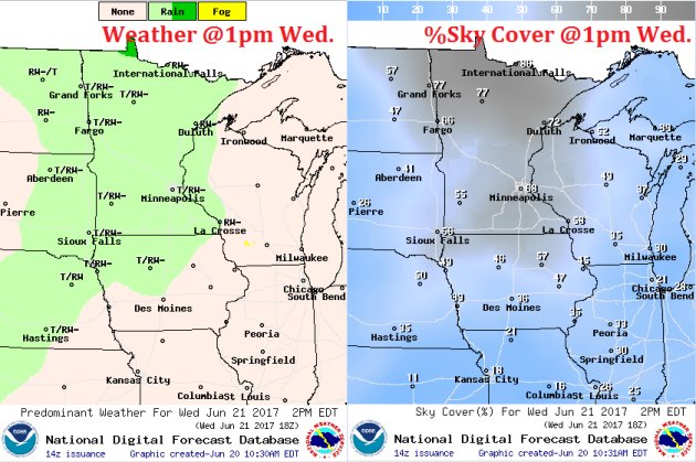
Weather Outlook for Wednesday
Winds will be fairly light across the region once again Wednesday, but could gust up to 10mph-15mph during the afternoon as a weak storm system approaches from the west. This front will also bring us a chance of a few spotty showers/storms late in the day Wednesday.
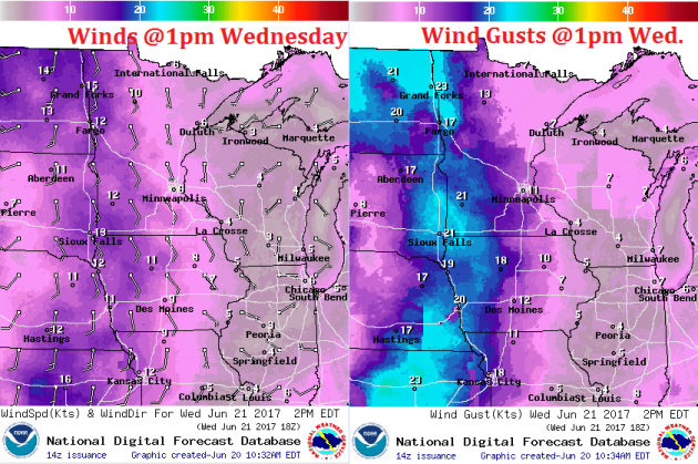
Weather Outlook for Wednesday
Wednesday will start on a fairly sunny note, but a weak front approaching front from the west will bring a chance of a few spotty showers and storms into the region later in the afternoon/evening. Some of these spotty storms could linger into Thursday, but the don't appear to be very widespread and certainly won't produce much heavy rainfall potential.
__________________________________________________________________________
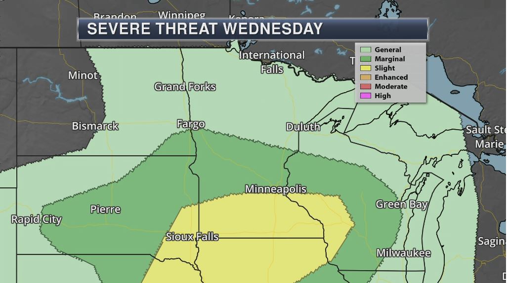
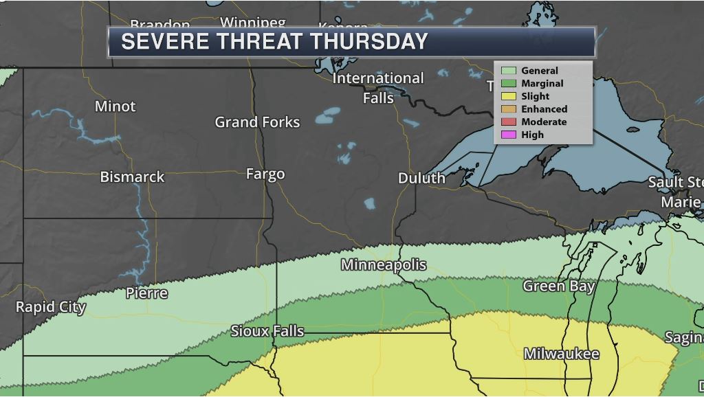
Severe Threats Ahead?
Here are the severe weather concerns across the state on Wednesday and Thursday. According to NOAA's SPC, there is a SLIGHT risk of severe weather across southern MN and southwestern WI late Wednesday with a MARGINAL risk across central MN. On Thursday, the best potential of strong to severe storms shifts southeast. Keep in mind that large hail and gusty winds will be the main concerns with these storms.
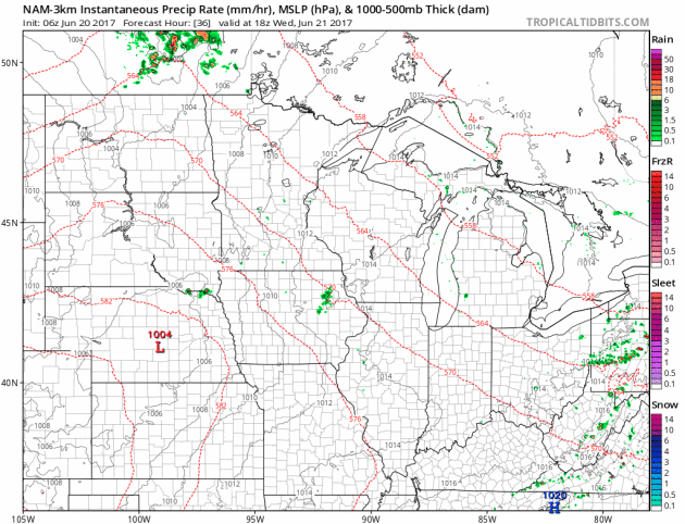
Midweek Storms, Some Strong With Locally Heavy Rainfall
Here's the weather outlook from Wednesday to Thursday, which shows our next chance of showers and storms pushing through the region. Note that the best potential of storms will be late Wednesday and again Thursday. Some of these storms could be strong to severe with locally heavy rain.
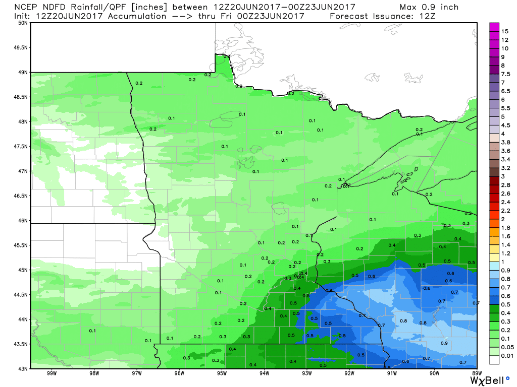
Extended Rainfall Forecast
Here's the extended rainfall forecast through PM Thursday, which suggests nearly 0.50" to 0.75" rain across southeastern MN, while 0.25" to 0.50" maybe possible across the Twin Cities. Of course, this will be dependent upon where thunderstorms develop.
________________________________________________________________________
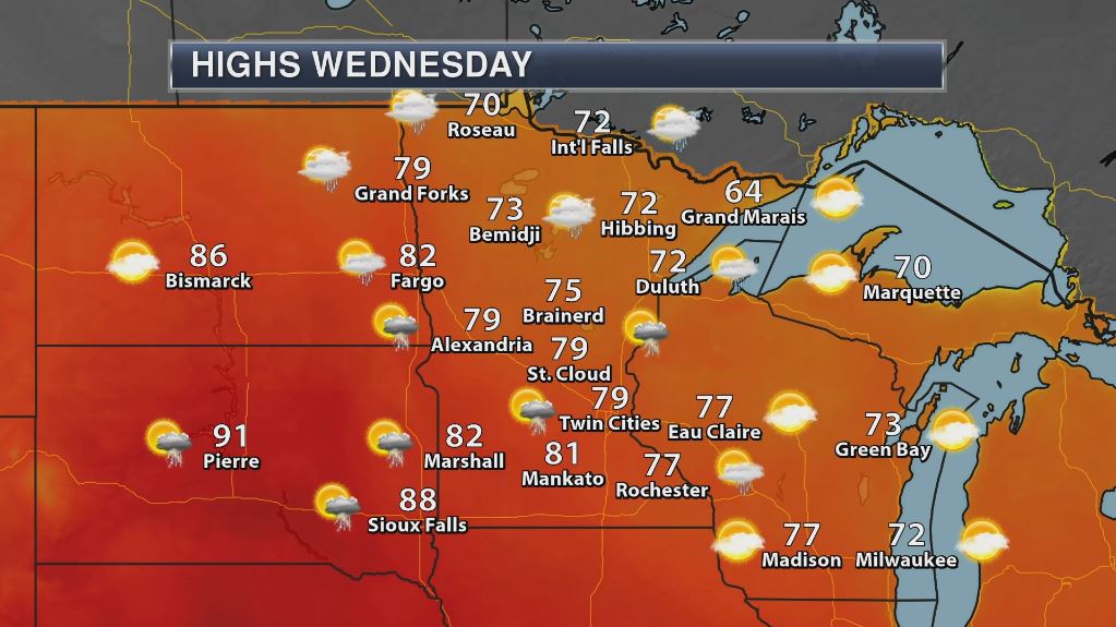
Weather Outlook For Wednesday
Wednesday will be one of our warmest days of the week with highs in the 70s and 80s. A storm system scooting through the region will allow a little heat and humidity to sneak back into the region, which may be enough to touch off some strong to severe thunderstorms.
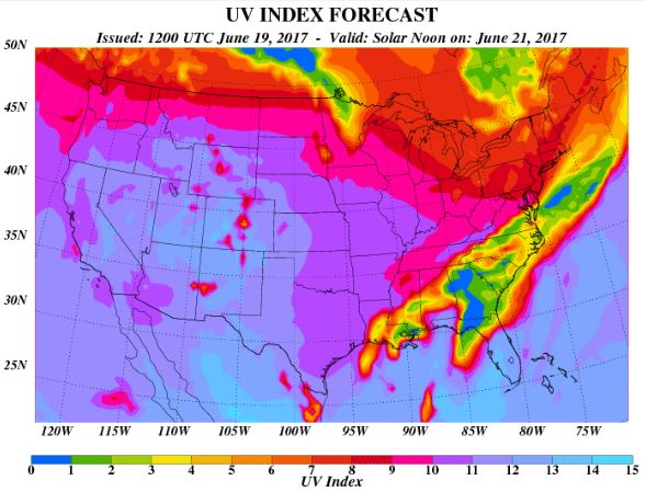
UV Index for Wednesday - HIGH
The UV Index will be considered HIGH across much of the state of Minnesota on Wednesday, which means that it will only 15 to 20 minutes or less to burn unprotected skin. With that said, if you are planning on spending any extended length of time outside, make sure you wear appropriate attire and lather on the sun block!
_____________________________________________________________
Weather Outlook for Thursday
There maybe a few lingering T-showers across the region on Thursday, but the heaviest and strongest storms look to settle south of the region. With that said, temperatures will fall to slightly below average levels across much of the state and look to stay that way over the next several days. The nice thing is that humidity values will remain low and with the sun at it's strongest in mid June, any sunshine that pops out will feel quite nice!

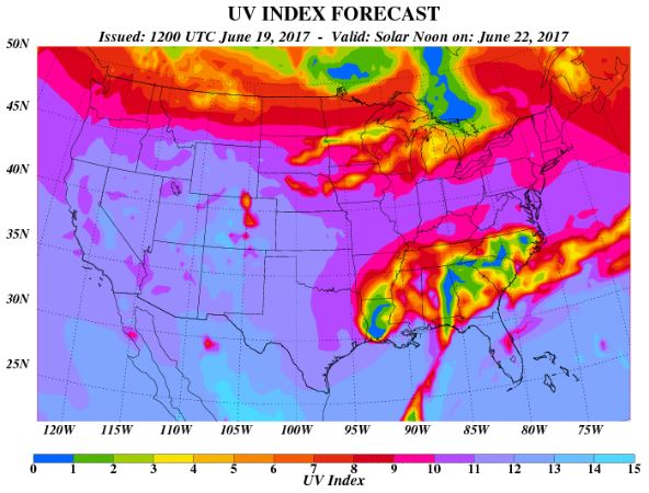
UV Index for Thursday - HIGH
The UV Index will be considered HIGH across much of the state of Minnesota on Thursday, which means that it will only 15 to 20 minutes or less to burn unprotected skin. With that said, if you are planning on spending any extended length of time outside, make sure you wear appropriate attire and lather on the sun block!
_____________________________________________________________________________
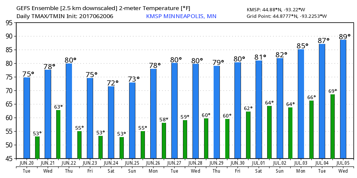
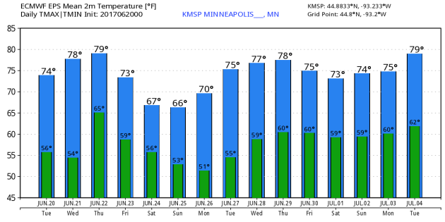
Temperature Outlook
Here's the temperature outlook from 2 different models through into the early part of July. After a slight warm up back to near 80F on Wednesday & Thursday, the weekend looks quite chilly with highs that may struggle to get to 70F! After the brief weekend cool snap, temperatures look to steadily warm as we approach the the start of July. There are some indications that it could be hot & sticky around the 4th of July, but it's a little too early to tell. Stay tuned!
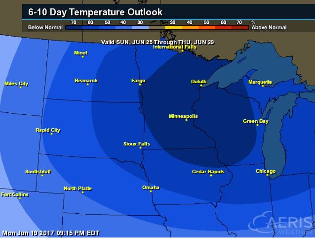
8 to 14 Day Temperature Outlook
According to NOAA's CPC, the extended temperature outlook through June 29th suggests much cooler than average temperatures across the entire region. After a very warm start to the month, temperatures looks to remain cool as we end the month. As of June 19th, the Twin Cities was still running nearly 7F above average for the month, but with continued cooler temperatures, we'll see how June ends.
___________________________________________________________
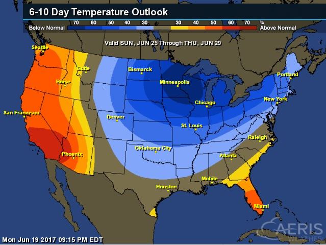
Extended Temperature Outlook
According to NOAA's CPC, the extended temperature outlook through June 29th shows much cooler than average temperatures across a good chunk of the central US and into the Northeast. Warmer than average temperatures look to continue across the Western third of the nation and across Florida.
 ____________________________________________________________
Temperature Trend
Here's the temperature trend through the end of the month, which shows cool exhaust from Canada continuing to settle south of the border over the next several days. The coolest batch of Canadian air may come in waves; one chunk over the upcoming weekend with another smaller batch moving into the Midwest/Great Lakes by the early/middle part of next week. Meanwhile, the Western US looks to remain quite hot through the end of the month.
.gif)
Weather Outlook This Week
The weather outlook over the next couple of days shows the tropical system in the Gulf of Mexico moving north into the Lower Mississippi Valley with gusty winds and significant rain and flooding potential. Meanwhile, scattered storms breakout across the Central US, some of which could be strong to severe with locally heavy rains.
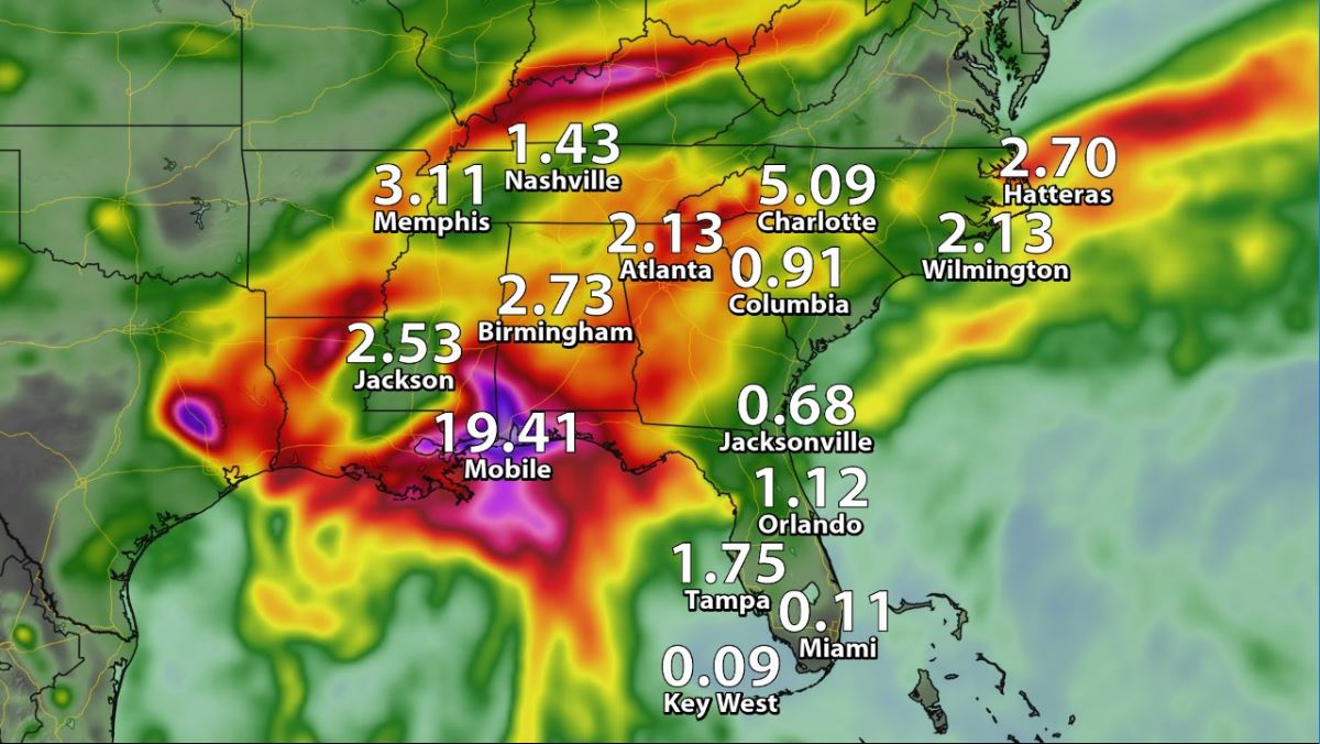
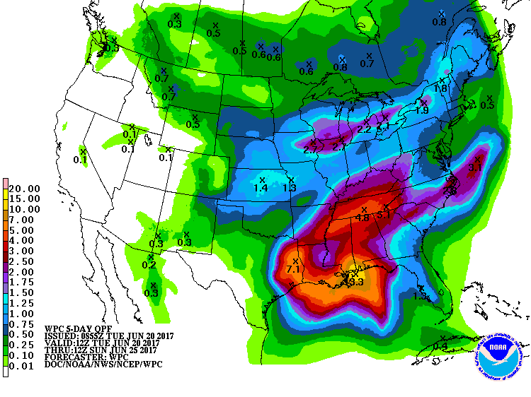
5 Day Precipitation Outlook
According to NOAA's WPC, the next several days could produce areas of locally heavy rainfall across the South US where some 6" to 10"+ rainfall tallies can't be ruled out. Note that some of this tropical moisture may lift northeast into the Ohio and Tennessee Valley through the upcoming weekend, which could also lead to areas of flooding. Another batch of heavier rain could fall across the Midwest and Great Lakes Region, which would be associated with scattered to spotty severe storms through the end of the week.
 ____________________________________________________________________
"Weather system revamp hopes to bring sunshine to US economy"
"New legislation requires NOAA to improve weather research and forecasting, boosting industries from farming and airlines and improving the public warning system"
"Farmers have been obsessed with weather for thousands of years. Ancient Greeks and Babylonians sought guidance on planting and harvest by surveying the sky for patterns in clouds and stars and by communing with gods – through prayers and animal sacrifices. Modern-day farmers, such as Steve Pitstick, a fifth-generation farmer in Illinois, count on sophisticated instruments for predicting the weather instead. During the planting season, Pitstick says, he checks the weather forecast three or four times a day. Too much rain means he can’t plant because the heavy machinery will compact the wet soil, smothering the seeds; too little and the seeds won’t germinate. “Weather is huge in our business. We use the forecast during planting season to get a sense of what we’re doing and to know the level of urgency to get the crops planted,” says Pitstick, who grows corn and soybeans. Weather is big business in many other industries, too, and an ambitious plan is underway to revamp the country’s weather forecast system. It’s the Weather Research and Forecasting Innovation Act of 2017, the first major weather legislation that Congress has passed since the early 1990s."
_______________________________________________________________
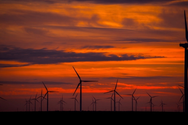
"The U.S. Hit a Wind and Solar Power Milestone in March"
"Ten percent of all of the electricity generated in the U.S. in March came from wind and solar power, marking the first such milestone in U.S. history, according to a new U.S. Energy Information Administration report. The EIA estimates that wind and solar farms likely generated 10 percent of America’s electricity in April as well, which would be another first, according to the report. This year’s milestone shows that renewables are becoming a major source of electricity in the U.S. and can no longer be considered “alternative” energy, said Christopher Clack, CEO of the power grid modeling firm Vibrant Clean Energy and a former National Oceanic and Atmospheric Administration researcher. The report’s findings represent a marked increased from March 2016, when wind and solar generated 8.6 percent of total U.S. electricity. Overall, about 7 percent of U.S. electricity comes from wind and solar annually, up from less than 1 percent a decade ago. Texas is the country’s biggest wind power producer and California is the largest solar producer."
(The Los Vientos wind farm in Texas. Credit: Duke Energy/flickr)
_______________________________________________________
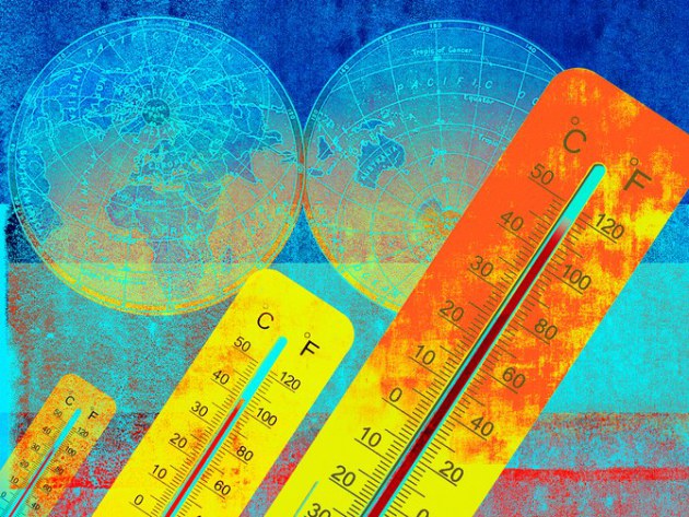
"IS IT SO BAD IF THE WORLD GETS A LITTLE HOTTER? UH, YEAH"
"MANY OF US share some dim apprehension that the world is flying out of control, that the center cannot hold. Raging wildfires, once-in-1,000-year storms, and lethal heat waves have become fixtures of the evening news—and all this after the planet has warmed by less than 1 degree Celsius above preindustrial temperatures. But here’s where it gets really scary. If humanity burns through all its fossil fuel reserves, there is the potential to warm the planet by perhaps more than 10 degrees Celsius and raise sea levels by hundreds of feet. This is a warming spike comparable in magnitude to that so far measured for the End-Permian mass extinction. If the worst-case scenarios come to pass, today’s modestly menacing ocean-climate system will seem quaint. Even warming to half of that amount would create a planet that would have nothing to do with the one on which humans evolved, or on which civilization has been built. The last time it was 4 degrees warmer there was no ice at either pole and sea level was hundreds of feet higher than it is today."
(Image Credit: GETTY IMAGES via Wired)
_______________________________________________________
"Unusual weather in Antarctica leads to rain and a Texas-sized melt"
"An area larger than the state of Texas in West Antarctica melted to an unusual degree last year, with pools of the meltwater remaining on the surface for as long as 15 days. That’s trouble, since meltwater can accelerate the thawing already occurring from warming ocean temperatures. West Antarctica alone could contribute 10 feet of sea level rise, according to a 2009 paper published in Science. This area in the Ross Ice Shelf, the world’s largest chunk of floating ice, likely melted at its surface because of a particularly strong 2015–2016 El Niño event, which brought warm and moist sea air to the area, according to the study published today in Nature Communications. El Niños have caused melting atop the Ross Ice Shelf before, but this time it lasted unusually long, according to the paper. It appears it also rained on the ice shelf and other parts of West Antarctica. That could made it easier for the snow surface to melt."
(Image Credit: NOAA)

_______________________________________________________
Thanks for checking in and don't forget to follow me on Twitter @TNelsonWX

No comments:
Post a Comment