_______________________________________________
An Average July - Unsettled Weather AheadBy D.J. Kayser, filling in for Douglas
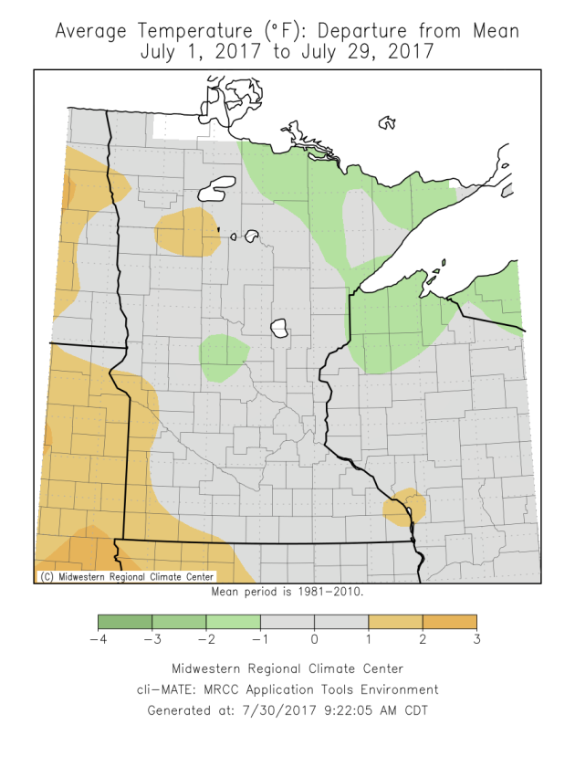
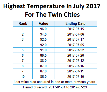
July is almost gone, and it’s actually been a fairly average month in the temperature department across the Twin Cities. We have recorded five days this month with a high in the 90s, which is right on average for July. Our average temperature has been a little over a degree above average, which will make this the second month in a row with an above average monthly temperature – and the 22nd month of the past 23.
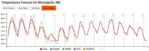
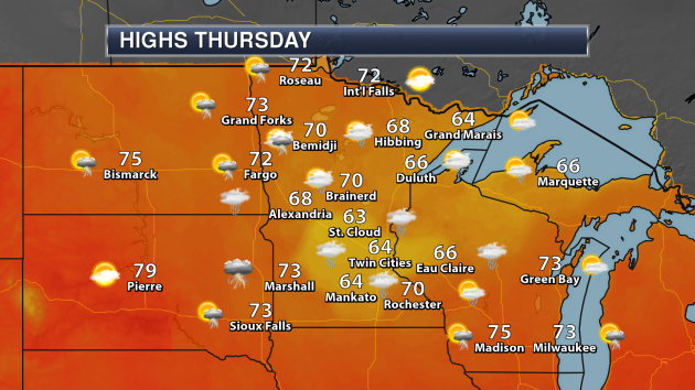
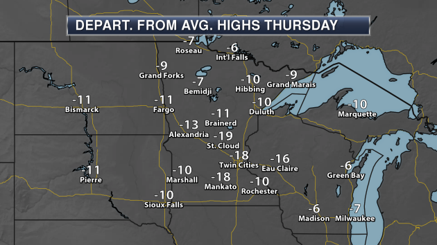
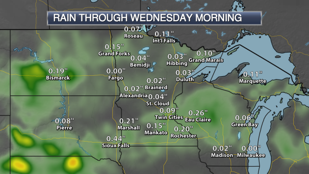
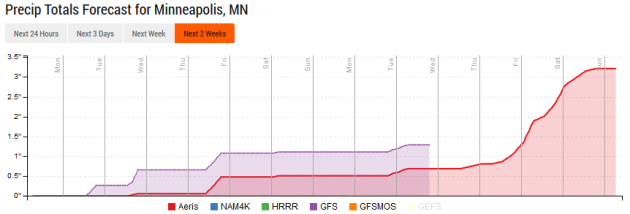
Temperatures to end out the month will continue to be around average, with highs in the low to mid 80s today. However, a change in the weather pattern comes in later this week, bringing with it rain and much cooler weather. Rain chances will be highest Tuesday and Thursday across the Twin Cities, with totals of a half an inch or more by the end of the week. The second system will help usher in air that is far below average for early August. Highs on Thursday will be stuck in the 60s – a good 10-20 degrees below average! The cooler weather won’t last – highs will be back around 80 again for the weekend.
_______________________________________________
Twin Cities Extended Forecast
MONDAY: Enjoy the sunshine! High 84. Low 66. Chance of precipitation 10%. Wind S 3-8 mph.
TUESDAY: Afternoon storms. Some strong? High 84. Low 64. Chance of precipitation 40%. Wind W 3-8 mph.
WEDNESDAY: Mainly cloudy. Late day rain. High 78. Low 59. Chance of precipitation 20%. Wind NE 3-8 mph.
THURSDAY: Showers. Feeling like late September. High 65. Low 57. Chance of precipitation 70%. Wind NE 5-10 mph.
FRIDAY: Warming back up. PM shower chance. High 74. Low 59. Chance of precipitation 20%. Wind N 5-10 mph.
SATURDAY: Afternoon clouds and isolated showers. High 77. Low 60. Chance of precipitation 20%. Wind NW 5-10 mph.
SUNDAY: Sunny skies. High 80. Low 60. Chance of precipitation 10%. Wind SE 3-8 mph.
_______________________________________________
This Day in Weather History
July 31st
July 31st
1961: Very heavy rain falls at Albert Lea, where 6.7 inches is recorded in 24 hours.
_______________________________________________
Average Temperatures & Precipitation for Minneapolis
July 31st
July 31st
Average High: 83F (Record: 105F set in 1988)
Average Low: 64F (Record: 47F set in 1924)
Average Precipitation: 0.14" (Record: 0.79" set in 1911)
Average Low: 64F (Record: 47F set in 1924)
Average Precipitation: 0.14" (Record: 0.79" set in 1911)
________________________________________________
Sunrise/Sunset Times for Minneapolis
July 31st
July 31st
Sunrise: 5:57 AM
Sunset: 8:40 PM
Sunset: 8:40 PM
*Length Of Day: 14 hours, 42 minutes and 40 seconds
*Daylight Lost Since Yesterday: ~2 minute and 21 seconds
*Next Sunrise At/After 6 PM: August 2nd (6:00 AM)
*Next Sunset At/Before 8:30 PM: August 8th (8:29 PM)
*Daylight Lost Since Yesterday: ~2 minute and 21 seconds
*Next Sunrise At/After 6 PM: August 2nd (6:00 AM)
*Next Sunset At/Before 8:30 PM: August 8th (8:29 PM)
_______________________________________________
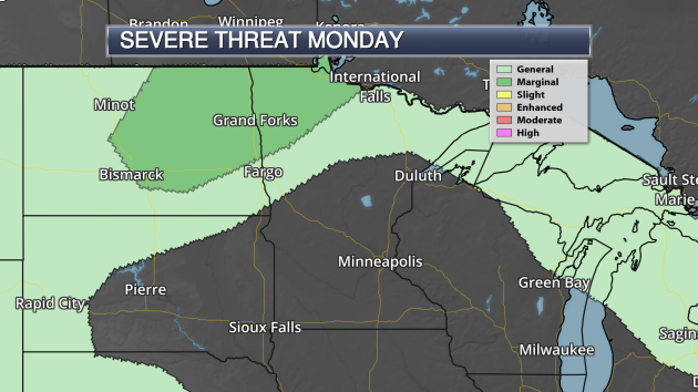
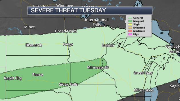
Minnesota Weather Outlook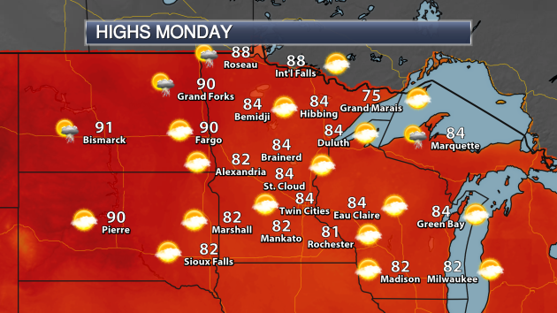
_______________________________________________
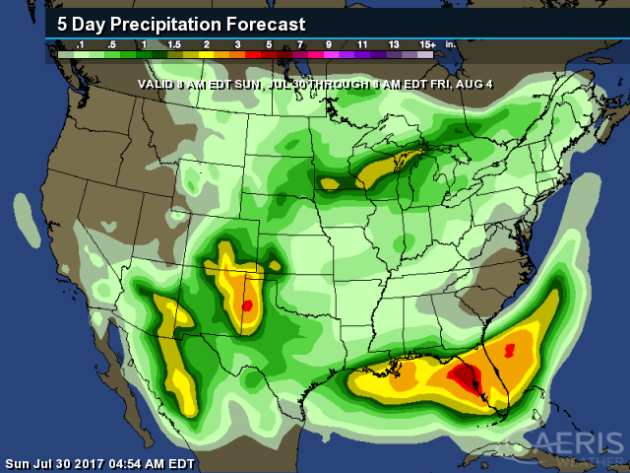
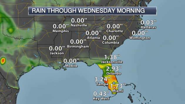
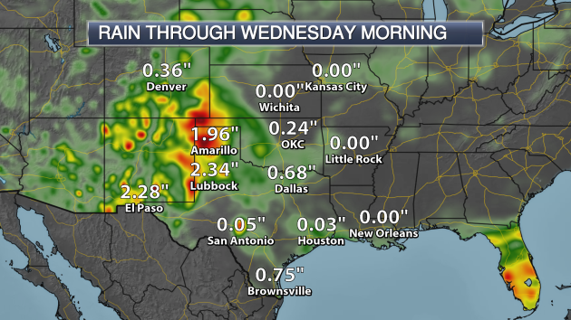
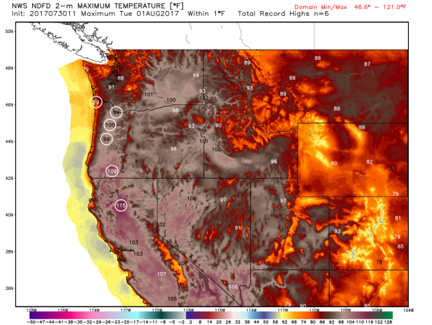
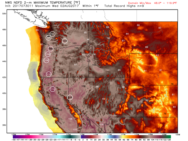
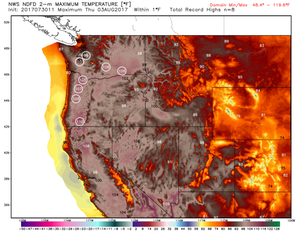
National Weather Outlook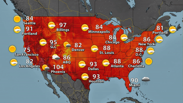
_______________________________________________
Tampa Bay - And The Next Major Hurricane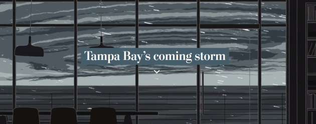
50/50 Chance Of Rain? Not In Canada

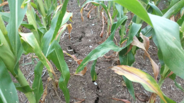
Iowa And Nebraska Farmers Taking A Hit Due To Dry Conditions
Rome Is Avoiding Water Rationing In A Drought... At The Moment
Drought isn't only striking areas in the U.S. - Rome has seen a drought, but they are avoiding water rationing at the moment. More from Reuters: "ROME (Reuters) - Rome water utility ACEA said on Friday the Italian capital had avoided water rationing after regional authorities modified a decree banning withdrawals from a drought-hit lake. The city's mayor had called on the government to stop water rationing, which ACEA had said would have to be introduced on July 31 if it could not draw on Lake Bracciano, north of Rome. "
11th Lightning Death Of 2017
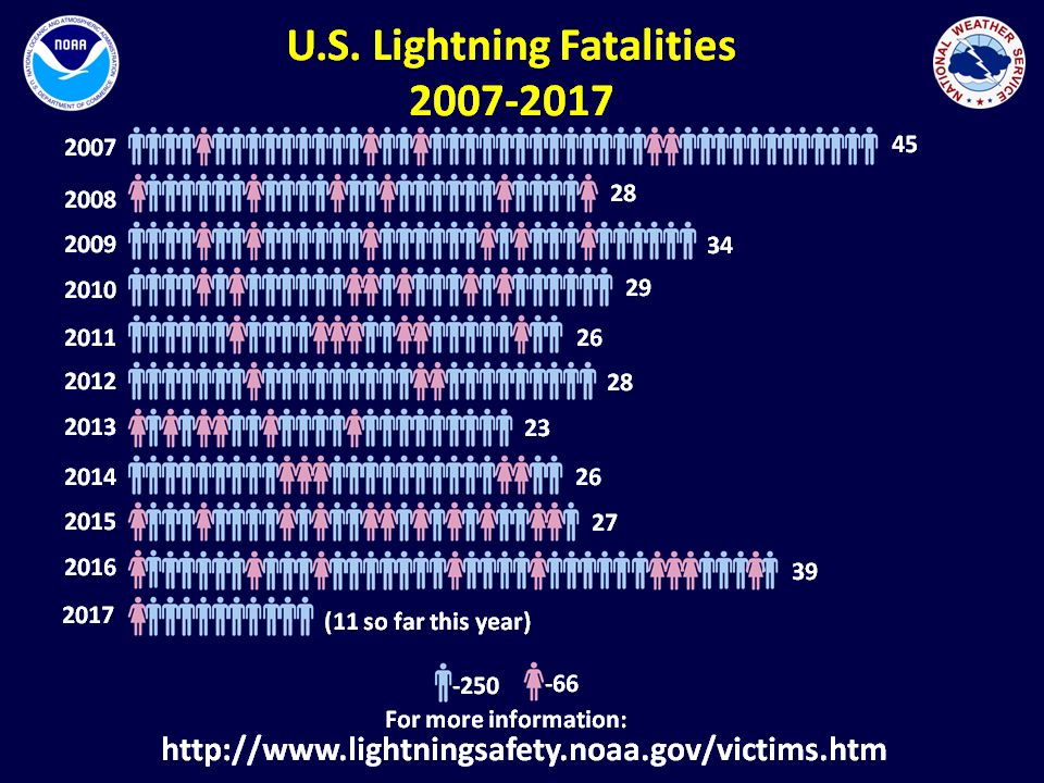
Unfortunately, the 11th lightning death of 2017 in the U.S. occurred Friday near Satellite Beach, FL. More from Florida Today: "Lightning struck two men, killing one, just north of Satellite Beach on Friday afternoon, according to the Brevard County Sheriff's Office and Brevard County Fire Rescue. Brevard County Lifeguard Captain Ashley Nolan was the first to respond to help the men. The men were hit at SPRA Park in the 400 block of State Road A1A at the end of Berkeley Street."
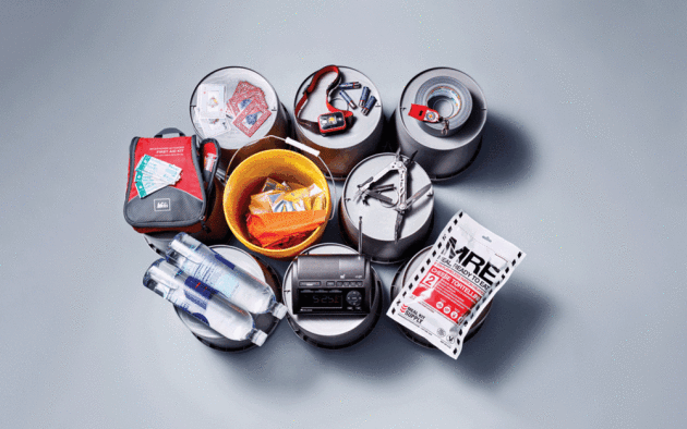
Must Have Weather Gear
Fish More Polluted From Climate Change?
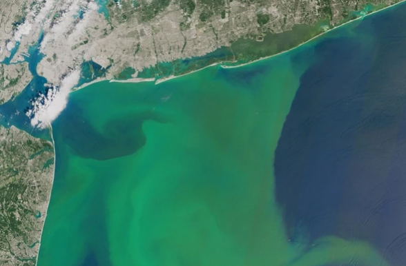
As
heavier rain events become more common with a warming climate, we could
see more fish being polluted due to increased nitrogen making it into
our waterways. More from Scientific American: "What
happens down on the farm could soon pose bigger problems downriver.
Water undergoes deadly changes when enough fertilizers seep into rivers,
lakes and streams. Algae growth explodes, oxygen levels drop and fish
either leave the waterway or suffocate. Since the 1970s, large swaths of
the Gulf of Mexico have transformed into so-called dead zones —
covering an average area about the size of Connecticut — as agricultural
runoff filters from the Mississippi River. The Chesapeake Bay and other
fisheries have struggled with the problem, too." (Image: Phytoplankton blooms off the Atlantic coast in August 2015. Credit: Joshua Stevens/NASA Earth Observatory)
_______________________________________________
Thanks for checking in and have a great Monday! Don't forget to follow me on Twitter (@dkayserwx) and like me on Facebook (Meteorologist D.J. Kayser)!
- D.J. Kayser

No comments:
Post a Comment