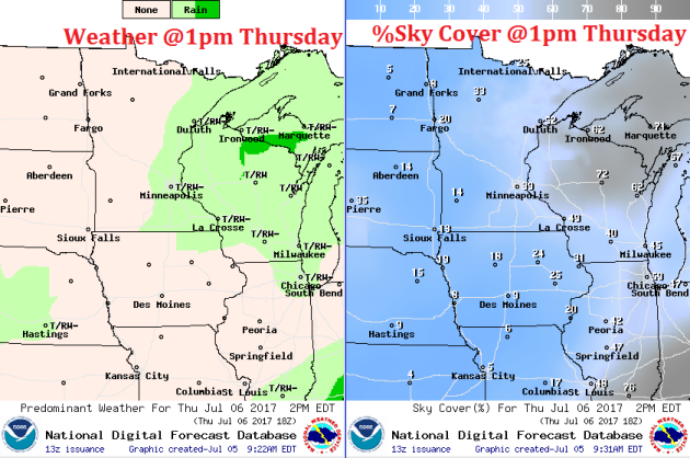
Unsettled Skies
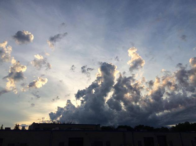
Here's a picture of a towering cumulus cloud from early Wednesday morning. The atmosphere has been very unsettled as of late with showers and storms developing across the region. We'll have another somewhat unsettled day on Thursday with more storms developing late in the day, some of which could be strong to severe, mainly across parts of Wisconsin.
Visible Satellite on Wednesday
After a few thunderstorms early Wednesday, skies cleared across much of the state. It was a bright and steamy Wednesday with heat index values well into the 90's.
.gif)
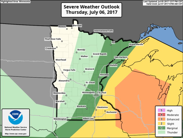
Severe Threat on Thursday
According to NOAA's SPC, there is a chance of severe storms across parts of eastern Minnesota and most of Wisconsin. Note that much of Wisconsin is actually under an ENHANCED risk of severe weather, which means that widely scattered strong to severe storms maybe possible.
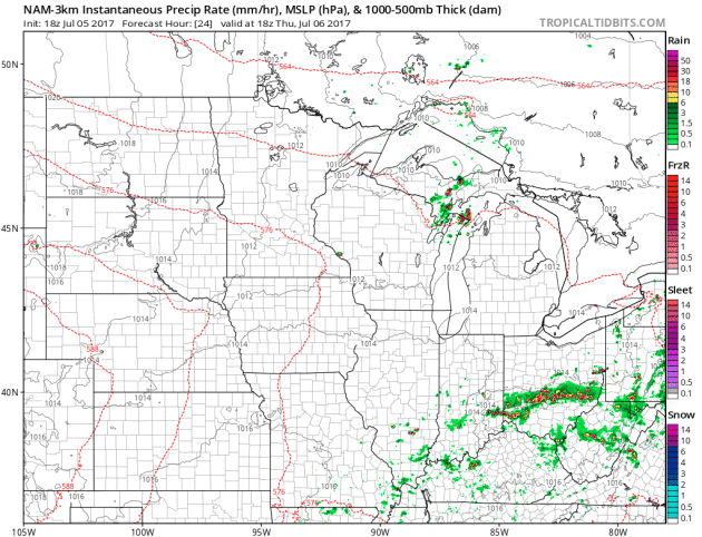
Simulated Radar
Here's the simulated radar from Thursday to Friday, which suggests scattered strong to severe storms breaking out along the Minnesota and Wisconsin border late Thursday into early Friday. Note that some of these storms could produce damaging winds, large hail and heavy downpours.
_____________________________________________________________
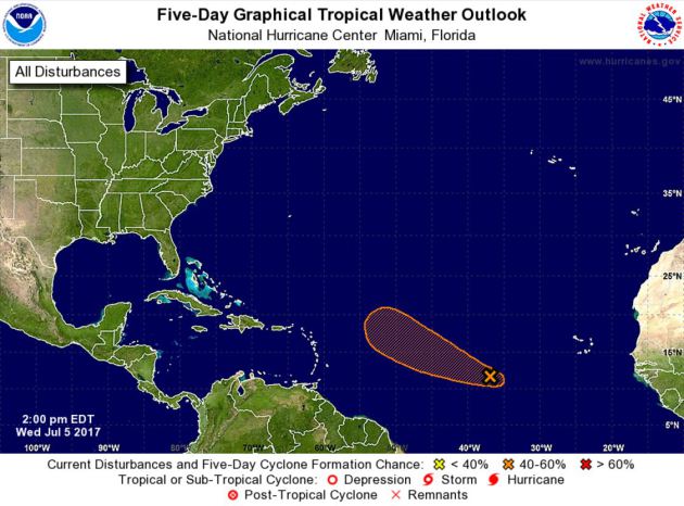
Atlantic Outlook
The National Hurricane Center is keeping an eye on a wave of energy in the Atlantic basin. Although there doesn't appear to be much organization just yet, there is a medium chance of tropical formation within the next 5 days.
Atlantic Outlook
According to NOAA's NHC, the wave of energy in the Atlantic basin has a medium chance of tropical formation within the next 5 days. The current path is to drift northwest across the central Atlantic. Note that we've already had three named storms this season: ARLENE, BRET and CINDY. The next name on the list would be DON. Stay tuned...
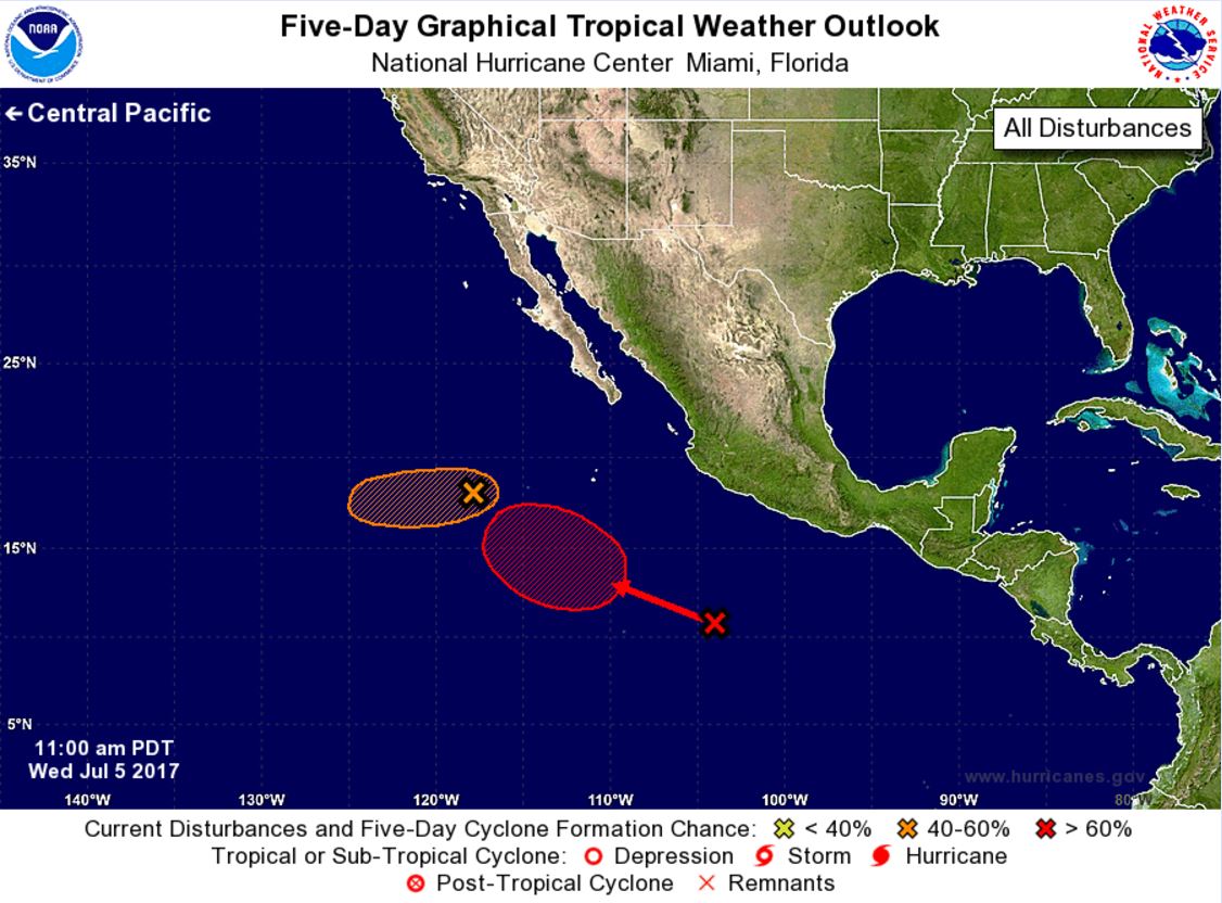
Eastern Pacific Outlook
Here's a look at another wave of energy in the Eastern Pacific that the National Hurricane Center is keeping their eye on. This particular wave also has a high probability of tropical formation within the next 5 days.
Eastern Pacific Outlook
According to NOAA's NHC, there are two different waves of energy, one which has a high probability of tropical formation within the next 5 days. The good news is that if these storms develop any further, they look to drift west, away from any major landmass. Note that we've already had four named storms in the Eastern Pacific this season: ADRIAN, BEATRIZ, CALVIN and DORA. DORA was the only storm to reach hurricane status. EUGENE is the next name on the list.
 ______________________________________________________________________
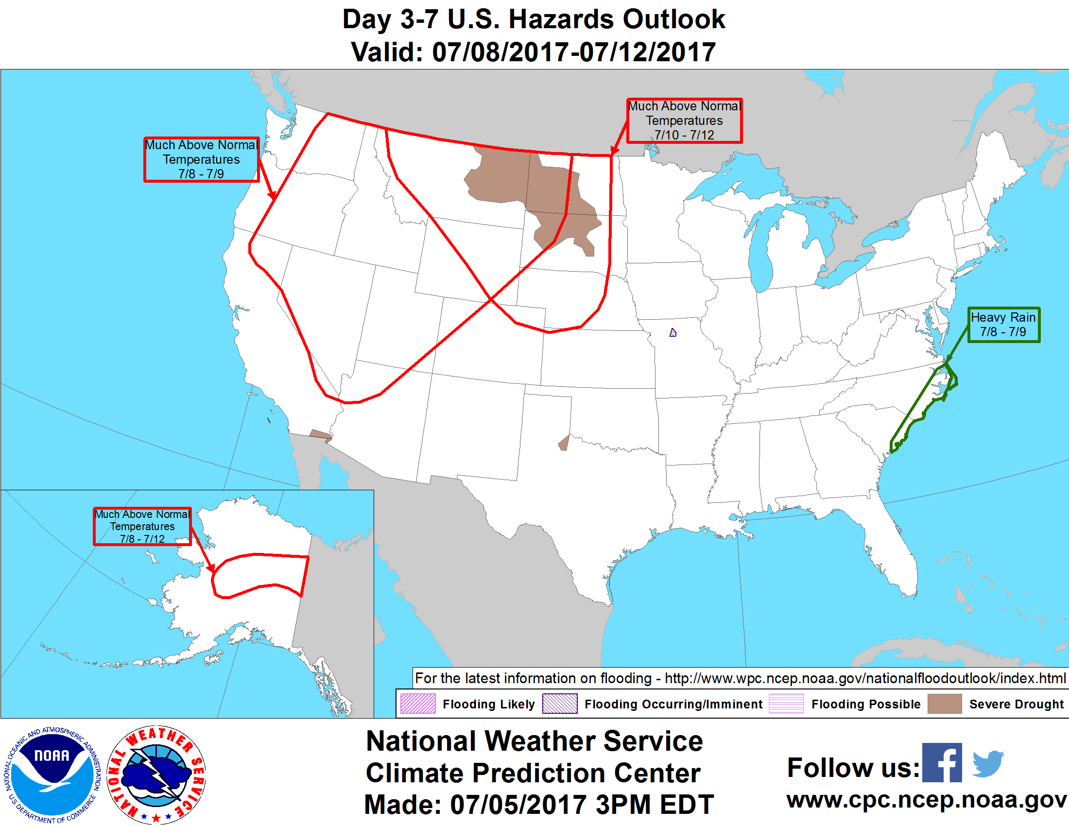
According to NOAA, here are the potential weather hazards as we head into the weekend and early next week:
**Much above-normal temperatures for parts of the western U.S. and northern high Plains, Sat-Sun, Jul 8-9.
**Much above-normal temperatures for much of the northern and central Rockies and northern and central Great Plains, Mon-Wed, Jul 10-12.
**Heavy rain for the coastal Carolinas, Sat-Sun, Jul 8-9.
**Much above-normal temperatures for parts of the interior mainland of Alaska, Sat-Wed, Jul 8-12.
**Flooding occurring or imminent across parts of Missouri.
**High risk of much above-normal temperatures for the northern Great Plains, Thu-Fri, July 13-14.
**Moderate risk of much above-normal temperatures for portions of the northern Rockies and northern to central Great Plains, Thu-Sat, Jul 13-15.
**Slight risk of much above-normal temperatures for portions of the western U.S., Great Plains, and upper Mississippi Valley, Thu-Wed, Jul 13-19.
**Slight risk of much above-normal temperatures for parts of interior mainland Alaska, Thu-Sat, Jul 13-15.
**Severe Drought across the Southern Plains, California, Hawaii, the Northern Plains, and the Southwest.
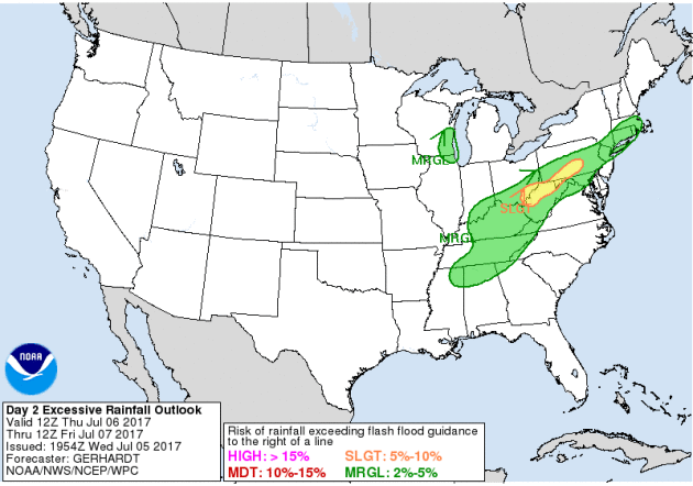
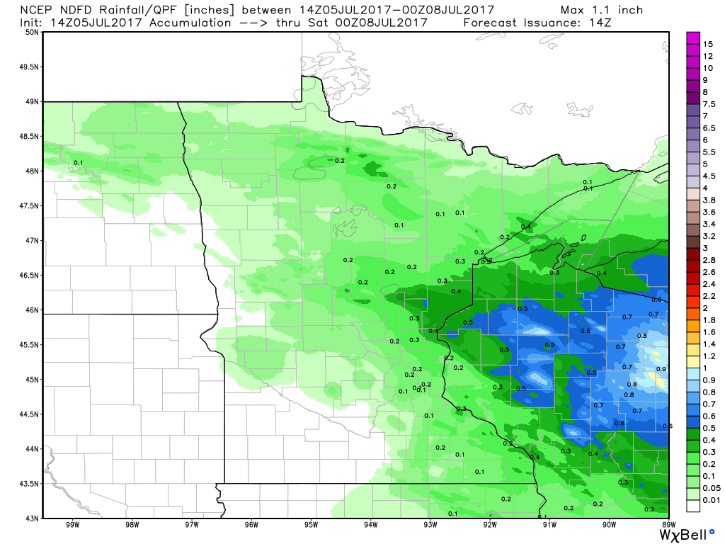
Flood Concerns Thursday
According to NOAA, excessive rainfall will be possible across parts of the Eastern US, especially across northern West Virginia. There is also a marginal threat of excessive rainfall across southeastern Wisconsin.
Take a look at the heavy rain potential across the Upper Midwest through Thursday morning. Note that some locations could see 1" or more.

________________________________________________________
Weather Outlook
Here's the weather outlook through early next week, which suggests a little more unsettled weather in the eastern half of the country. Strong to severe storms maybe possible in a few locations through the end of the week along with locally heavy rainfall. Meanwhile, spotty storms will be possible in the western US, but it won't be as widely scattered. Also note that some monsoon thunderstorms will be possible in the Southwestern US!
.gif)
_________________________________________________________________
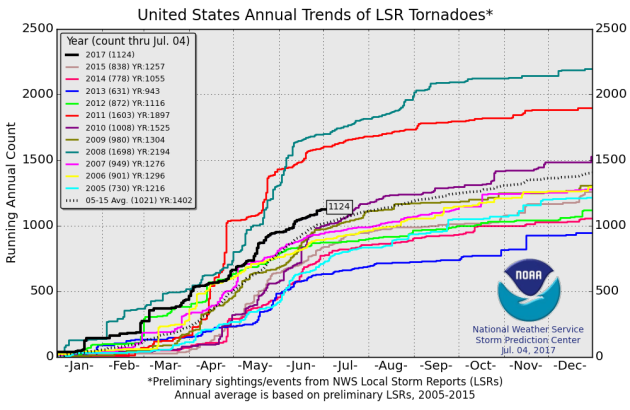
PRELIMINARY 2017 Tornado Count
According to NOAA's SPC, the PRELIMINARY 2017 tornado count is 1124 (through July 4). Note that is the most active year for tornadoes since 2011, when there were nearly 1,600 tornadoes. Keep in mind there was a major tornado outbreak in the Gulf Coast region from April 25-28, 2011 that spawned nearly 500 tornadoes, some of which were deadly. That outbreak is known as the Super Outbreak of 2011 and has gone down in history as one of the biggest, costliest and one of the deadliest tornado outbreaks in history.
_________________________________________________________________
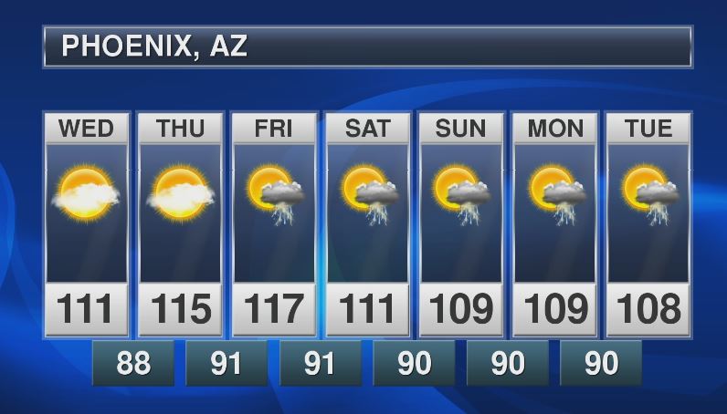
Extended Forecast for Phoenix, AZ
It's heating up again in the Southwest. Here's the extended forecast for Phoenix, AZ, which calls for high temperatures up to near 120F again by the end of the week! Also note the increase in thunderstorm potential! Monsoon season is officially underway in the Southwest and could bring storms into the Phoenix area by the end of the week as well.
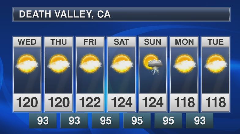
Death Valley, CA
With temperatures heating up in the Southwest, readings in Death Valley could approach 120F to 125F over the next several days. Also note that there could even be a chance of thunder by the end of the weekend!
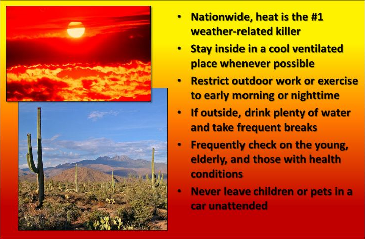
Heat is the #1 Weather Related Killer in the U.S.
"Nationwide, heat is the #1 weather-related killer. Stay inside in a cool ventilated place whenever possible. Restrict outdoor work or exercise to early morning or nighttime. If outside, drink plenty of water and take frequent breaks. Frequently check on the young, elderly, and those with health conditions. Never leave children or pets in a car unattended."
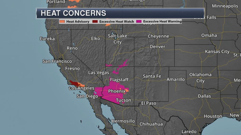
Excessive Heat Builds Again
The National Weather Service has issued a number of excessive heat advisories across the Southwest, including the Excessive Heat Warnings for the Phoenix on Friday, where temperatures could near 120F!
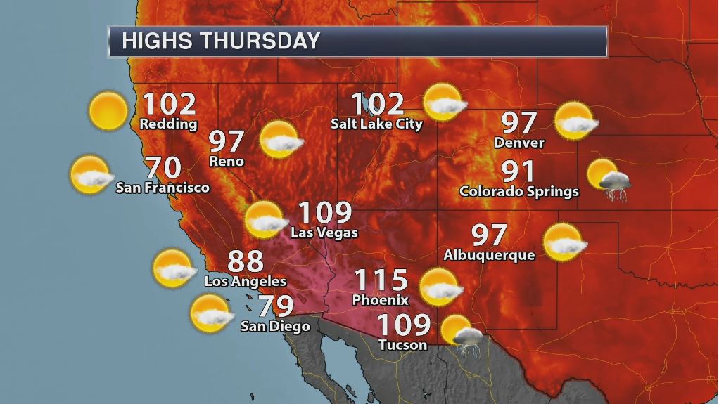
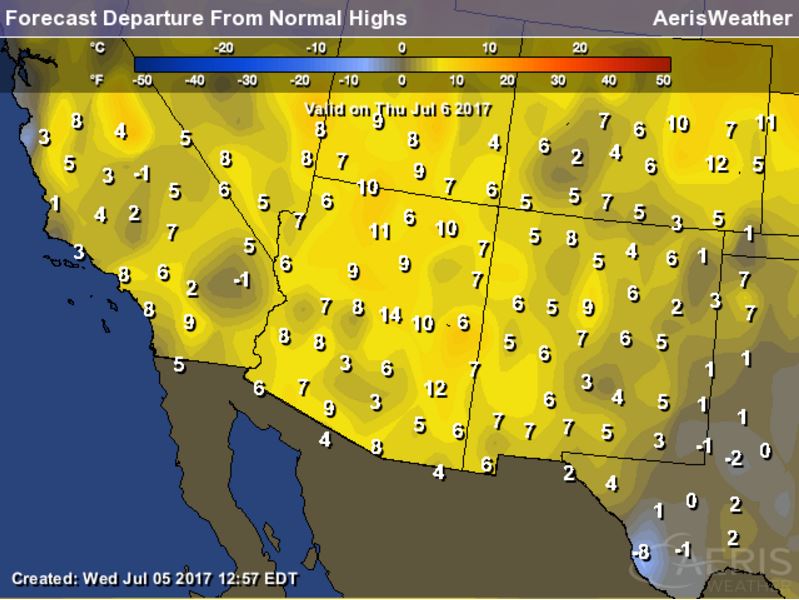
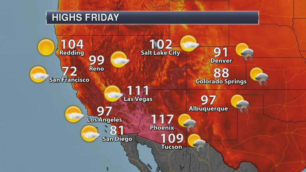
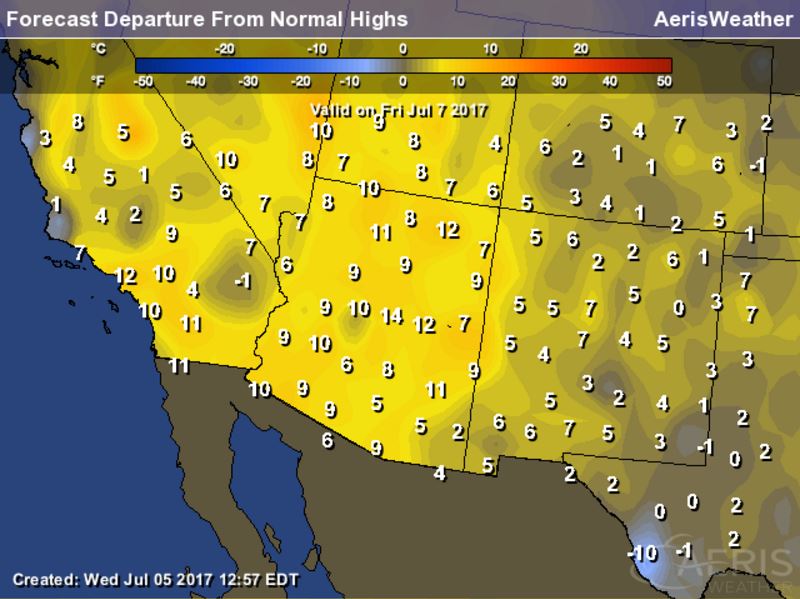
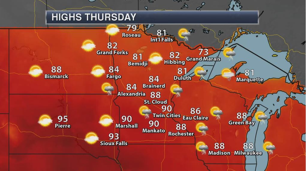
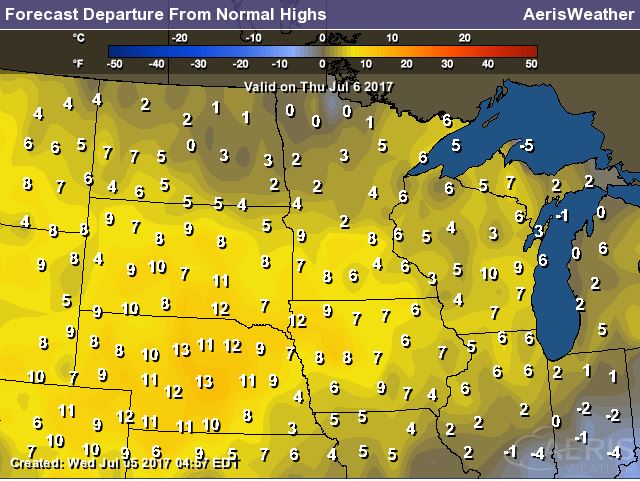
Thursday: High Temperatures, Highs Above Average & Records
High temperatures on Thursday across the Southwest will still be very warm with desert locales in the triple digits. Some spots could be as warm as 5F to 15F above average with a few records possible in Arizona.
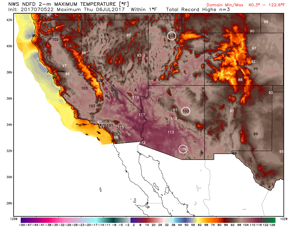
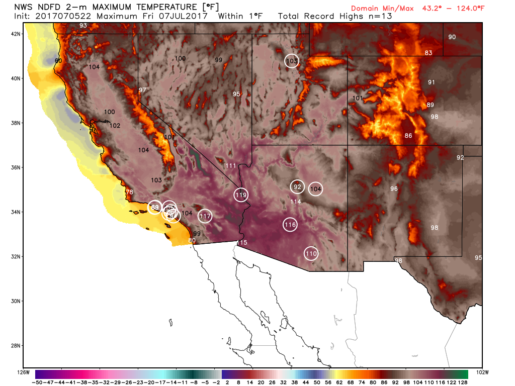
Friday: High Temperatures, Highs Above Average & Records
High temperatures on Friday will be even hotter with temperatures nearly 10F to 15F above average in many spots. Note how many record highs there could be across the region as well.
_______________________________________________________________________
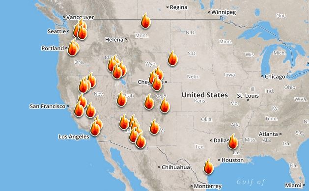
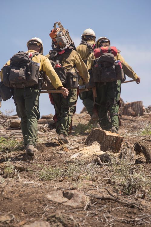
Ongoing Large Wildfires
Here's a look at the current wildfires across the Western US. The recent hot weather has allowed tinder dry conditions to develop, which has led to several wildfires popping up.
Brian Head Fire in Utah
According to Inciweb, one of the largest fires currently burning is located near Brian Head, Utah. There are nearly 1,400 people working on a fire that has consumed 68,407 acres since Saturday, June 17th. This was a human caused fire, which is still under investigation. Here was the latest weather report: "High pressure over the desert southwest has allowed strong warming, with temperatures even at 8500 feet reaching the lower 80s, with lower elevations reaching into the low 90s. Afternoon relative humidity continues below 15%, with some places still drying to below 10% relative humidity. By the end of the week, on Friday the 7th, moist and unstable air is expected to have entered the region and reached southern Utah. This will increase the relative humidity above the critical threshold, but will also dry thunderstorms with lightning. Outside of thunderstorms, winds will remain light through Saturday morning. Suppression repair continues in Branch I and III."
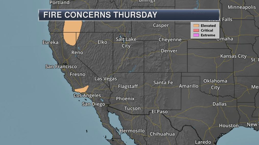
According to NOAA, there will be elevated fire weather conditions across parts of the Western US on Thursday. However, hot & dry conditions could help to fuel wildfire conditions across much of the region through the end of the week.
________________________________________________________________________
Steamy & somewhat stormy Thursday. Great Friday!
By Todd Nelson, filling in for Douglas
By Todd Nelson, filling in for Douglas
There is no way time is driving the speed limit. Am I right? Good grief, where does it go? I feel like we're doing 80 in a 60 miles per hour zone right now. The 4th is in our rear-view mirror and we've already lost nearly 9 minutes of daylight since the summer solstice 2 weeks ago. Slow down!
I lost a friend recently. He passed at 41 years young. A Minnesota sports fanatic with a great sense of humor. Sure makes you think when you lose someone close. Never take a day for granted. Thanks for the friendship Keith, you will be missed terribly.
Steamy sunshine gives way to a few late day rumbles today. Some storms could be severe with heavy downpours, mainly into Wisconsin. The front responsible for the unsettled weather will slide south of the region allowing cooler and less humid weather to filter in on Friday and Saturday. Sunday appears to be stickier and more unsettled, but not bad.
Enjoy the summer weather while you can. Go jump in a lake and where your flip flops proudly. The State Fair is only 7 weeks away - YIKES!
______________________________________________________
______________________________________________________
Extended Forecast
THURSDAY: Hot and steamy. Strong PM T-storms, mainly in Wisconsin. Winds: WNW 8-13. High: near 90
THURSDAY NIGHT: Chance of a storm early. Mostly cloudy.
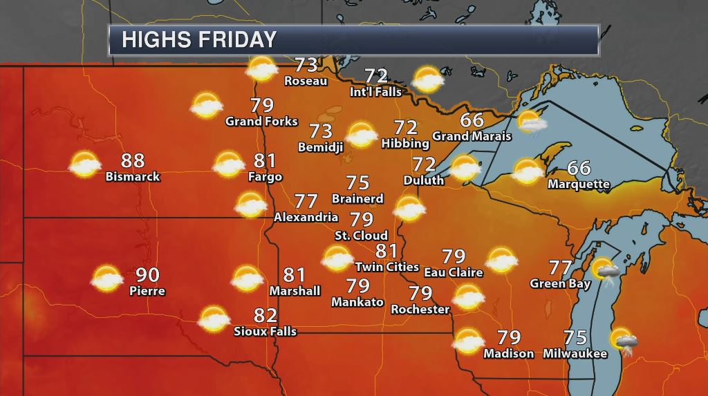
FRIDAY: Not as sticky. Brilliant sunshine. Winds: NW 7-12. High: 81
SATURDAY: Lake worthy. Grab the flip flops. Winds: W 5. Wake-up: 61. High: 83
SUNDAY: More humid. A few late day rumbles? Winds: SSW 10-15 Wake-up: 65. High: 85
MONDAY: Looks dry. Feels like summer. Winds: NNE 5. Wake-up: 66. High: 83
TUESDAY: Sticky sun, few T-storms in the area. Winds: E 5-10. Wake-up: 64. High: 84
WEDNESDAY: Isolated thundery downpours possible. Winds: ESE 5-10. Wake-up: 65. High: 84.
_______________________________________________________
_______________________________________________________
This Day in Weather History
July 6th
July 6th
1936: A high of 104 degrees is recorded at Minneapolis.
________________________________________________________
________________________________________________________
Average High/Low for Minneapolis
July 6th
July 6th
Average High: 84F (Record: 104F set in 1936)
Average Low: 64F (Record: 49F set in 1942)
Average Low: 64F (Record: 49F set in 1942)
Record Rainfall: 2.83" set in 2015
_________________________________________________________
_________________________________________________________
Sunrise/Sunset Times for Minneapolis
July 6th
July 6th
Sunrise: 5:34am
Sunset: 9:01pm
Sunset: 9:01pm
Hours of Daylight: 15hours & 28mins
Daylight LOST since yesterday: ~1 minute and 4 seconds
Daylight LOST since summer solstice (June 20th): ~9 minutes
__________________________________________________________
Daylight LOST since summer solstice (June 20th): ~9 minutes
__________________________________________________________
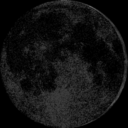
Moon Phase for June 26th at Midnight
2.9 Days Until Full "Buck" Moon
2.9 Days Until Full "Buck" Moon
__________________________________________________________________________
Weather Outlook for Thursday
Winds on Thursday will pick up a little across the region as a front pushes through. Note that wind gusts behind the front across the Dakotas and far western Minnesota could exceed 20mph.
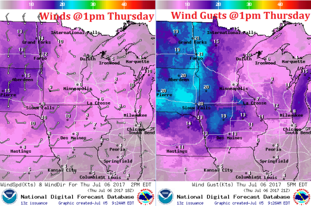
Weather Outlook for Thursday
As the front pushes through the region, widely scattered showers and storms could develop along and east of the Mississippi River into Wisconsin.
__________________________________________________________________________
Extended Rainfall Forecast
Here's the rainfall potential through PM Friday, which suggests heavier rainfall potential across parts of Wisconsin as thunderstorms develop across the region.
Weather Outlook For Thursday
Thursday will be another hot and steamy day with highs approaching 90F or warmer across southern MN. With elevated dewpoints, it could feel more like the mid to upper 90s for some. Temperatures ahead of the front could be 5F to 15F above average across much of the Upper Midwest.
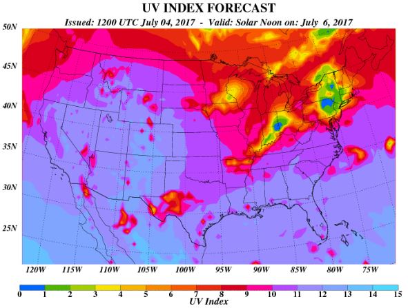
UV Index for Thursday - VERY HIGH
The UV Index will be considered VERY HIGH across much of the state of Minnesota on Thursday, which means that it will only 15 to 20 minutes or less to burn unprotected skin. With that said, if you are planning on spending any extended length of time outside, make sure you wear appropriate attire and lather on the sun block!
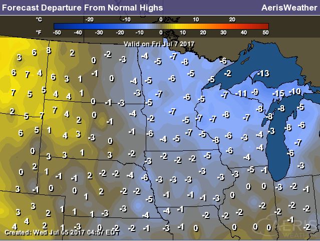
Weather Outlook For Friday
Now that's more like it! High temperatures and humidity values will be quite a bit lower on Friday making for a very nice early July day. Enjoy!
_____________________________________________________________
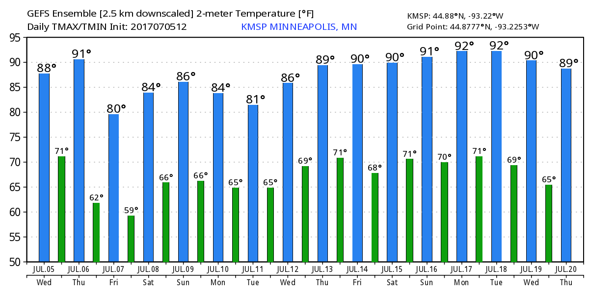
Temperature Outlook
Here's the temperature outlook through July 20th, which suggests flashes of heat taking us through the middle part of the month. After another hot day Thursday, readings will take a dip briefly into early next week before heating up again! It appears that several 90s could be in our future by mid month.
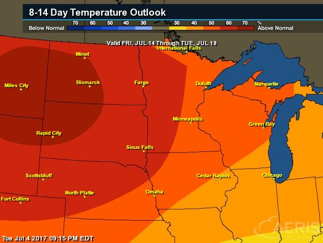
8 to 14 Day Temperature Outlook
According to NOAA's CPC, the extended temperature outlook from July 14th to July 19th suggests warmer than average temperatures moving back into the Upper Midwest.
___________________________________________________________
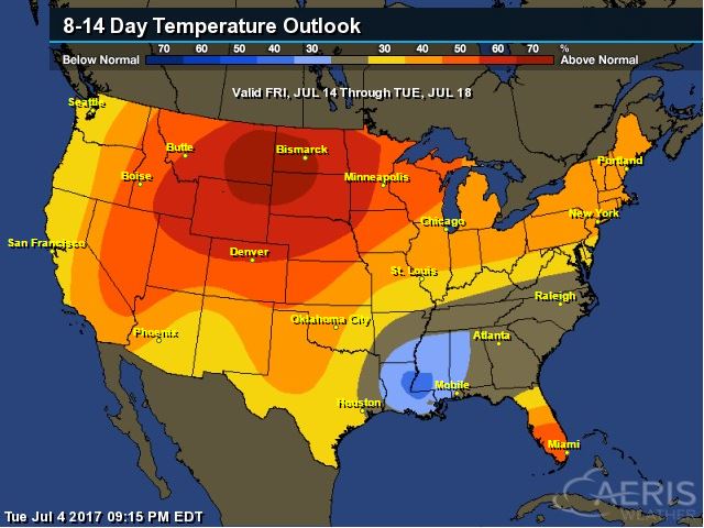
Extended Temperature Outlook
According to NOAA's CPC, the extended temperature outlook through July 18th shows much of the nation will be dealing with above normal temperatures around mid July. The only cool spot maybe located across the Lower Mississippi Valley.
 ____________________________________________________________
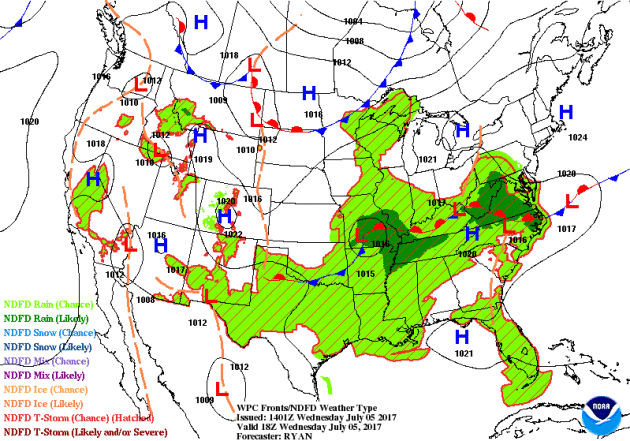
Weather Outlook This Week
The weather outlook over the next couple of days shows stormy weather continuing across the eastern half of the country. Note that some of the storms could be strong to severe with locally heavy rainfall. There will also be spotty storms across the Intermountain West and even some monsoon storms in the Desert Southwest.
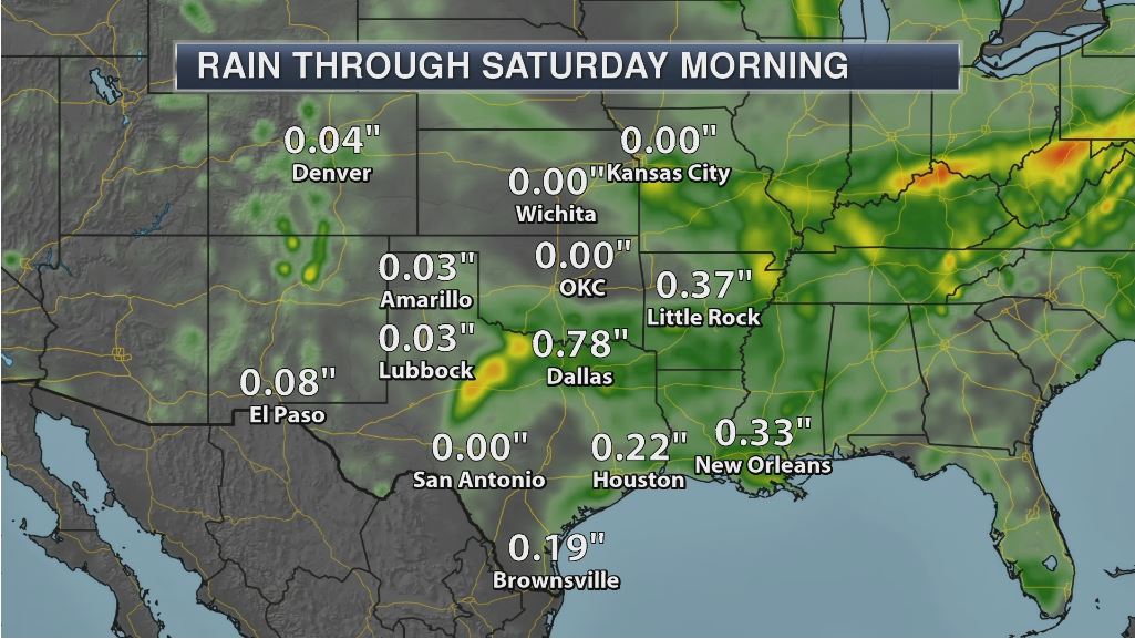
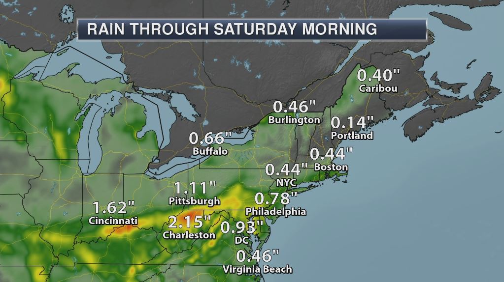
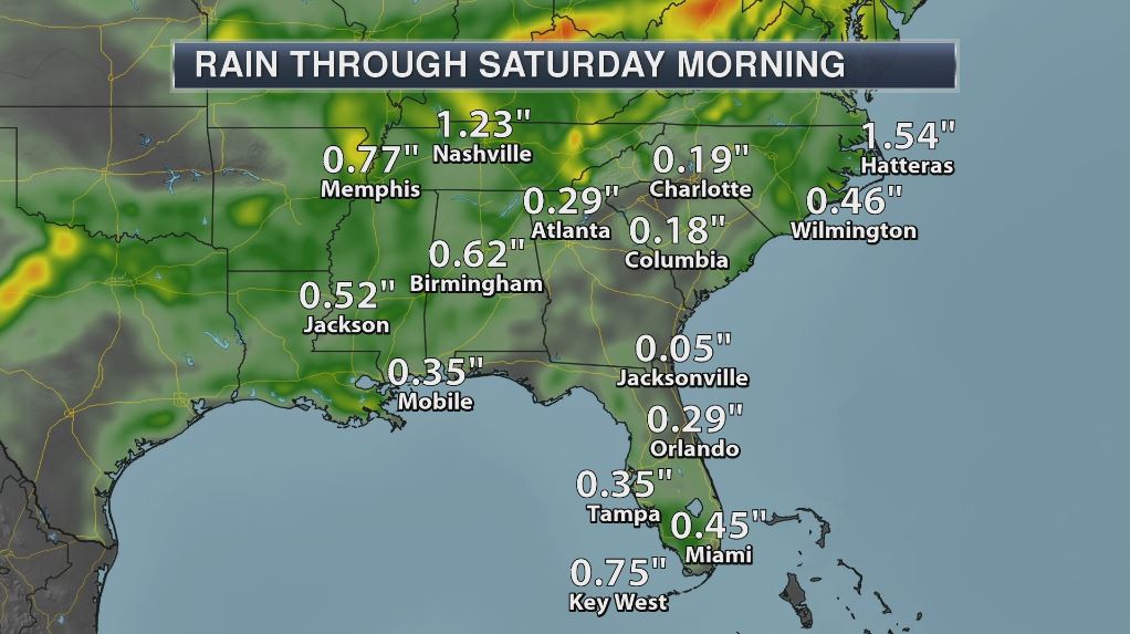
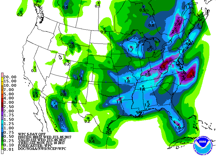
5 Day Precipitation Outlook
According to NOAA's WPC, the next several days could produce areas of locally heavy rainfall across the eastern half of the country. Some locations could see 1" to 3"+, especially across parts of the Ohio Valley into the Mid-Atlantic States and parts of the Northeast. Other than a few heavy downpours across the Intermountain West and monsoonal storms in the Southwest, much of the Western US will remain hot and dry!
___________________________________________________________________
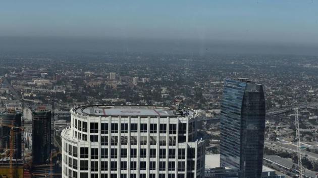
"Air pollution exposure may hasten death, even at levels deemed 'safe,' study says"
"At a time when the Trump administration is moving to delay and dismantle air quality regulations, a new study suggests that air pollution continues to cut Americans’ lives short, even at levels well below the legal limits set by the U.S. Environmental Protection Agency. The nationwide study of more than 60 million senior citizens linked long-term exposure to two main smog pollutants — ozone and fine particulate matter — to an increased risk of premature death."
[Even at levels considered safe by the Environmental Protection Agency, the fine particulates and ozone in air pollution were associated with premature risk of death, according to a new Harvard study. (Allen J. Schaben / Los Angeles Times)]
_________________________________________________________________
"As space junk soars, science turns to nature for ideas"
"Even if we stop launching rockets today, cascading collisions between orbiting objects will continue to endanger satellites. But this sticky problem might have an even stickier solution: gecko-inspired trash grabbers. It was satellites that launched the space age, and it’s satellites that could bring it all crashing down. More than 1,300 circle above our heads, providing navigation signals, studying the planet, and beaming TV to millions. Few communications pass directly through space networks, but if not for the nearly three dozen atomic clocks providing reliably precise timestamps to anyone with an antenna, financial markets and cell service would quickly fall apart."
(Image courtesy: Orbital Debris Program Office/NASA)

________________________________________________________________
"Harsh winter took heavy toll on wildlife across the western U.S."
Mule deer in several Rocky Mountain states and elk in eastern Washington were hit hard. Wildlife suffered higher than normal losses this winter in severe weather across the western United States, where the toll included the deaths of all known fawns in one Wyoming deer herd and dozens of endangered bighorn sheep in California. Wildlife managers in Colorado, Utah, Idaho, Oregon and Washington also reported higher losses of animals in the wake of one of the coldest and snowiest winters in decades. Parts of the Rockies saw snowfall as late as mid-June. “This year we kind of had all the factors that we don’t want — we had deep snow, we had periods of fairly cold weather, subzero, and then we also had some crusting on top of that snow,” said Roger Phillips, spokesman for the Idaho Fish and Game Department. Wildlife managers have been assessing the damage using radio collars and surveys of herds following a winter in which many parts of the West recorded record snowfall, including places where deer, pronghorn antelope and elk migrate each fall to escape the harsher mountain winters. Prolonged snow cover on winter grounds made it difficult for wildlife to find food, and spells of bitter cold made matters worse for the weakened animals by hardening the snow.
(In this Jan. 18, 2017, file photo provided by the Oregon Department of Fish and Wildlife, elk feed at the Wenaha Wildlife Area near Troy, Ore. Wildlife managers in seven states in the U.S. West, including Oregon, report severe weather this past winter was rough on wildlife.)

____________________________________________________________
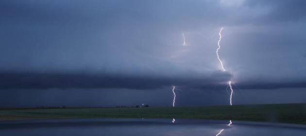
"Surviving a lightning strike"
Sometimes they'll keep the clothing, the strips of shirt or trousers that weren't cut away and discarded by the doctors. They'll tell and retell their story at family gatherings and online, sharing pictures and news reports of survivals like their own or far bigger tragedies. The tourist hit on a Brazilian beach. The Texan struck dead while out running. The 65 people killed during four stormy days in Bangladesh. Only by piecing together the bystander reports, the singed clothing, and the burnt skin can survivors start to construct their own picture of the possible trajectory of the electrical current, one that can approach 200 million volts and travel at one-third the speed of light. In this way, Jaime Santana's family has stitched together some of what happened that Saturday afternoon in April 2016, through his injuries, burnt clothing, and, most of all, his shredded broad-brimmed straw hat. Jaime had been horse riding with his brother-in-law and two others in the mountains behind his brother-in-law's home outside Phoenix. Dark clouds had formed, heading in their direction, so the group had started back.
(Image courtesy The Week)
_____________________________________________________________________
"Global warming tipped scales in Europe’s heat wave"
Global warming gave a clear boost to the searing temperatures that blanketed Western Europe earlier this month — a heat wave that helped fuel deadly wildfires in Portugal. The greenhouse gas-driven warming of the atmosphere has made the intensity and frequency of such extreme heat up to 10 times as likely, according to a new analysis from researchers working with Climate Central’s World Weather Attribution program and several outside partners. It is the latest such attribution analysis to show that the warming that has occurred over the last century — nearly 2°F (1°C) — has already had a clear influence on such extreme heat events. “Global warming has already put a thumb on the scales; it’s already tipped the odds,” Noah Diffenbaugh, a Stanford University climate scientist who wasn’t involved with the work, said.
____________________________________________________________________
Thanks for checking in and don't forget to follow me on Twitter @TNelsonWX

No comments:
Post a Comment