67 F. average high on September 26.
66 F. high on September 26, 2016.
September 27, 1942: Minneapolis has a high temperature of only 40 degrees.
September 27, 1898: A heat wave produces highs of 91 degrees at Beardsley and 90 at Moorhead.
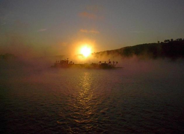
A Little Fog - A Little Sun - Relatively Quiet
"We know that in September, we will wander through the warm winds of summer's wreckage. We will welcome summer's ghost" wrote Heny Rollins. I love a good Minnesota summer. Even the bad ones are worth savoring, but there's something about our increasingly super-sized autumns that rubs people the right way.
It's almost as if Mother Nature scheduled a reluctant intermission, sandwiched between raging thunderstorms and snowy clippers to come.
Our latest stormy swirl is long gone, with sunshine the rule into Saturday. Most of us won't see rain until Sunday, when the next frontal boundary arrives with showers and thundershowers. ECMWF (European) guidance shows another run of 80s by the middle of next week. I don't think the metro area will enjoy another 100F heat index this year, but more shorts-worthy warmth is likely as we push into October.
September is prime time for lazy clouds, or fog, resulting from long nights and lingering moisture in the atmosphere - most likely after a sloppy front.
That's about as exciting as our weather will get anytime soon. I'm OK with that.
"Hysteria is Starting to Spread": Puerto Rico is Devastated in the Wake of Hurricane Maria. Vox has the harrowing details: "...Hysteria is starting to spread,” Jose Sanchez Gonzalez, mayor of Manati, a town on the North shore, told
the Associated Press. “The hospital is about to collapse. It’s at
capacity. … We need someone to help us immediately.” But the list of
woes is much longer. An untold number of homes are irreparably damaged.
Infrastructure is badly damaged. People aren’t working. The storm was
particularly costly for the agriculture industry: “In a matter of hours,
Hurricane Maria wiped out about 80 percent of the crop value in Puerto
Rico,” the New York Times reports. Even the National Weather Services Doppler weather radar station on the island has been destroyed.
That’s the radar that helps meteorologist see where thunderstorms and
other weather systems are moving in real time. “Not having radar does
make future storms more hazardous,” says Jeff Weber, a meteorologist
with the National Center for Atmospheric Research..."
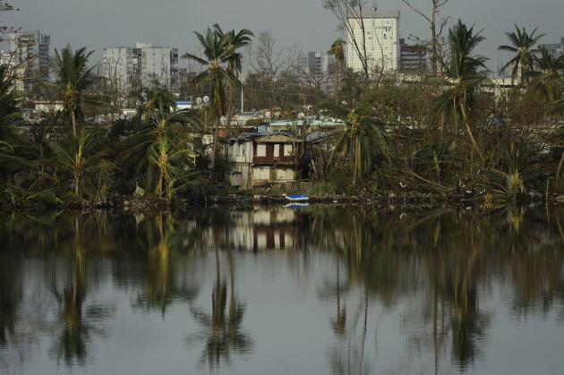
Photo credit: "Trees are reflected in the water in the Buena Vista community, in the aftermath of Hurricane Maria in San Juan." Carlos Giusti / AP.
Praedictix Briefing: Issued Tuesday, September 26th, 2017:
*Maria continues to cling on to hurricane strength this morning, with sustained winds of 75 mph. Maria continues to be a large system with tropical storm force winds extending outward 240 miles from the center.
*Maria will continue to parallel the U.S. coast over the next 24-48 hours before getting quickly nudged east away from the mainland. The forecast path also takes Maria far north of Bermuda.
*While the core of Maria will remain offshore, tropical storm force winds are still expected due to the wide wind swath of this storm. Wind gusts of 55 mph will be possible through Wednesday for areas under a Tropical Storm Warning, which includes Bogue Inlet to the North Carolina/Virginia border including Albemarle and Pamlico Sounds.
*A storm surge of 2-4 feet will also be possible at high tide, especially along the sound side of the Outer Banks. Due to this, a Storm Surge Watch is in effect for Cape Lookout to Duck.
*High surf and the threat of rip currents will continue along the East Coast this week due to Maria. Rainfall amounts from this system are expected to be light, with 1-2” possible for the Outer Banks.
 Maria This Morning.
Maria continues to hold on to hurricane strength this morning, even
though the system is being affected by cooler waters and some upper
level winds. As of 8 AM ET, Maria was sitting 190 miles southeast of Cape Hatteras, NC, and moving north at 7 mph.
 Official Maria Track.
A steady (and somewhat slow) northward movement is expected over the
next 24-48 hours as Maria continues to parallel the U.S. East Coast. As
it does so, it would make its closest approach to the coast - although
still far offshore - into Wednesday. Maria is also expected to weaken into a tropical storm during this period. By Thursday, Maria should receive a shove off to the east, and the forward motion of the system will rapidly increase.
 Timing Tropical Storm Force Winds.
Conditions will start to deteriorate today across portions of the
Mid-Atlantic Coast, including in the Outer Banks as tropical storm force
winds arrive.
 Wind Gusts Up To 55 MPH.
The strongest wind gusts are expected along the Outer Banks with Maria,
where winds could gust over 50 mph. Some of the strongest wind gusts
for places like Hatteras and Kill Devil Hills will occur tonight.
 Tropical Storm Warnings.
Due to mainly the wind threat from Maria, Tropical Storm Warnings have
been issued for parts of North Carolina, including the Outer Banks.
Along the coast, these warnings include the following locations:
* Bogue Inlet to the North Carolina/Virginia border
* Albemarle and Pamlico Sounds
 Storm Surge Potential.
The large wind field will help to produce the potential of coastal
flooding from storm surge, especially along the sound side of the Outer
Banks. A storm surge of 2-4 feet will be possible - mainly at high tide -
over multiple tide cycles.
 Storm Surge Watch. Due to the potential of storm surge flooding, a Storm Surge Watch has been issued for the following coastal locations:
* Cape Lookout to Duck
Summary: While Maria will continue to pass far offshore the U.S. East Coast through the middle of the week, some tropical storm impacts from this large system will be felt in far eastern North Carolina, including the Outer Banks. Winds will gust over 50 mph at times, especially in the Outer Banks, with sustained tropical storm force winds expected. Due to this wind threat, Tropical Storm Warnings are in effect from Bogue Inlet to the North Carolina/Virginia border including Albemarle and Pamlico Sounds. Storm surge flooding of 2-4 feet - especially at high tide - can be expected along the coast, especially on the sound side of the Outer Banks. Maria will continue to move north over the next 1-2 days before getting a quick push off to the east.
Meteorologist D.J. Kayser, Praedictix
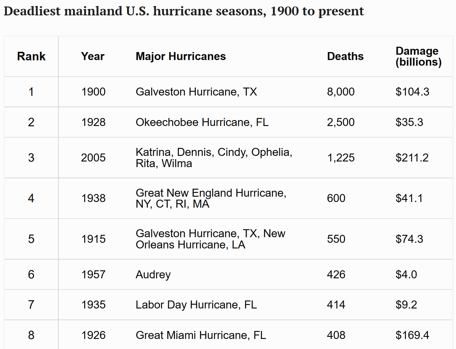
Is This the Worst Hurricane Season Ever? Here's How it Compares. Relatives of people who died in the great Galveston Hurricane of 1900 might beg to differ. Details via TIME.com: "The deadliest natural disaster in U.S. history is also the most fatal hurricane to date. In 1900, inaccurate predictions, combined with poor warning systems, left Galveston, Texas vulnerable to a hurricane that killed between 6,000 and 12,000 people. Twenty-eight years later, an estimated 2,500 people drowned when a Category 4 hurricane caused Lake Okeechobee in Florida to overflow, deluging the surrounding area with 10-to-15-foot floods. The 10 deadliest hurricane seasons include only one from within the past 50 years: 2005, when Hurricane Katrina overwhelmed the levees in New Orleans and inundated the city, killing more than 1,000 people..."
*Maria continues to cling on to hurricane strength this morning, with sustained winds of 75 mph. Maria continues to be a large system with tropical storm force winds extending outward 240 miles from the center.
*Maria will continue to parallel the U.S. coast over the next 24-48 hours before getting quickly nudged east away from the mainland. The forecast path also takes Maria far north of Bermuda.
*While the core of Maria will remain offshore, tropical storm force winds are still expected due to the wide wind swath of this storm. Wind gusts of 55 mph will be possible through Wednesday for areas under a Tropical Storm Warning, which includes Bogue Inlet to the North Carolina/Virginia border including Albemarle and Pamlico Sounds.
*A storm surge of 2-4 feet will also be possible at high tide, especially along the sound side of the Outer Banks. Due to this, a Storm Surge Watch is in effect for Cape Lookout to Duck.
*High surf and the threat of rip currents will continue along the East Coast this week due to Maria. Rainfall amounts from this system are expected to be light, with 1-2” possible for the Outer Banks.


* Bogue Inlet to the North Carolina/Virginia border
* Albemarle and Pamlico Sounds


* Cape Lookout to Duck
Summary: While Maria will continue to pass far offshore the U.S. East Coast through the middle of the week, some tropical storm impacts from this large system will be felt in far eastern North Carolina, including the Outer Banks. Winds will gust over 50 mph at times, especially in the Outer Banks, with sustained tropical storm force winds expected. Due to this wind threat, Tropical Storm Warnings are in effect from Bogue Inlet to the North Carolina/Virginia border including Albemarle and Pamlico Sounds. Storm surge flooding of 2-4 feet - especially at high tide - can be expected along the coast, especially on the sound side of the Outer Banks. Maria will continue to move north over the next 1-2 days before getting a quick push off to the east.
Meteorologist D.J. Kayser, Praedictix
Is This the Worst Hurricane Season Ever? Here's How it Compares. Relatives of people who died in the great Galveston Hurricane of 1900 might beg to differ. Details via TIME.com: "The deadliest natural disaster in U.S. history is also the most fatal hurricane to date. In 1900, inaccurate predictions, combined with poor warning systems, left Galveston, Texas vulnerable to a hurricane that killed between 6,000 and 12,000 people. Twenty-eight years later, an estimated 2,500 people drowned when a Category 4 hurricane caused Lake Okeechobee in Florida to overflow, deluging the surrounding area with 10-to-15-foot floods. The 10 deadliest hurricane seasons include only one from within the past 50 years: 2005, when Hurricane Katrina overwhelmed the levees in New Orleans and inundated the city, killing more than 1,000 people..."
Puerto Rico's Devastation Grows: Climate Nexus reports: "Puerto Rico's humanitarian crisis continued to grow over the weekend, as officials describe "apocalyptic" conditions across the island in the wake of Hurricane Maria. Many of the 3.4 American citizens living on the island are without power and disconnected from communications, and officials estimate some areas won't see power restored for months. Isolated towns and low-income communities are facing increasing shortages of supplies and fuel. Officials estimate the storm also destroyed around 80 percent of the island's crop value, while a dam compromised by heavy rain is causing worries about flooding and accessibility of drinking water. "The devastation in Puerto Rico has set us back nearly 20 to 30 years," Jenniffer Gonzalez, the island's nonvoting representative in Congress, told the AP." (Conditions: CNN, AP, Washington Post $, Bloomberg, New York Times $. Communications & power: NPR, Vox, NBC. Agriculture: New York Times $. Dam: New York Times $, Reuters, NBC, USA Today, CNN. Commentary: New York Times editorial $)
- United for Puerto Rico (spearheaded by the First Lady of Puerto Rico)
- UNICEF
- Center for Popular Democracy
- Hispanic Federation’s “Unidos” page
- Former U.S. presidents have expanded their One America Appeal to include recovery efforts in Puerto Rico and the U.S. Virgin Islands
- All Hands Volunteers
- Catholic Relief Services
- Americares
- Direct Relief
- Save the Children, which focuses specifically on the needs of families and their children.
- Global Giving has a $2 million goal for victims of Hurricane Maria..."
Harvey is Scaring Houston Straight on Flood Safety, But Dallas May Take Longer. The Dallas Observer has some interesting perspective on flood risk in Dallas: "...We have the same system, only more dangerous. If only one of our immense regional reservoirs fails, the toll in human lives would be staggering. As a special project in The Dallas Morning News by George Getschow revealed two years ago, a failure of the aged and decaying Lake Lewisville Dam would put 431,000 lives in immediate jeopardy. An upstream dam failure at any of the three major reservoirs that flow directly into downtown Dallas must be stacked against the old and rickety system of flood safety levees along the Trinity River through downtown. In 2009, the Corps of Engineers rated that entire levee system as “unacceptable,” the most stupidly abused term in contemporary public double-speak. What they really meant was, “no good,” “unsafe,” “won’t do the job,” “grab your water-wings and paddle as fast as you can...”
Photo credit: "Harvey taught Houston that the things it had been told before about flood safety simply were not true." U.S. Army photo by 1st Lt. Zachary West.
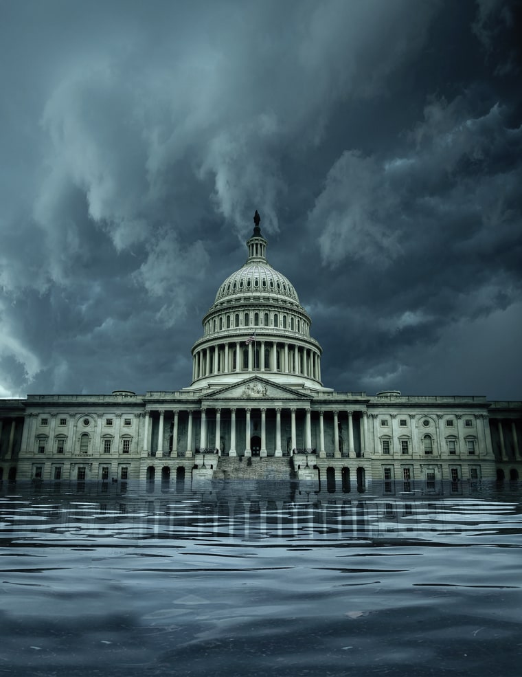
What Happens When a Superstorm Hits D.C.? Rolling Stone takes a look at a worst-case scenario for Washington D.C.: "...For scientists like Resio, a big concern is if a storm system in the mountains unfolds just before a major hurricane hits near the Outer Banks of North Carolina, then tracks inland, pulling a small mountain of water up the Chesapeake, then up the Potomac. This happened in the Chesapeake-Potomac Hurricane of 1933, which carried a deadly 11-foot storm surge; with Hurricane Hazel in 1954; Hurricane Connie in 1955; and Hurricane Isabel, a Category 2 storm that hit in 2003 with a nearly nine-foot surge that severed power at two of Maryland's largest sewage treatment plants, sending 96 million gallons of sewage flowing toward D.C. "Isabel is a reminder," wrote David L. Johnson, then assistant administrator for Weather Services, in a government assessment of the storm, "that if the impact of a Category 2 hurricane can be so extensive, then the impact of a major hurricane (Category 3 or higher) could be devastating..."
Illustration credit: John Blackford for Rolling Stone. Photograph used in illustration by Ryan D. Budhu.
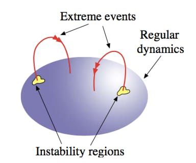
M.I.T. Scientists Use Math to Predict the Next Great Hurricane. Yahoo News has an interesting post: "We
are looking at the equations for possible states that have very high
growth rates and become extreme events, but they are also consistent
with data, telling us whether this state has any likelihood of
occurring, or if it’s something so exotic that, yes, it will lead to an
extreme event, but the probability of it occurring is basically zero,”
Sapsis says. Their algorithm isn’t perfect yet, but the researchers hope
that their research will help scientists around the world come up with
ways to predict and even suppress the kinds of turbulence that can lead
to extreme events. At the current rate we’re experiencing extreme
weather events, every little bit helps..."
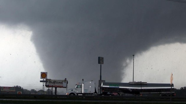
Why Do We Ignore Warnings? Here's a post that caught my eye: "In
2012, two professors from the University of Buffalo School of
Management studied why people failed to heed disaster warnings. Dr. Raj
Sharman and H. Raghav Rao examined a number of post-disaster reports to
assess why some people refused to evacuate in the face of warnings
about imminent tornadoes, hurricanes and other emergency situations such
as campus shootings and industrial accidents. The reports were
conducted by organizations including the National Weather Service,
National Oceanic and Atmospheric Administration and the Congressional
Research Service.
The researchers
found that past personal experience in “riding out” storms can lead
people to feel complacent when receiving emergency warnings. On the
other hand, previous warnings that proved to be false can result in
apathetic responses when another warning occurs. Post-disaster surveys
also showed that many people lacked awareness about how serious the
situation was when warnings happened.
To
combat the factors leading to non-response, the researchers made three
recommendations. First, warnings should come from more than one source.
“Generally speaking, a single source of information rarely prompts
people to take appropriate action,” Sharman said. “Multiple sources are
more effective.” Second, warnings should include more descriptive
language, using words such as “unsurvivable” and “catastrophic” and
urging citizens to take “immediate, life-saving action” to motivate the
public in the event of imminent and extreme severe weather. Finally,
communities should take advantage of technological advances to make
warnings more specific. Technology may help motivate people to take
action because they can see the threat to themselves." (source: Peter Kennedy's Daily Devotionals).
What Would An Entirely Flood-Proof City Look Like? The Guardian imagines how cities may be forced to reinvent themselves in the years ahead: "They call it “pave, pipe, and pump”: the mentality that has dominated urban development for over a century. Along with the explosion of the motorcar in the early 20th century came paved surfaces. Rainwater – instead of being sucked up by plants, evaporating, or filtering through the ground back to rivers and lakes – was suddenly forced to slide over pavements and roads into drains, pipes and sewers. Their maximum capacities are based on scenarios such as 10-year storms. And once they clog, the water – with nowhere else to go – simply rises. The reality of climate change and more frequent and intense downpours has exposed the hubris of this approach. As the recent floods from Bangladesh to Texas show, it’s not just the unprecedented magnitude of storms that can cause disaster: it’s urbanisation..."
File photo credit: Jordan Anderson, DoubleHorn Photography.
Upper Air Observations: How Weather Balloons Improve Forecasts. Satellites derive wind, moisture and temperature - with weather balloons you get real measurements of the atmosphere in real-time. NOAA explains: "...The radiosondes allow the direct measurement of the upper atmosphere as opposed to the indirect remote sensing techniques employed by satellites or ground-based remote sensing instrumentation. As a result, these observational data are more accurate and reliable than indirect data types. The combination of the two allows for the best forecasts, ensuring public safety in the event of an approaching storm. “Models initialized with good data can provide better and more certain forecast information,” said Aberson. “When the forecast is difficult or different models disagree, more frequent radiosonde observations are requested. This is likely to improve how accurate the forecasts are.”
Photo credit: Latonja Martin "In
a test, SM-6 missiles fired from the guided-missile destroyer USS John
Paul Jones (DDG 53) hit a target medium-range ballistic missile off
Hawaii, Au. 29, 2017."
"Disruption" is How Silicon Valley Eats Its Young. The treadmill of change is moving ever-faster; a story at WIRED.com caught my eye: "...The
fact is, most businesses are very unlikely to “disrupt” anything any
time soon—if ever. It takes years, if not decades, to know whether a new
service, product, or piece of technology is really
going to upend an industry or a process, despite founders' claims to
the contrary. Yet promises of earth-shattering changes make an
appearance from the get-go, in the pitch deck or launching blog post.
Magic words seem to apply to all kinds of companies and products, be
they multinational or garage-based.So why venture out onto that clichéd
limb? Probably because we in the audience (readers, viewers, consumers,
and shareholders) have been privy to a remarkable amount of genuine
disruption in the last 10 years. In just this period we’ve witnessed the
upending of retail, music, newspapers, mobile phones, advertising, TV,
and even more. So now, when a company claims it will disrupt an entire
industry, we’re primed to believe them..."
10 Alarming Triggers for Alzheimer's Disease. ActiveBeat takes a look at some of possible precursors: "Danish
researchers found a link between Alzheimer’s and rosacea, the chronic
inflammatory skin disorder in elderly patients. Rosacea produces higher
levels of matrix metalloproteinases and antimicrobial peptide proteins
that are responsible for brain-wasting disorders. The study printed in
the Annals of Neurology concluded that patients with Rosacea had a 7%
higher risk of Alzheimer’s. Out of those people, women with rosacea were
28% more likely to develop Alzheimer’s, where men were only 16% more
likely to develop Alzheimer’s..."
The Shorter You Sleep, The Shorter Your Life: The New Sleep Science. The Guardian has a sobering, but important story: "...Why,
exactly, are we so sleep-deprived? What has happened over the course of
the last 75 years? In 1942, less than 8% of the population was trying
to survive on six hours or less sleep a night; in 2017, almost one in
two people is. The reasons are seemingly obvious. “First, we electrified
the night,” Walker says. “Light is a profound degrader of our sleep.
Second, there is the issue of work: not only the porous borders between
when you start and finish, but longer commuter times, too. No one wants
to give up time with their family or entertainment, so they give up
sleep instead. And anxiety plays a part. We’re a lonelier, more
depressed society. Alcohol and caffeine are more widely available. All
these are the enemies of sleep...”
Dutch Cyclist Who Broke Her Back in Horrific Rio Olympics Crash Returns to Win World Gold. I needed this story at The Washington Post: "Annemiek
van Vleuten’s teammates thought she had died last summer when the Dutch
cyclist smashed headfirst into the pavement during a downhill stretch
of the women’s road race at the Rio Olympics. Van Vleuten, who sustained
a concussion and broke three vertebrae in her back, vowed to come back
and, even better, to win. While the 34-year-old will have to wait until
2020 to get another shot at an Olympic gold, van Vleuten only had to
wait just more than a year to earn her first world gold. On Tuesday, she
took the time trial in Bergen, Norway, finishing the 13-mile course in
28 minutes 50.35 seconds, 12 seconds ahead of fellow Dutchwoman Anna ven
der Breggen, who won gold in Brazil. With tears in her eyes, van
Vleuten addressed the crash after Tuesday’s win, which she called
“incredible...”
Photo credit: Sky Sports.
Wal-Mart Wants to Send People Into Your House to Stock the Fridge When You're Not Home. I mean, what can possibly go wrong? Here's an excerpt from The Los Angeles Times: "Delivery
workers who drop off Wal-Mart groceries may soon also bring them into
your kitchen and unload them into your refrigerator, even if you're not
home. The world's largest retailer announced Friday that is testing a
delivery program in Silicon Valley that would allow customers to use
smart-home technology to remotely open the door for delivery workers and
watch a livestream of the delivery by linking their phones with home
security cameras. Bentonville, Ark.-based Wal-Mart said the in-home
delivery service is aimed at busy families that don't have time to stop
at a store or unpack their groceries..."
Google Taps Levi's to Create Interactive Jeans. I didn't even realize I needed interactive jeans. Quartz explains: "...Conductive fabric has been around for decades,
but this partnership with Google will represent one of the first major
forays for the technology into the mass market. Neither company has
revealed details on exactly what product they’ll make, (though jeans
seem the most likely candidate), what the high-tech clothing will be
able to do, or when it will be released. However, like the Apple Watch
and Google Glass, the goal of connected jeans, they say, is to aid
people in their daily lives, without making the technology overbearing..."
“That to which your heart clings is your god.” – Martin Luther

TODAY: Comfortable sunshine. Winds: NW 7-12. High: 65
WEDNESDAY NIGHT: Mostly clear, patches of fog. Low: 51
THURSDAY: Mild sun, stray late-day T-shower possible. Winds: W 5-10. High: 70
FRIDAY: Plenty of blue sky, few complaints. Winds: NE 5-10. Wake-up: 49. High: 67
SATURDAY: Intervals of sun, nicer day of weekend. Winds: SE 5-10. Wake-up: 47. High: 69
SUNDAY: Showers likely, possible T-showers. Winds: S 10-15. Wake-up: 55. High: 63
MONDAY: Showers taper, PM clearing. Winds: W 7-12. Wake-up: 53. High: near 70
TUESDAY: Partly sunny, summer in October. Winds: S 10-15. Wake-up: 56. High: 82
Climate Stories...

- Seattle, Washington
- Philadelphia, Pennsylvania
- Austin, Texas
- Phoenix, Arizona
- Baltimore, Maryland
- Portland, Oregon
- San Francisco, California
- Minneapolis, Minnesota
- Ann Arbor, Michigan
- Madison, Wisconsin
- Chicago, Illinois..."
Birding: To Cope with Climate Change, Birds Need More Time. A story at Cape Cod Times caught my eye: "...As Dr. Charles “Stormy Mayo, senior scientist at the Center for Coastal Studies in Provincetown, announced in a radio interview in August, “Changes in weather occurred over millennia, thousands of years — birds, mammals, plants and insects could evolve and deal with this slow environmental change — but climate change today happens faster, in some cases less than 10 years.” Bird behavior and bird environment are becoming mismatched: much of a bird’s life cycle and behavior is closely linked to changing seasons. A mismatch occurs when birds cannot shift their behavior in time to coincide with changes in environment, when food is most available for young and adults. Bird behavior is activated by photoperiodism; plants and insects respond to temperatures. One large-scale study has showed that most birds are laying eggs at an average rate of almost seven days earlier compared to 10 years ago..."
Hurricanes: A Perfect Storm of Chance and Climate Change. Of
course natural variability plays a (huge) role, but are [consistently
warmer/deeper] ocean water temperatures priming the pump for more
intense hurricanes? Here's a clip from BBC News: "...Most
researchers who study extreme events like hurricanes agree that climate
change is most likely making the impacts of these events much worse.
Rising temperatures lead to warmer air holding more moisture, which
causes more intense downpours in a hurricane. The oceans have risen
thanks to thermal expansion and glacier melt and this works to increase
the dangers posed by storm surges. "In terms of the factors that control
the genesis and the intensification of these hurricanes, a number of
these point to the fact that they will undoubtedly be slightly more
severe due to the extra heat content in the ocean due to the long-term
warming of the climate," said Richard Allan..."
Hurricane Maria file image from Sunday morning, September 24, 2017, courtesy of AerisWeather.
"Eden is Broken": A Caribbean Leader Spotlights Climate Change. Here's an excerpt from The New Yorker: "...Since
hurricanes began to be recorded and classified, in 1851, thirty-three
storms have reached Category 5 strength in the Atlantic, according to
Michael Lowry, a visiting scientist at the University Corporation for
Atmospheric Research, in Boulder, Colorado. Two of those tore through
the Caribbean within the last two weeks. Data compiled by Weather
Underground shows that in only twelve hours Hurricane Maria strengthened
from a Category 2 hurricane to a Category 5. When the storm made
landfall in Dominica, on Monday, it unleashed
a-hundred-and-seventy-five-mile-per-hour winds on the island of seventy
thousand people.When the sun rose on Tuesday morning, swaths of the
island’s two hundred and ninety square miles looked like a war zone,
Skerrit said. Eighty-five to ninety per cent of homes on the island were
damaged, as was the main hospital, which lost its roof and is still
without electricity..."
Photo credit: Saptak Ganguly.
In Canada, Climate Change Could Open New Farmland to the Plow. A story at Reuters highlights the trends: "As
global warming intensifies droughts and floods, causing crop failures
in many parts of the world, Canada may see something different: a
farming expansion. Rising temperatures could open millions of once
frigid acres to the plow, officials, farmers and scientists predict.
“Canada is one of the few countries where climate change may create some
opportunities for growing crops in northern latitudes,” said Rod
Bonnett, president of the Canadian Federation of Agriculture, a lobby
group representing 200,000 farmers. But determining just how much land
in the world’s second largest country could become suitable for farming
as a result of climate change is not easy, said Ian Jarvis, a senior
official with Agriculture and Agri-Food Canada, a government department..." (File photo: Climate Reality).
Continued Denial Leaves Florida in Climate Change Crosshairs. An Op-Ed from the Editorial Board at Florida's Sun-Sentinel pulls no punches: "...Trump, who has called global warming a Chinese hoax, chose a notorious climate change denier, Scott Pruitt,
to run the EPA. It would be hard to find a more banal remark than
Pruitt's statement that Irma was no time to talk about climate change.
"To use time and effort to address it at this point is very, very
insensitive to the people of Florida," Pruitt said. No, what's
insensitive to the people of Florida is his denial of climate science.
Whitman responded to the news that Pruitt has appointed a "red team" of
dissenting scientists to challenge the vast climate change consensus of
thousands of others. She called it a "slow-rolling catastrophe in the
making." People today increasingly feel free to believe whatever suits
them and there are still some who believe the world is flat, the moon
landings were faked and smoking doesn't cause cancer. But there is no
excuse for so-called leaders to exploit such gullibility..."
Photo credit: "Just
keep going forward, keep helping," says Robert Barnes in Duck Key.
Barnes has been helping clean up his neighborhood after Hurricane Irma
tore through the Florida Keys."
No comments:
Post a Comment