51 F. average high for October 31.
50 F. high on October 31, 2013
8.2" snow on October 31, 1991 as the Halloween Blizzard started up.
October 31 in Minnesota Weather History. Source: Twin Cities National Weather Service:
2000: An F1 tornado touched down on a farm east of Prinsburg in Kandiyohi County destroying a small storage shed. It also tipped another shed on its side, and ripped off a portion of the roof of a third shed.
1999: High winds were reported in central Minnesota. The St. Cloud State University Meteorology Department in Stearns county recorded a 65 mph gust. Morris AWOS in Stevens county, posted a 62 mph gust and Willmar AWOS in Kandiyohi county recorded a 59 mph gust. Area wide sustained winds of 40 mph occurred, with gusts in the 45 to 50 mph range.
1991: Classes were canceled across the state due to the Halloween Blizzard. Three foot drifts across I-94 from the Twin Cities to St. Cloud.
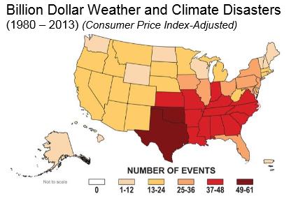
Cool Perspective
Yes, our cold fronts can be annoying, but Minnesota has an abundance of fresh water, no hurricanes, volcanoes or earthquakes to worry about, and far fewer billion dollar disasters than the southern USA.
According to the World Meteorological Organization weather, climate and water-related disasters are on the rise worldwide. From 1970 to 2012 the WMO counted 8,835 disasters, 1.94 million deaths and U.S. $2.4 trillion in losses from cyclones, floods, droughts, temperature extremes and related health epidemics. Those who have the least are most vulnerable to this new level of volatility we're witnessing, worldwide.
No weather drama close to home anytime soon, just a windy weekend after an early morning freeze. Weak frontal passages kick up a few light (rain) showers Monday and Wednesday. Halloween was about as chilly as it's going to get looking out into next week. ECMWF (European) guidance is hinting at 4-5 days above 50F next week. I'm betting on at least one more day above 60F.
It's November and it has yet to snow in the Twin Cities. Last year the first flakes arrived October 19. No snow for deer tracking next weekend, but a stronger cold front arrives in roughly 10 days.
* Graphic above: NOAA NCDC.
** Rising November wildfire risk across Minnesota? Details at The Star Tribune.
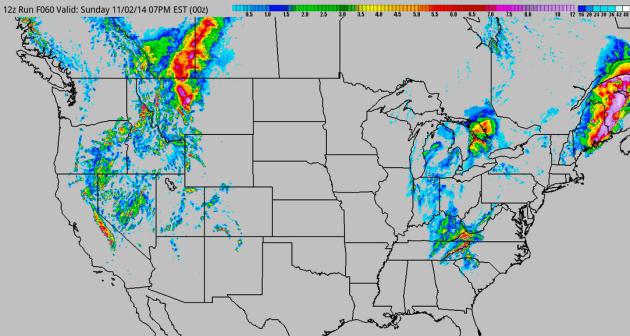
Snow! Or Not. Why Snow Is Hard To Forecast. Climate Central
takes a look at some of the variables that go into snow predictions, in
light of the close call with a nor'easter this weekend along the East
Coast. Here's a clip: "...Some
of this has do to inherent limitations. Models are run using current
atmospheric conditions, gathered by sampling efforts like weather balloons
launched from NWS offices to see what’s happening in the atmosphere at a
certain time. But those sampling efforts don’t cover the whole planet,
and the Earth’s atmosphere is a large, interacting system — what’s
happening on the West Coast today will affect the East Coast a few days
later, for example.
“If we could sample the entire globe perfectly, we’d have a perfect
forecast,” Oraveck said. But meteorologists can’t do that, so they’re
left with the imperfect simulations they can get..."
* 60-hour accumulated snowfall prediction courtesy of NOAA and HAMweather.

Top Allergy Cities in America? Dr. Mark Seeley included this interesting nugget in his weekly Minnesota Weathertalk Newsletter; here's an excerpt: "... The
top three allergy cities in America this autumn season are Louisville,
KY (score 100), Wichita, KS (score 95.76), and Oklahoma City, OK (score
92.00). Minneapolis ranks 35th this autumn with a score of just 66.96.
Last year Minneapolis ranked 37th highest. Among upper Midwestern cities
this autumn, both Des Moines, IA and Madison, WI have higher scores
than Minneapolis. So I guess we should feel good about that..."
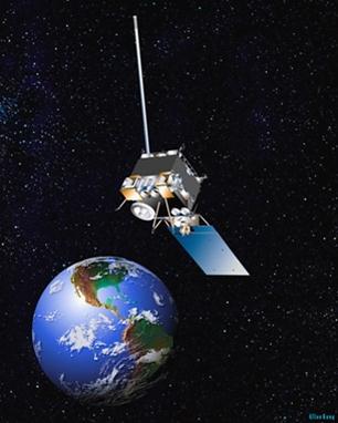
Our Failing Weather Infrastructure.
Something to truly worry about, or just part of the challenge of
running a big weather service with a lot of moving parts? Here's the
intro to an Op-Ed at The New York Times: "Last week the National Weather Service’s
satellite network crashed, leaving forecasters without crucial data as a
large nor’easter swirled across the East Coast, dumping record levels
of rain and leaving thousands of residents without power.This network
shutdown was the latest in a string of failures that has left the agency
unable to meet the needs of the nation. Earlier this year, the
service’s website collapsed under the weight of data requests from a
single Android app..."
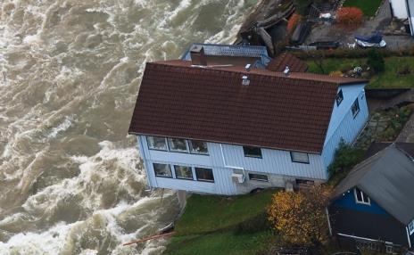
Severe Flooding Hits Western Norway. The flooding has been extensive, even historic in several areas, as Norway's The Local reports: "...Kronen said: “The
situation is far from being under control. The houses being taken by
the river will soon come to a closed off bridge south in Odda, and we
are paying close attention to the situation together with the army and
the fire department..."
Photo credit above: "A house on the River Opo, Odda, during the recent floods." Photo: Marit Hommedal/NTB scanpix.
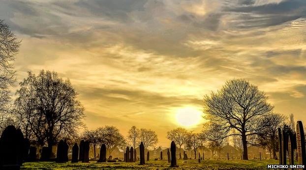
Photo credit above: "The sun rises above a graveyard in Normanton, West Yorkshire on the UK's warmest recorded Halloween." Credit": Michiko Smith.
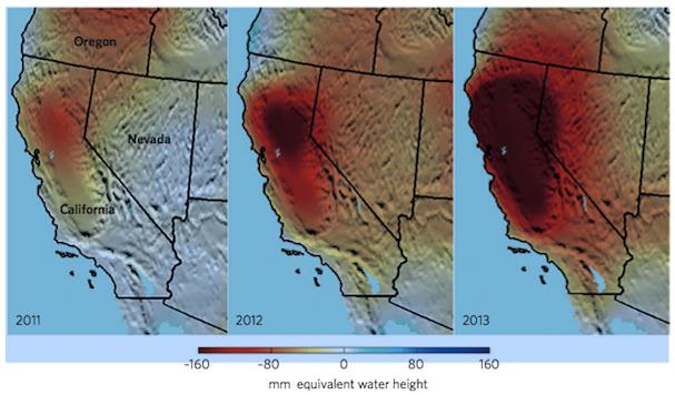
Image credit above: "Images by J.T. Reager, NASA Jet Propulsion Laboratory, California Institute of Technology, from "The Global Groundwater Crisis," Nature Climate Change, November 2014, by James S. Famiglietti."


Why The U.S. Has Fallen Behind In Internet Speed and Affordability. Where are the broadband disruptors? Because, according to this article at The New York Times, America's internet providers are providing substandard speeds at inflated prices; here's an excerpt: "...Downloading a high-definition movie takes about seven seconds in Seoul, Hong Kong, Tokyo, Zurich, Bucharest and Paris, and people pay as little as $30 a month for that connection. In Los Angeles, New York and Washington, downloading the same movie takes 1.4 minutes for people with the fastest Internet available, and they pay $300 a month for the privilege, according to The Cost of Connectivity, a report published Thursday by the New America Foundation’s Open Technology Institute..." (Graphic above: Mikey Burton).




TODAY: Cold start. Sunny & windy. Winds: SE 10-20+ High: 44
SATURDAY NIGHT: Clear and chilly. Low: 33
SUNDAY: Partly sunny, breezy and milder. High: 54
MONDAY: Clouds, period of PM rain. Wake-up: 40. High: 53
TUESDAY: Intervals of sun, fresh breeze. Wake-up: 38. High: 49
WEDNESDAY: Clipper arrives, few showers. Wake-up: 41. High: 53
THURSDAY: Sunny start, increase in PM clouds. Wake-up: 35. High: 50
FRIDAY: Breezy, stray shower late. Wake-up: 38. High: 52
Climate Stories...


* The Weather Channel's official Position Statement on climate change is here.



No comments:
Post a Comment