49 F. high in the Twin Cities Thursday.
51 F. average high on October 30.
50 F. high temperature on October 30, 2013.
Chilling
My
very own, personal Halloween Nightmare? Predicting 4 to 8 inches of
snow, only to wind up with closer to 30. That happened in 1991 - the
remarkable "Halloween Superstorm" - which broke multiple records.
My
personal paranoia peaks when weather stalls - that's when bad things
often unfold. Usually weather is progressive, systems move along at
10-30 mph, depending on the time of year. In late October, 1991 a storm
stalled off the coast of New England, the "Perfect Storm" popularized in
Sebastian Junger's book and subsequent movie. That stalled storm caused
a deepening storm over Minnesota to stall over Lake Superior,
prolonging our snow an extra 2 days, resulting in jaw-dropping snowfall
amounts.
According to the Minnesota DNR there have been only six
Halloweens with measurable snow since 1871. We won't add to that list
today. Expect clear skies with diminishing winds - temperatures falling
through the 30s by late afternoon. We've seen worse.
No big storms
(of any flavor) are brewing into the second week of November. A windy
weekend gives way to a few days in the 50s next week. Not exactly a warm
front, but considering we could be mired in hip-deep drifts I won't
complain.
* Thanks to Tom Oszman at TC Media Now for archiving
TV broadcast footage
from KARE-11, WCCO and KSTP, giving a glimpse of how all 3 stations
covered the 1991 Halloween Superstorm. Nice hat Paul. What were you
thinking?
A Storm For The Ages.
Check out the snowfall amounts from the 1991 Halloween storm; as much
as 3 feet along Lake Superior's North Shore, but 28" amounts into the
Twin Cities metro. Map courtesy of the DNR and Minnesota State Climate
Office.
Halloween Climatology In The Twin Cities. Here's an excerpt of a detailed look at Halloween weather over the years in the metro area, courtesy of the
Minnesota DNR: "...
Measurable
precipitation has occurred on Halloween only 26% of the time in the
Twin Cities, or 37 times out of 141 years. The most rain recorded was in
1979 with .78 inches. In 1991 .85 inches of precipitation fell, which
was snow. In spite of the 1991 Halloween Blizzard, measurable snow on
Halloween is about as rare as getting a full sized candy bar in your
trick or treat bag. Since 1872 there's been enough snow to measure only
six times: .6" in 1884, .2" in 1885, 1.4" in 1932, .4" in 1954, .5" in
1995 and of course 8.2 inches with the Halloween Blizzard of 1991..."
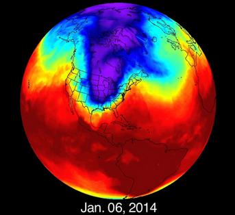
Not So Fast Polar Vortex! Why This Winter Might Not Be So Brutal After All. Note to self: don't bet the farm based on a 5 month forecast. Here's an excerpt from a story at
Salon that does a good job summing up what we know, and what we are pretending to know about the winter to come: "...
Sobel
says that despite the headlines, it’s doubtful we will be seeing a
winter as cold as last winter was in the eastern U.S. “Last winter was
very extreme by historical standards, so it is improbable in any year,”
says Sobel. “No information currently available (including the state of
El Niño), or that will be available ahead of time, is strong enough to
change that. It’s not impossible that this winter will be as cold or
colder than last, it’s just very unlikely.”
The U.S. Is Losing The Battle To Predict The Next Hurricane Sandy. Have we closed the gap with ECMWF? Not yet, explains meteorologist Andrew Freedman at
Mashable; here's an excerpt: "...
The
storm shined a spotlight on the superiority of a computer model run by a
European weather center, known as the European Centre for Medium-Range
Weather Forecasting (ECMWF), which, more than a week in advance,
pinpointed Sandy's infamous left hook track directly into New Jersey.
Now, two years after that monstrous storm, the same computing gap
remains — in some cases growing even wider. In addition, the Weather
Service is trying to shore up even more basic elements of its
infrastructure, like satellites and computer networks. These issues
raise the question of whether the agency is ready to face another Sandy..."
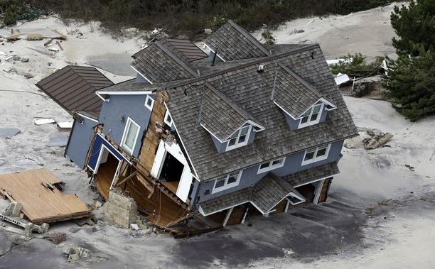
2 Years After Sandy U.S. Disaster Policy Is Still A Disaster. What have we learned from Sandy - are we better prepared for the next, inevitable superstorm? Here's the intro to a story at
Huffington Post: "
Two
years ago, Superstorm Sandy devastated the northeastern United States,
killing more than 70 people, causing $60 billion in damage and exposing
major gaps in federal disaster preparedness and response. But there has
been little movement in Congress to change policies to prepare the
country for future disasters. One thing Congress did was approve
billions in aid for storm-struck areas -- but not until nearly three
months after Sandy, on Jan. 28, 2013. And that package has been criticized in some corners for being both too slow and for including too few directives on rebuilding to make communities more resilient in future storms..."
Hurricane Sandy's Lesson: Resilience Isn't Enough. Here's a clip from a post at the
Harvard Business Review that caught my eye: "...
Building
resilience and adaptability are necessary actions and great to see. But
there is more than a hint of a defensive posture here – we’re being
reactive. Adaptation is critical, but as a sole strategy, it’s kind of
silly and potentially devastating. We can build some walls around lower
Manhattan but where will the water go? I don’t think New Jersey will
appreciate the extra dose of storm surge. And how high a wall can we
even build? If we continue with business as usual and think we’ll just
adapt, we will be sorely disappointed..." (File photo: AP).
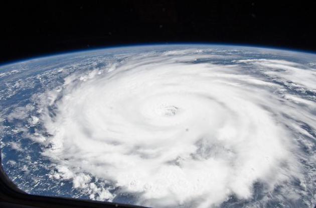
Hoboken Oceanographer Dreams of Slowing Hurricanes Before Landfall.
There are some practical considerations here, including what 30-50 foot
seas might do the pumps required, but under the headline of vetting all
ideas, here's an interesting one - an excerpt courtesy of
NBC New York: "...
His
plan is to slow down a hurricane by deploying hundreds of thousands of
floating tubular pumps -- directly in the path of an approaching storm.
Each pump would be upwards of a thousand feet long, using the kinetic
energy of undulating waves to draw cold water from the depths of the
ocean all the way to the surface. By cooling the surface water just two
degrees, Blumberg estimates a storm could be reduced from a category-3
to a category-1 designation. From a category-5 to a category-3
designation..." (Hurricane Igor file: NASA).
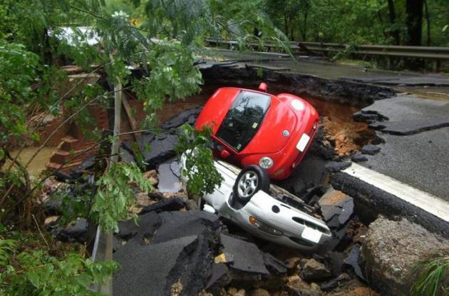
Study Says Upgrading Infrastructure Could Reduce Flood Damage.
Phys.org has the article which includes this interesting nugget: "...
From
1980 to 2007, about 90 percent of all global disasters were caused by
flooding either by rain, tsunami, hurricane or some other natural event.
At the same time, the American Society of Civil Engineer's 2013 Report
Card for America's Infrastructure gave the country a dismal D+. The
group said $3.6 trillion was needed by 2020 to address the most serious
problems..."
File photo credit: Virginia Department of Transportation.
Version 3.0 of Aeromobile Flying Car Unveiled. Where's my flying car?!! Another step closer to reality? Here's a clip from
Gizmag: "
It
may still sound like the stuff of science fiction, but the AeroMobil
flying car is close to a final design. The AeroMobil 3.0 prototype was
premiered today at the Pioneers Festival in Vienna. The
roadster-cum-light-aircraft is being tested to refine final performance
and features..."
TODAY: Chilliest Halloween since 2006. Sunny and colder than average. Winds: N 5-10. High: near 40
TONIGHT: Clear, light winds. Low: 25
SATURDAY: Hard freeze early. Partly sunny, windy. High: 44
SUNDAY: Plenty of sun, stiff breeze. Wake-up: 35. High: 51
MONDAY: More clouds, stray shower possible. Wake-up: 40. High: 55
TUESDAY: Partly sunny and cooler. Wake-up: 38. High: 48
WEDNESDAY: Clouds increase, showers north. Wake-up: 41. High: 57
THURSDAY: Sunny and brisk. Less wind. Wake-up: 37. High: 46
Overall, the researchers revealed a much wider problem.
From
1980 to 2007, about 90 percent of all global disasters were caused by
flooding either by rain, tsunami, hurricane or some other natural event.
At
the same time, the American Society of Civil Engineer's 2013 Report
Card for America's Infrastructure gave the country a dismal D+. The
group said $3.6 trillion was needed by 2020 to address the most serious
problems.
Read more at:
http://phys.org/news/2014-10-infrastructure.html#jCp.
Bloomberg has an interesting article about sea level rise and denial; here's an excerpt: "...
Yet adapt they must. An overheating planet is melting glaciers, raising sea levels and threatening cities from Mumbai to Guangzhou. Half the world already lives within 60 kilometers (37 miles) of the sea, according to the United Nations.
Waters creeped up an average 3.2 millimeters a year between 1993 and
2009; sea levels may rise by between 26 centimeters (10 inches) and 82
centimeters this century, the UN estimates..."
Fox News' Parent Company Is Really Worried About Global Warming.
Mother Jones has the curious details; here's a clip: "...
But Fox's parent company, 21st Century Fox, sees things differently. Earlier this month, a London-based organization called CDP
released hundreds of questionnaires it collected from
corporations—including 21st Century Fox—that had agreed to disclose
their greenhouse gas emissions and outline the risks global warming
could pose to their business. In its submission to CDP, 21st Century Fox
noted
that climate change "may increase the frequency and power of tropical
cyclones" and that the resulting storms could hurt its bottom line. And
the company cited Sandy as a prime example..."
Bangladesh Leads 32 Nations Hit By Extreme Climate Risk. Bloomberg has the story; here's the introduction: "
Bangladesh, Sierra Leone
and South Sudan led a ranking of countries facing extreme risks as a
result of climate change, exacerbating the chances of civil conflict,
according to a study by U.K. researcher Maplecroft. A total of 32
countries out of 196 surveyed face that level of threat, the Bath,
England-based analyst said today in an e-mailed statement. Nigeria, Chad, Haiti, Ethiopia, the Philippines, the Central African Republic and Eritrea rounded out 10 most at risk..."
* The report referenced in the Bloomberg article above is available at
maplecroft.com.
An Ill Wind Blows in Antarctica, Threatens Global Flooding.
What's happening in Antarctica, and why should people living within a
few feet of sea level be paying attention? Here's an excerpt from
Climate Central: "...
The
Southern Ocean’s legendary winds have been blowing more fiercely and in
a more poleward direction since the 1950s. Temperature observations are
sparse around the hostile continent, but scientists recently modeled
the ocean current knock-on effects of these wind changes, which have
been caused by ozone thinning and by the buildup of greenhouse gases. The scientists were blown away by the vicious climate change feedback that they unearthed..."
Photo credit:
"Antarctic tempest." Credit: Eli Duke/flickr.
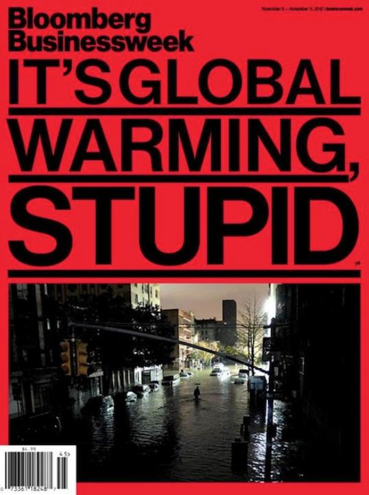
Superstorm Sandy Anniversary: "It's (Still) Global Warming, Stupid" A
higher sea level, more water vapor, warmer sea surface temperatures and
a highly unusual tropical track for late October - a warming climate
made Sandy worse. Here's an excerpt from
Think Progress: "...
So
we have nearly doubled the chances for a Sandy-type storm surge with
just the modest several-inch sea level rise we have caused to date with
carbon pollution. This study points out future Sandy-level storm surges
will result from weaker storms than Sandy as sea levels rise. The NOAA
study has an “intermediate high scenario” of 2 to 4 feet of sea level
rise by 2100 and a “High scenario,” where sea level rises 4 to 7 feet by
2100..."
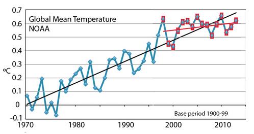
What Caused The "Pause" in Global Warming? Air
temperatures have leveled off; additional heat being pumped into the
oceans, according to climate scientist Kevin Trenberth. Here's an
excerpt of his explanation at
The Conversation: "...
These changes in the atmosphere cause changes in the ocean and have led to heat being stored deeper than 700m in the ocean.
while heat has also been carried down deeper in the subtropical
Pacific, away from the surface. The largest region of the planet that
has not warmed in the 2000s is the eastern half of the Pacific Ocean. The planet is warming, but heat is effectively being dumped deeper in the ocean..."
Graphic credit above: "
Global
mean surface temperatures as anomalies relative to 1900-99, plotted
with linear trends for 1970-2013 (blue) and 1998-2013 (red), (from
Trenberth et al. 2014)."
Trenberth et al (2014) Nature Climate Change .






No comments:
Post a Comment