52 F. high temperature in the Twin Cities Saturday.
52 F. average high on April 4.
40 F. high on April 4, 2014.
32.1" snow so far this winter season at KMSP.
69.5" snow fell last winter as of April 4.
April 4, 1928: Severe thunderstorms rumble through east central Minnesota. 100,000 dollars damage done at Anoka.
Water Wars
Minnesota
has been blessed with abundance: fertile fields, towering North Woods
and a constellation of sparkling lakes. By all measures we are
water-rich.
Climate disruption may turn out to be a good thing for
Minnesota, at least in the short term. Trends point to mellowing
winters, fewer subzero nights and ample moisture - most climate models
show Minnesota and the Great Lakes getting wetter as weather patterns
push north with a warming atmosphere.
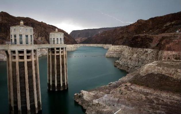
Meanwhile California, in the
midst of what some are calling the worst drought in 1200 years, is
facing water restrictions pitting city folk against farmers, the Bay
Area against Los Angeles. What happens when a major U.S. city runs out
of water? Call me paranoid but at some point there may be a push to tap
our water supplies. Wait for it.
A little slush is possible up
north Monday night, but a multimillion dollar rain is shaping up later
in the week. A slow-moving storm may drop half an inch to an inch of
rain; the best chance of puddles Monday, Friday and Saturday. Not
exactly drought-busting rains but a healthy dent in our dry rut seems
imminent, as southern storms finally draw near. Bring on the April
showers.
Happy Easter!
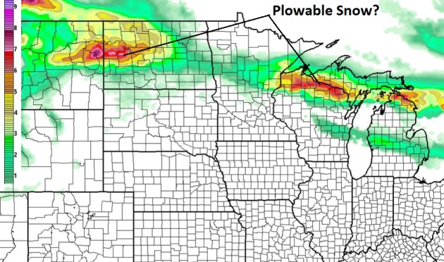
Slush Potential Up North.
Although the atmosphere should be just mild enough aloft for rain in
the Twin Cities, a coating of slush is possible near Little Falls and
Brainerd, maybe a couple inches of slushy snow in Duluth, even more over
far northern Wisconsin. 12 KM NAM accumulated snow forecast: NOAA and
HAMweather.
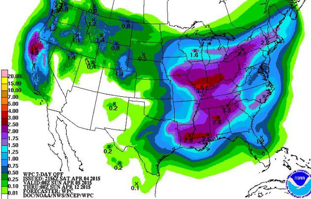
Limping Into A Wetter Pattern?
With 92% of Minnesota in moderate drought none of us will be
complaining about rain anytime soon. The core of the storm track shows
signs of lifting north next week, a more significant low pressure system
pushing a shield of heavier/steadier rain into Minnesota late in the
week. I wouldn't be surprised to see some .5 to 1" amounts over the next
week. QPF product: NOAA.
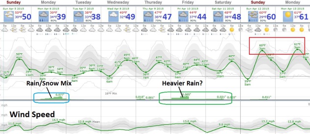
A Chilly, Damp Week.
The next few days may feel more like November than April as an
atmospheric tug-of-war plays out directly overhead. The first surge of
rain comes late tonight into Monday, mixed with wet snow up north.
Heavier rain pushes in Thursday night and Friday with showers lingering
into Saturday. It's early, but European and GFS guidance suggests Sunday
will be the sunnier, drier, milder day.
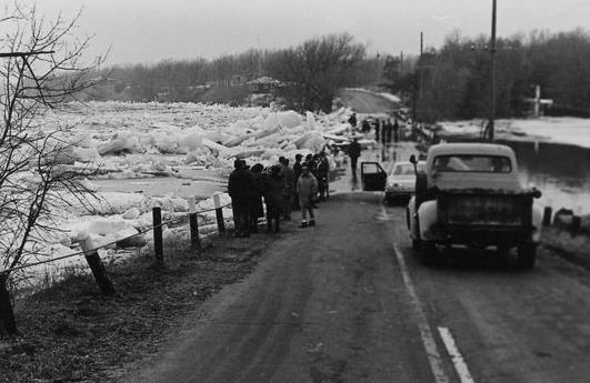
Ice Jam, Flood Wreaked Havoc in Sartell in '65. 1965 was the same year that EF-4 tornadoes steamrolled from Lake Minnetonka to Fridley, an amazing year, meteorologically.
The SC Times has a very good recap and compelling photos that capture historic flooding in central Minnesota; here's the intro: "
It's
been 50 years now. But Jan Bettenberg can still recall the sound. The
then-20-year-old Sartell resident had spent the night in his car
alongside the swollen Mississippi River, keeping watch on a massive ice
jam that had developed upstream north of the city. Then that April
morning in 1965, the jam broke, unleashing the wall of water behind it..."
Photo credit above: "
Massive chunks of ice overtake Gordon’s Bridge north of Sartell during April, 1965." (Photo: Courtesy of Stearns History Museum).
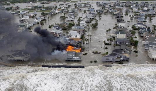
National Hurricane Center Will Test Storm Surge Watches, Warnings This Year. Because the surge, pushed ashore by low pressure and high winds, is also the biggest killer. Here's an excerpt from
The Capital Weather Gang: "
Beginning
this hurricane season, the National Hurricane Center will begin issuing
separate watches and warnings for storm surge and winds. The separate
watches and warnings will mean, “we can issue the warning more precisely
where hazard will be,” says Jamie Rhome, the National Hurricane
Center’s storm surge lead. “Another big advantage is it’s clear the
understanding and awareness of storm surge is not very high. Storm surge
is the big killer. We need to raise the awareness of storm surge...”
Photo credit above: "
Surge from Hurricane Ike inundates Galveston Island, Texas, and a fire destroys homes along the beach on Sept. 12, 2008." (AP Photo/David J. Phillip).
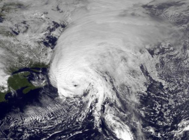
Hurricane Rain Slows Storms Up To 30%
Friction from falling raindrops may weaken, not intensify tropical
systems. Here's some breaking news and new research courtesy of
Science/AAAS News: "...
A
hurricane can dump nearly 2 trillion liters of water a day. But this
massive rainfall has an upside, according to a new study. Researchers
have discovered that the deluge can weaken the tempest by up to 30%—a
finding that may improve future storm predictions..." (Image: NOAA).
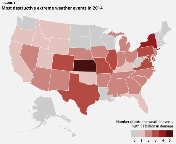
Extreme Weather On The Rise. In spite of major swarms of tornadoes or landfalling hurricanes, 2014 was still a very expensive year. Here's an excerpt from
The Center for American Progress: "
The
United States experienced eight severe weather, flood, and drought
events in 2014, each causing at least $1 billion in damage across 35
states. Overall, these disasters caused more than $19 billion in damage
and took 65 human lives. Building off of previous analysis, the Center for American Progress looked at disaster data from the National Oceanic and Atmospheric Administration, the Federal Emergency Management Agency, and Aon Benfield over the past four years and found that:
- There were 42 extreme weather events that each caused at least $1 billion in damage.
- These extreme weather events caused 1,286 fatalities and $227 billion in economic losses across 44 states..."
Map credit above: NOAA NCDC.
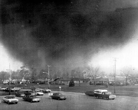
Xenia Tornado A Vivid Memory 41 Years later. WDTN in Dayton, Ohio has the story - here's the introduction: "
It
only took five minutes. The damage was widespread and deadly. Friday,
April 3, 2015 marks the 41st anniversary of the Xenia tornado. The F-5
tornado swept 300 mile per hour winds through the Greene County city,
killing 32 people and injuring more than 1,100 more. It caused
$100-million in damage. Images of homes flattened, trees stripped down
to nothing and stunned victims are as fresh today as they were in 1974.
Signs of hope promising to rebuild were erected by citizens, scrawled
out in spray paint..." (Photo credit: National Weather Service).
The Thirsty West: 10 Percent of California's Water Goes To Almond Farming. Meteorologist Eric Holthaus has the story at
Slate; here's an eye-opening excerpt: "...
California
almonds use a stunning 1.1 trillion gallons of water each year, or
enough for you to take a 10-minute shower each day for 86 million years
(using a low-flow showerhead, of course). Here’s the calculation:
California as a whole diverts or pumps 43 million acre-feet of water
each year to supplement its meager rainfall. In total, agriculture consumes 34 million acre-feet of that..." (Photo: Eric Holthaus).
Californians Who Conserved Fear State Can't Overcome Those Who Did Not. Get ready for Water Wars. Here's a clip from a
New York Times article: "..
.In
a state accustomed to cycles of drought and perennial water fights, the
need for such drastic cuts has highlighted discord between cities and
agricultural water users (who use about 80 percent of the developed
water supply), between California’s wetter north that pumps water to its
drier south, and between water’s frugal and spendthrift users..."
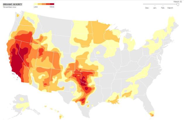
* At least 37% of the USA is in moderate drought or worse as of March 31.
Click here for an animated time line showing the intensification of drought since December.
The Real Cost of California's Drought. Not pricing water correctly - where have we heard that before (CO2). Here's an excerpt from
Bloomberg View: "...
I've seen a lot of apocalyptic writing about California only having a year of water left (not true), and
I've heard some idle talk about whether California can continue to
grow. But California's problem is not that it doesn't have enough water
to support its population. Rather, the problem is that its population
uses more water than it has to. And the reason people do this is that
water in California is seriously underpriced, as Marginal Revolution's Alex Tabarrok notes..."
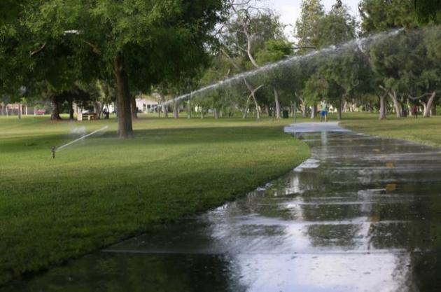
Photo credit above: "
Water
sprinklers are used at Heartwell Park in Long Beach, Calif., on
Thursday, April 2, 2015. California Gov. Jerry Brown on Wednesday,
ordered a 25 percent overall cutback in water use by cities and towns,
but not farms, in the most sweeping drought measures ever undertaken by
the nation's most populous state." (AP Photo/Nick Ut).
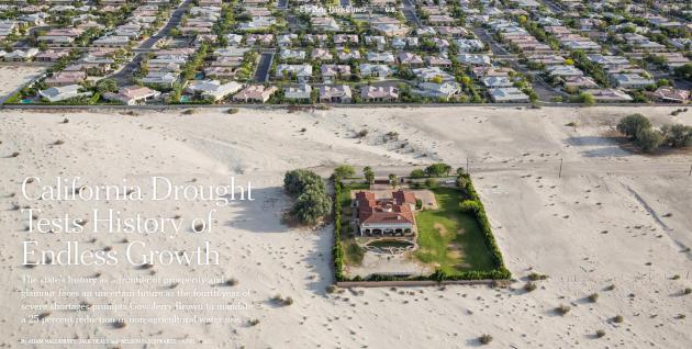
California Drought Tests History of Endless Growth. Here's an excerpt from a story at
The New York Times: "...
But even California’s biggest advocates are wondering if the severity of this drought,
now in its fourth year, is going to force a change in the way the state
does business. Can Los Angeles continue to dominate as the country’s
capital of entertainment and glamour, and Silicon Valley as the center
of high tech, if people are forbidden to take a shower for more than
five minutes and water bills become prohibitively expensive? Will
tourists worry about coming? Will businesses continue their expansion in
places like San Francisco and Venice?..."
Image credit above: "Homes
in Rancho Mirage, Calif., in the Coachella Valley. Gov. Jerry Brown has
ordered a 25 percent statewide reduction in non-agricultural water use." Credit Damon Winter/The New York Times
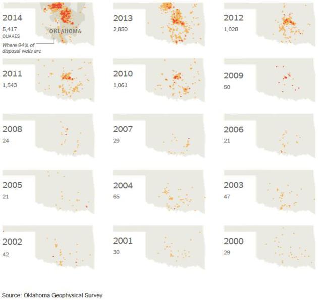
As Quakes Rattle Oklahoma, Fingers Point To Oil and Gas Industry.
Is high-speed injection of waste-water from fracking sparking a swarm
of tremors in Oklahoma? Scientists increasingly see a connection, as
reported at
The New York Times: "...
From
2010 to 2013, Oklahoma oil production jumped by two-thirds and gas
production rose by more than one-sixth, federal figures show. The amount
of wastewater buried annually rose one-fifth, to nearly 1.1 billion
barrels. And Oklahoma went from three earthquakes of magnitude 3.0 or
greater to 109 — and to 585 in 2014, and to 750-plus this year, should
the current pace continue. In the United States, only Alaska is shaken
more..."
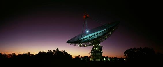
Are Aliens Behind Mysterious Radio Bursts? Scientists Weigh In.
To paraphrase George Carlin, don't sweat the slush or thundershowers!
We may have bigger issues. Cue the theme from X-Files. Here's an excerpt
of a head-scratcher of a story at
Huffington Post: "
What
are those things? For the past eight years, astronomers have been
scratching their heads over a series of strange radio signals emanating
from somewhere in the cosmos. And now, the mystery has deepened. A new
study shows that the so-called "fast radio bursts" follow a weirdly specific pattern -- a finding that the researchers behind the study say "is very hard to explain..."
The 7 Most Gloriously Disgusting Ballpark Snacks of 2015. After reading about these odd culinary diversions I'm feeling a little better about my diet. Here's an excerpt from
citylab.com: "...
A Royals' Class A club over in Delaware, the Wilmington Blue Rocks, has partnered with Krispy Kreme to offer its fans a hot dog wrapped in a Krispy Kreme donut and topped with a jelly and bacon crumble..."
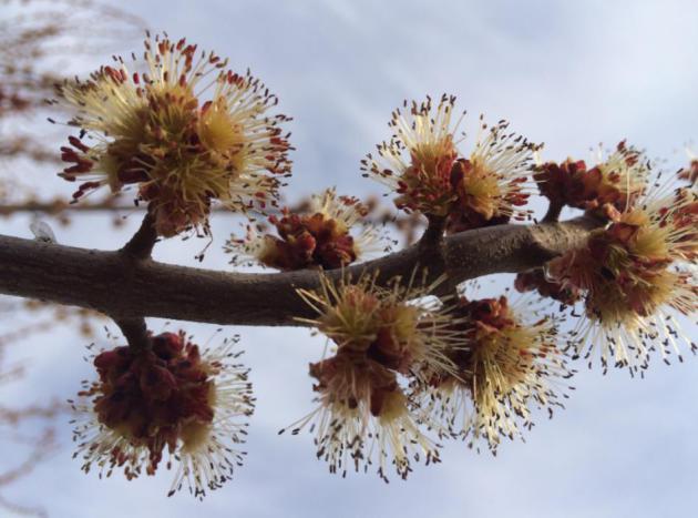
This Bud's For You!
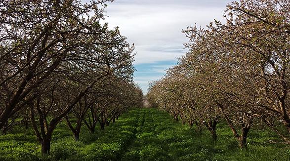
Media Logic meteorologist Todd Nelson sent me a photo of the massive
maple leaf buds sprouting in his yard. After the next dousing of rain I
expect rapid greening, statewide.
TODAY: More clouds than sun. Dry. Winds: E 10-15. High: 53
SUNDAY NIGHT: Cloudy, light rain - possible wet snow up north late. Low: 35
MONDAY: Cold rain, slushy mix up north? High: 41
TUESDAY: Drying out, clouds linger. Wake-up: 36. High: 43
WEDNESDAY: Clouds increase, rain at night. Wake-up: 38. High: near 50
THURSDAY: Lingering showers. Cool & damp. Wake-up: 39. High: 49
FRIDAY: Chance of a long, soaking rain. Wake-up: 41. High: 48
SATURDAY: Showers linger, still gray. Wake-up: 38. High: 49
Climate Stories....
Drought, Climate Change and California's Multibillion-Dollar Problem. Here's a clip from an Op-Ed at
Forbes: "...
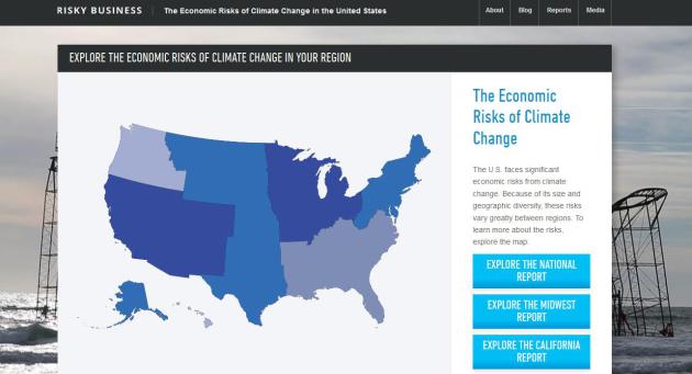
Short of such measures, the study — produced by the Risky Business Project,
which is co-chaired by former New York City mayor Michael Bloomberg,
former Treasury Secretary Henry Paulson and hedge-fund manager and
environmental advocate Tom Steyer — suggests that California will likely
face “multiple and significant economic risks from climate change,”
over the 21st century. This includes a likely doubling, and perhaps even
a tripling, of the average number of days above 95ºF and a 60 percent
to 90 percent decline in the average number of days below freezing
across the state..."
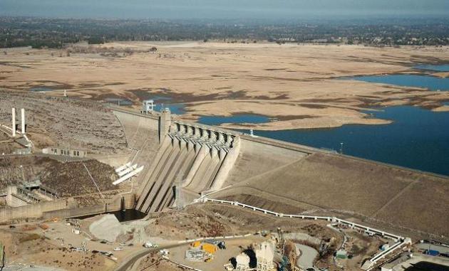
Photo credit above: "
As
California enters its fourth year of severe drought and the state’s
snowpack is at record lows, little water runoff is reaching reservoirs
and recharge ponds that capture water and that percolates through the
soil to replenish underground aquifers." (Photo: AP).
California Facing Extreme Heat Waves and Rising Seas. The
latest edition of "Risky Business", focused on the business risks of
climate change, focuses on California. Here's an excerpt of a story
summary at
Bloomberg Business: "...
The
average number of days with temperatures higher than 95 degrees
Fahrenheit (35 degrees Celsius) may double or even triple by the end of
the century, threatening one of the world’s richest agricultural
regions. At the same time, $19 billion in coastal property will likely
disappear as sea levels rise, the study found. The report is the third
from the Risky Business Project,
a nonprofit partnership of Bloomberg Philanthropies, the Paulson
Institute and TomKat Charitable Trust. It suggests California can reduce
these risks if policy makers and business leaders cooperate to reduce
emissions driving global warming and adapt to climate change..."
* The Risky Business Report focused on California is
here.
Epic California Drought is Preview of Future Global Warming Mega-Droughts. Alarmist hype? Stay tuned. Here's an excerpt from an Andrew Freedman story at
Mashable: "...
There
are two crucial differences between the droughts that occurred a
millennium ago and modern drought events, however. The first is obvious:
There are now about 38 million thirsty Californians living across the
state, watering their lawns and golf courses, and irrigating crops in
what is the most agriculturally productive state in the country. The
second has been clear to climate scientists for years, but is just now
gaining more public recognition. We are now seeing the rise of a new, supercharged type of drought,
in which global warming-related temperature extremes combine with dry
conditions to transform what would otherwise be an ordinary drought
event into a far more severe event..."
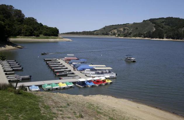
Photo credit above: "
Boats
are docked at San Pablo Reservoir Recreation Area in El Sobrante,
Calif., Thursday, April 2, 2015. A spokeswoman for the East Bay
Municipal Utility District said that the reservoir is about half full.
California Gov. Jerry Brown ordered officials Wednesday, April 1, 2015
to impose statewide mandatory water restrictions for the first time in
history as surveyors found the lowest snow level in the Sierra Nevada
snowpack in 65 years of record-keeping." (AP Photo/Eric Risberg).
Hot Hands: Fingerprints of Climate Change All Over California Drought. Meteorologist Jason Samenow has an explainer at
Capital Weather Gang; here's a snippet: "...
The added heat from climate warming acts to intensify the drought in important ways:
*
When it’s warmer, the evaporation of water speeds up, allowing the
ground to heat up faster, which then evaporates more water in a vicious
cycle which continues until meaningful rain stops it.
*
When it’s warmer, the snow season shortens. In other words, snow starts
falling later in the fall and stops falling earlier in the spring, and
snowpack declines..."
File photo above: NOAA.
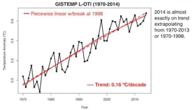
Long-Awaited "Jump" in Global Warming Now Appears "Imminent". The pause in (atmospheric) warming may be ending, according to a post at
ThinkProgress; here's the introduction: "
We
may be witnessing the start of the long-awaited jump in global
temperatures. There is “a vast and growing body of research,” as Climate
Central explained in February. “Humanity is about to experience a historically unprecedented spike in temperatures.” A March study,
“Near-term acceleration in the rate of temperature change,” makes clear
that an actual acceleration in the rate of global warming is imminent —
with Arctic warming rising a stunning 1°F per decade by the 2020s..."
Graphic credit above: "
NASA
temperature data dispel the myth of a recent slow-down in long-term
warming trend. But there was a big jump in temps during the mid-1990s.
Many scientists believe another jump is “imminent.’"


Thanks for sharing this useful information.
ReplyDeleteFire Damage Minneapolis