52 F. average high on April 5.
50 F. high on April 5, 2014.
April 5, 1999: Snow over the arrowhead. 11 inches falls at Two Harbors.
April 5, 1929: Tornado cuts a path from Lake Minnetonka through North Minneapolis and leaves six dead.

"There is no such thing as bad weather, only inappropriate clothing choices" goes the old Scandinavian proverb. I think we can all agree that a sun-soaked vacation or lukewarm, blue-sky Saturday qualifies as "good weather", but not always. Not when 92 percent of the state is in moderate drought. Not when we're tracking blowing dirt, low lake water levels and extreme fire danger.
"Paul, no editorials please. We don't want an opinion, just the facts please" critics charge. And everyone's a critic. But with concern growing about the impact of drought on Minnesota'a farming community the forecast models are overflowing with good news.
A mega-million dollar rain event is shaping up over the next week. ECMWF (European) model guidance prints out over 3 inches of rain by next Tuesday. Most farms, lawns & gardens should pick up at least 1-2 inches of rain over the next 7-8 days; the best chance of a soaking rain Friday, again Sunday. Waves of moisture ripple across Minnesota as a slow-moving storm tracks from Tulsa to Chicago. Finally.
An inch or two of slush may coat lawns from Nisswa to Sandstone tonight, but most of us enjoy a cold rain and 40s this week. Minnesota is about to turn neon-green.
Good weather indeed!
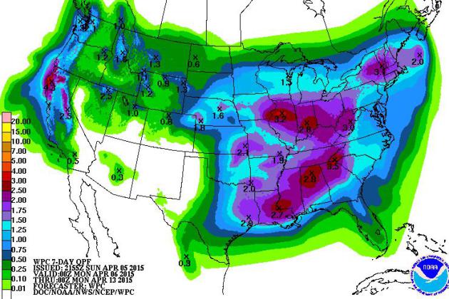
Trending Wetter. Much of Minnesota needs 2-5" of rain or more to pull out from moderate drought conditions. I can't promise that, but an inch of water over the next 7-8 days seems realistic for much of central and southern Minnesota. 7-Day rainfall guidance: NOAA.
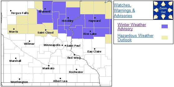
Winter Weather Advisory. Far northern suburbs of the Twin Cities may be waking up to a couple inches of slush on lawns, fields and slow-moving robins. A Winter Weather Advisory is posted from Brainerd and Little Falls to Princeton, Hinckley and Rice Lake. Details from the local NWS office in Chanhassen:
...WINTER WEATHER ADVISORY NOW IN EFFECT FROM 1 AM TO 10 AM CDT
MONDAY...

* TIMING...EXPECT A WINTRY MIX TO DEVELOP TONIGHT AND CONTINUE
  THROUGH EARLY MONDAY MORNING.

* SNOW ACCUMULATION...UP TO 3 INCHES.

* ICE ACCUMULATION...LITTLE TO NONE.

* MAIN IMPACT...ROADS COULD BECOME SLIPPERY DURING THE OVERNIGHT
  HOURS.
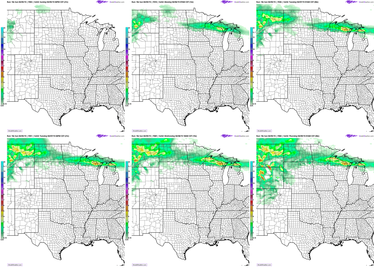
Slushy Lawns Up North. A few days ago we mentioned the possibility of snow (quite prematurely, I'm sorry to admit) and it still appears that some lawns and fields from Brainerd, Little Falls and Crosby eastward to Sandstone, Hinkley and Rhinelander may get slushed up with an inch or two. 12 KM NAM guidance courtesy of NOAA and HAMweather.
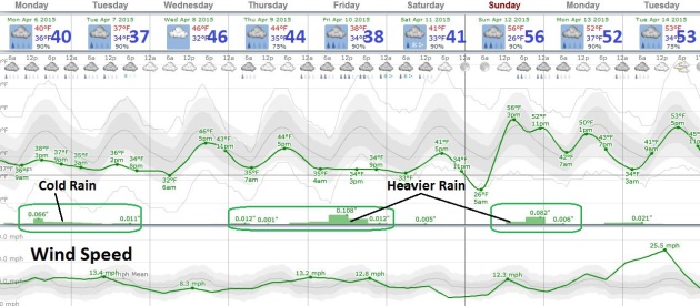
Memories of Early March. So much for 70s and 80s. Temperatures this week run a good 10F colder than average, but the chilly air sets the stage for an extended tug-of-warm overhead, with persistent overruning precipitation lingering into Saturday. Highs hold in the 40s (some 30s up north) with some slight recover by Sunday, when another round of heavier showers and T-storms may arrive later in the day. No complaints about the rain - we really need it. Graphic: Weatherspark.
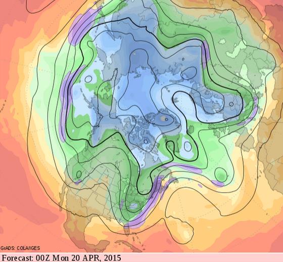
Warming Up Mid-April. This week looks chilly, no question about that, but looking out 2 weeks GFS forecasts for 500 mb winds show a long-wave ridge of high pressure treating much of the central USA to warmer than average temperatures - unusually chilly weather hanging on for the Great Lakes, New England and much of the eastern seaboard. Source: GrADS:COLA/IGES.
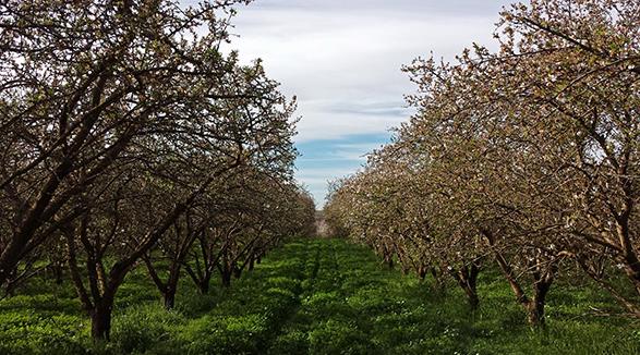
Beneath California Crops, Groundwater Crisis Grows.
At some point underground aquifers become depleted (or contaminated)
and you can't drill any deeper to find fresh water. Here's an excerpt
from The New York Times: "... Farmers
are drilling wells at a feverish pace and pumping billions of gallons
of water from the ground, depleting a resource that was critically
endangered even before the drought, now in its fourth year, began.
California has pushed harder than any other state to adapt to a changing
climate, but scientists warn that improving its management of precious
groundwater supplies will shape whether it can continue to supply more
than half the nation’s fruits and vegetables on a hotter planet..."
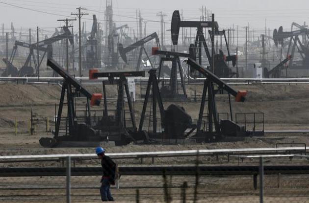
File photo credit above: "This
Jan. 16, 2015 file photo shows pumpjacks operating at the Kern River
Oil Field, in Bakersfield, Calif. California’s top regulators on
Tuesday, March 10, 2015 acknowledged lax oversight by the state had
allowed oil-and-gas industry contamination of protected water aquifers
and other threats to public safety, and pledged to intensify protection
of water sources and public health." (AP Photo/Jae C. Hong, File)
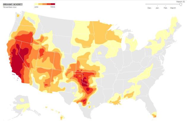
* At least 37% of the USA is in moderate drought or worse as of March 31. Click here for an animated time line showing the intensification of drought since December.
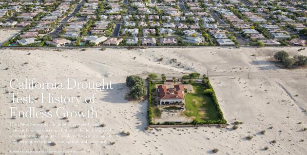
California Drought Tests History of Endless Growth. Here's an excerpt from a story at The New York Times: "...But even California’s biggest advocates are wondering if the severity of this drought,
now in its fourth year, is going to force a change in the way the state
does business. Can Los Angeles continue to dominate as the country’s
capital of entertainment and glamour, and Silicon Valley as the center
of high tech, if people are forbidden to take a shower for more than
five minutes and water bills become prohibitively expensive? Will
tourists worry about coming? Will businesses continue their expansion in
places like San Francisco and Venice?..."
Image credit above: "Homes
in Rancho Mirage, Calif., in the Coachella Valley. Gov. Jerry Brown has
ordered a 25 percent statewide reduction in non-agricultural water use." Credit Damon Winter/The New York Times
TODAY: Cold rain. Slushy mix up north. Winds: NE 10-20. High: 42
MONDAY NIGHT: Rain and drizzle. Wet snow possible north of MSP. Low: 36
TUESDAY: Good and soggy. More rain likely. High: 42
WEDNESDAY: Still gray, but a drier day. Wake-up: 35. High: 47
THURSDAY: More rain, best chance southern MN. Wake-up: 38. High: 46
FRIDAY: Heavier, steadier rain expected. Wake-up: 37. High: 49
SATURDAY: Showers taper, clouds linger. Wake-up: 36. High: near 50
SUNDAY: Peeks of sun, late-day T-storms. Wake-up: 40. High: 58
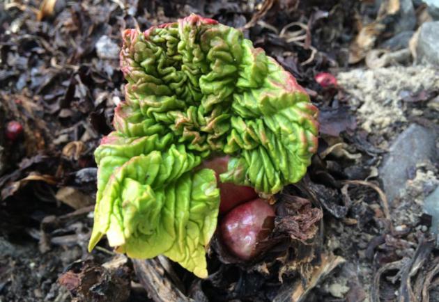
* Photo above courtesy of Media Logic meteorologist Todd Nelson, who assures me rhubarb are coming up in St. Michael.
Climate Stories....
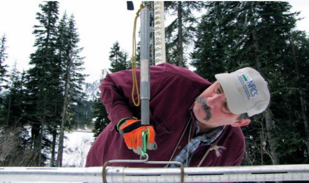
Record Low Snowpack in Pacific Northwest Could Be "Dress Rehearsal" for Climate Change. PRI, Public Radio International, has the story - here's the intro: "When
officials in drought-stricken California found last week that snowpack
levels in the Sierra Nevada mountains were at historic lows, they took
drastic action, implementing
unprecedented water-use restrictions. But record-low snowpacks aren’t
just a thing in California. They’re also happening further north. In
western Washington, snow levels are more than 90 percent below normal,
and statewide the snow level is at 71 percent below where it should be.
The situation is even more severe in Oregon, which has received less
than a quarter of its normal snowfall..."
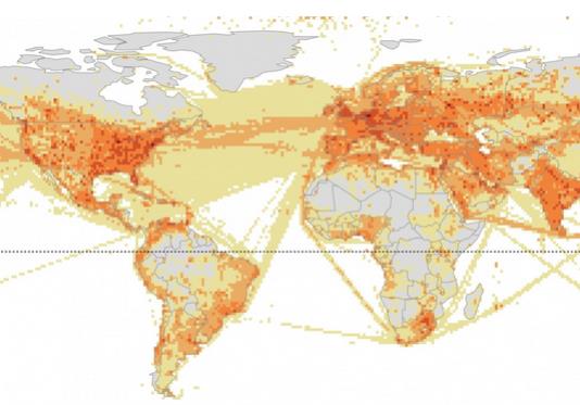
Infographic credit above: "Where carbon emissions are greatest". (Kennedy Elliott)
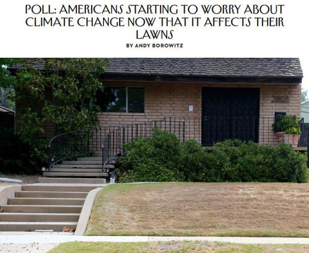
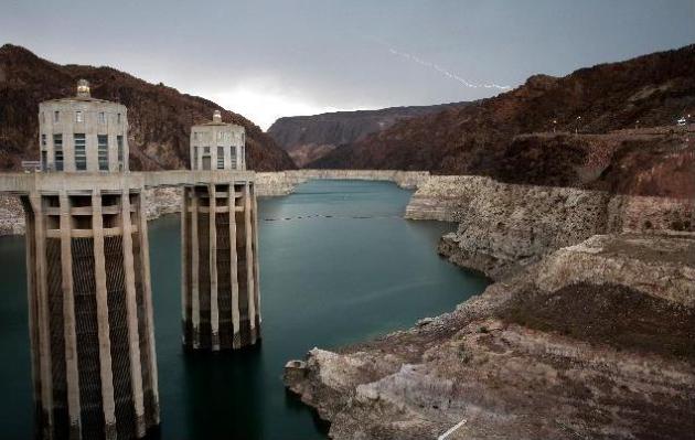
Photo credit above: "As California enters its fourth year of severe drought and the state’s snowpack is at record lows, little water runoff is reaching reservoirs and recharge ponds that capture water and that percolates through the soil to replenish underground aquifers." (Photo: AP).
If you are looking for home & office bottled water in San Antonio then Artesia springs is the end destination for you which provides purified bottled water. For more details please visit our website http://www.artesiasprings.com or call us at (210) 637-5554
ReplyDelete