76 F. high at MSP International Airport Monday.
57 F. average high on October 19.
69 F. high on October 19, 2014.
October 20, 2002:
Heavy snow across central Minnesota. It fell in a 10-20 mile wide band
from southeast North Dakota to around Grantsburg Wisconsin. Little Falls
picked up nine inches.
October 20, 1916:
Snow fell in south central Minnesota with 4.5 inches recorded in New
Ulm, 4 inches in Farmington and Hutchinson, 3.5 inches in Montevideo,
and 3 inches in Faribault.
October 20, 1835: 6 inches of snow fell at Ft. Snelling.
Super-Sized SeptemberWinter on Indefinite Hold
Every
day is a gift. Even the lousy ones. Every day I can torment my
neighbors wearing shorts and t-shirts is a good day, in my humble
estimation.
NOAA informs me that half a foot of snow fell on
Fort Snelling on this date in 1835. Yes, we could be ankle-deep in slush
on the 20th day of October. My father, who lives in Lancaster,
Pennsylvania, reported flurries
on Sunday. "No snow in the Twin Cities yet, Dad!" sounding a little like a hyperactive kid at Christmas. Yes, it's been an amazing autumn, coming after a memorable summer.
Early
cold fronts often set the tone for the winter to come. Not always, but
many winter. At the rate we're going this may be one of the milder,
drier autumns in Minnesota history.
To date the entire state is
experiencing the 4th driest October since 1895, according to
AerisWeather meteorologist D.J. Kayser. Symptoms of El Nino kicking in;
warm water in the Pacific penetrating unusually far inland? Probably.
For the record the average date of first flurries at MSP is
November 4. First inch?
November 18. Just trying to cheer you up.
Today's weather may put a spring in your step: another shot at 70F. Rain arrives
Friday but skies clear in time for another fine fall weekend.
Unusual warmth spills over into at least the first week of November. No complaints here.
*
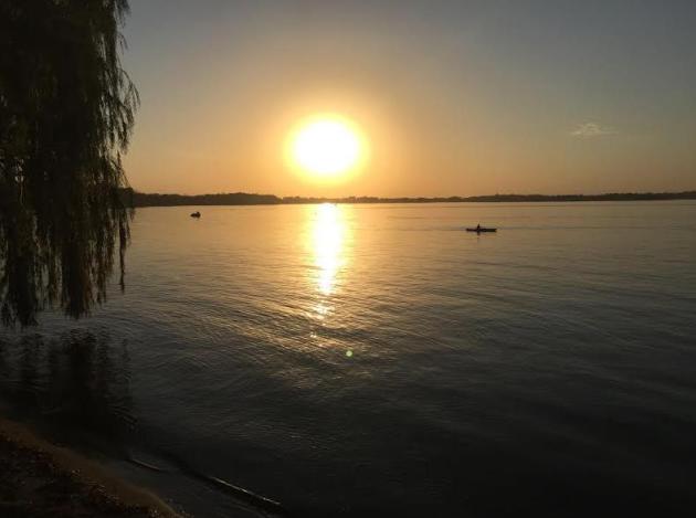
Kayaks and cruisers on the lake....on October 19? Nothing like a 5
month boating season. In Minnesota. The high at MSP yesterday was 75F, 1 degree warmer than LAX, Los Angeles International Airport. You don't see that very often in late October. Source:
NOAA.
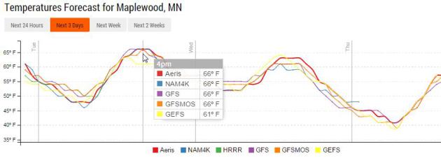
Rare Model Alignment.
Yes, the models are almost unanimous that (in theory) temperatures
should top off around 66F in Maplewood at 4 PM this afternoon. We'll
have to be content with afternoon temperatures only 10F warmer than
average. Source: Aeris Weather.
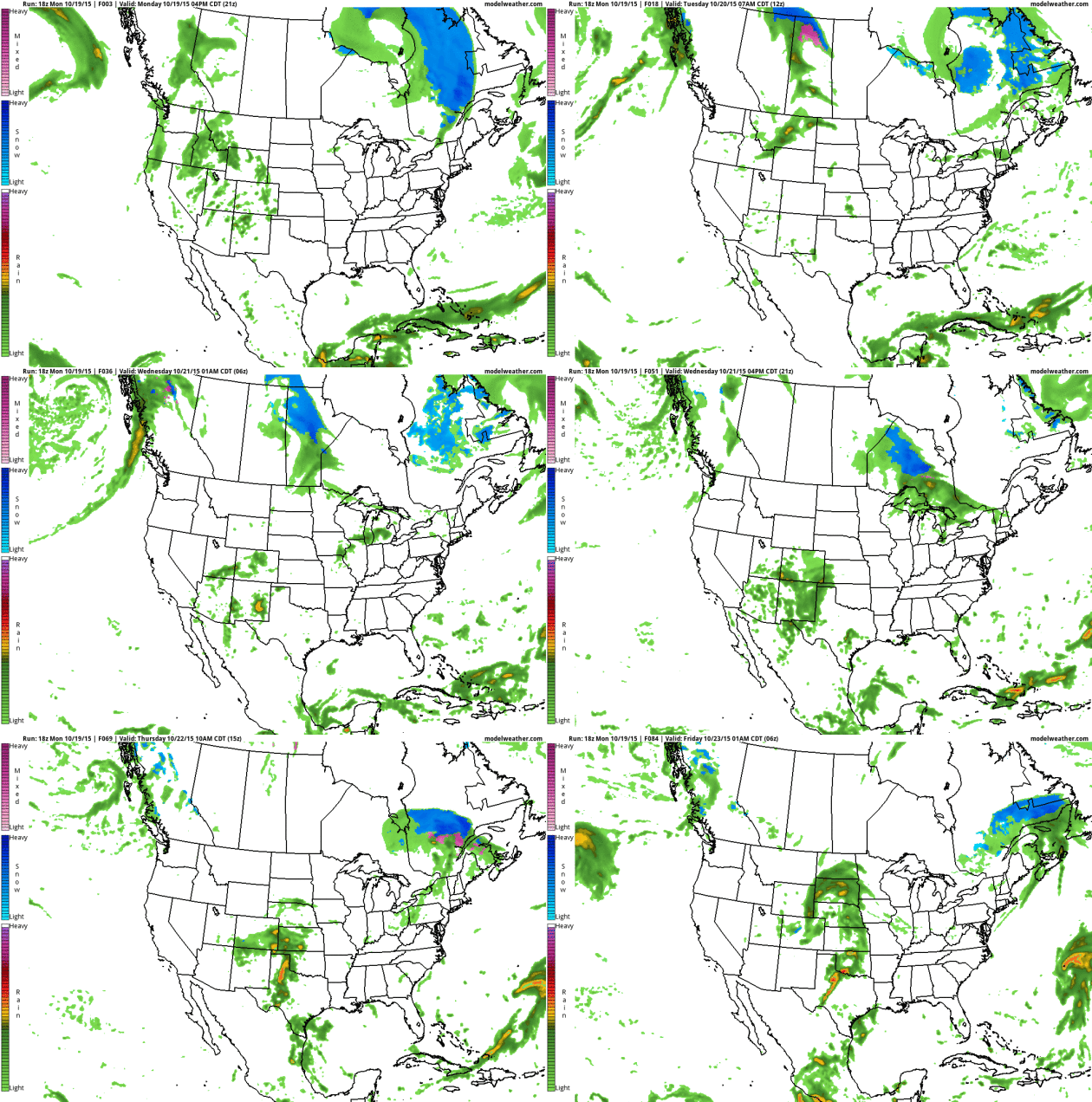
Wintry Weather Tracks North of USA.
NOAA NAM guidance shows accumulating snow (shaded in blue) tracking
well north of the U.S. border - treating our Canadian friends to a
winter wonderland. A strong zonal flow is keeping much of the USA milder
than average, but at some point the law of averages will catch up with
us. Source: AerisWeather.
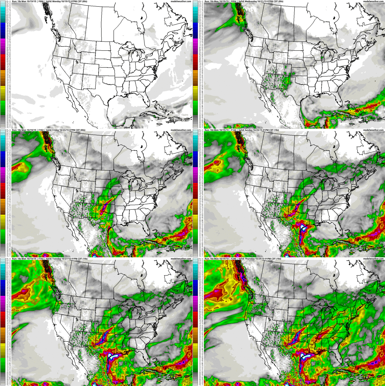
Texas Soaking?
10-Day GFS guidance prints out some excessive amounts of rain near
Corpus Christi and Houston, where the risk of flash flooding will be
significant by the end of the week. According to NHC there is still a 0%
risk of tropical storm formation over the next 48 hours. You can also
see the plume of tropical moisture surging north across the Great
Plains, treating us to a much-needed dousing on Friday.
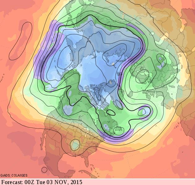
Mild Start to November - Thanks to Persistent Zonal Flow.
Whether it's the first symptoms of El Nino or just random atmospheric
variability, 500 mb winds aloft are forecast to blow from west to east, a
relatively mild, dry pattern for most of the USA as we sail into
November. Source: GrADS:COLA/IGES.
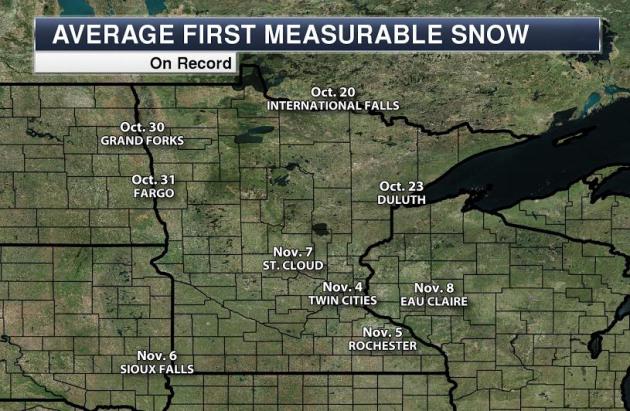
Average Date of First Trace of Snow.
Although flurries are common in mid and late October the average
(median) date of the first trace of snow, enough to ice up sidewalks and
side streets, is November 4 in the Twin Cities, according to NOAA
records. Source: meteorologist D.J. Kayser at AerisWeather, who adds: "
If
MN saw no more rain this month, and it did average out to be 0.40"
across the state, it would be the fourth driest October since 1895 on
record for the state."
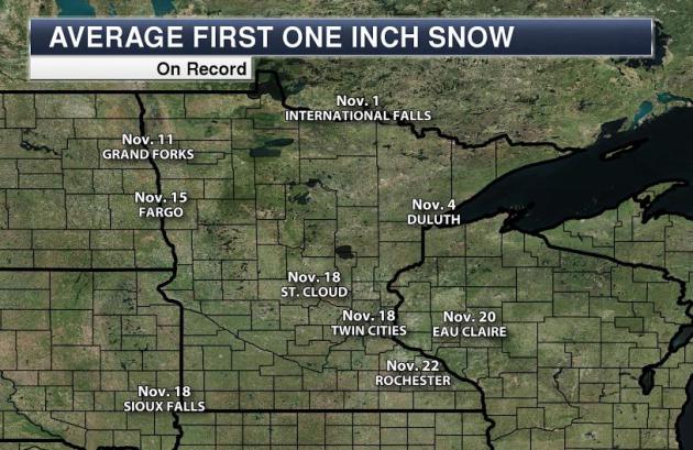
Average Date of First Inch of Snow.
Hey, I'm just trying to cheer you up. Imagine what a treat I-494 in
Maple Grove will be in a month or so? God help us. The average date of
the first inch of slush in the metro is November 18. Circle your
calendars. Does anyone use calendars anymore?
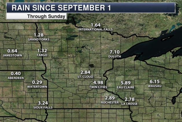
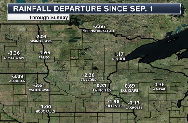
Rainfall Since September 1.
The Twin Cities, Duluth and Eau Claire have picked up ample moisture,
but note the sharp drop-off in precipitation north and west of the Twin
Cities. Source: AerisWeather.
Rainfall Deficit Since September 1.
It dries out the farther north and west you go across the state. St.
Cloud reports a 2.26" rainfall shortage since September 1; well over 3"
for much of South Dakota.
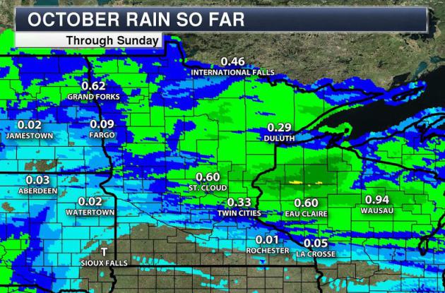
A Dry, Lukewarm October To Date.
Symptoms of El Nino kicking in? Perhaps. Warm phases in the Pacific
often result in drier, milder weather downwind across the Upper Midwest.
Source: AerisWeather.
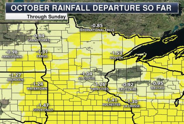
October Moisture Deficit.
Although a boon to farmers trying to get out into their fields with
harvest, the top layers of topsoil need to be recharged with moisture
before the ground freezes solid, or there may be issues for spring
planting in 2016.
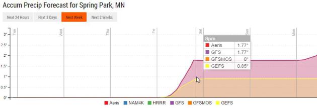
Friday Soaking?
All or nothing. A stray shower can't be ruled out today, but the best
chance of rain all week comes Friday; some models printing out over 1"
of rain during the PM hours on Friday. Skies still clear out on Saturday
behind a cool frontal passage. Please God. Graphic: Aeris Enterprise.
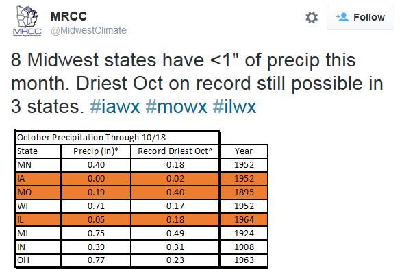
Driest October on Record for Iowa, Missouri and Illinois? As of October 19 that's the case, according to The Midwest Regional Climate Center.
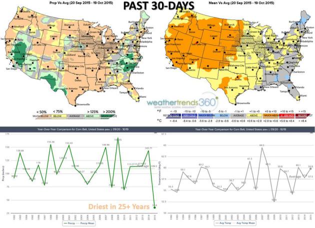
Driest Harvest in Decades - Are Flood Gates About To Open Up? Harvest weather has been near-perfect for farmers in the corn belt; here's an excerpt from
Agweb.com: "
We've
had the holy grail of exceptional harvesting weather with the Corn Belt
trending the driest in over 25 years with near record dry weather over
the past 30 days. Temperatures up until this most recent cold snap have
also been well above average for the Corn Belt, especially the Western
Corn Belt and Plains. The maps/charts (above) show the weather trends
over the past month with the major Corn Belt counties outlined..."
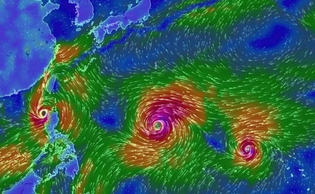
Worst Flooding Still To Come in Philippines from Koppu; Champi Now a Super Typhoon. Here's the intro to an update at
Weather Underground: "
Although it has weakened to Category 1 strength since making landfall, Typhoon Koppu
continues to hold high potential for catastrophic multi-day rainfall in
the large Philippines island of Luzon. Koppu edged into the east-coast
province of Aurora around 1:00 am Sunday local time
as a super typhoon, packing top winds estimated by the Joint Typhoon
Warning Center (JTWC) at 150 mph. Fortunately, this part of Luzon is
fairly sparsely populated, though two fatalities had been reported
by Sunday evening local time. Tree and structural damage and power
outages are widespread. At least 9 million residents of Luzon--close to
10 percent of the population of the Philippines--were without power as
of Sunday afternoon local time (midnight Saturday night EDT), according
to data from the Philippines National Disaster Risk and Reduction
Management Council..."
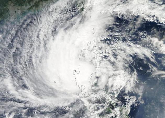
Image credit above: "
MODIS
image of Typhoon Koppu over Luzon Island in the Philippines as seen from
NASA's Terra satellite on Sunday, October 18, 2015. At the time, Koppu
was a Category 2 storm with 105 mph winds." Image credit:
NASA.
* Reports of 31"+ rains (and the rain continues to fall) from Typhoon Koppu, details via
Mashable.
Tropical Storm Koppu (Lando) Drenching the Philippines; Flooding, Mudslides Possible. More perspective from
The Weather Channel;
here's the intro: "Tropical Storm Koppu, known as Lando in the
Philippines, is drenching the country's main northern island of Luzon
and will continue to do so through early this week, bringing a risk of
life-threatening flash floods and mudslides. More than 2 feet of rain
has been reported so far in the northwestern part of the country, and
more rain is likely into Wednesday. Among the hardest-hit areas are the
eastern coastal towns of Baler and Casiguran,
where significant building damage has been reported.
Some of the most widespread flooding has been reported in the province
of Nueva Ecija, including the inland city of Cabanatuan, about 60 miles
north of Manila. The Associated Press reported that some villagers in
the province were trapped in their homes and on rooftops..."
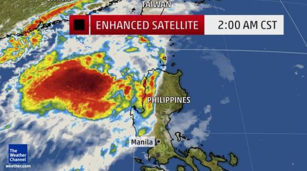
Image credit above: "
This
infrared satellite image is enhanced to show colder, and therefore
higher, cloud tops in various shades of red and violet. Such clouds are
associated with vigorous thunderstorms. Wind data may disappear if the
observing equipment is damaged."
Philippines' Typhoon Koppu Brings Severe Floods. Here's an excerpt from
The BBC: "...
Unlike
previous tropical cyclones, the threat from typhoon Koppu is not so
much from the wind but from the massive amount of rain. More than a
metre of rainfall is forecast in just a few days in Luzon province. That
is double what London gets in an entire year. In the south of Luzon, it
has brought severe flooding with whole villages under water. But
perhaps more dangerous are massive landslides. The fear is that with the
ground heavy and saturated with water, whole hillsides could collapse..."
Image credit above: "
With rains still falling, the risk of flooding is even greater than during typical storms and typhoons." Source: EPA.
While Atlantic Has Been Mild, Pacific Storm Season Has Been Wild.
A warmer Pacific is brewing up more severe hurricanes and typhoons. ACE
values are off the scale, as highlighted in a good summary at
USA TODAY; here's a clip: "...
The
best way of measuring a season's ferocity, Klotzbach said, is by
"Accumulated Cyclonic Energy" (ACE), a measurement that takes into
account the number, strength and duration of all the storms put
together. "ACE is not only a measure of tropical cyclone activity, but a
measure of the damage potential of an individual cyclone or a season,"
according to the Weather Underground. The ACE this year in the Pacific
is 615, which is the highest for this period since accurate records
began to be kept in 1971, Klotzbach said..."
El Nino Lifts Odds of Wetter South, Drier North This Winter. Which is the official NOAA forecast for the winter months; here's an excerpt from
Climate Central: "...
Overall, though, winters across the U.S. are trending warmer, as global temperatures rise
due to the buildup of heat trapped by increasing amounts of greenhouse
gases in the atmosphere. Last winter was the warmest on record globally,
in fact, and 2015 as a whole is very likely to be the hottest year in the books. While El Niño
is a cyclical climate phenomenon marked by unusually warm waters in the
eastern tropical Pacific, it can affect the weather around the globe
because it alters the transfer of heat from the ocean to the atmosphere.
This shifts around wind patterns
there and has a domino effect through the atmosphere; over the U.S., it
causes a shift in the position of the wintertime jet stream, which
controls how storms move across the country..."
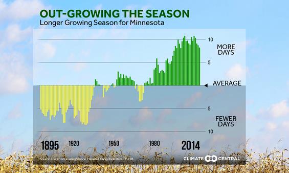
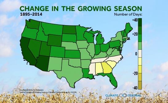
Change in the Growing Season.
It's not a climate model, it's reality - the growing season is already
longer in Minnesota, to the tune of at least 2 months. Here's an excerpt
from
Climate Central: "
As
the planet warms from the burning of fossil fuels and the buildup of
greenhouse gases in the atmosphere, the length of the growing season
will continue to be affected. Nationally, the growing season is already
about 15 days longer than at the beginning of the 20th century. Western
states have seen the greatest changes since that time. Arizona,
California, Nevada, and Oregon now have growing seasons that are more
than a month longer than they were a century ago. In turn, this will
influence when, where, and what types of food crops are planted and
harvested – meaning agricultural practices will have to adapt – and
impacting the types of produce available at your local supermarket..." (graphic above and below: Climate Central).
El Nino Impacts on Ocean Warming. El Nino warming is superimposed on a global warming trend of the world's oceans. Here's an excerpt from
Climate Central: "
This
year is on track to be the hottest on record globally. The strong El
Niño is likely playing a role as the average global temperature of an El
Niño year is 0.4°F higher than a La Niña year. However, the strong El
Niño is not solely responsible for the warming planet. Global
temperatures have been trending upward since 1950, regardless of whether
or not the Pacific Ocean was in an El Niño, La Niña, or neutral phase.
In fact, La Niña years in the 21st Century are now warmer than El Niño
years just 30 years ago. Similarly, the long term trend of global ocean
water temperatures is on the increase, emphasizing that El Niño is only
magnifying the ongoing warming trend..."
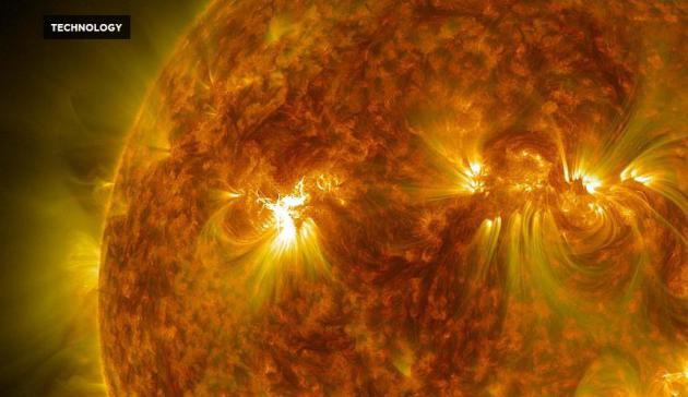
How Accurate Are Solar Flare Detection Technologies?
Short answer: not very, and the really big solar storms, the X-level
events, may not be detected in advance, according to a story at
RedOrbit; here's an excerpt: "
A
new study from the Tihany Magnetic Observatory in Hungary has explained
why solar weather indicators wouldn’t have been able to predict the
Carrington Event, a large solar storm that occurred in 1859, according
to a press release from the Spanish Foundation for Science and
Technology (FECYT). Predicting solar flares is important for keeping
power supplies and communication networks safe, as the flairs can
disrupt or even damage electronics. However, the methods currently used
to predict solar storms aren’t perfect..." (Image credit: NASA).
Cybersecurity Firm Says Chinese Hackers Keep Attacking U.S. Companies. Here's a clip from
The New York Times: "...
In a blog post
on Monday, the security services provider CrowdStrike, based in Irvine,
Calif., said that it had tracked a number of attacks on American tech
and pharmaceutical companies leading up to and after Mr. Xi’s visit to
the United States last month. (Mr. Xi has been logging airtime, making
his first state visit to Britain this week.) “We detected and stopped
the actors, so no exfiltration of customer data actually took place,”
according to the post, written by the CrowdStrike co-founder and chief
technology officer Dmitri Alperovitch..." (Image credit:
Georgetown Law).
Why You Didn't See It Coming.
Nautilus
has a long (but brilliant) article about scale, cognition and the
ability to sense big changes coming. Or not. Here's an excerpt: "...
We
do have a way to “see it coming,” whether it’s environmental tipping
points or financial ones. It’s science. The whole point of science is to
penetrate the fog of human senses, including common sense. Ingenious
experiments and elegant equations act as extensions of senses that allow
us to see farther and more precisely—beyond the horizons of what we
think we know. Calculations predict possible futures, find clear signals
in the almost constant noise. Science predicted that massive stars
would implode, nuclear bombs would explode, and humans could well
destroy their own habitat (if they didn’t begin to take seriously
problems like overpopulation and resource depletion). Sometimes science
requires us to accept the unacceptable, certainly the unpalatable: What?
Drive smaller cars? Give up my lawn? Be satisfied with a small house?.."
Wealth Therapy Tackles Woes of the Rich; "It's Really Isolating to Have Lot's of Money". Yes, we should all have such problems - maybe Oprah will highlight the travails of the 1% Here's an excerpt from
The Guardian: "...
And
as they stroll through Manhattan, what issues are America’s 1%
struggling with? There is guilt over being rich in the first place, he
said. There is the feeling that they have to hide the fact that they are
rich. And then there is the isolation – being in the 1%, it turns out,
can be lonely. It seems F Scott Fitzgerald was right, the very rich “are
different from you and me”. Especially in 2015..."
An Amphibious...Motorcycle? It's official; now I really have seen everything. Details at
Gizmag: "
Serial
amphibian creator Alan Gibbs has used the American International
Motorcycle expo in Florida to launch three new outrageous recreational
vehicles. Not satisfied making ridiculously fun-looking amphibious
quadbikes, cars and trucks, Gibbs has now built two-and three-wheeled
motorcycles that you can ride straight down a boat ramp into the water.
At the touch of a button they convert to jet skis, retracting wheels out
of the way and switching to jet propulsion..."
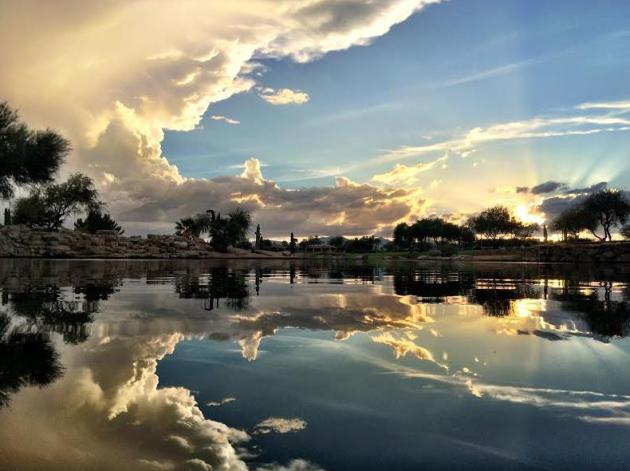
* Photo above courtesy of AerisWeather meteorologist Todd Nelson, who snapped this in Surprise, AZ.
TODAY: Intervals of mild sun, isolated shower possible. Winds: E 8-13. High: 69 (70s southern MN)
TUESDAY NIGHT: Patchy clouds, few showers. Low: 53
WEDNESDAY: Early shower, PM clearing. Winds: NW 10-15. High: 63
THURSDAY: Sunny, light winds. Wake-up: 43. High: 62
FRIDAY: Dry start to the day. PM showers likely. Winds: SE 10-20. Wake-up: 49. High: 59
SATURDAY: Partly sunny, breezy and cooler. Winds: NW 8-13. Wake-up: 48. High: 57
SUNDAY: Plenty of cool sunshine. Winds: E 7-12. Wake-up: 41. High: 54
MONDAY: More clouds, few showers likely. Wake-up: 43. High: 52
Climate Stories...
Congressmen Want Probe of Exxon Mobile "Failing to Disclose" Climate Change Data. Here's an excerpt from
The Los Angeles Times: "
Members
of Congress are asking for a federal investigation into Exxon Mobil.
Rep. Ted Lieu (D-Los Angeles) and Rep. Mark DeSaulnier (D-Walnut Creek)
wrote a letter Wednesday to Atty. Gen. Loretta Lynch asking the
Department of Justice whether the company violated the law by “failing
to disclose truthful information” regarding climate change. The letter
cites recent investigations by the Los Angeles Times,
Columbia University’s Energy and Environmental Reporting Project, and
Inside Climate News, which showed the company incorporated climate
change research into its operations while publicly casting doubt on that
very same science..."
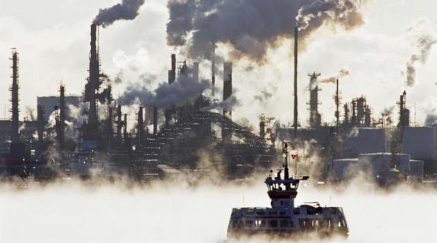
Photo credit above: "
Imperial Oil’s Dartmouth refinery in Halifax, Canada. Exxon Mobil owns about 70% of the company." ((Andrew Vaughan / The Canadian Press, Associated Press)).
Can Oil, Gas Companies Really Be Climate Leaders? Here's a clip from an Op-Ed at
USA TODAY: "...
Some
skepticism is understandable. Of the three pillars of a successful
energy system — security, affordability and sustainability — the
industry has been more adept at responding to consumer demands for
security and affordability than addressing concerns over sustainability.
Some may wonder if big oil is trying to secure a seat merely to slow
the process down. I believe we should listen and examine how these CEOs
plan to address the issue. As a former employee, I know that oil
companies are used to thinking big and acting big — bigger than most
companies in most sectors, and often bigger than many states..."
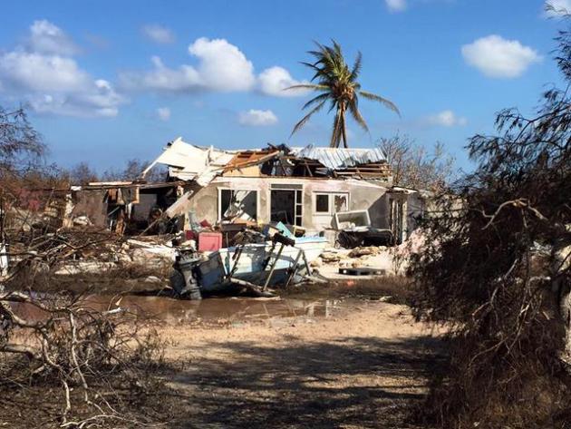
The Bahamas: There's No Forgetting the Role Climate Change Played in our Destruction. Hurricane Joaquin was the first Category 4 hurricane to hit the Bahamas since 1866.
350.org has the story - here's an excerpt: "...
For
The Bahamas, climate change is an issue of access. More than access to
adaptation funding, but access to food security, access to adequate
public health, access to the fisheries and access to a Bahamian way of
life that has existed for generations. Our country is fighting what appears to be a losing battle with the elements that have supported our existence for centuries.
The sea is reclaiming the land; the ocean is killing off its contents
through ocean acidification, the temperature is leading to disease
(vector borne and heat related). We are finding it difficult to keep up..."
Photo credit above: "
The remains of a house in Long Island, The Bahamas." Source: Long Island Hurricane Relief Facebook Page.
Is Climate Change The New Big Election Issue for Latino Voters? Here's a snippet from a story at PRI,
Public Radio International: "...
Latinos
live in areas that are vulnerable to climate change. In fact, if you
look at the Latino population, 49 percent of us live in coastal
shoreline counties, compared to 39 percent of the general population. So
we are starting to see the impacts, and we are starting to see them in
our communities,” says Nicole Hernandez Hammer, a southeast climate
advocate with the Union of Concerned Scientists. Another poll
from The New York Times and Stanford University, conducted at the
beginning of 2015, found that 54 percent of Latinos rated global warming
as being extremely or very important to them personally, compared with
37 percent of white respondents..."
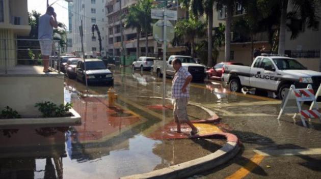
Photo credit above: "
Following
what the National Weather Service described as "high astronomical tides
due to the lunar cycle," a coastal flood advisory was put in place for
South Florida early this week. Pictured above is flooding that occurred
in Miami Beach at Indian Creek Drive and 30th Street on September 28,
2015." Credit: Photo by Emily Michot/
Miami Herald Staff.
Climate Realities Sink In. Here's an excerpt of an Op-Ed from
The Baltimore Sun: "...
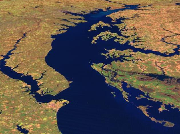
Meanwhile,
University of Maryland researchers used satellite data to judge how
warm the Chesapeake has gotten, and the outlook isn't good. Not only
have average temperatures risen 1.2 degrees per decade since the 1980s,
but there are areas such as Baltimore where it's gotten even worse.
That warming is likely to bring fundamental change to the marine ecology
and exacerbate some of the worst impacts of water pollution such as
"dead zones" and an overall loss of the dissolved oxygen needed to
sustain life underwater..."
Image credit:
NASA Scientific Visualization Studio.
How Do You Make Conservatives Care About Climate Change? An expert has tips at
Grist; here's an excerpt: "...
What
we found is that when you present a message that clearly states the
extent of the consensus — a sentence like “Over 99 percent of climate
scientists are convinced that human-caused climate change is happening,”
when it is represented as coming to them from AAAS [the American
Association for the Advancement of Sciences] — it has a powerful impact on resetting people’s understanding.
Which then has a secondary benefit of making them a little more likely
to believe that climate change is happening. We have found that it is
particularly impactful when resetting conservatives’ beliefs..."
John Kerry Urges Unity on Fighting Climate Change.
The major theme: more climate volatility and water shortages (and
excesses) is already impacting food production; here's an excerpt from
The Wall Street Journal: "...
The
theme of the expo is food security, which Mr. Kerry said is threatened
by climate change. “We cannot have food security if farmers and fishers
around the world are having a more difficult time growing crops,
catching fish, raising livestock—it just doesn’t happen, it won’t
compute,” he said. “The hard truth is that unless the global community
comes together to address climate change, every one of these
challenges—droughts, floods, extreme weather, ocean acidification,
hunger, malnutrition—all of them will only become more pronounced...”
Photo credit above: "
U.S. Secretary of State John Kerry speaks at the Milan Expo on Saturday." Photo: Associated Press.
Voters to GOP: "I'm Not a Scientist" Won't Cut It on Climate Change. Here's an excerpt of an Op-Ed from The L.A. Times: "...We also found that 75% of adults, including 63% of Republicans,
support regulating carbon dioxide as a pollutant. And yet Republicans
have been making the Environmental Protection Agency's Clean Power Plan
their latest punching bag. That may help primary candidates, but it will
cost the GOP in the general election. The most conservative Republicans
— those who oppose climate action — hold sway in primaries. But against
a Democratic candidate, the GOP will have to appeal to a wider audience
to succeed..."
Photo credit above: "
Republican
presidential candidates Marco Rubio and Jeb Bush talk during a break at
this year's first Republican presidential debate in Cleveland." (Andrew Harnik / Associated Press)
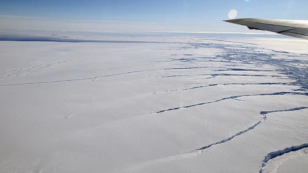
Trouble At The Edge of the World As Antarctica's Glaciers Are Undermined by Warm Water. Here's an excerpt of a story at The Sydney Morning Herald: "...The
overall loss of ice from the Antarctic ice sheet is contested. A NASA
report this month challenged the Intergovernmental Panel on Climate
Change's conclusion that Antarctica is losing 147 billion tonnes a year,
suggesting instead it may have slightly gained overall. Even so, NASA
report author Jay Zwally says losses from the West Antarctic sheet will
likely outweigh East Antarctic gains in a couple of decades. His
colleague, Eric Rignot, says of the key Amundsen Sea sector: "The
collapse of this sector of West Antarctica appears to be unstoppable
... At this point, the end of this sector appears to be inevitable..."
Photo credit above: "Great rifts are visible beneath the wing of a NASA aircraft flying over a glacier feeding the Amundsen Sea." Photo: NASA JPL
Sid Miller Sees Human Role in Climate Change. Here's an excerpt of an article at The Texas Tribune: "Human
actions have contributed to climate change, according to the majority
of climate scientists — and now, apparently, Texas Agriculture
Commissioner Sid Miller.
Asked specifically if he believed human beings have played a role in
climate change, Miller said he's come to believe so, especially after
seeing the level of air pollution in Beijing and Shanghai during a
recent trip to China..."
Photo credit above: Bob Daemmrich. "Agriculture Commissioner Sid Miller at Texas Republican Convention in Fort Worth, June 5th, 2014."
L.A. Times Says Climate Not to Blame for More Wildfires. They're Wrong. Here's a clip from
Mother Jones: "...
In
other words, virtually everyone quoted in this article either (a) says
nothing about climate change or (b) says climate change is an important
factor in the rise of wildfires in California and the West. And yet,
somehow all of this is written in a way that makes it sound as if
climate change has nothing to do with wildfires, and it's topped by a
headline that says in no uncertain terms, "Gov. Brown's link between
climate change and wildfires is unsupported, fire experts say." Very
peculiar."
It's Far Worse Than It Sounds: Climate Change Is Making Our Winters Shorter. Not
every winter, but most winters are trending shorter (as defined by
extreme low temperatures). It may be making winters snowier for coastal
cities, especially New England and Mid Atlantic. A warmer ocean and
atmosphere means more water vapor floating overhead, more fuel for not
only extreme summer rains but heavy winter snows. Here's an excerpt from
Salon: "
If
winter comes… spring’s going to be closer-than-usual behind. New
research shows that as a result of rising temperatures caused by global
climate change, the first leaves and buds of spring will begin arriving
at least three weeks ahead of time in the United States. Researchers at
the University of Wisconsin-Madison examined the variations and trends
in the onset of spring across the Northern Hemisphere’s temperate
regions and calculated that the onset of spring plant growth will shift
by a median of three weeks earlier over the next century. Their findings
were published in the journal Environmental Research Letters yesterday..."
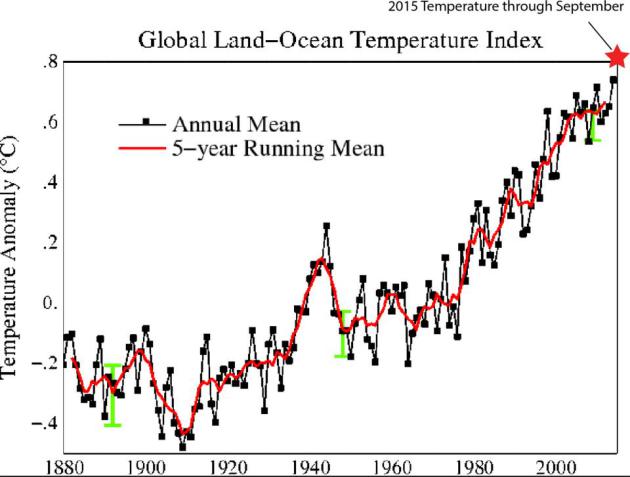
No Warming in 18 Years?
That's one of the popular memes from professional skeptics, but when
you factor oceans (92% of warmth trapped by greenhouse gases goes into
the oceans) the Global Land-Ocean Temperature Index is ever upward and
onward, probably setting a new temperature anomaly record in 2015. Graph
courtesy of Dr. John Abraham at The University of St. Thomas.









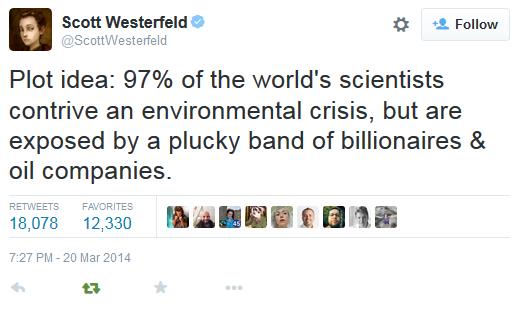
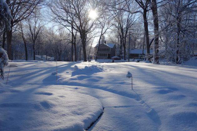
No comments:
Post a Comment