26 F. average high on December 20.
32 F. high on December 20, 2014.
December 21, 1993: Strong northwest winds gust to 35 miles an hour, causing near whiteout conditions over a wide area of southwest Minnesota from the late afternoon on the 21st into the early morning of the 22nd. Several car accidents occurred. A 30 year old man was killed when he lost control of his truck and slid into a ditch in the near blizzard like conditions. Counties affected include: Blue Earth, Brown, Chippewa, Faribault, Lac Qui Parle, Redwood, Renville, Watonwan, and Yellow Medicine.
December 21, 1939: This is the latest date on record for Lake Minnewaska to freeze over at Glenwood.
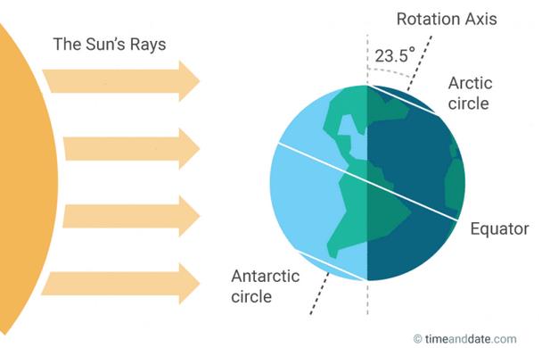
Welcome Winter Solstice! Daylight Drought Peaks
'Tis a joyfully stressful time of year. So much running around, checking lists, trying to exceed expectations. The fog of consumption makes it hard to remember what we're really celebrating.
This festive, manic time of year coincides with the darkest days of the year, which can throw some of us into a deep funk. Only 8 hours and 46 minutes of daylight on today's Winter Solstice.
But December 21 marks a psychological turning point, at least for me. We pick up 3 minutes of daylight by New Year's Eve, another 54 minutes by the end of January!
Today brings the least daylight but the coldest weather of the year usually arrives in mid-January; there's a 3 week lag in the atmosphere.
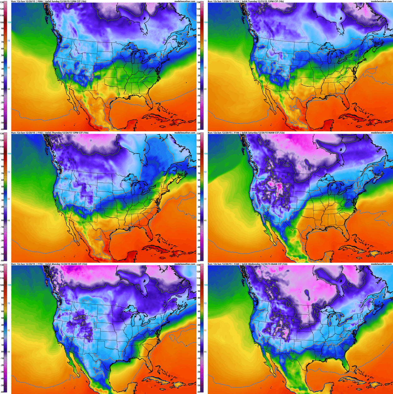
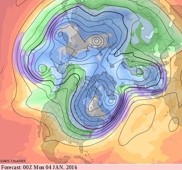
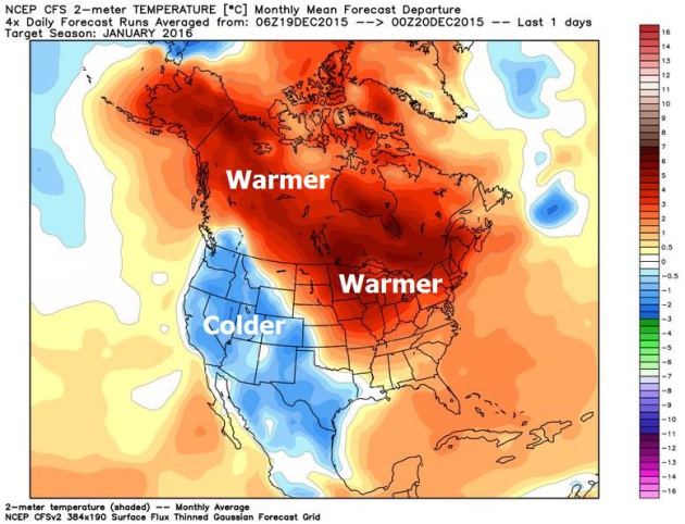
At the rate we're going we may see half a winter this year. We cool slightly today (only 10F warmer than average) but 40F returns midweek. A light mix is possible Wednesday; models hint at wet snow or a mix Saturday. We chill down next week but a warm signal is still overwhelming the pattern.
Tell that to residents of Washington D.C. 70F on Christmas Eve? Santa may show up in a shiny red convertible.
* Graphic above: timeanddate.com.
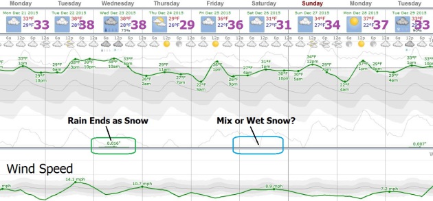
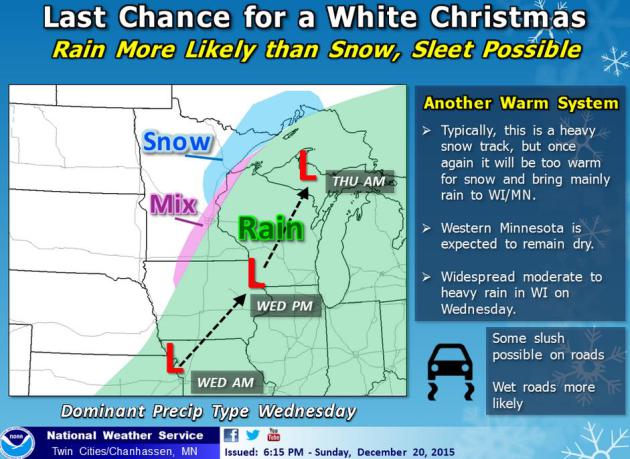
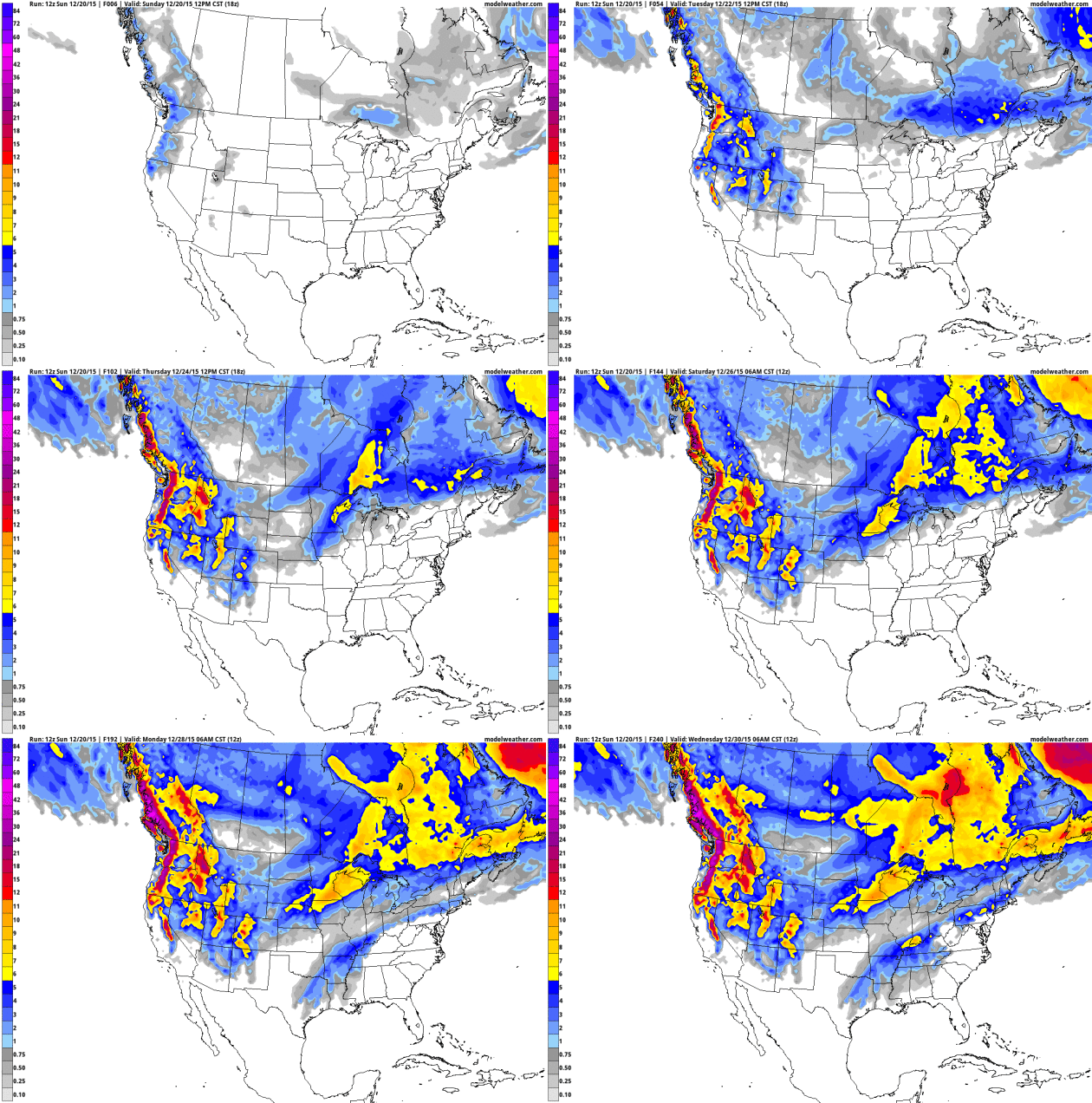

Record-Setting December Continues. It has been a head-scratching month, more March than December. Here's an excerpt from this week's installment of Minnesota WeatherTalk, courtesy of Dr. Mark Seeley: "The December climate pattern across Minnesota is tracking much like November did, warm and wetter, only even more amplified. Average temperature for the month is ranging from 14 to 18 degrees F warmer than normal, and many new warm minimum temperature records have been set such as the low of 38F at MSP and 40F at Rochester on December 13th. On December 14 the temperature never dropped lower than 44F at Caledonia. A high degree of cloudiness has accompanied this warm temperature pattern, fueled by a great deal of water vapor in the air. MSP also set a new high dew point record on December 13th with a reading of 38F. Daily cloud cover has average over 80 percent for the month so far, so little sunshine has made it through..."

December Temperature Anomalies To Date. Over the entire "conus" of North America temperatures are running about 5F warmer than average, but as much as 20F warmer than normal over central Canada. Minnesota is about 14-17F warmer than average as of December 18. Map: WeatherBell.

Which Season is Warming Fastest? The warming signal is showing up most vividly and consistently during the winter months. Here's a clip from Climate Central: "...Even though these are the same areas that tend to have above average temperatures during El Niño winters, this pattern is also consistent with the long-term trend we are seeing with global warming. Winter is the fastest warming season for the majority of the U.S. The exceptions: the Northwest, where fall is warming the fastest; the Southwest where springs are experiencing their greatest rise in temperatures; and Texas, which is pushing it’s sweltering summer heat to a new level..."
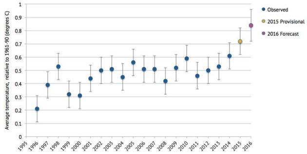
Met Office Forecasts 2016 to be Hottest Year on Record. This, according to the U.K. Met Office; here's an excerpt from CarbonBrief: "Global average temperatures for next year are expected to hit a new high since records began in 1850, says a UK Met Office outlook. At 0.84C above the 1961-90 average, the Met Office says 2016 “is likely to be at least as warm, if not warmer” than 2015. A few weeks ago, the World Meteorological Organisation (WMO) announced
that 2015 is likely to be ranked as the hottest year in modern
observations. Today, the Met Office says 2016 will likely knock it
straight off top spot..."
Graphic credit above: "Global
average temperature (in degrees C) relative to 1961-90 average, for
observed (1996-2014), provisional (2015) and forecast (2016) years.
Error bars are +/- 0.1C for observed and provisional data, and +/- 0.12C
for 2016." Data from WMO and Met Office; chart by Carbon Brief.

Haunted by Waters.
Too much or too little, increased climate volatility is disrupting the
hydrological cycle with troubling implications. You can live without a
lot of things, but water isn't one of them. Here's an excerpt of an
Op-Ed at The New York Times: "...In
some circles, it’s laughable to suggest that global “weirding” is an
international security threat. But in sub-Saharan Africa, where the
desert creeps south, or in Bangladesh, where half the population lives
on ground less than 16 feet above sea level, or in Syria, where extreme
drought was a factor in the collapse of a nation, a warmer earth is
already generating refugees. The Pentagon has warned of coming wars over
water. If self-interest, or fear, is what it takes to motivate a nation
like China to join the world community in saving this troubled little
orb of ours, then so be it. Elsewhere, the prospect of 200 million
people on the move, most of them Muslim, may finally win over that other
block of obstructionists, the Republican Party..."

.jpg)
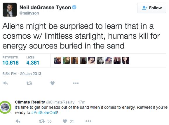
What Just Happened in Solar Is a Bigger Deal than Oil Exports. So says Bloomberg Business; here's a clip: "The clean-energy boom is about to be transformed. In a surprise move, U.S. lawmakers agreed to extend tax credits for solar and wind for another five years. This will give an unprecedented boost to the industry and change the course of deployment in the U.S. The extension will add an extra 20 gigawatts of solar power—more than every panel ever installed in the U.S. prior to 2015, according to Bloomberg New Energy Finance (BNEF). The U.S. was already one of the world's biggest clean-energy investors. This deal is like adding another America of solar power into the mix..." (File photo: Solar City).

Photo credit above: Airline Ratings Historical Collection.


TODAY: Overcast, a bit cooler. Winds: N 8-13. High: 33
MONDAY NIGHT: Clouds linger. Low: 28
TUESDAY: Still gray. Good travel weather. High: 38
WEDNESDAY: Light rain changes to slushy snow. Wake-up: 33. High: 39
CHRISTMAS EVE: Cooler, few fleeting flurries. Winds: W 8-13. Wake-up: 27. High: 31
CHRISTMAS DAY: Cloudy and quiet. Winds: SE 3-8. Wake-up: 24. High: 33
SATURDAY: Chance of a sloppy mix. Winds: NE 10-20. Wake-up: 29. High: 33
SUNDAY: Drying out, better travel day. Winds: NW 7-12. Wake-up: 28. High: 35
Climate Stories...
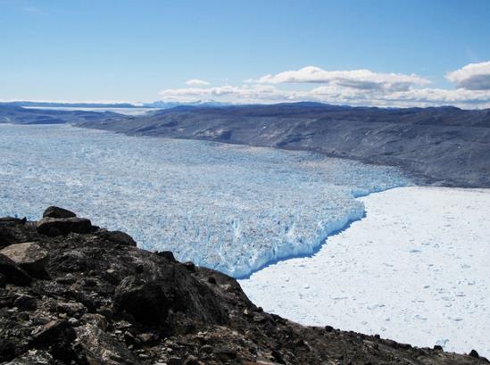
Photo credit above: "Kangiata Nunata Sermia in Southwest Greenland." (Credit: Nicolaj Krog Larsen, Aarhus University, Denmark).
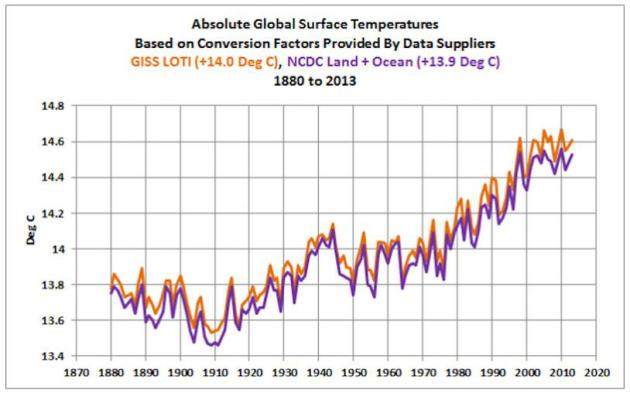
Graphic credit above: "That is a chart from a group of climate-change sceptics. And it shows global warming. Source: Bob Tisdale, WUWT.

Huh? Could Cleaner Air be Worsening Global Warming? Less traditional air pollution, less smog and particulant and sulfer-based haze, we may be inadvertently accelerating the rate of warming, according to new research. Here's an excerpt of a recap at Live Science: "...What's more, this unintentional geoengineering may have already impacted global warming, Wild said. Global temperatures held fairly constant from the 1950s to the 1980s, and warming only accelerated starting in 1985, when the global brightening seems to have begun, Wild reported in a study published this month in the journal WIREs Climate Change. He also sees evidence that this unintentional geoengineering affected the world's hemispheres differently. Temperatures held steady until the mid-1980s in the Northern Hemisphere, where most of the world's population lives, and spiked up sharply afterward..."
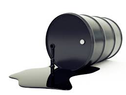
Photo credit: NPR, which has more on the role of sulfer-based pollutants screening warming here.

What Happens When Mother Earth Gets Angry.
There is more carbon in the system, a closed system at that. And that
is translating into more energy, more volatility, more disruption and
dislocation. Here's an excerpt of an Op-Ed at The New York Times: "...In
2009 researchers at the Potsdam Institute, a German research group,
determined that keeping the rise in global temperatures at or below 2
degrees Celsius, the goal set by the United Nations, meant that no more
than 565 additional gigatons of carbon dioxide could be emitted into the
atmosphere. At current levels of global carbon emissions — about 36
gigatons annually — those additional gigatons would be released into the
atmosphere by the early 2030s. Then, in 2011, the Carbon Tracker
Initiative, a British research group, reported that 2,795 gigatons of
carbon was held in the coal, oil and natural gas
reserves of fossil fuel companies and carbon-rich countries. If burned,
the emissions would vastly exceed the ceiling set by the Potsdam
Institute..."
No comments:
Post a Comment