24 F. average high on January 27.
45 F. high on January 27, 2015.
January 28, 2006: A record high temperature of 50 degrees is set at the Eau Claire Regional Airport.
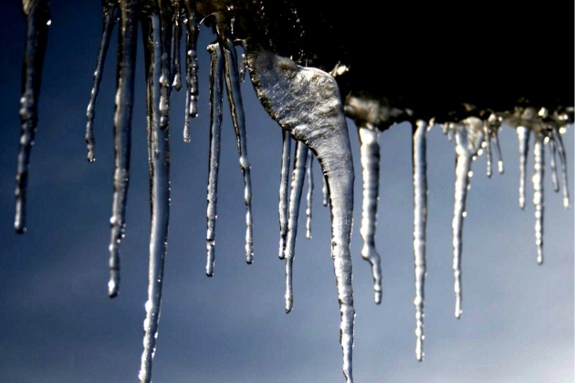
5-Day January Thaw
Hints of a Plowable Snow Next Week?
There is no such thing as a "weather expert". I am reminded, daily, of the depths of my ignorance. Just keeping up with emerging science, new papers, trends and breakthroughs is daunting. So much noise - so little wisdom.
Today's weather blog includes these nuggets: shoveling snow kills or injures an average of 11,500 Americans every winter. Good incentive to remain on the couch and wait for spring.
Hurricane Hunter aircraft probed Saturday's mega-blizzard off the East Coast, trying to "initialize" NOAA's models with better data. Every El Nino is different; NOAA sent a fleet of planes, ships and weather balloons into the Pacific to get a better grasp on how El Nino warm phases may evolve in a warming world.
That same El Nino should, on paper, keep us milder than average into the spring. But there will be spasms of cold and snow though.
Models hint at a sloppy southern storm brushing Minnesota with a potentially plowable snowfall next Tuesday. By late next week highs may be stuck in the teens - so enjoy our 5-day thaw.
January should wind up milder than average. Again.
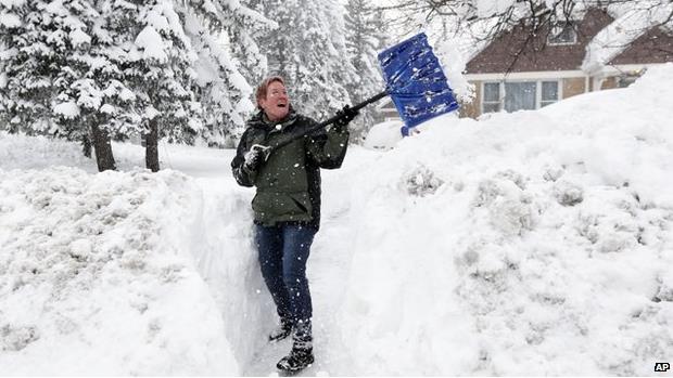

Photo credit above: "Pedestrians push a stroller through heavy snow on the Upper West Side of Manhattan on Saturday morning." Craig Ruttle / AP.
D.C.'s Snow Disasters Have Political Roots. Here's an excerpt of a fascinating story at Politico: "...One
factor is the climate — a border zone that occasionally experiences
frigid winter days rivaling New England, but often skews toward the more
temperate South — which prompts a constant will-it-or-won’t-it guessing
game about snowfall forecasts that are more straightforward in colder
metropolitan areas. (That’s why predicted snowstorms so often turn out
to be rain, sleet or the dreaded “frozen mix.”) Another is the region’s
rapid growth, which hasn’t been accompanied by matching improvements by
the region’s District, state, county and city governments to their
roads, rails and bus systems..."
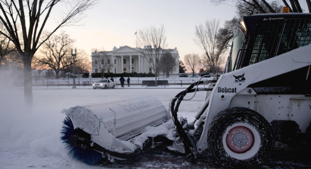
Photo credit above: "A
worker with the National Park Service sweeps snow along Pennsylvania
Avenue in front of the White House in Washington, Thursday, Jan. 21,
2016, after an overnight dusting of snow hit the Washington area." | AP Photo.
Hurricane Hunters Gather Forecast Data on Record-Breaking Blizzard. They've been probing major winter storms for years, and last weekend's East Coast mega-blizzard was another reminder of the critical importance of having better data available to feed the models; here's an excerpt from The U.S. Air Force: "The Hurricane Hunters of the 53rd Weather Reconnaissance Squadron flew a different kind of mission from Keesler Air Force Base Jan. 22 to gather data on the blizzard that hit the Eastern Seaboard. The blizzard began dropping snow on the area early Jan. 22, and was a record-setter for three cities, leaving 29.2 inches in Baltimore, 31.9 inches in Allentown, Pennsylvania, and 34 inches in Harrisburg, Pennsylvania, according to the National Weather Service. The 53rd WRS crew flew along the eastern coast from Florida up to the New York City area over the Atlantic Ocean, dropping sondes ahead of the storm to gather information and to send it back to the NWS, where forecasts and predictions are made..."
Photo credit above: "A 53rd Weather Reconnaissance Squadron WC-130J Hercules, based at Keesler Air Force Base, Miss., flies above the record-setting blizzard the morning of Jan. 23, 2016. The crew gathered data on the storm for the National Weather Service." (U.S. Air Force photo/Staff Sgt. Nicholas Monteleone)
Monster El Nino Probed by Meteorologists.
Every El Nino is different - NOAA researchers are using new tools and
techniques to understand how El Nino warm phases in the Pacific may
evolve in a warming world (and ocean). Here's an excerpt from Nature: "Climate
scientists this week began a research blitz to study El Niño, the
climate trouble-maker that disrupts weather around much of the globe.
For the next two months, US researchers will use specially outfitted
planes, a research ship and hundreds of weather balloons to monitor the
region in the tropical Pacific Ocean where El Niño forms. Ultimately,
the scientists say, their measurements could help to improve weather
forecasts and unlock secrets about how powerful El Niño events evolve..."
Photo credit above: Joel Angel Juárez/AP. "El Niño has sent heavy rains to California this year."
Why January Will Be Milder Than Average.
In spite of the subzero stretch 8-12 days ago we are running just under
1F colder than average, to date, in the Twin Cities. With temperatures
consistently 5-10F warmer than average from today into Sunday we should
end the month slightly warmer than average, overall. A clipper may kick
up a sloppy mix on Friday, maybe an inch or two of slush in the Brainerd
Lakes area, even plowable over the Arrowhead. The approach of
significantly colder air spins up a storm next Tuesday which may result
in plowable amounts of snow - too early for any more specifics. Graphic:
WeatherSpark.
Downhill Slide Next Week.
30s in late January? Grilling weather. Soak up the relative warmth
because much colder air is brewing for the end of next week; I could see
highs in single digits a week from Friday and Saturday. Source: NOAA
and Aeris Enterprise.
NOAA Models Hint at Significant Snow.
1 to 1.7" liquid next Tuesday into Wednesday? It's still premature
barking out inch amounts (ECMWF brushes Minnesota with lesser amounts of
moisture from this next storm) but there's at least a chance of a
(newscast-leading, headline-grabbing) storm next week. You remember
snow, don't you?
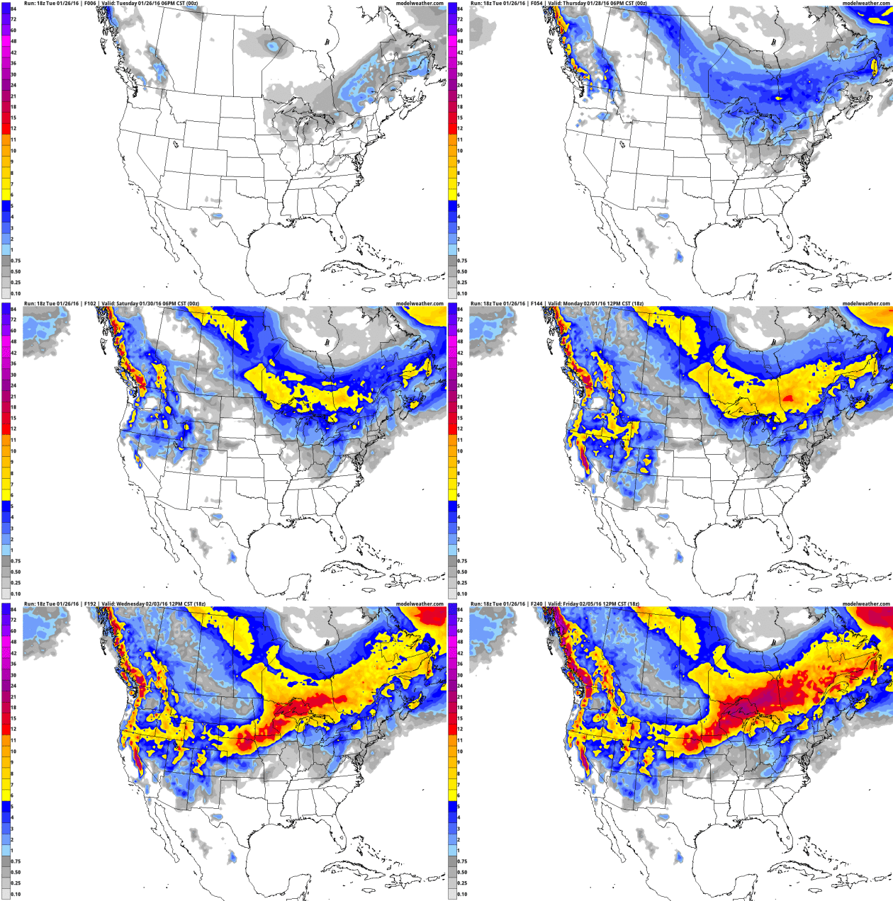
GFS: Snowy Stripe Next Tuesday.
This is a long-range, nearly one-week forecast, so buyer beware. A
weekend clipper drops a few inches of snow on the Minnesota Arrowhead
this weekend, but a moisture-laden southern storm may push a shield of
moderate snow into Minnesota next Tuesday and Wednesday. Stating the
obvious: we're due. Animation: AerisWeather.
GFS Guidance Next Tuesday Evening.
Here is the GFS solution for Tuesday evening at 7 PM, showing a deep
area of low pressure centered over Oklahoma, gulping down Gulf moisture,
pushing wet snow into central and southern Minnesota. NOAA models are
more impressive than ECMWF, but NAM did a great job with the blizzard
last Saturday, so it's good to keep an open mind and track all the
models. Map: WSI.
Moderation Second Week of February.
There's little doubt we'll see a numbing spell of weather around
February 5-7, although I don't believe it will get as cold as it did
earlier this month. GFS 500 mb winds are forecast to be northwest the
evening of February 9, with Minnesota on the eastern fringe of
Pacific-modified air. New England may get slammmed with a significant
snowstorm. Map: GrADS:COLA/IGES.
El Nino Signal to Linger.
Here is the latest NOAA CFSv2 (Climate Forecast System) model for
February and March, showing warm anomalies as much as 5-7F warmer than
average for Minnesota and much of the northern USA and central Canada, a
reflection of a potent, but fading El Nino warming signal in the
Pacific. Map credit: NOAA and WeatherBell.
Ocean Warming Is Making Floods Worse, Study Finds. It will become increasingly difficult to deny rising seas in the years ahead; here's an excerpt from Climate Central: "...Water expands as it heats up, and oceans have been absorbing most of the heat trapped by greenhouse gases released by fossil fuel burning, deforestation and animal farming. A new study blames expansion of warming waters for as much sea level rise from 2002 through 2014 as the melting of all the glaciers and the Greenland and Antarctic ice sheets combined. “Satellite observations show that sea level rise over the last decade is explained, by about 50 percent, by thermal expansion,” said Roelof Rietbroek of the University of Bonn, who led the research, which was published Monday in Proceedings of the National Academy of Sciences..."
Study: Man-Made Heat Put in Oceans Has Doubled Since 1997. Here's the intro to an Associated Press story: "The
amount of man-made heat energy absorbed by the seas has doubled since
1997, a new study says. Scientists have long known that more than 90
percent of the heat energy from man-made global warming goes into the
world's oceans instead of the ground. And they've seen ocean heat
content rise in recent years. But the new study, using ocean-observing
data that goes back to the British research ship Challenger in the 1870s
and including high-tech modern underwater monitors and computer models,
tracked how much man-made heat has been buried in the oceans in the
past 150 years..."
Image credit: earth.nullschool.net.
Oceanic Warming Trend. An estimated 93% of additional heat energy produced by greenhouse gases, mainly CO2, is going into the world's oceans. This not only results in thermal expansion and rising sea levels, but higher water vapor levels, more moisture available for developing storms, especially close to the coast. Graphic above: Larry Hamilton.
Graphic credit above: "The long-term sea level trend in Atlantic City depicts an average rise of 1.34 ft (0.41 m) per 100 years." Credit: NOAA Tides and Currents.
How Much Did El Nino Boost Global Temperature in 2015? Carbon Brief takes a look at new research that tries to provide perspective; here's an excerpt: "Almost as soon as the news broke that 2015 was the hottest year in the modern record, the conversation quickly turned to how much of the record-breaking warmth was down to climate change and how much to the Pacific weather phenomenon known as El Niño. Carbon Brief has spoken to climate scientists working on this question, who all seem to agree El Niño was responsible for somewhere in the region of 10% of the record warmth in 2015. But while the science seems pretty clear, these numbers got somewhat lost in the media coverage..."
Image credit above: "Screenshot of CarbonScanner during the 2013 Boulder floods showing filtered and geolocated tweets captured by scanning application in real time (a), and the alert box generated for which remote-sensing data collection was tasked."

* The NOAA study highlights are here, courtesy of NOAA News.
Solar Panel Costs Set To Fall 10% a Year. In a related story, here's a clip from Climate Home: "Solar power costs are tumbling so fast the technology is likely to fast outstrip mainstream energy forecasts. That is the conclusion of Oxford University researchers, based on a new forecasting model published in Research Policy. Since the 1980s, panels to generate electricity from sunshine have got 10% cheaper each year. That is likely to continue, the study said, putting solar on course to meet 20% of global energy needs by 2027..."
Photo credit above: Lance Cheung/Flickr.
Photo credit above: "A local worker disinfects the famous Sambadrome in Rio de Janeiro, Brazil, on 26 January 2016 in an effort to protect next month’s Carnival parades Zika-carrying mosquitoes." Photograph: Marecelo Sayao/EPA
Photo credit above: "A swarm of locusts in September in the Lavalle area of Santiago del Estero Province, Argentina. Farmers last year reported seeing swarms that were four miles wide and two miles high." Credit SENASA
Image sources: Nebraska Department of Roads.
TODAY: Milder, few flurries. Snowy coating up north. Winds: SW 15-25. High: 36
WEDNESDAY NIGHT: Mostly cloudy. Low: 29
THURSDAY: More clouds than sun, dry. Winds: NW 10-15. High: 33
FRIDAY: Next clipper, sloppy mix? Wake-up: 24. High: 37
SATURDAY: Overcast, drizzle or flurries. Wet roads. Winds: SW 7-12. Wake-up: 31. High: 37
SUNDAY: Mostly cloudy, pretty quiet. Winds: W 8-13. Wake-up: 28. High: 33
MONDAY: Mostly gray, no drama yet. Wake-up: 25. High: 31
TUESDAY: Potential for a few inches of snow. Potentially plowable, especially south/east of MSP. Wake-up: 23. High: 25
Climate Stories...
The state’s Climate Adaptation Partnership Committee (CAP) was formed in 2008. This committee is multi-faceted with representatives from state and federal agencies, the business community, academic institutions, county and municipal units of government, the Science Museum of Minnesota, and NGOs. Our purposes are to improve climate literacy; sponsor, produce, and promote educational resources related to climate change and sustainability; and to host an annual statewide meeting that is dedicated to sharing knowledge and experience related to climate adaptation practices that improve the environment and the quality of life in our state. The annual meeting usually draws 250-350 people and is well covered by the media. More information about CAP, including registration instructions for the Third Annual CAP Conference: "Transforming Awareness Into Action" can be found at this web site:
https://www.wrc.umn.edu/news-
Yes, Actually, Global Warming Probably Helped Supersize This Weekend's Blizzard. Here's a clip from Vice News: "...We expect the Atlantic to continue to warm as we continue to increase greenhouse gas concentrations through fossil fuel burning and other activities," Mann said. "Peer-reviewed scientific studies suggest we are likely to see more of these sorts of coastal storms in the future because of human-caused climate change." In addition to the El Niño, the warm coastal waters may be influenced by a mass of cold water in the North Atlantic. This icy patch south of Greenland contrasts what has otherwise been the warmest year on record and may be the result of freshwater run-off from the country's melting glaciers..."
Graphic credit above: "Sea surface temperature (SST) anomalies for Sunday, January 24 showing very warm water off the East Coast and a cold blob of water south of Greenland. Recent climate research connects the two."
Record Warmth "Almost Certainly" Due To Humans, Scientists Say. Here's a snippet from a Bloomberg Business story: "The odds are “vanishingly small” that recent years of record warmth aren’t due to human emissions of greenhouse gases, researchers in the U.S. and Germany said, adding to pressure on world governments to cut back on fossil fuel use. Thirteen of the 15 warmest years ever recorded were registered through 2014, the researchers at the Potsdam Institute for Climate Impact Research, or PIK, said Monday in the journal Nature. The odds of that occurring naturally range from one in 5,000 to one in 170,000, they wrote. Data showing 2015 is the warmest year ever were published after their study was completed, and would make the odds even slimmer, PIK said in an e-mailed statement..."
Please Stop Saying Humans Aren't Causing Climate Change. Here's a snippet from WIRED: "...The UN World Meteorological Organization (WMO) confirmed on Monday that the global average surface temperature in 2015 shattered all previous records and said 15 of the 16 hottest years on record have all occurred since 2000. “We have reached for the first time the threshold of 1C above pre-industrial temperatures. It is a sobering moment in the history of our planet,” said WMO secretary-general Petteri Taalas..."
Image credit above: "A map of temperature anomalies in 2015 compared to the long-term average." NASA
Photo credit above: "Two young boys walk along the boardwalk in the village of Newtok, Alaska in October of 2004." (Jedediah R. Smith / For the Times).
.jpg)
Climate's First Big Hurdle: The Draw of Cheap Oil. The New York Times takes a look at the implications of the current oil glut; here's the intro: "Barely a month after world leaders signed a sweeping agreement to reduce carbon emissions, the global commitment to renewable energy sources faces its first big test as the price of oil collapses. Buoyed by low gas prices, Americans are largely eschewing electric cars
in favor of lower-mileage trucks and sport utility vehicles. Yet the
Obama administration has shown no signs of backing off its requirement
that automakers nearly double the fuel economy of their vehicles by 2025..."
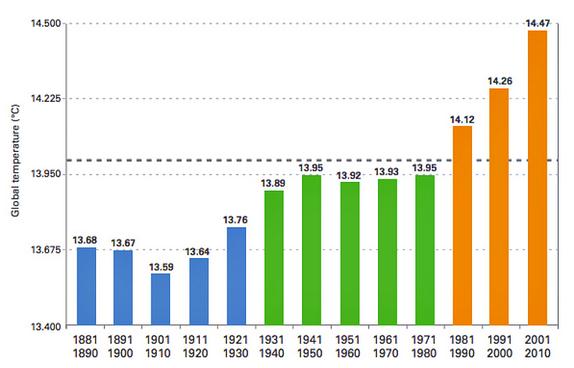
Graphic credit above: "Historical Northern Hemisphere mean-temperatures (black solid line) along with the estimated natural component alone (black dashed line) and five of the surrogates (colored curves) for the natural component. Temperature departures are defined relative to the long-term 1880 to 2015 average."
Rapid, Affordable Energy Transformation Possible, Study Says. A story at phys.org made me do a triple-take; here are a couple of excerpts: "The United States could slash greenhouse gas emissions from power production by up to 78 percent below 1990 levels within 15 years while meeting increased demand, according to a new study by NOAA and University of Colorado Boulder researchers..."Our research shows a transition to a reliable, low-carbon, electrical generation and transmission system can be accomplished with commercially available technology and within 15 years," said Alexander MacDonald, co-lead author and recently retired director of NOAA's Earth System Research Laboratory (ESRL) in Boulder...
Map credit above: "A high-resolution map based on NOAA solar irradiance data showing one measure of solar energy potential across the United States." Credit: Chris Clack/CIRE.
A
high-resolution map based on NOAA solar irradiance data showing one
measure of solar energy potential across the United States. Credit:
Chris Clack/CIRE
Read more at: http://phys.org/news/2016-01-rapid-energy.html#jCp
Read more at: http://phys.org/news/2016-01-rapid-energy.html#jCp
A
high-resolution map based on NOAA solar irradiance data showing one
measure of solar energy potential across the United States. Credit:
Chris Clack/CIRE
Read more at: http://phys.org/news/2016-01-rapid-energy.html#jCp
Read more at: http://phys.org/news/2016-01-rapid-energy.html#jCp
The
United States could slash greenhouse gas emissions from power
production by up to 78 percent below 1990 levels within 15 years while
meeting increased demand, according to a new study by NOAA and
University of Colorado Boulder researchers.
Read more at: http://phys.org/news/2016-01-rapid-energy.html#jCp
Read more at: http://phys.org/news/2016-01-rapid-energy.html#jCp

We Just Had The Hottest Year on Record. Where Does That Leave Climate Denial? Cue the conspiracy theories. Here's a clip from The Conversation: "...Enter denial strategy two: that if every scientific agency around the world agrees on global warming, they must be engaging in a conspiracy! Far from being an incidental ornament, conspiratorial thinking is central to denial. When a scientific fact has been as thoroughly examined as global warming being caused by greenhouse gases or the link between HIV and AIDS, then no contrary position can claim much intellectual or scholarly respectability because it is so overwhelmingly at odds with the evidence. That’s why politicians such as Republican Congressman Lamar Smith need to accuse the NOAA of having “altered the [climate] data to get the results they needed to advance this administration’s extreme climate change agenda”. If the evidence is against you, then it has to be manipulated by mysterious forces in pursuit of a nefarious agenda..."
Graph credit: "Satellite data (green) has much more uncertainty than thermometer records (red)." Kevin Cowtan / RSS / Met Office HadCRUT4, Author provided.
No comments:
Post a Comment