Thursday Severe Weather Recap
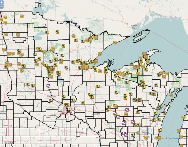
Here's
a quick look at all the wind reports across Minnesota and into
Wisconsin and the U.P. of Michigan from the squall line that moved
through the region early Thursday morning. The top wind report was 83
mph recorded in Hallock, and a 69 mph wind gust was reported at the
Duluth airport. You can read more about the squall line Thursday morning
from the NWS Duluth office.
Meanwhile, many are without power still across northern Minnesota, but crews are making progress. Read more from the Duluth News Tribune.
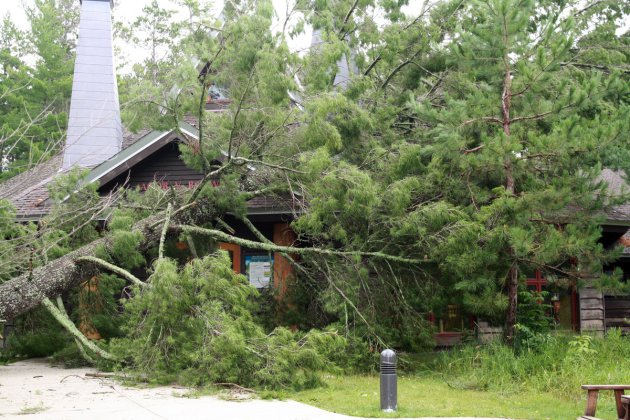
Photo: Minnesota DNR
Some
Minnesota state parks and recreation areas sustained damage in the
storms Thursday. This was a tree down in front of the Jacob V. Brower
Visitor Center in Itasca State Park. According to the Minnesota DNR as
of earlier on Friday, "Itasca State Park campgrounds are open and
most lodging facilities will reopen at 4 p.m. Saturday, July 23. There
are still some temporary closures of remote campsites, group camps and
lodging facilities. Visitors affected by the closures are being
contacted by the DNR. An emergency crew of about 30 is on-site cutting
downed trees, cleaning up debris and making trails passable. The park is
gradually opening facilities as areas are being cleared of downed trees
and debris. Check the Itasca State Park page for the most current
conditions. Douglas Lodge restaurant will reopen on Saturday. The Jacob
V. Brower Visitor Center and Wilderness Drive continue to be closed and
Itasca’s phone system is still down."Read more about other state parks and recreation areas damaged in the storm at the Minnesota DNR website. View more damage photos from Itasca State Park on the Minnesota DNR facebook page.
Here
was what some of the storm damage looked like in the Hill City area, as
captured by NWS Duluth senior meteorologist Amanda Graning.
Meanwhile,
not even the NWS Duluth office could escape the storms. NWS Duluth
meteorologist Joe Moore shared this picture of a tree snapped in front
of the office.
________________________________________________
Dew Points Friday Afternoon
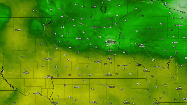
Dew Point temperatures at 4 pm Friday. Map: Aeris Weather.
While
we were able to mix some drier air in on Friday across the Twin Cities,
those across southern Minnesota weren't as lucky. Here were the dew
points at 4 pm - it was as high as 80 degrees at the Rochester airport!
________________________________________________
July 23-24, 1987 Flooding
This
year marks the 29th anniversary of the 1987 flooding across the Twin
Cities, which brought much of the metro very heavy rain. The Twin Cities
airport picked up 10" of rain over the two days, 9.15" of that falling
on the 23rd. That day goes down in history as the wettest day in Twin
Cities history. Here's some more information on the heavy rain from
climate historian Tom St. Martin that the Minnesota Climatology Working
Group posted a few years ago on the 25th anniversary:
_______________________________________________
Risk of Acronyms - Severe Saturday, Then Cooler
By: Paul Douglas
When
it comes to acronyms meteorology is even worse than the military: NOAA
SPC has a svr risk today, with a good chance of an MCS system. NDFD data
hints at low 90s before severe storms bubble up; NOAA's 4km NAM shows
an afternoon CAPE of 5000 with a LI (lifted index) of -11. You get the
idea. It's probably like this in every business, but get two nerdy
meteorologists babbling about the weather and you may need subtitles.
Today
should be the 4th day in a row of 90s; the last day of our July
heat-wave. Dew points in the 70s will fuel today's thunderstorm
outbreak, and once again I could see straight-line winds in excess of
60-70 mph. The best chance of running and screaming comes between 4-9 pm. Keep an eye on the sky and your smart phone, and always scope out a nearby shelter, just in case. Winds swing to the west Sunday with more sunshine and lower humidity - the nicer day of the weekend for the lake.
A beautiful Monday gives way to scattered showers and T-showers Tuesday into Friday as temperatures cool. With luck we may salvage warm sunshine next weekend, without any 90s.
________________________________________________
Extended Forecast for Minneapolis
SATURDAY: PM severe storm risk. High 91. Low 68. Chance of precipitation 80%. Wind SE 10-20 mph.
SUNDAY: Partly sunny, breezy, less humid. High 85. Low 67. Chance of precipitation 10%. Wind NW 10-15 mph.
MONDAY: Blue sky, best day in sight. High 86. Low 70. Chance of precipitation 0%. Wind W 5-10 mph.
TUESDAY: Less sun, risk of a T-storm. High 85. Low 69. Chance of precipitation 30%. Wind SW 8-13 mph.
WEDNESDAY: AM sunshine, few PM storms pop up. High 83. Low 68. Chance of precipitation 30%. Wind SE 7-12 mph.
THURSDAY: Still unsettled, scattered T-showers. High 82. Low 66. Chance of precipitation 30%. Wind SE 10-15 mph.
FRIDAY: Showers and T-storms linger. High 79. Low 63. Chance of precipitation 50%. Wind NE 10-15 mph.
Sunset: 8:49 PM
*Length Of Day: 15 hours, 00 minutes and 3 seconds
*Daylight Lost Since Yesterday: ~2 mins & 2 secs
*Next Sunrise That Is Before 6 AM: August 3rd (6:01 AM)
*Next Sunset That Is Before 8:30 PM: August 8th (8:29 PM)
SUNDAY: Partly sunny, breezy, less humid. High 85. Low 67. Chance of precipitation 10%. Wind NW 10-15 mph.
MONDAY: Blue sky, best day in sight. High 86. Low 70. Chance of precipitation 0%. Wind W 5-10 mph.
TUESDAY: Less sun, risk of a T-storm. High 85. Low 69. Chance of precipitation 30%. Wind SW 8-13 mph.
WEDNESDAY: AM sunshine, few PM storms pop up. High 83. Low 68. Chance of precipitation 30%. Wind SE 7-12 mph.
THURSDAY: Still unsettled, scattered T-showers. High 82. Low 66. Chance of precipitation 30%. Wind SE 10-15 mph.
FRIDAY: Showers and T-storms linger. High 79. Low 63. Chance of precipitation 50%. Wind NE 10-15 mph.
_______________________________________________
This Day in Weather History
July 23rd
July 23rd
1987: The greatest deluge ever recorded begins in the Twin Cities, with 10 inches of rain in six hours at MSP airport.
_______________________________________________
Average Temperatures & Precipitation for Minneapolis
July 23rd
July 23rd
Average High: 83F (Record: 105F set in 1934)
Average Low: 64F (Record: 47F set in 1876)
Average Precipitation: 0.12" (Record: 9.15" set in 1987)
_______________________________________________
Average Low: 64F (Record: 47F set in 1876)
Average Precipitation: 0.12" (Record: 9.15" set in 1987)
_______________________________________________
Sunrise/Sunset Times for Minneapolis
July 23rd
Sunrise: 5:49 AMJuly 23rd
Sunset: 8:49 PM
*Length Of Day: 15 hours, 00 minutes and 3 seconds
*Daylight Lost Since Yesterday: ~2 mins & 2 secs
*Next Sunrise That Is Before 6 AM: August 3rd (6:01 AM)
*Next Sunset That Is Before 8:30 PM: August 8th (8:29 PM)
________________________________________________
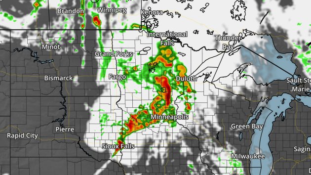
Forecast radar and satellite from the NAM 4k at 5 PM Saturday.
If
you are heading out to the Aquatennial fireworks Saturday night, you
will want to keep an eye on the weather. By the afternoon hours, a warm
front will have lifted north across central Minnesota increasing
moisture and instability. A cold front will be coming in behind it by
the evening, sparking off strong to severe storms that will form into a
line and quickly move east. A few of the storms, especially early on,
will be capable of large hail, damaging winds and a tornado or two. Once
the line forms, damaging winds will become the main threat.
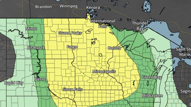
A Slight Risk of severe weather (in yellow) is in place across much of the state Saturday due to this threat.
Heavy
rain will also be a concern with these storms. There is the potential
parts of central Minnesota could end up with 1-2"+ Saturday into
Saturday Night.
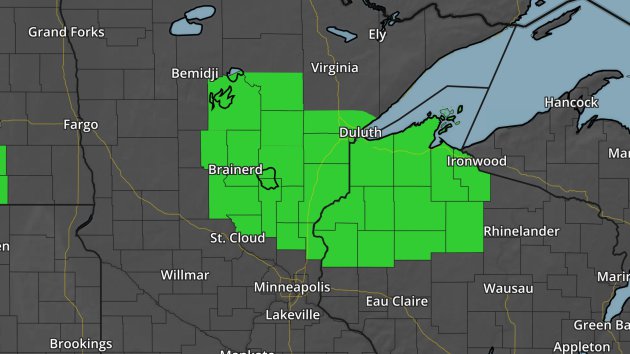
Due
to the favorable environment tomorrow for a heavy rain threat, combined
with the recent heavy rain, a Flash Flood Watch has been issued for
areas north of the metro, including Brainerd, Duluth, Hinckley and
Foley. This is in effect from Saturday afternoon through Sunday morning.
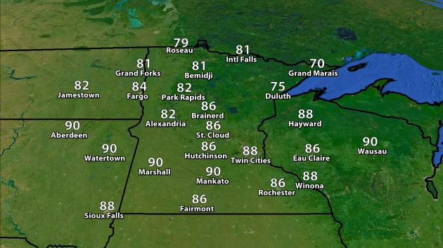
Highs will be a touch cooler across the region Saturday, with highs only around 90 here in the Twin Cities.
________________________________________________
Saturday National Forecast Outlook
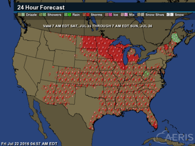
Looking
nationally, we'll also be watching the potential of scattered storms
across parts of the eastern U.S. and in the Southwest.
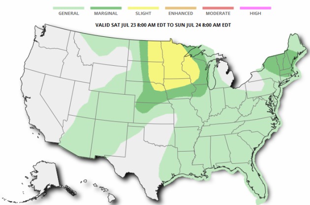
Besides
the severe threat across the North Central U.S. (including Minnesota),
there is a Marginal Threat of severe weather across parts of New
England. Isolated damaging winds and hail would be the main threat.
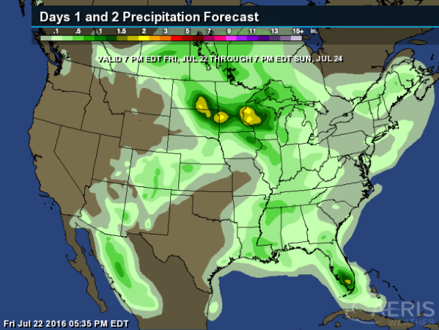
Heavy rain will also be possible in parts of the Southeast as we go through the weekend, with the potential of 1-2" of rain.
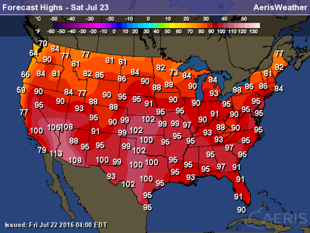
Record
heat is possible in the Southwest Saturday, and 100s will be possible
in the central Plains as far north as Kansas. Heat will also continue to
spread into the Northeast, with highs into the mid/upper 90s as far
north as the New York City area.
________________________________________________
Thanks for checking in and have a great Saturday! Don't forget you can follow me on Twitter (@dkayserwx) or on Facebook (Meteorologist D.J. Kayser)!-D.J. Kayser

No comments:
Post a Comment