Saturday Late Morning/Early Afternoon Severe Storms
Yellow dot = wind damage/gust.
Storms
rolled through the metro area during the late morning/early afternoon
hours with strong wind gusts, knocking down some trees and power lines.
There was a 52 mph wind gust reported 8 miles SSE of Cannon Falls, and a
48 mph wind gust 2 miles west of Bay City, WI.
Very
heavy rain also fell just north of the metro with storms, including 5"
reported in the Howard Lake area, 4.50" in Ramsey, and 3.75" in
Monticello.
_______________________________________________
Guiding A Ship Through 80-100+ mph Winds
As
the severe storms blew through Duluth early Thursday morning, the
Algoma Guardian was just entering the Duluth ship canal. The Duluth News Tribune
has the story of how the captain of the ship prevented it from going
into the side of the canal, and of the bridge operator who had to ride
out the wind at the top of the structure. Of note, the bridge's wind
gauge saw a peak gust of 80 mph, but the Algoma Guardian saw a peak gust
of 103 mph. Here a clip from the beginning of the story: "A
729-foot freighter was making its way through the Duluth ship canal when
the winds began to howl early Thursday. As the strong straight-line
winds from severe storms began to quickly turn the Algoma Guardian
sideways in the canal, Capt. Monford Organ's main concern was getting
the freighter into the Duluth Harbor Basin without any damage."
Dennis O'Hara posted on YouTube the webcam footage
of the Algoma Guardian going through the Duluth canal and under the
bridge early Thursday morning, which is where the above image comes
from.
_______________________________________________
July 23-24, 1987 Flooding
This
year marks the 29th anniversary of the 1987 flooding across the Twin
Cities, which brought much of the metro very heavy rain. The Twin Cities
airport picked up 10" of rain over the two days, 9.15" of that falling
on the 23rd. That day goes down in history as the wettest day in Twin
Cities history. Here's some more information on the heavy rain from
climate historian Tom St. Martin that the Minnesota Climatology Working
Group posted a few years ago on the 25th anniversary:
_______________________________________________
129° In The Middle East
3 PM (local time) temperatures Friday. Map: Aeris Weather.
Think it has been hot here recently? The thermometer hit 129 in at least two Middle East locations last Thursday and Friday. The Capital Weather Gang has more: "The
temperature in Mitribah, Kuwait, surged Thursday to a blistering 129.2
degrees (54 Celsius). And on Friday in Basra, Iraq, the mercury soared
to 129.0 degrees (53.9 Celsius). If confirmed, these incredible
measurements would represent the two hottest temperatures ever recorded
in the Eastern Hemisphere, according to Weather Underground
meteorologist Jeff Masters and weather historian Christopher Burt, who
broke the news."
_______________________________________________
Free Solar Energy Returns Today - 80s This Week
By Paul Douglas
By Paul Douglas
Don't
think the atmosphere and oceans are warming? Acknowledge the science -
or don't. We may disagree on the severity of the problem, but I suspect
we might agree on a solution.
We
need more energy, want to pay less, with fewer unpleasant side effects
and dependencies. The cost of solar is dropping faster than the price at
the pump.
Citizens League is hosting a clean energy conference in Minneapolis on Monday,
focused on conservative, economy-empowering solutions. "The pace of
decarbonization is ultimately going to be driven by economics, not
politics" said David Strom.
The swarm of severe, flooding thunderstorms, the sprawling "MCS system" that fouled up your Saturday plans, gives way to a drying northwest breeze today. The sun comes out with mid-80s and a dew point in the 60s. A salvageable Sunday!
The
good news: the heat wave is history, at least looking out 2-3 weeks. No
more sultry 90s, but instability T-showers may sprout each afternoon
from Tuesday into next weekend.
With flooded basements and downed trees, many of us could use a break. It arrives today.
_______________________________________________
Extended Forecast for Minneapolis
SUNDAY: Partly sunny, warm. High 86. Low 65. Chance of precipitation 10%. Wind NW 10-15 mph.
MONDAY: As good as it gets. Bright sunshine. High 85. Low 69. Chance of precipitation 0%. Wind NW 5-10 mph.
TUESDAY: Sunny start, late T-storm risk. High 89. Low 70. Chance of precipitation 30%. Wind S 8-13 mph.
WEDNESDAY: Unsettled, showers and T-storms. High 84. Low 68. Chance of precipitation 50%. Wind SE 8-13 mph.
THURSDAY: Instability showers & storms linger. High 79. Low 67. Chance of precipitation 70%. Wind NE 7-12 mph.
FRIDAY: Peeks of sun, passing shower. High 80. Low 66. Chance of precipitation 50%. Wind NE 5-10 mph.
SATURDAY: Ditto. AM sun, few PM T-storms. High 81. Low 65. Chance of precipitation 60%. Wind E 5-10 mph.
Sunset: 8:48 PM
*Length Of Day: 14 hours, 57 minutes and 58 seconds
*Daylight Lost Since Yesterday: ~2 mins & 5 secs
*Next Sunrise That Is Before 6 AM: August 3rd (6:01 AM)
*Next Sunset That Is Before 8:30 PM: August 8th (8:29 PM)
Sunday And Beyond Minnesota Weather Outlook
MONDAY: As good as it gets. Bright sunshine. High 85. Low 69. Chance of precipitation 0%. Wind NW 5-10 mph.
TUESDAY: Sunny start, late T-storm risk. High 89. Low 70. Chance of precipitation 30%. Wind S 8-13 mph.
WEDNESDAY: Unsettled, showers and T-storms. High 84. Low 68. Chance of precipitation 50%. Wind SE 8-13 mph.
THURSDAY: Instability showers & storms linger. High 79. Low 67. Chance of precipitation 70%. Wind NE 7-12 mph.
FRIDAY: Peeks of sun, passing shower. High 80. Low 66. Chance of precipitation 50%. Wind NE 5-10 mph.
SATURDAY: Ditto. AM sun, few PM T-storms. High 81. Low 65. Chance of precipitation 60%. Wind E 5-10 mph.
_______________________________________________
This Day in Weather History
July 24th
July 24th
1987: A
historic deluge ends in the Twin Cities. Two-day totals include over a
foot of rain at Bloomington. Nearly 10 inches falls in downtown
Minneapolis, and near 9 inches is recorded in St. Paul. At one time the
water reaches a depth of 13.5 feet on I-494 near East Bush Lake Road.
I-494 in Bloomington would be closed for nearly 5 days.
1891: Heavy
frost hits Elkton in Mower County in southeast Minnesota. The frost
kills all vegetable crops. The low in Elkton is 34, and the Twin Cities
have a low of 49.
_______________________________________________
Average Temperatures & Precipitation for Minneapolis
July 24th
July 24th
Average High: 83F (Record: 104F set in 1941)
Average Low: 64F (Record: 49F set in 1891)
Average Precipitation: 0.14" (Record: 1.69" set in 2012)
________________________________________________
Average Low: 64F (Record: 49F set in 1891)
Average Precipitation: 0.14" (Record: 1.69" set in 2012)
________________________________________________
Sunrise/Sunset Times for Minneapolis
July 24th
Sunrise: 5:50 AMJuly 24th
Sunset: 8:48 PM
*Length Of Day: 14 hours, 57 minutes and 58 seconds
*Daylight Lost Since Yesterday: ~2 mins & 5 secs
*Next Sunrise That Is Before 6 AM: August 3rd (6:01 AM)
*Next Sunset That Is Before 8:30 PM: August 8th (8:29 PM)
________________________________________________
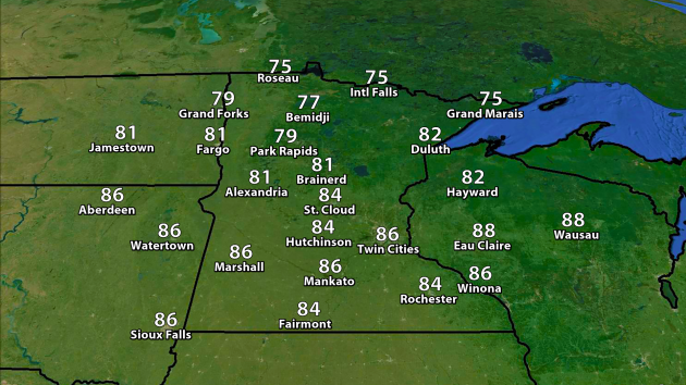
We'll
see temperatures a little cooler Sunday behind the cold front, with
highs only making it into the mid 80s here across the Twin Cities.
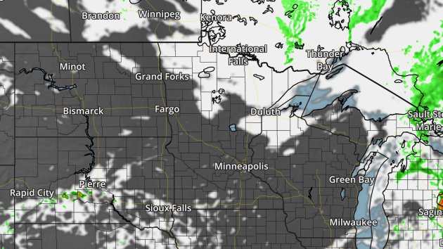
4km NAM forecast clouds and precipitation for 1 PM Sunday. Map: Aeris Weather.
The
good news is that Sunday will be much calmer across Minnesota with
mainly sunny skies expected across the southern portions of the state. A
few more clouds can be expected across northern Minnesota.
Looking
into the future, temperaturewise, our weather models are hinting at a
little cool down as we head into late this week, with highs nearing 80
by next Friday/Saturday. However, the long term forecast shows the
signal of potentially another heat burst as we head into the first week
of August. This bears watching over the next week or so to see if it
sticks around in the models or fades away.
________________________________________________
National Forecast Outlook

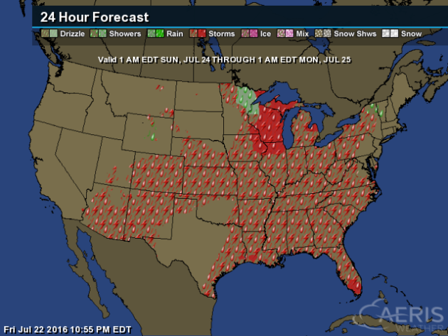
Storms
will be possible in the central Plains and Ohio Valley along a cold
front moving through the region - the same one that brought Minnesota
storms Saturday. A weak upper level low will bring the chance of some
showers and storms to parts of the Southeast. Some storms will also be
possible in parts of the Southwest. Some of the storms over the upper
Great Lakes and the central High Plains could be strong to severe, with
hail and wind the main threats.
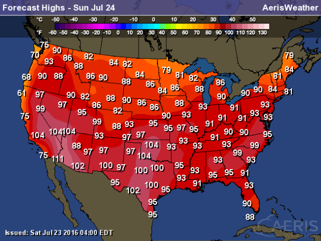
Much
of the nation will be warm on Sunday, with highs in the 80s expected in
each state across the lower 48. 90s will be possible as far north as
parts of Nebraska to the New York City area.
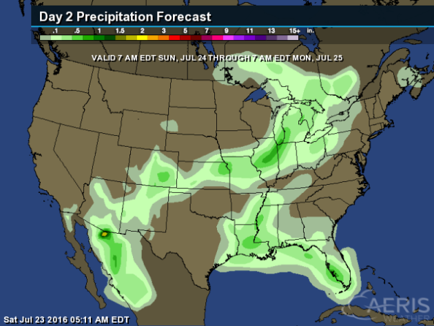
The
heaviest rain Sunday will be across central parts of the U.S., where 1"
or more will be possible. More rain is possible across parts of the
Gulf Coast, with the potential of at least a half an inch.
________________________________________________
Thanks for checking in and have a great Sunday! Don't forget you can follow me on Twitter (@dkayserwx) or on Facebook (Meteorologist D.J. Kayser)!-D.J. Kayser

No comments:
Post a Comment