Cool, Wet August Across Minnesota
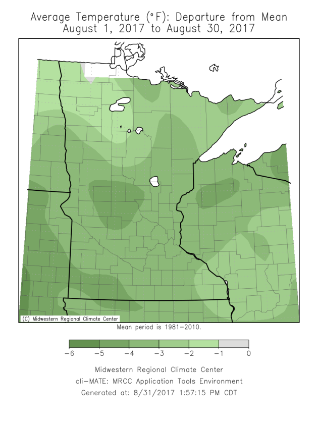
August
2017 will go down as a cool than average month across the state of
Minnesota. Some of the coolest weather was in the central and
southwestern parts of the state, with temperatures a good 2-4 degrees
below average for the month. The Twin Cities will end the month a little
under two degrees below average.
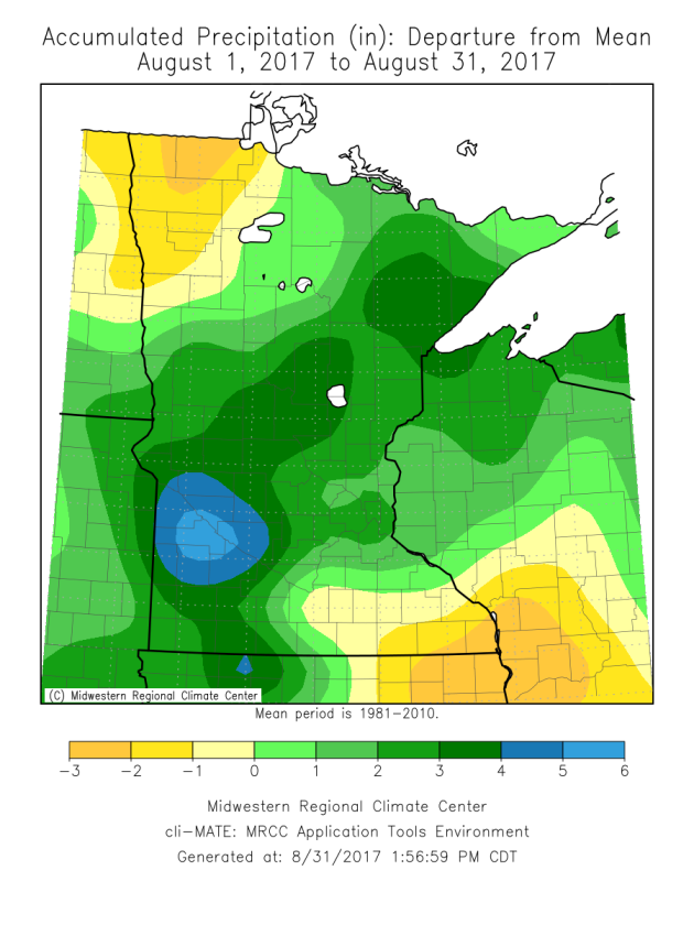
It was also a wet month across a good portion of the state. Of course, we saw the heavy rain of August 16-17
across parts of southwestern Minnesota, which helped the Redwood Falls
area see a rainfall departures of 4"+ in August. The above average rain
could be found from southwest to northeast Minnesota, with above
rainfall departure amounts tapering off on either side. The Twin Cities
will end the month about 2.50" above average in the rainfall
department. We still saw below average rainfall across parts of
northwest and southeast Minnesota.
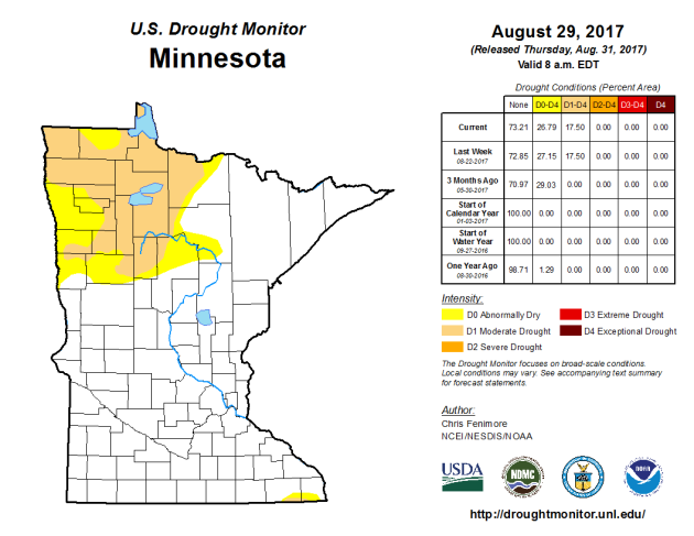
Because
of that, we still have Moderate Drought across parts of northwestern
Minnesota. Officially, 26.8% of the state is abnormally dry, with 17.5%
of the state in Moderate Drought.
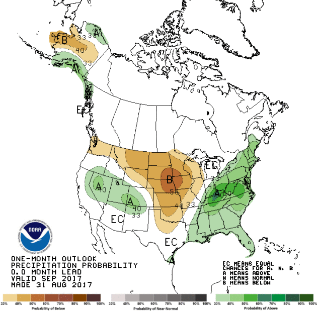
Unfortunately
the latest one-month outlook from the Climate Prediction Center is
calling for below average precipitation across Minnesota during the
month of September, so we might not have much of an opportunity to see
that drought start to fade away.
_______________________________________________
Meteorological Miracle: Nice Holiday Weather?
By Paul Douglas
By Paul Douglas
As
you plan your weekend activities please remember Murphy's Third Law:
"Storms, given a choice, PREFER to come on weekends and major holidays."
Of course it's all perception. We tend to be outside on weekends; more
weather-aware, more likely to gripe when the sky begins to leak.
August
was about 2.3F cooler than average in the Twin Cities, but
meteorological summer (June, July and August) was warmer and wetter than
average. Farmers would like an extended warm period for crops to mature
and fill out. That's coming, but not until the second & third week
of September, when an extended period of 80s returns.
In
the meantime a shower or T-shower is possible tonight into midday
Saturday. Sunday looks like the best day of the holiday weekend: 80s,
sunny and dry. A much cooler front arrives Labor Day with gusty
northwest winds & showers sprouting up north. By the middle of next
week Canadian air engulfs the state: 60s for highs south; 50s up north
with an early-season frost possible.
I'd bet a (stale) corn dog September will be warmer than average. Don't write summer off just yet.
_______________________________________________
Extended Twin Cities Forecast
FRIDAY: Partly sunny, mild. High 73. Low 59. Chance of rain 20%. Wind SE 8-13 mph.
SATURDAY: Morning T-storm, then clearing. High 78. Low 63. Chance of rain 50%. Wind SW 7-12 mph.
SUNDAY: Sunnier, drier warmer. Best day. High 85. Low 64. Chance of rain 10%. Wind W 7-12 mph.
MONDAY: Windy & cooler. PM showers up north. High 73. Low 54. Chance of rain 30%. Wind NW 10-20 mph.
TUESDAY: More clouds than sun, brisk. High 67. Low 48. Chance of rain 20%. Wind NW 8-13 mph.
WEDNESDAY: Sunny, comfortably cool. High 69. Low 50. Chance of rain 10%. Wind W 5-10 mph.
THURSDAY: Blue sky, beautiful weather. High 75. Low 53. Chance of rain 10%. Wind SW 5-10 mph.
_______________________________________________
This Day in Weather History
September 1st
1926:
Perhaps the most intense rainfall rate ever in downtown Minneapolis
falls on this date. 1.02 inches of rain is recorded in six minutes,
starting at 2:59pm in the afternoon according to the Minneapolis Weather
Bureau. The deluge, accompanied with winds of 42 mph, causes visibility
to be reduced to a few feet at times and stops all streetcar and
automobile traffic. At the intersection of Second and Sixth Streets in
downtown Minneapolis, rushing water tears a manhole cover off, and a
geyser of water shoots 20 feet in the air. Hundreds of wooden paving
blocks are uprooted and float onto neighboring lawns, much to the
delight of barefooted children seen scampering among the blocks after
the rain ends.
1894:
The Great Hinckley Fire. Drought conditions start a massive fire that
begins near Mille Lacs and spreads to the east. The firestorm destroys
Hinckley and Sandstone and burns a forest area the size of the Twin
Cities Metropolitan Area. Smoke from the fires brings shipping on Lake
Superior to a standstill.
1807:
The earliest known comprehensive Minnesota weather record begins near
Pembina. The temperature at midday is 86 degrees, with a 'strong wind
until sunset.'
_______________________________________________
Average Temperatures & Precipitation for Minneapolis
September 1st
Average High: 77F (Record: 97F set in 1913)
Average Low: 59F (Record: 36F set in 1974)
Average Precipitation: 0.12" (Record: 3.29" set in 1942)
________________________________________________
Sunrise/Sunset Times for Minneapolis
September 1st
Sunrise: 6:35 AM
Sunset: 7:49 PM
*Length Of Day: 13 hours, 14 minutes and 2 seconds
*Daylight Lost Since Yesterday: ~3 minutes
*Next Sunrise At/After 7 AM: September 22nd (7:00 AM)
*Next Sunset At/Before 7:30 PM: September 11th (7:30 PM)
_______________________________________________
Minnesota Weather Outlook
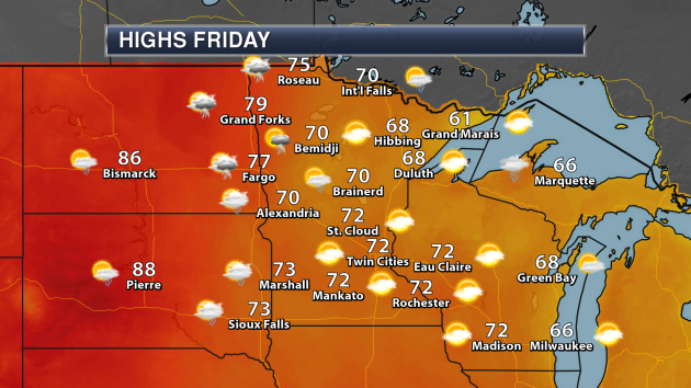
A
few showers and storms will be possible during the daytime hours across
western Minnesota Friday, otherwise a mix of clouds and sun are
expected across the rest of the state. Highs will be in the 70s for most
locations, but 60s are likely across parts of north-central and
northeastern Minnesota.

Across the state highs will mainly be below average for this time of year by up to approximately 5 degrees.

We
will see a warm up as we head into the weekend part of the
extended Labor Day weekend, with highs reaching the low 80s by Sunday. A
cold front moves through on Monday, however, dropping temperatures for
the middle of next week.
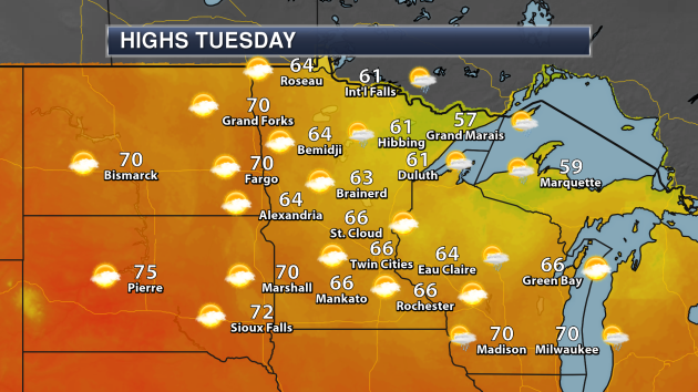
Refreshing
air will be in place next Tuesday for kids going back to school, with
most areas of the state not making it out of the 60s for highs. A few
showers will be possible across the Arrowhead.
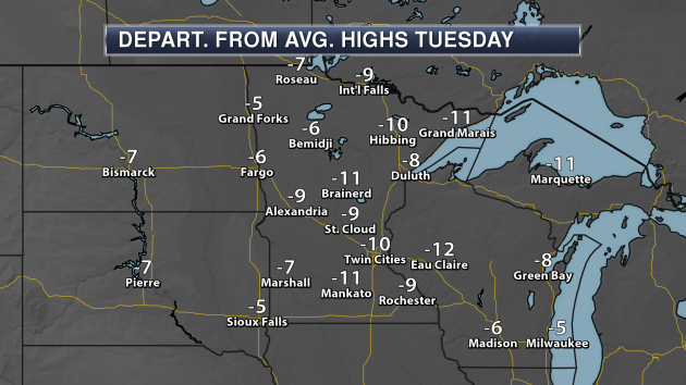
Highs
on Tuesday will be between 5 to 15 degrees below average for this time
of year - certainly enough to throw open the windows (if you haven't
already) and let some free A.C. in!
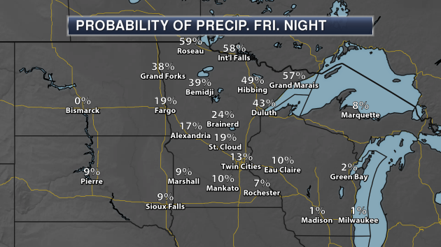
We
will be tracking the potential of rain into Friday night as well, but
the best chance of seeing any will be across northern Minnesota. Chance
only sit at about 10-20% across parts of southern Minnesota.
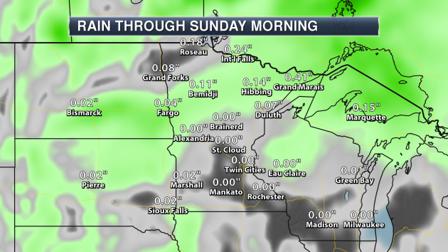
Overall
rainfall totals are expected to be light, with the heaviest (a few
tenths of an inch) expected across northern Minnesota.

After
we see our slight chance of rain Friday Night... chance of rain are
fairly slim through the first full week of September at the moment and
even into the second week as well.
_______________________________________________
Latest On Harvey
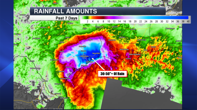
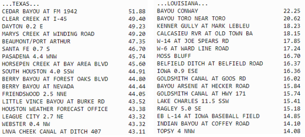
The
catastrophic floods from Harvey continue across portions of southeast
Texas and southwestern Louisiana even though the rains have long since
ended across the region. Areas from Houston to Beaumont have received
30-50" of rain over the past week. The Capital Weather Gang estimates that about 24.5 trillion gallons of water has fallen across the region due to Harvey.
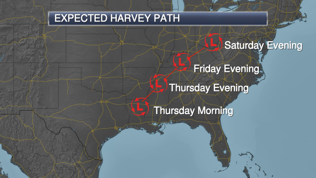
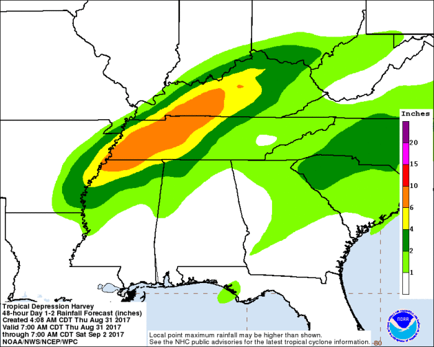
Rainfall
totals through Saturday morning from northern Mississippi to western
Kentucky are expected to be in the 3-6" range, with heavier totals of up
to 10" possible. This could lead to flash flooding across these
regions.
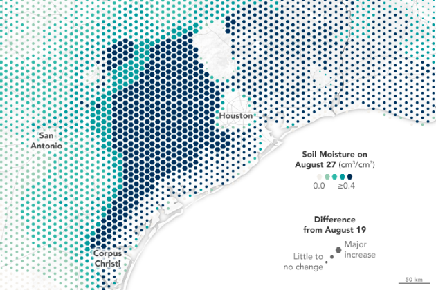
Of course, with heavy rain falling across parts of Texas and Louisiana, there was a major increase in soil moisture. More from the NASA Earth Observatory: "The
map above depicts soil conditions around south Texas on August 27
compared to values observed on August 19. Colors on the map represent
the amount of surface soil moisture, with the darkest colors
representing soil that is saturated or nearly so. The size of each
hexagon represents how much the level of soil moisture changed from the
days before Harvey to the middle of the event (the most recent date for
which we have data). Note that data are sparse in Houston itself, as
much of that area is covered by impervious surfaces (roads, buildings,
and infrastructure)."
A project called U-Flood is showing what local streets have been flooded due to Harvey. More from c|net: "The
project, by consultants at the environmental firm Marine Weather and
Climate and the tech company Tailwind Labs, is an interactive map of
flooding in Houston as well as other cities like Galveston, Baton Rouge
and New Orleans. It relies on the community to update the map, and so
far has received more than 1,500 reports. Currently, it's counting 991
roads inundated in Houston as a result of Hurricane Harvey." (Image: The pink lines indicate flooded streets. U-Flood)
Repairs From Apple & Dell Delayed Due To Harvey
Are
you waiting on a repair from Apple or Dell? You might be waiting a
while, as both companies have repair facilities in Houston. More from Gizmodo: "As
Texas recovers from the battering winds and record-setting rainfall of
Hurricane Harvey, Apple and Dell customers elsewhere in the US are
learning the storm may have some unforeseen consequences. “I got a call
from an Apple employee at the Genius Bar saying that all of their laptop
repairs go through Houston. I was told that it would probably take
several weeks or even months to get the laptop back,” a tipster wrote to
Gizmodo last night. The tipster added, “I also had a similar
conversation with Dell about delays in getting a monitor repaired.”"
_______________________________________________
National Weather Outlook
Friday Highs
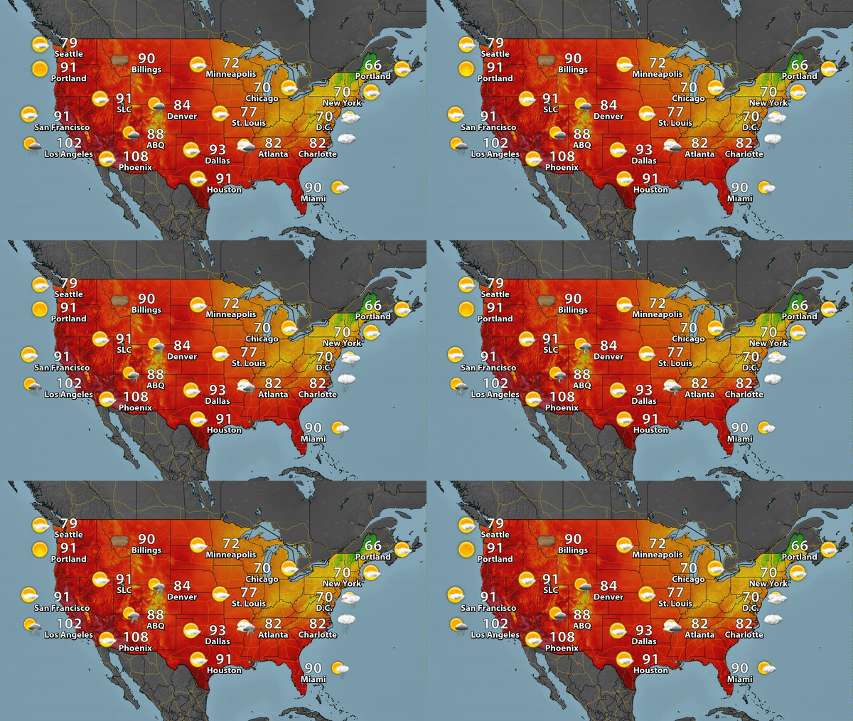
While
Harvey continues to push through the Tennessee and Ohio Valleys,
temperatures will be warming across parts of the west on Friday, with
numerous record highs expected in California (more on that in a moment).
It'll feel more like the end of September versus the beginning of it,
though, from the upper Midwest to the Northeast. Highs will not make it
out of the 50s across parts of New England Friday.
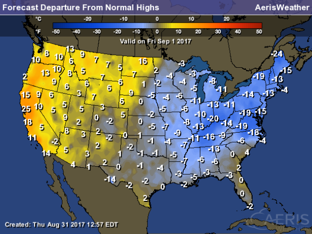
Highs
will be cooler than average across portions of the eastern United
States, with the greatest departures found in the Northeast and Ohio
Valley which will be on the order of 10-20 degrees. It'll be warm out
west, however, with highs that are a good 10-20 degrees above average.
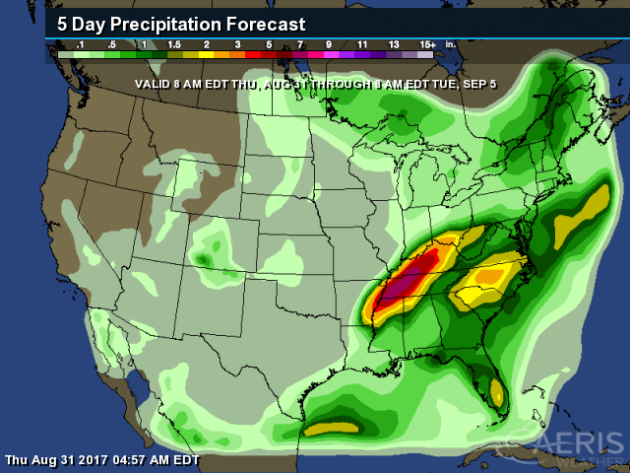
The
heaviest rain through the Labor Day weekend will be across parts of the
Tennessee and Ohio Valleys, as well as in the Mid-Atlantic, thanks to
Harvey.
_______________________________________________
NCAR To Cut Jobs Due To Flat Budget
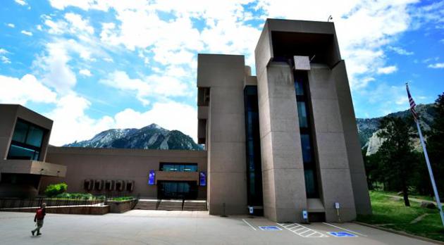
Hopefully
this doesn't prevent them from continuing to provide the excellent data
that they do, though I unfortunately have my doubts. More from the Boulder Daily Camera: "Management
at Boulder's National Center for Atmospheric Research on Wednesday
announced program reductions with corresponding reductions in staff,
which will result in the elimination of 18 positions that receive base
funding from the National Science Foundation. Also announced was the
elimination of 18 currently vacant positions, which translate to eight
full-time equivalents. In combination with other non-labor reductions,
the changes announced Wednesday, effective immediately, represent about
$9 million of NCAR's base funding from NSF." (Image: Boulder's National
Center for Atmospheric Research on Wednesday announced 18 staff
reductions in response to several years of flat budgets." (Paul Aiken))
FedEx and Disasters
How does FedEx manage disasters - and still get you your package? Popular Science has an except from a book call QUAKELAND: On the Road to America’s Next Devastating Earthquake by Kathryn Miles: "Dave
Lusk is senior manager of global operations for FedEx. At least, that’s
what his business card says. On the grounds of a FedEx facility, he’s
known as the “master of disaster.” He’s the guy at the center of
contingency planning and triage whenever something goes wrong anywhere
FedEx services, which is to say pretty much anywhere in the world. About
fifteen minutes before our appointed meeting time, Lusk sends an email
apologizing and saying that he will be a half hour late—a big storm is
brewing in the Northeast. I didn’t think to check my email. And so, a
few minutes after that message, he also sent a text. The master of
disaster is also the master of multitasking."
_______________________________________________
Thanks for checking in and have a great Friday! Don't forget to follow me on Twitter (@dkayserwx) and like me on Facebook (Meteorologist D.J. Kayser)!
- D.J. Kayser

- D.J. Kayser
No comments:
Post a Comment