Minnesota meteorologist are speechless, at a rare and welcome loss for words. Lately they've been driven to desperate measures to fill time, reviewing state capitals, favorite recipes, cleaning their weather offices - talking about the Twins Opener (39 days and counting) - dazed spectators, watching snow pile up in Waco, Texas, Atlanta, Georgia and New York City. Cue the crickets. Yes, it's been quiet across Minnesota, Honolulu-quiet, going on 3 dry, sun-splashed weeks in a row. Snow lovers have pretty much given up on the Winter of '10, which may be a bit premature. If you've lived in Minnesota longer than (a week) you realize how quickly the pattern can change, only in Minnesota can you grill out on the back patio with slush in your boots.
 Don't sweat the potholes. I'm afraid - very afraid.
The quasi-permanent glacier outside my window is slowly shrinking before my eyes, a daily serenade of drippy icicles and gurgling drainspouts. It's hard to deny that there's just a hint - a touch - of spring in the air, Tuesday's 42-degree high at MSP the warmest since December 1, when the mercury hit 47 in the Twin Cities. Today's average high: 35 F, and it looks like daytime highs will consistently be 5, to as much as 10 degrees, above average. The 11" of snow on the ground will probably shrink to about 6-7" by this time next week, at the rate we're going, with the current pace of melting and the predicted highs.

Our slow-motion thaw, coupled with an unusual lack of snow (or rain) has been a best-case scenario for the spring flood season in Minnesota. I realize that snow-lovers are disappointed. I get that, but for the sake of everyone living along the Mississippi, Minnesota and Red Rivers - the almost surreal lack of "weather" - now going on three weeks - has come at a very good time. The bottom line: the more snow that melts, the more of the sun's energy can go into heating up the air vs. melting snow pack. Within 2-3 weeks we should see our first 50s (once snow cover drops below 2-3" or so). Within the next 2-3 weeks we'll experience our first significant rainfall, and odds favor at least 2-3 "substantial snowfalls" of at least 1-3" or more. The big difference: when it snow in January the snow lingers (indefinitely). When it snows a few inches in March most of the new snow tends to melt within 1-2 days. Keep in mind the sun is as high in the sky today as it was back on October 8; we're picking up nearly 2 minutes of additional daylight every day - by the end of the month the average high will be close to 50 degrees. I know, hard to believe, but there's no question (now) that the "worst of winter is behind us." No question.
 Minnesota Smog. We've had over 10 days in recent months with unhealthy air in the Twin Cities. High pressure stalled almost directly overhead has produced unusually light winds and a persistent inversion, trapping man-made particle pollutants near the ground. During a normal March, with cooling temperatures with altitude and strong mixing of the air overhead, these pollutants are normally spread scores, even hundreds of miles downwind from major urban centers. But when winds are unusually light (as they are now) those pollutants can build up to unhealthy levels near the ground. This impacts kids, athletes and people with heart & respiratory issues. In the words of the MPCA, "since fine particles can be drawn deeply into the lungs, it is a good idea to reduce or postpone activities that lead to deep or accelerating breathing. Exposure to high levels of fine particles may cause chest pain, shortness of breath, coughing or fatigue, even after air quality has improved. If you experience these symptoms, contact your physician. Even individuals who are otherwise healthy may experience health effects when air pollution increases.
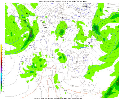
 Sloppy Saturday? Weather models bring light (mixed) precipitation into Minnesota Saturday, the rain-snow line forecast to run across central Minnesota, wet snow possible from Alexandria and Wadena to Brainerd, with a mixed bag in St. Cloud, and mostly rain for the Twin Cities, Rochester and Mankato.
Precipitation? Models are still hinting at weak "inverted trough", a cold, destabilizing wrinkle of air several miles overhead, passing over the state on Saturday. Temperatures throughout the lowest mile of the atmosphere may be just a degree or two above freezing across southern MN, including the Twin Cities, implying mostly rain. Closer to St. Cloud, Little Falls and Mille Lacs, closer to the rain-snow line, a sloppy mix of wintry precipitation is possible, with a greater potential for a little glaze ice early in the day (Saturday). Timing will be everything. If precipitation arrives before 8 or 9 am, there's a better chance of icing, especially outside St. Cloud, Willmar and Glencoe, with a couple inches of slushy snow over far southwestern Minnesota. Most roads will be wet by late morning - your odds of better travel conditions statewide improve the later in the day you leave the house Saturday.
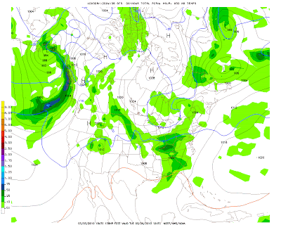
 Near-Miss? Valid Tuesday morning at 7 am, the brunt of the next storm's energy and moisture slides off just south of Minnesota, possibly brushing far southwestern counties with a little slush, drizzle and freezing drizzle. It's a close call, and even a slight northward jog in the storm track could bring rain (or wet snow) into the Twin Cities later Monday into Tuesday.
Next week? The very latest models keep the second (stronger) storm south of Minnesota next Monday and Tuesday, a mix of rain and some snow across Iowa, possibly brushing the far southernmost counties of Minnesota, but the truth: it's still too early to know if (and how) the second storm will impact the state. Too many unknowns.
A few stories that caught my attention:

A Shower of Fish? Say what? Last Thursday and Friday brought numerous reports of "fish showers" across Australia's Northern Territory. Apparently heavy downpours and severe thunderstorms were intense enough to form brief waterspouts, which lifted fish into these intense updrafts. After the severe storms dissipated and the updrafts weakened all these (countless thousands) of fish dropped back to the ground, causing a lot of shocked onlookers below! The complete (eye-opening) story from Down Under is here.
"Scientists study local factors that might contribute to forming tornadoes." An interesting story here.

"Scientists taking steps to defend work on climate change." A good summary of the state of climate science (and a possible need for a reset) in the New York Times is here.
"Questions and answers on climate change" from the Chicago Tribune. A good overview here.
Minnesota February Climate Review (from the MN State Climatology Office). The latest write-up from local climatologist Greg Spoden is here.
Paul's Conservation MN Outlook for the Twin Cities and all of Minnesota
Today: Our weather honeymoon continues. Plenty of sun. Winds: East 3-8. High: 41
Thursday night: Partly cloudy. Low: 24
Friday: Fading sun, high clouds increase, still milder than average. High: 41
Saturday: Ice possible early, especially outside the metro area. Chance of light rain/drizzle (mixed with snow far southwest, west and central counties). Low: 25. High: 38
Sunday: Mostly cloudy, a better travel day. Low: 26. High: 41
Monday: Cloudy, chance of a little drizzle. Low: 28. High: 43
Tuesday: Mostly cloudy, chance of rain/snow far southern MN. Low: 28. High: 40
Wednesday: Partly sunny. Low: 25. High: 42
No comments:
Post a Comment