My first job interview the News Director took me to see the Mary Tyler Moore house on Lake of the Isles in Minneapolis, lunch at the Orion Room at the top of the IDS Tower, and then they took me to the Byerly's in St. Louis Park. That sealed the deal, I swear on everything holy. I thought to myself, "any community that has a GROCERY STORE like this has to be doing something right." I signed a deal, knowing that Gannett was about to buy the station, they had big plans, including hiring this guy from San Diego, Paul Magers, Ron's younger brother. "He will be a sensation in this market," the news director whispered. He was right. WTCN-TV kept me off the air for 2 months, until I could pronounce all those Native American names like "Wayzata" and "Isanti" and "Lac Qui Parle." Management was terrified of my age, I looked REALLY young. I was 23, but looked 17. I remember the good old days, when Star Tribune New/Media columnist Nick Coleman gleefully referred to me as "weather-boy." That stung (at the time) but I promised him I'd age, and not necessarily gracefully. BTW, nobody has called me weather boy for a long, long time. I've been called other things...don't want to go into that right now. Use your imagination.
 "PD", pre-transplants. This was from my "SNC" days in Stamford, Connecticut, modeled after the all-news format that made Group W's all-news radio stations in major markets so successful. "Give us 22 minutes, we'll give you the world," was the motto. Yes, we crammed news, sports and weather into 22 minute cycles that kept repeating, 24/7. Group W and ABC teamed up to launch SNC, it was on the air from 1982-1984, but then Ted Turner (CNN) bought them out, and pulled the plug. We were competition for CNN Headline News, and he didn't want any competition for ad dollars. Too bad SNC's owners didn't stick it out a little longer; I suspect it would have turned into a very successful venture, given enough time. But they were bleeding red ink, happy to throw in the towel.
I've made no secret of being follicly-challenged. I started losing my hair my senior year in college, at the ripe old age of 21. It eats away at you, I don't care what line of work you're in, but especially on the tube. You don't see too many bald or balding people delivering news, sports or weather on TV. Vanity? Perhaps, but nobody wants to look older than they really are. Losing your hair, little by little, every day - is the rough equivalent of waking up every morning and realizing that your ears and nose have grown (a little) overnight. It really starts to wear on you. "Rogaine" and "Minoxidil" is a temporary Band Aid (it helps a little), the only true "cure" is a hair transplant. The procedure has become much better over the years, now they transplant hairs, one-at-a-time, like transplanting shrubs. They take hair from the back and sides of your scalp and transplant it on top of your head. It's an amazing procedure, the "plugs" go dormant for about a month, but then, within 30-45 days "new hair" starts to grow in areas you haven't seen it grow in a long time. The process is only mildly painful (you're home the same day), the costs have come down (a little) but it's still fairly expensive. Why am I telling you this? Transparency - I don't want others to agonize about this like I did in my 20s. You don't have to suffer if you're losing your hair, whether you're a man or a woman. There are options. I used Dr. Ron Shapiro at the Shapiro Medical Group down in Bloomington - you want to go to the guy who publishes papers and pushes the envelope with hair transplantation research. He's that guy. And no, I didn't get a kick-back or commission to mention his name. It was 15-20 years ago. My intent is to help other men and women take that next step. If it's really bugging you - do something about it. The first consultation is free, btw.
 Smoking Gun. Yep, this is the photo that probably got me fired. Amazing what dreck and ick you can find on the Internet, this must have been early 90s? No idea what this photo-shoot was for (I think it was the cover of Mpls. St. Paul Magazine, but I'm having a senior moment).
Getting back to my story about my WTCN/KARE days, management sat me down in 1983, shortly after I arrived, wanted to know all about my previous outdoor weather presentations at WNEP-TV, in the Wilkes Barre/Scranton market of northeastern PA. The station had a slit in a garage door, they aimed a camera through the slit and had the weather "talent" stand in front of an outdoor shed, back in the days of magnetic weather symbols. I'm dating myself big-time. Don't do the math. It was 1979, I was a senior at Penn State. I paid my way through college with a little consulting company, "Total Weather", did weather reports for 11 radio stations from my dorm room, loved it. I had no inkling or desire for TV weather, very content to focus on radio, "had a face for radio", as my friends liked to remind me. Some friends.
So the new News Director at KARE-11, Tom Kirby, asked me to attempt a "backyard" in Minnesota. "Paul, we'll blow out one side of the building and put in a garden! You can start indoors, then walk outside, show Minnesotans how to dress!" I was fairly convinced Minnesotans knew how to dress, btw. I thought about it. "How cold does it get in the winter up here," I asked? "No worries, you won't be outside long enough to suffer from frostbite," he assured me. Right. Belinda Jensen was an intern, who went on to be a star in Salt Lake City, I was happy to be able to help to hire her at KARE-11, and now (of course) she has gone on to very big things, become a true star. I'm very proud of her. And yes, she is as nice off the air as she is on the air. She's the real deal.
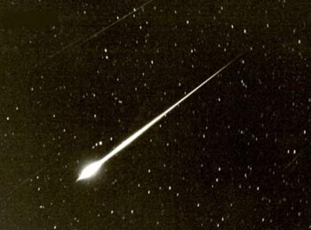
Fireball. What the heck happened last night around 10 pm? A giant fireball visible for a few seconds? Must have been a meteor, perhaps a piece of cosmic rock the size of a pebble or small stone, streaking through the sky, burning up on re-entry into the atmosphere? The Gamma Geminid meteor shower is underway - all I can think is that this was an especially large/significant meteor associated with the current meteor shower - makes sense. Extra credit points for anyone who sends in a photo - I wish I had something to give away. I have to work on that. But PLEASE, if you know someone who was able to (somehow) snap a picture of this thing - send it to Conservation Minnesota's web site!
 Wednesday Rainfall Estimates. Here are estimated rainfall amounts from the NWS Chanhassen Doppler radar. The key is on the far left (click on the image to bring it full screen). Bottom line: not much fell, under .10" for most of us, but some .50"+ amounts were estimated over western Wisconsin, between Balsam Lake and Bloomer.
 Dew Point Trends. After peaking near 60 overnight, a west to northwest wind will pump considerably drier air into town over the next 24 ours. Every 20 degree drop in dew point means half as much water vapor in the air. In other words, a day with a dew point of 40 means HALF as much moisture in the air as a day when the dew point is 60. Unlike relative humidity, which, as the name implies, is relative, dew point is an ABSOLUTE measure of how much water is in the air. You can have a day when the RH is 80%, but if the temperature is 65 it won't feel bad at all. However, on a 95 degree day a relative humidity of only 30-40% can be incredibly oppressive. The whole RH-thing can be a bit misleading. I know a lot of people still prefer relative humidity, but dew point is a simpler way to get ONE NUMBER that never changes, doesn't depend on the air temperature. 40-55 is comfortable, a dew point of 60 is "sticky", 70 is "tropical/ugly!" and a dew point exceeding 80 can truly be life-threatening, usually only happens once or twice a summer.
 Hail Season. Here are the specifics for Monday's hail event across southern Minnesota. A slow-moving warm frontal boundary sparked heavy thunderstorms, some 3"+ rainfall amounts near Delano, Willmar and Hutchinson, and a few reports of ping pong size hail across far southern Minnesota. Remember, to be considered "severe", a thunderstorm has to produce 58 mph+ winds and/or hail 1"in diameter (quarter-size) or larger. Last year the criteria was 3/4" hail, but the NWS was issuing too many warnings, the public was becoming apathetic about severe storm warnings. And recent research shows that - usually - hail has to be 1" or larger to cause real damage to rooftops or car surfaces, especially if it's whipped up by strong straight-line winds of 60 mph. or higher. Click here to read more about Monday's hail event from the local NWS office.
Can you tell there's precious little weather to babble about? Yesterday's cool front dropped a whopping .07" of rain on the Twin Cities, barely enough to settle the dust. After some leftover clouds this morning, a few straggling showers over southeastern MN, sunshine should be on the increase, a drying westerly wind coaxing the mercury close to 70 by late afternoon. No problems for evening baseball practice or a spin on the bike. In fact that will be the verdict through Tuesday of next week - an extended vacation from anything remotely considered "weather."
A bubble of high pressure arrives over the weekend, promising a deep-blue sky, light winds, a slight chance of spotty frost, mainly north of St. Cloud, both Saturday and Sunday morning (if winds die down and skies are crystal clear, a distinct possibility). Yes, a few of those blooming daffodils and tulips may freeze their buds off. Snow? Nope. Cold fronts? Don't see anything chilly looking out 15 days or so on the GFS model. We cool off slightly over the weekend (if you call low 60s a "cool front") but winds swing around to the south early next week, that should mean a shot at 70 by Tuesday of next week. It's still pretty far off, but roughly a week from now we could be sampling a significant shot of rain, the models hinting at .50 to 1" of rain next Wednesday and Thursday. I'll believe it when I see it - all the models have been consistently over-predicting rain for well over a month now. Not sure why, just noticing a consistency in these "busted" rainfall forecasts. When in doubt, blame it on El Nino. Or my accountant. How on earth did it already get to be April 15? I'm just now paying off my Christmas credit card bills.
 Big Storm Roughly One Week Out? A lot can and will change between now and next Thursday, but once again the GFS is attempting to print out a significant storm for the Upper Midwest, a moist "fetch" of air direct from the Gulf of Mexico, fueling an intensifying storm on the High Plains. The model is hinting at over 1" of rain, but I'm skeptical. The models have consistently been overpredicting rain ever since early March. Maybe El Nino is gumming up the models, how they're "initialized" or started. Not sure who or what is to blame, but we never seem to get all the rain the models print out. By the time the fronts/storms limp into Minnesota they're "used", all rained-out, we're left with a few dribs and drabs of rain, a third to 1/10th what was predicted. Not kicking the models when they're down, but something is wrong with the simulations we use to TRY and predict Minnesota's weather. Hope we get the rain though, we need it. The timing for farmers would be perfect.
Next week is Severe Weather Awareness Week in Minnesota - we'll work with the NWS to recap severe weather information all next week, a test of the emergency outdoor sirens scheduled for next Thursday, hopefully NOT on a day when there's any real severe weather lurking nearby. We've been pretty lucky on the severe weather scorecard so far this spring, it's been a bit too dry in the lowest levels of the atmosphere. Our first tornado watch is probably less than 2 weeks away - enjoy the extended spell of AMAZING weather, well-timed for another memorable, post-card-perfect, Chamber of Commerce-endorsed weekend. Keep it a secret eh?
 Metro Skywarn. Interested in weather? Like storms? Interested in helping the National Weather Service and local Civil Defense authorities in detecting severe storms and disseminating this potentially life-saving information to the public? This is different than "storm-chasing", where people try to intercept severe weather (mostly tornadoes) to get the "money-shot" of the funnel descending to the ground. With Skywarn you receive training, learn how to operate a mobile HAM radio unit, and you're dispatched to predesignated areas when a watch is issued. You literally watch for threatening signs, wall clouds, hail, anything that can help NWS meteorologists confirm that rotation on Doppler radar is actually reaching the ground. This "ground truth" is invaluable - it can literally save lives. If you have the interest, a little time, and are willing to be trained, check out the upcoming training sessions coming up for Metro Skywarn. Trust me, you won't be disappointed.
Paul's Conservation MN Outlook for the Twin Cities and all of Minnesota
Today: Damp, gray start (showers far southeastern MN). Then partly sunny, windy and drier by afternoon. Winds: W 15-25. High: near 70
Thursday night: Partly cloudy, cooling off a bit. Low: 44
Friday: Sunny with a stiff wind, less humid. High: 62
Saturday: Bright sun, less wind. High: 65 (Saturday wake-up temp: 39, frost possible north of St. Cloud).
Sunday: Plenty of sun, few complaints about the weather. High: 66 (after waking up to 44)
Monday: Partly cloudy, still dry. High: 63
Tuesday: Becoming mostly cloudy, breezy and more humid. High: 68
Wednesday: Rain, possible thunderstorms (potential for heavy rain). High: 61
That storm was 27 years ago, not 17. Ah, this year 2010 has everything fouled up.
ReplyDelete