
Severe Threat Details:
Growing Severe Risk. SPC has extended the severe threat through Friday morning into parts of central MN, including Willmar and St. Cloud. The main risk is torrential rains and frequent lightning, but hail and an isolated tornado can't be ruled out, especially south/west of the MN River. See the latest from SPC here.
Friday Severe Risk. With dew points in the 60s, significant wind shear (changing wind speeds/directions with altitude) and sufficient instability aloft - coupled with a warm frontal boundary snaking across southern MN - expect a few isolated severe storms over the southern third of MN Friday, including St. Cloud, the Twin Cities and Rochester. There will be watches and warnings until the front passes through early Saturday morning. Stay alert and stay tuned for updates.
Get ready for a serious case of the "stickies." The last few days have been unusually cool and comfortable - it's felt more like late September out there with dew point temperatures in the upper 40s and low 50s - all thanks to a breeze of Canadian origin. A noisy, thundery frontal boundary near Kansas City is about to do a U-turn and come surging north, setting the stage for a few rounds of heavy thunderstorms - best chance Thursday night, again Friday night. We may have a favorable environment for clusters of heavy thunderstorms sprouting late each night, a phenomena known as an MCS, a meso-convective system, which is a mouthful. These late-night storms rarely produce severe weather, but they can whip up copious, flooding rains, with some 2-4" rainfall amounts not impossible the next couple of nights (the latest model prints out a 2.6" rainfall bulls-eye near St. Cloud by Friday morning at 6 am). We'll see. This is the kind of scenario where one farm will get soaked with a few inches of rain, 20 miles down the road the sun is out and neighbors are wondering what all the fuss is about. Meanwhile, meteorologists are pulling out what little (gray) hair is left on the top of their pointy-little heads.
 Wednesday Almanac. After a sunny start instability clouds (triggered by unusually chilly air aloft) blossomed over central and northern MN, keeping temperatures nearly 10 degrees cooler than they would have been had the sun stayed out. Highs ranged from a brisk 68 at Alexandria to 71 in St. Cloud and 74 in the suburbs of the Twin Cities.
The weather slowly sours today, any sun fading behind increasing clouds, highs stuck in the 70s, with a bit more humidity in the air. A few (strong) T-storms may enter far western MN by evening, the BEST chance of T-storms coming, statewide, tonight as one of those MCS systems tries to rev up. Any storms would probably weaken Friday morning, pushing into Wisconsin, enough murky, hazy sun spilling through Friday midday and afternoon for highs in the low 80s south, with a dew point rising through the 60s. Yes, neighbors WILL be whining about humidity levels - give it about 24 hours.
 MCS Potential? The NAM computer model prints out some 1-3" rainfall amounts for the 6 hour period from midnight Thursday night through 6 am Friday morning, hinting at the possible formation of a meso-convective system, a sprawling line of heavy thunderstorms capable of torrential rains and frequent lightning. Any storms Thursday night and first thing Friday would quickly dissipate during the day Friday as they rumble into Wisconsin.
 Friday Soaker? The weather models disagree about amounts, but they almost all agree that significant rain/storms arrive late Thursday night and early Friday morning, as the leading edge of warm, sticky air surges north into Minnesota. Warm fronts tend to become more vigorous (and wet) during the nighttime hours, as low-level jet stream winds focus warmth and moisture on frontal boundaries, resulting in extreme upward motion and thunderstorms.
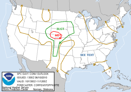
 Severe Risk. SPC prints out a few isolated severe storms over far southwestern MN through 6 am Friday morning. The greatest risk of damaging hail and violent winds may remain south/west of the Minnesota River, but soaking rains (and heavy thunderstorms) are possible across the rest of the state.
Another round of strong storms can't be ruled out late Friday and Friday night, we may have just enough instability, wind shear and low-level moisture for a few isolated severe storms to pop, especially over far southwestern Minnesota, where the risk appears to be greatest. Saturday's outlook is still an enigma wrapped in a riddle. Models are contradictory (nothing new) but the latest data suggests that the sticky, thundery frontal boundary may get nudged south and east of Rochester by midday Saturday, most of the storms firing up across Iowa, extreme southeastern MN and Wisconsin on Saturday, a wind shift to the west/northwest pumping in cooler, drier, more comfortable air Saturday PM hours, especially over central and northern Minnesota. We're keeping a fleeting T-storm in the forecast for Saturday, best chance south/east of MSP, but right now it does NOT look like a rerun of last Saturday's almost all-day wash-out. Yes, that "bust" has been branded into my overactive brain. That one scarred me just a bit. The odds of two Saturdays like that, back to back, are slim to 'nil. I pray.

Weekend Overview
Saturday: Partly sunny, breezy and cooler (big drop in humidity). Winds: NW 10-20. Hour of rain: 0. Highs: low/mid 70s south, 60s north.
Sunday: Partly sunny, breezy, less humidity. Patchy PM clouds up north). Highs: mid 60s (north) to mid 70s (south). Winds: NW 10-20. Hours of rain: 0. Morning temperatures: mid 50s far south to mid 40s up north (take a jacket!)
Sunday still appears to be the drier, more pleasant day statewide, with a cool, refreshing northwest breeze (10-20 mph), a big drop in humidity, and dry weather the rule from the Arrowhead and BWCA south to the Iowa line. Pack a sweatshirt or light jacket if you're heading north, temperatures may not climb out of the 60s up north, reaching low 70s south/east of St. Cloud. A bit chilly for the lake, but enough sun for a respectable tan (or burn). Sunshine lingers most of Monday and Tuesday, into the first half of Wednesday, before the next eastbound front arrives with another wall of water, another line of showers/T-storms Wednesday PM hours. I still don't see any stifling heat, or extended periods of beastly/sauna-like humidity, looking out the next 7-10 days. With the exception of a small severe storm risk Friday the sky over Minnesota should be very well-behaved through the end of next week -still waiting for the first official tornado touch-down, it's very unusual to be going this long into the spring season to see our first confirmed twister. No complaints - happy not to be hand-cuffed to the Doppler. We'll probably make up for lost ground in July and August. Yes, the atmosphere has an uncanny ability to "even things out" over the long haul.
 Aftermath. The day after the Streator, Illinois tornado. Imagine a landfill descending on your neighborhood - that's what a tornado is like, debris everywhere, pieces of homes, businesses, tree limbs, bricks, cans - anything and everything imaginable. The YouTube video is here.
 Convertible Kitchen. A tornado survivor surveying the remains of her home, after an EF-4 tornado swept through Millbury, Ohio, with winds estimated at 175-200 mph last weekend.
 The Day TV Weather Grew Up. Click here to read a great recap of one of the most amazing (and terrifying) days I can ever recall: April 3-4, 1974, the "Super Outbreak" of tornadoes: 148 separate tornadoes touching down on 13 states in a 24 hour period, a combined path length of 2,600 miles. There was no such thing as Doppler radar in 1974, just a few reconditioned radar systems, some dating back to the Korean and Vietnam wars, provisioned for use by local NWS offices. Radar helped to revolutionize the tracking of these tornadic T-storms, or the death toll would have been several orders of magnitude higher. This was one of the seminal events that helped to turn weather hobbyists into meteorologists - myself included. I remember that day like it was yesterday...
 Grand Isle State Park. This was the scene yesterday in coastal Louisiana - the coastline polluted with an oily brownish-reddish slime. Photo courtesy of the EPA.
 No Large Underwater Plumes of Oil? That's the word, according to BP Chief Operating Officer Doug Suttles claims no large underwater plumes of oil - in large concentrations - have been observed in the Gulf of Mexico. But divers plunging into the murky, oily waters beg to differ. First-hand observations and video from a recent dive are here.
 Feds Aware of a Second Spill. No idea if there's any truth to this, but here's the story from WDSU-TV in New Orleans.

Ship-Tracks. This high-res satellite image shows steam from ships in the Pacific.
 Thunderstorm Anvil From Space. From NASA, an amazing photo of a developing thunderstorm from an altitude of 200 miles above the Earth.
 Cloud-Doodles, Part I. Air flowing around islands can create amazing shapes in cloud cover just downwind, as evidenced by low-orbiting satellites. Source: NASA.
 Cloud-Doodles, Part II. Once again, a spectacular, naturally-occurring cloud formation downwind of an island. This is one of dozens of eye-opening, weird and wonderful photographs you can see at wired.com.
Climate Stories
 Concern About Climate Change Rising Again. A recent poll of 1,024 Americans showed that 61% of respondents believed climate change is real and deserving of our attention. The details from Discovery News are here.
 No Quick Fix on Warming, Says UN Climate Chief. The story is here.
 NASA Icebreaker Voyage to Probe Climate Change Impact on the Arctic. Click here to read the article.
* Is Global Warming Real? Click here for a reality check.
* The Politics of Global Warming. This timeline of stories takes advantage of Google's "Living Stories" initiative, an attempt to provide more perspective over time, allowing readers to see the progression/evolution of a story over time. Great idea - some solid, science-based articles here.
 Visual Time-Out. This has absolutely nothing to do with Minnesota's manic weather, but this HD time-lapse from Glacier National Park was a sight for sore, hyper-active eyes - definitely worth checking out here.
 June Almanac. Average/record information for every day of the month, courtesy of the MN State Climatology Office, is here.
Paul's Conservation MN Outlook for the Twin Cities and all of Minnesota
Today: Increasing clouds, more humidity, best chance of T-storms comes late afternoon/evening (especially far western MN). Winds: SE 10-20. High: 75
Thursday night: T-storms likely, some packing heavy rain and frequent lightning. Low: 64
Friday: Thundery start, then partly sunny, sticky and warm. Strong/severe storms possible again by evening. High: near 80 (low/mid 80s far southern MN, 70s central/north).
Saturday: Still unsettled with more clouds than sun, a passing shower or T-storm (but not an all-day washout like last Saturday was). Winds: SW/NW 10-20. High: 74
Sunday: Nicer day, but unusually cool. Partly sunny, breezy, more comfortable humidity levels. Winds: NW 10-20. High: 73
Monday: Plenty of sunshine, very pleasant. High: 76
Tuesday: Mostly sunny, very nice. High: near 80
Wednesday: Partly sunny - chance of T-storms late. High: 81
No comments:
Post a Comment