Update: 10:15 am. Moderate risk of severe storms across far southern MN - greatest risk of hail, violent straight-line winds and even an isolated tornado later today south of Granite Falls, Willmar and the Twin Cities - risk increases the closer you get to the Iowa border. I do expect watches and warnings by late afternoon/evening, a severe risk this evening morphing into more of a flood risk late tonight, especially southern third of MN. Keep checking in for more updates - I don't think it will be anything like last Thursday, but I could envision 2-4 tornadoes later today, especially south of the MN River.
I still can't believe it - I'm stunned, still overwhelmed by the tornadoes that swept across Minnesota last Thursday. The NWS is reporting 17 separate tornadoes in a 6-8 hour period, from the Red River Valley to the Iowa border.
Three of them were rare, violent, long-lasting EF-4 tornadoes, just about as powerful as they ever get, with winds over 175 mph. The most severe tornadoes were in the Wadena area - I've included a few (amazing) YouTube clips from Wadena, including footage of the actual tornado itself (shot from inside a home, which is definitely where you want to be when an EF-4 tornado passes through town). It was one of Minnesota's greatest tornado outbreaks, rivaling the '65 Fridley outbreak, which also produced F4 tornadoes from the Lake Minnetonka area to Fridley. That was long before Doppler radar and a dedicated team of 300+ SKYWARN weather spotters, in a day and age when sirens weren't as widespread, no live TV coverage, no Internet warnings - just 'CCO radio, which undoubtedly saved hundreds of lives.
 Wadena Tornado. The guys that shot this (amazing) footage are lucky to be alive. To their credit they stayed indoors, shot video through windows (not a great idea - the windows could have easily shattered). They were whooping and hollering like 4th graders - they had no idea that some of their neighbors were losing their lives as the EF-4 tornado passed overhead. Check it out for yourself here.
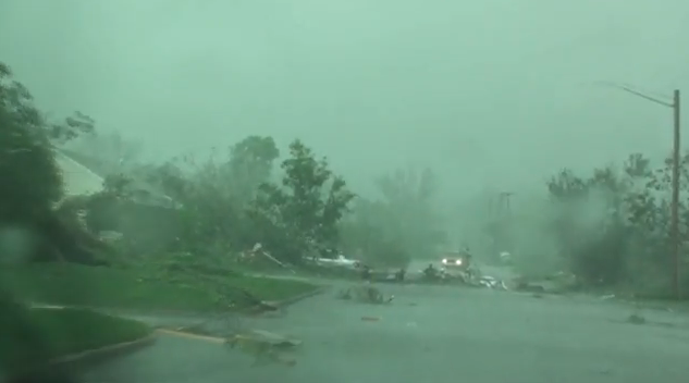 Incomprehensible Damage. This YouTube clip shows the early stages of the Wadena tornado (which at one point was, reportedly, nearly 1 mile wide). The aftermath is hard to comprehend - this video was shot immediately after the tornado ripped across neighborhoods, looking at the footage I am dumbfounded that there weren't even more injuries from this Kansas-size storm. Another clip that had me shaking my head is here. Much of Wadena resembles a war-zone.
International News. This video clip was filmed by Russia Today - showing the incredible power of the EF-4 tornado that swept through Wadena.
 Good Timing. It's a good thing the school year was over at Deer Creek High School in Wadena - damage to the structure was extensive, school buses tossed around hundreds of yards as the "multi-vortex" tornado (composed of as many as 5-7 smaller tornadoes all rotating around a common center) passed nearby.
Nothing like easing into tornado season. We went from 0 tornadoes from January 1 to June 16, to 17 the next day, over 2 month's worth of tornadoes in less than 8 hours. Incredible. Watches and warnings were posted, even residents of Wadena received ample warning a tornado was on the way - the death toll COULD have been in the hundreds. It's a minor miracle only 3 Minnesotans lost their lives, considering the intensity of these twisters. I am not in any way minimizing the tragic loss of life, every story of loss was heartbreaking - I'm just pointing out the obvious: we could have experienced a major loss of life last Thursday, but all in all the system worked the way it was supposed to work. Doppler radar (which works best on the big tornadoes) detected intense rotation - warnings were issued even before SKYWARN spotters and law enforcement on the ground confirmed tornadoes were touching down. Warning times ranged from 10 to 20 minutes in most cases, plenty of time to reach a basement or sturdy (interior) room.
 North Woods Twisters. Add 2 more to the list - we're up to 20 tornadoes for the season as of June 21. A couple of brief touchdowns were reported in Marshall county, in far northwestern Minnesota - no reports of injuries or extensive damage, but it was another (blunt) reminder that June is prime time for tornadoes. Again, we're seeing a northward shift in the tornado belt, large, long-lasting twisters in the North Woods of Minnesota and Wisconsin in recent years. To see yesterday's national storm report from SPC click here.
 Monday Almanac. After a turbulent day the sun came out across much of Minnesota by evening, luring the mercury to 80 in St. Cloud (.18" rain), 79 in the Twin Cities (.07" rain). Hibbing was soaked with over half an inch of rain.
 Montana Tornado. This is nothings short of amazing - a tornado ripping through downtown Billings, Montana. Since when is Billings in tornado alley? It's true that every state in the USA has experienced at least one tornado (including Alaska and Hawaii) but Montana is (historically) too dry for large tornadoes. Even so a significant tornado roared across downtown Billings on Sunday - producing significant damage. The video and details are here.
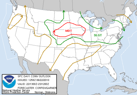
 Slight Severe Risk. Here we go again. Although the sun should be out most of the day today conditions aloft are ripe for a few (isolated) severe storms by late afternoon and evening. I don't expect an outbreak to rival last Thursday (hopefully we won't see anything that intense or widespread for another decade or two) but with enough low-level moisture and wind shear we can't rule out violent straight-line winds, even a stray tornado. I expect watches and warnings to be issued later today.
PM Thunder? Here is the NAM model, valid around the dinner hour today, hinting at a band of strong/severe storms, best chance across the southern third of Minnesota. Stay alert for possible severe storms later today, best chance after 3 or 4 pm.

Another MCS? The NAM model valid 6 am Wednesday morning is printing out some incredible 4-6" rainfall amounts across northern Iowa and southern MN. At first I thought this was just "noise" in the computers, but the more I studied the pattern the more I came to realize that with 70-degree dew point air lurking to our south over Iowa, conditions are, in fact, ripe for another swarm of late-night storms to mushroom late tonight - we may wake up to a thundery start Wednesday morning, especially south of St. Cloud and the Twin Cities.
June is living up to its reputation as the wettest month of the year, no doubt. We're two thirds of the way through June, and already nearly 3" of rain has fallen, many communities will pick up at least an inch or two of additional rain through Saturday. Farmers are (relatively) happy, soil moisture in very good shape - no widespread hail storms in recent weeks capable of flattening crops, wiping out an entire growing season in the meteorological blink of an eye. In that respect we've been very lucky, at least so far.
 Farmers are Smiling. Well, maybe not smiling, but they have good reason to be optimistic. After a very dry start to the growing season we've caught up in the rainfall department, in fact it's far too wet just to our south across Iowa and Nebraska, as you can see on the latest Crop Moisture Index from NOAA.
Thundery, unstable weather lingers into much of Wednesday, hit-or-miss showers and storms scattered across the state. We may salvage a mostly-dry Thursday before that same, fickle front surges north, sparking yet another outbreak of strong T-storms Thursday night into Saturday. No continuous, all-day rains, but when it does rain the sky could open up in a hurry. That front will linger close to home into Saturday, meaning at least a couple hours of (hard) rain and thunder. By Sunday the front may get a gentle nudge to the south, my gut (nausea?) is telling me that Sunday will be the sunnier, drier day of the weekend. If the sun is out for a few hours both days we should see highs in the mid to upper 80s (with dew points in the 60s). It will be muggy, sticky, extremely lake-worthy. Yes, it will (finally) feel like summer out there for an entire weekend. Tell your friends - wake your neighbors - we may actually experience a June weekend the way it was meant to be: mostly sunny, partly-thundery, plenty warm for the lake or pool. I'm up for that.

A New Way to Track Weather. Check out the (free) interactive map from Ham Weather, a division of WeatherNation. What makes this graphic unique (and hopefully useful) is the ability to display real-time webcams from all around the USA and Canada, superimposed over looping radar - with an option to turn on watches and warnings. Leave it up on your browser and it updates automatically. I'm biased, but I think it's pretty cool - a 9 on the weather-geek-factor. Come to think of it "weather enthusiast" sounds better.
 A Hint of Smog. Here is the latest air quality information from AirNow, courtesy of the EPA. A lack of significant circulation is resulting in moderate air pollution in the Twin Cities region, the air quality considerably worse from Huntsville to Charlotte to Washington D.C. The very latest data is here.
 Canadian Wash-Out. Another day, another epic flood. This time the soggy bulls-eye is far western Canada, where torrential rains washed out the Trans-Canada highway in Saskatchewan. The video (and additional details) can be found here.
Study Questions Credentials of Climate Change Skeptics. I defer to a heart surgeon if I have trouble with my ticker, I call a professional plumber when my toilet backs up (sorry). Yet so many (non-experts) feel compelled to argue with climate scientists, because it doesn't fit their world-view or ideology. Just because we all experience "weather" does not make us experts on "climate". A recent study showed that 97% of professional climate scientists believe man is at least partly responsible for the steady warming Earth has experienced in recent decades. The story in the Vancouver Sun is here.
Paul's Conservation MN Outlook for the Twin Cities and all of Minnesota
Today: Sticky sunshine, a few strong/severe storms possible by late afternoon. Winds: SE 10-15. High: 86
Tuesday night: More T-storms, a few may be severe during the evening hours. Heavy rains possible with some of these storms, especially late night over far southern MN. Low: 65
Wednesday: Still humid and unstable with a few more T-storms. High: near 80
Thursday: Sunshine, much of the day should be dry. High: 85
Friday: More clouds than sun, more T-storms in the area. High: 86
Saturday: Partly sunny - a couple hours of showers/storms, but MOST of the day should be muggy and dry. High: 87
Sunday: Drier and sunnier - we may salvage a mostly-dry day. High: 88
Monday: Mix of clouds and sun, still summer-like. High: 86
No comments:
Post a Comment