Getting Better. The heaviest T-storms are now weakening, pushing well north/east of the metro area, leaving us with partly sunny skies - still a slight risk of isolated severe storms later, mainly south/east of the Twin Cities. As winds swing around to the northwest after lunch the risk of heavy weather will begin to diminish.
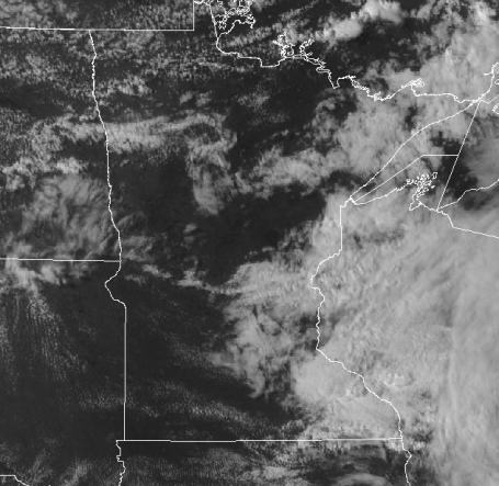
A Rainfall Dome over the Metro? Check out the rainfall amounts from this morning's squall line (the MCS) system that moved from southwest to northeast during the wee hours of the morning. Less than half an inch for most of the area, while some 2-3"+ amounts soaked far southeastern MN and parts of central MN, closer to St. Cloud, Mora and Willmar. Talk about a fickle pattern.
Camera Rolls As Tornado Strikes. Check out this amazing footage of a homeowner in Clarks Grove, Minnesota who left the camera rolling as a 1/2 mile-wide tornado approached. He did the right thing, camera rolling as he fled downstairs to the basement, eventually crawling under a pool table (!) The camera goes black, I'm assuming/hoping he was ok. Just when you think you've seen everything along comes something like this.

 (Update: Watch canceled). The watch expired at 4 am, but very heavy T-storms may linger through the morning hours, especially south/east of the Twin Cities. This latest swarm of strong/severe storms will give way to brightening skies by afternoon as winds swing around to the northwest. Morning event outdoors? Sorry - doesn't look promising. If you're trying to sneak outside after lunchtime you should be in better shape, a mostly-dry sky shaping up for the afternoon/evening hours.
* (Right now the models keep us mostly-dry from Tuesday through Friday of next week, the first 4-day stretch of rain-free weather so far this month).
Are your drip-dries drooping yet? A serious case of the soggies? I think I'm growing an umbrella (terribly painful). Yes, this month, when in doubt (which is fairly often, thank you) just predict T-storms. Odds are you'll be pretty close to the mark 93.4% of the time. Yes, June is the wettest, most severe month of the year in Minnesota, on average, the worst month to schedule, an outdoor wedding or say, a grad party. No kidding. After a remarkably warm, dry, storm-free March, April and May, Mother Nature appears to making up for lost time (and rain). Here in the Land of 10,000 Weather Extremes the dial is either set to "ON" or "OFF". Not much in-between.
June is prime-time for a rare breed of thunderstorm, the mysterious sounding mesoscale convective system, or MCS, as it's sometimes called (by pointy-headed weather geeks, myself included). These are no ordinary, garden-variety storms that mushroom late in the day in response to the sun's heating of the ground. A typical thunderstorm lasts maybe 45 minutes, eventually a rain and hail-cooled downdraft snuffs out the warm, rising updraft, and the storm fizzles.
Sometimes thunderstorms mushroom late at night, especially over the High Plains, especially in June, when steamy, tropical air surges north from the Gulf of Mexico. During the day rising thermals disrupt the low-level jet, but after dark that low-level jet becomes concentrated, focused, potentially potent, turning a firehose of moisture loose on frontal boundaries. Storms mushroom along these boundaries, growing exponentially, feeding on themselves, before turning into a "bow-echo", a horseshoe-shaped swirl of strong to severe thunderstorms surging east, covering 500-1000 miles in 12 hours, not weakening until the following morning. MCS systems rarely produce tornadoes, but they can produce intense straight-line winds, on rare occasions topping 80-100 mph, capable of tornado-like damage. They also unleash torrential rains, sometimes 2-5" amounts in a few hours, capable of flash flooding. Hail is another possibility.
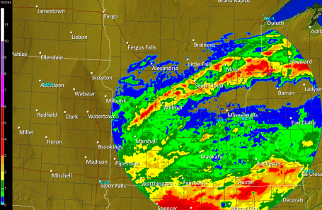
 Soggy Bulls-Eye. The NAM/WRF model shows the heaviest rains straddling the MN/IA border, but a few inches of rain isn't out of the question from Mankato and Rochester to the southern suburbs of the Twin Cities - the best chance of downpours coming early this morning.
 Serious Spritzing. The latest NAM model prints out some 2-3" rainfall amounts for far southern MN, about .75 to 1.5" for the Twin Cities, while St. Cloud escapes with a tenth of an inch. I think the models have the right idea - more rain the farther south you live, with a sharp cut-off in rain somewhere between Monticello and Little Falls.
Timing is tricky, these MCS systems usually form between 10 pm and 2 am, and then rumble through during the wee hours of the morning, leaving behind jumbo-size puddles for a white-knuckle commute a few hours later. This may be one of those mornings. True confession time: I'm pounding out this feeble blog at 10 pm Tuesday evening. The SPC has just issued a severe storm watch valid until 4 am Wednesday morning. All the ingredients are in place for a pretty lively outbreak of storms, with the greatest potential south of the MN River. Leave extra time to get around town this morning, there may be a LOT of standing water on area highways, even some wet basements and swollen streams. If you live in a flood-prone area you may have some issues through midday, when skies should finally brighten, the worst of the heavy-weather rumbling into Wisconsin.
Winds swing around to the north/northwest by afternoon, a drying breeze which may brighten skies a bit this afternoon and evening - if you have something planned for late afternoon or evening you'll probably be ok - the heaviest rains (and greatest severe risk) come early this morning. Models are hinting at some 2-4" rainfall amounts near the Iowa border, the farther south you live, the better the odds of waking up to a window-rattling, gutter-gushing storm.
The sun comes out Thursday - the only dry day in sight. A tangle of fronts will torment us with more scattered T-storms Friday (best chance far northern MN), and it sure looks like a few hours of showers and storms on Saturday - probably the wetter day of the weekend. It will be plenty warm with beastly-humidity-levels, dew points approaching 70. A slight wind shift to the north/northeast Sunday may shove the heaviest weather to our south Sunday, resulting in partial clearing and a noticeable (and welcome) drop in humidity, temperatures a few degrees cooler too.
Feel like you're growing an umbrella? Is moss growing on your northern side? Good news: the long-range GFS model is suggesting a 4-5 day (in a row!) stretch of dry skies, from Tuesday through Friday of next week. I don't even want to venture a guess for the 4th of July holiday weekend - but right now the GFS is pulling in a few storms by Saturday, July 3. A lot can and will change between now and then. God-willing we won't see a front stalling overhead producing significant, all-day rains, it's too early to even venture a semi-educated guess about how the big holiday weekend will play out.
Batten down the hatches, leave early - at this rate you won't be watering the lawn anytime soon. Yep, June is living up to its (soggy) rep.
 Stormy Saturday. I'm not panicking (yet), but the models are all pretty much agreeing on a cool frontal passage during the day Saturday, preceded by a few hours of showers, possibly some heavy/strong T-storms. A wind shift to the north/northeast should mean a drier, sunnier (nicer) Sunday.
 Montana Twister. More footage coming out of (downtown) Billings, Montana of the rare, historic tornado that struck over the weekend. Typical for Nebraska....but Montana? This may have been another 1-in-500-year event. Seems like we're seeing an awful lot of these 1-in-500-year storms lately. A coincidence? Possibly, but I doubt it.
 EF-Scale. The "enhanced" Fujita scale, named after famed University of Chicago tornado-researcher Theodore Fujita, was put into place 2 years ago - supposedly an improvement, a refinement in how tornado ferocity is measured. Keep in mind that 3 of last Thursday's 17 tornadoes were rare EF-4 tornadoes, winds estimated at 166 to 200 mph. No professional wind instrument has ever withstood the impact of a direct hit - they all blow away. All we can do is measure the effects of the winds, specifically, how far heavy objects are carried by the wind. More of the EF-scale from SPC (Storm Prediction Center) is here.
 Eagle, Wisconsin Tornado. The tornado that hit Eagle on June 21 may have produced winds as high as 100 mph. The "couplet clearly shows up on the velocity display (left), air moving toward the radar site shows up as bright green, air moving rapidly away from the Doppler site shows up as hot pink - definite evidence of strong rotation (and a clearly visible "hook" on the reflectivity display on the right). A recap from the NWS is here.
 Another Day - Another Epic Flood. The numbers coming out of northeastern Brazil are staggering, as many as 1,000 residents are still missing. The story is here.
 Light Show. Another display of nearly continuous lightning in this YouTube clip - Illinois has been particularly hard-hit in recent days.
 UV Index. Safe sun? No such thing. Dermatologists are increasingly warning of the perils of even moderate sunshine, especially for fair-skinned people. The risk of premature wrinkling, even melanoma, increases dramatically with repeated sun exposure. Right now the sun shining on Minnesota is as direct and intense as it ever gets. To calculate your exposure to potentially dangerous UV radiation click here. Everything in moderation, right?
* Vitamin D Health: Why You Shouldn't Shun the Sun. O.K. In the spirit of balance and equal time, here is a story about the benefits of (moderate) sunshine.
 BP, By The Numbers. These images are very hard to look at, but at some point disgust will turn to anger. Accidents happen, but there's growing evidence of negligence and safety-shortcuts. Some of these numbers are truly mind-boggling.
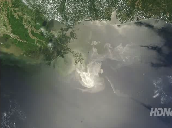 We Don't Know. Three of the scariest words in the English language, and they're being thrown around a lot when discussing the Deepwater Horizon spill in the Gulf of Mexico. The physical, tangible damage (to the ecosystem, business, our confidence that technology can cure all ills) is bad enough - but it's the fear of the unknown that is even worse. We are truly in uncharted waters with this disaster - I have to believe that smart (engineers) will figure this out, but right now...we just don't know. Dan Rather narrates a 2:42 video clip that ran on HDNet here.
 Antarctic Glacier Melt May Not Be The Result of Climate Change. Scientists using torpedoes to study the waters around Antarctic? Now I've heard everything - click here to read just how they're pulling that off.
* Study Affirms Consensus on Climate Change. The story in the New York Times is here.
Paul's Conservation MN Outlook for the Twin Cities and all of Minnesota
Today: Partly sunny, a slight risk of another shower or T-storm (A few could still be severe over far southeastern MN). Winds: NW 10-15 (by afternoon). High: near 80
Wednesday night: Partly cloudy, drying out. Low: 63
Thursday: Plenty of sun - umbrellas optional. High: 83
Friday: Partly sunny, more humid - best chance of T-storms far north. high: 84
Saturday: More clouds than sun, sticky and warm. A few hours of showers/T-storms likely, best chance PM hours. High: 86
Sunday: Drier, becoming partly sunny with a welcome dip in humidity. High: 82
Monday: Sunny start, PM clouds, passing shower. High: 81
Tuesday: Sunny and pleasant. High: near 80
No comments:
Post a Comment