

Storm Warning. Severe Thunderstorm warning posted for the Redwood Falls - Fairfax area for large hail and damaging wind gusts - potential for a fairly widespread severe storm outbreak
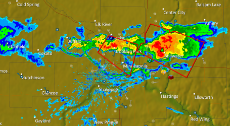
Moderate Risk. In some ways the maps look eerie similar to how they looked last Thursday, when 17 tornadoes formed in the skies over Minnesota. For the record I do NOT think today's outbreak will be quite that bad, but I would not be surprised to see 3-8 tornadoes later today, a few could be large, long-lasting, violent EF2-EF4 tornadoes. Stay alert and stay tuned for updates.
Probability of Tornadoes. This map shows the probability of a tornado within 25 miles of any point - a fairly significant (10%) risk of isolated tornadoes later today just west of the Twin Cities to the Dakota border.
As Far As The Eye Can See. Imagery like this really brings the oily catastrophe in the Gulf of Mexico home - this is a beach in the Florida panhandle, near Pensacola, drenched in oil from the Deepwater Horizon well still gushing uncontrollably less than 100 miles to the southwest. The YouTube video clip (complete with disgusted narration) is here.

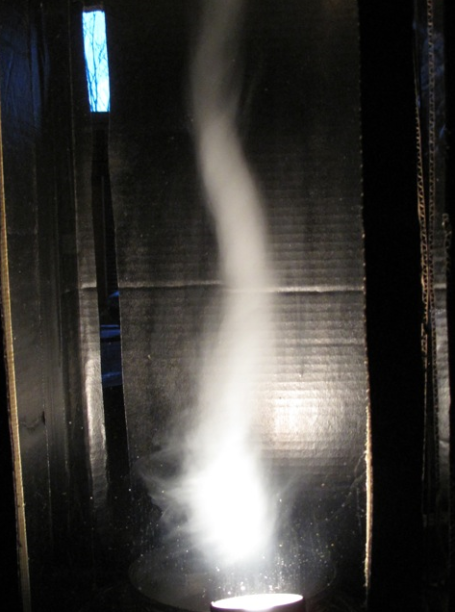
Nice to see the sun out (for more than a couple of fleeting hours). It was a gorgeous day across central and southern Minnesota, while north of Mille Lacs monster-thunderstorms bubbled up some 40,000 feet into the atmosphere, spawning hail, high winds, even a few funnel clouds from near Hibbing to the outskirts of Duluth. Here in the land of Atmospheric All-or-Nothing it's either bright sunshine and soothing breezes, or handball-size hail and winds strong enough to bring down small trees. That's summer in Minnesota, mostly-nice, partly-thundery, occasionally-violent.
 Thursday Almanac. The sun was out over the southern 2/3rds of Minnesota, resulting in a high of 82 at St. Cloud and the Twin Cities. Duluth saw severe storms, over a third of an inch of rain, the only major reporting station in Minnesota to report rain yesterday.
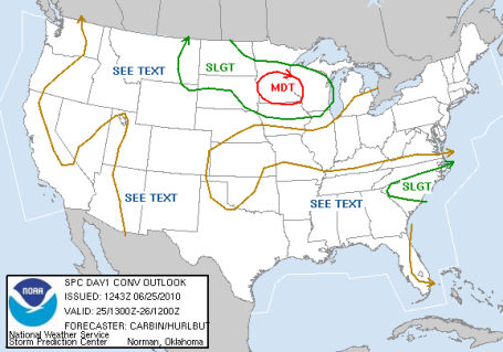
 Nagging Severe Risk. According to SPC there is slight risk of severe storms across most of Minnesota Friday, a 30% probability of winds > 58 mph and/or 1" diameter (quarter-size) hail within 25 miles of any town within the hash-marked area. Go about your normal activities, but keep an eye on the sky, stay tuned for possible watches and warnings later today.
A sunny, promising start gives way to an unsettled sky by midday Friday, an approaching front (more of a "dry front" than an actual cool front) will ignite more strong storms by afternoon - just about the entire state of Minnesota is under a slight risk of isolated severe storms, and I do expect watches and warnings by mid or late afternoon. SPC (Storm Prediction Center) is hinting at the best chance of hail, damaging straight-line winds, even an isolated tornado, over roughly the southern half of Minnesota, the best chance of rough weather boiling up around the dinner hour. Have a Plan B after about 3 or 4 pm tomorrow - evening activities are in doubt. If you're living right you may just luck out, but odds are not necessarily in your favor.
 Not a Total Loss. The NAM/WRF model valid 1 pm Saturday shows dry weather for the previos 6 hours across most of Minnesota, but showers/storms will spread from west to east Saturday PM, a few could turn severe by late afternoon and evening. That said, much of the daylight hours Saturday should be dry - more clouds than sun, but your best odds of salvaging a few dry hours will be during the morning and midday hours Saturday.
 Saturday Night Soaker? The NAM/WRF model is hinting at another INCH of rain Saturday night. Skies may dry out a bit during the day Sunday, before more T-storms flare up late Sunday afternoon/evening, best chance of rain north/east of the Twin Cities.
As usual, the weekend forecast is a riddle, wrapped in an enigma. The same front that spawned funnels east of Taconite late Thursday will push through later today, sparking a round of storms, then push to the south long enough for a partly sunny Saturday, then lift north again for yet another round of showers and storms Saturday night into Sunday morning, then push to the north/east during the day Sunday, resulting in partial clearing midday Sunday before storms redevelop north/east of the Twin Cities by late afternoon and evening Sunday. Got that? Yes, it's complicated. It's Minnesota Weather.
"Partly to Mostly with a Chance."
* Showers and storms are likely, off 'n on, throughout much of the weekend. If the sun comes out count your blessings.
Predicted Rainfall: (NAM model for MSP)
Friday PM/Night: .72"
Saturday night/Sunday: 1.05"
(Chance of isolated severe storms late Friday, again late Saturday and Saturday night pretty much statewide).
O.K. Before you toss your PC into the nearest pond, let me reassure you that some sense of normalcy will return to our weather pattern next week. A bloated bubble of Canadian high pressure will push into the Upper Midwest Monday, clearing skies, resulting in a weather winning streak of dry, mostly-sunny days most of next week. That's right: a very real possibility of (cue the drum-roll).....4-5 dry days IN A ROW!
Bottom line: a good chance of rain (spiked with thunder, lightning, possibly high winds and hail) late Friday, again late Saturday, Saturday night - showers taper off Sunday morning (some dry weather midday into the early afternoon Sunday, before yet another round of showers/storms blossom late Sunday). The best odds of dry weather: Saturday morning and Sunday midday/early afternoon. I can't promise bright, baby-blue skies, at best skies will be "partly sunny" (same thing as mostly cloudy) Saturday morning/midday and early Sunday afternoon - the best time to jam in some outdoor activities.
Why should anything be easy, especially a weekend in late June? I predict you'll have a blast, regardless of the condition of the skies overhead. With any luck it will NOT rain as hard as it did a few Saturdays ago. Hopefully no all-day washouts that will leave Minnesotans fuming....feeling irate, cheated.
We've had better weekends - but definitely worse too. Hopefully I'll have some better news for you later in the day Friday.
 "Couplet" The (amazing) GR2 Analyst weather program (sorry, even though I'm a Mac-lover, this program only runs on PC's, requires Direct-X - showed evidence of powerful rotation east of Taconite around 3:30 pm - the Duluth NWS issued tornado warnings, and sure enough, there were numerous reports of funnels with this "supercell" as it rumbled just south of the Hibbing area.
 A Lovely (Doppler) Sunset. That streak of blue stretching off to the northwest from Duluth's NWS NEXRAD Doppler Radar is the radar beam detecting the setting sun at 9:05 pm, right on schedule. By this time severe storms had pushed off just to the east of Duluth.
 The VERY Windy City. Chicago has been carpet-bombed by severe thunderstorms in recent weeks, mostly straight-line winds, exceeding 80 mph at times, accompanies by almost continuous lightning and torrential rains. The ground is saturated, waterlogged, any additional rain in the coming days will almost immediately run off into streets and streams. More on the barrage of storms here.
 Badly-Needed Rainbow. After the (severe) storms - a photogenic rainbow appeared east of Chicago, over Lake Michigan, a little hope in an otherwise wild and thundery June.
 60% Probability. According to NHC there is a 6 in 10 probability that an area of disturbed weather in the Caribbean will strengthen into the first tropical storm of the season, up from a 30% chance Wednesday. You can understand why residents living along the Gulf of Mexico are concerned about the track of this storm - the last thing those people need right now.
 Ominous Outlook. The latest NAM/WRF model shows significant organization in the Gulf of Mexico by Sunday evening - in spite of considerable wind shear an area of disturbed, thundery weather in the Caribbean south of Jamaica may strengthen into the first tropical storm of the season by the weekend. If sustained winds exceed 39 mph. we'll have Tropical Storm Alex. The impact on the oil spill? Unclear, but on its projected path Alex could push the underwater "clouds" of oil to the north and northwest, toward the Louisiana and Texas coastline. To check in on the latest updates from NHC, the National Hurricane Center, click here.
 Killing Time. What do you do if you're stuck at Atlanta Hartsfield Airport? Take your fancy and tape a little time-lapse of the sky outside your window as the plane pulls away from the gate. Click here to see some very cool footage. Nurture your inner-weather-geek.
 Early Fire Season. The "Medano" fire at the Great Sand Dunes National Park in Colorado has already scorched 5,000 acres - it continues to grow, fanned by strong winds, the blaze in a remote, hilly, hard-to-reach portion of the national park. A spectacular YouTube clip is here.
 Quake. Have you seen this yet? Here is some rather amazing video of the 5.0 earthquake that rocked Ottawa, Canada on Wednesday of this week. See what happens when you work out? Nothing good can come of curls in the afternoon.
 A Minnesota Connection. KSTP-TV had a great story about loons rescued from the oily mess off the Florida coast - being cleaned up and ultimately released in Minnesota. It's worth a look here.
Paul's Conservation MN Outlook for the Twin Cities and all of Minnesota
Today: Sunny start, clouds increase by afternoon. A few strong/severe T-storms likely by late afternoon/evening. Winds: S 10-20. High: 86
Friday night: Thunderstorms, some severe with very heavy rain and frequent lightning. Low: 67
Saturday: More clouds than sun - showers and storms arrive late in the day, a few could be severe once again. Winds: E 10-15. High: 82
Saturday night: Showers and storms likely - locally heavy rain likely. Low: 68
Sunday: Still unsettled, showers taper in the morning, another round of showers/storms late Sunday, best chance of rain north/east of the Twin Cities. Winds: W 10-20. High: 83
Monday: Partly sunny, drying out statewide. High: 82
Tuesday: Cooler and less humid with bright sun. High: 78
Wednesday: Sunny and pleasant. High: 79
Thursday: Plenty of sun, milder. High: 82
No comments:
Post a Comment