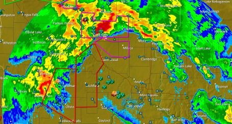
7:40 pm. Evolving MCS System? Storms are congealing into a massive swarm of straight-line winds and hail, forecast to sweep through the Twin Cities between roughly 8 and 10 pm. Wind damage is possible, and hail will range in size from marble to possibly golf ball size. Take precautions, batten down the hatches. The first "supercell" dropped tornadoes from near Sauk Centre to the southwest suburbs of the Twin Cities (reports of touchdowns around Watertown with significant damage reported). An isolated tornado can't be ruled out, but the main threat now is damaging straight-line winds and large hail. Stay alert - more updates forthcoming.
No comments:
Post a Comment