Doppler Update: 1:45 pm. A few isolated T-storms are popping up, mainly south of the Twin Cities, in response to abundant low-level moisture and a lingering wrinkle of cold air aloft - enough marginal instability for a few weak "cold air funnels" through the afternoon hours, mainly south of the MN River Valley. No watches or warnings are in effect - but be on the lookout for cloud to ground lightning, and if you see a developing funnel be ready to move inside (in a hurry!) These funnels rarely touch down, when they do damage is usually minimal, but stay alert through the afternoon hours - lightning the greater risk, all things considered.
Terror on the Lake. That's me, attempting to put on a brave face before getting pulled around the lake at 30 mph. My wife is cool, calm and collected, while I just want to be anywhere but precariously perched on a (leaking) tube. It ended badly. Note to self: take out the contact lenses BEFORE being dragged around the water at break-neck speed. Duh...


5th of July Outlook for the Twin Cities and all of Minnesota
Today: Partly sunny and pleasant much of the day with light winds. A few isolated T-storms may pop up by late afternoon, best chance south/east of the cities. Winds: SE 5-10. High: 83
Monday night: Partly cloudy. Low: 66
Tuesday: Sunny start, more numerous PM storms, some heavy. High: 84
Wednesday: Mix of clouds and sunshine, very nice. High: 82
Thursday: Mostly sunny - beautiful. High: 84
Friday: Partly sunny, sticky again. High: 82
Saturday: Intervals of sun, humid - slight chance of late-day thunder. High: 83
Sunday: More clouds, sticky - more numerous T-storms. High: 85
 4th of July Almanac. In spite of persistent clouds highs reached the 80s over much of Minnesota. Rainfall amounts from Sunday morning's frontal passage ranged from .06" at St. Cloud to .10" at MSP International Airport to .49" at Crystal. Alexandria was drenched with over an inch of rain.
Feeling ok about the 4th of July holiday weekend weather? We dodged a bullet in the metro area - it rained much of the day across far southeastern MN, from Red Wing to Owatonna and Rochester. But the front tracked pretty close to what the models were predicting, and much of Minnesota did, in fact, salvage a pretty nice 4th of July, with a fresh westerly breeze and an ever-so-slight dip in humidity (although it was still pretty sticky out there).
My kids took me "tubing" on Sunday, revenge for 19-22 years of me nagging them to do their homework, clean up their rooms, eat their peas, sit up straight, treat elders with respect (etc etc ad nauseum). They tried to rip my arms off. "Take it easy on your old man," I cried out (in vain). "Trust us Dad. What's the worst thing that can happen?" I thought about that, bobbing up in down in the water. "I could be arm-less and have to point to the weather map with a stump, or a hook!" By that time they had slammed the throttle into high gear and I was hanging on for dear life. It wasn't pretty, a reminder that the heart may be willing, but the body has other ideas. I hope you had a less grueling 4th with the people you care about. I was just grateful that the weather held; had that front stalled 75 miles farther west, the metro area would have seen rain most of the day, and I would have been in BIG trouble.
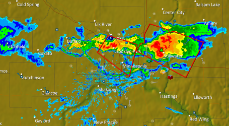
 Sunday Soaker. Doppler radar estimates show 3-4" of rain near Detroit Lakes and Fergus Falls early Sunday morning, nearly a month's worth of rain falling in a few hours. The front fizzled as it approached the metro area, where amounts were under .50"
Folks in Detroit Lakes are still cleaning up from flash flooding, the result of slow-moving and persistent gulley-washers that set up during the early morning hours Sunday. Nearly 4" of rain soaked the area (3.8" to be exact) - streets turned into streams, a few basements flooded, some highways had to be temporarily closed due to wash-outs. The front weakened as it tracked across the metro area, only .1 to .5" of rain for most suburbs and the downtowns, but a soggy start gave way to a few fleeting glimpses of sun. It LOOKED like the sky was going to unload on us - but the real action was 30-80 miles south/east of the Twin Cities.
 Monday PM Thunder Risk. The best chance of a few instability T-storms Monday afternoon/evening will arise south/east of the Twin Cities, but even there the sun should be out part of the day. A partly to mostly sunny (dry) day is expected north and west of St. Cloud, deeper into the dry air, where highs should just top 80. Not a bad way to end a pretty decent 3-day weekend.
The farther north and west you're hanging out in Minnesota on Monday, the nicer the weather will be on Monday, plenty of sun from Leech Lake to the Whitefish Chain to the Detroit Lakes area and Mille Lacs. A stray PM T-storm can't be ruled out from Mankato to the Twin Cities, more numerous showers and storms as you head south/west toward Albert Lea and Winona, closer to that pesky front. Where the sun is out the mercury should easily hit 80 by afternoon, a hint of humidity in the air.
A swirl of cold air aloft (one of these irritating "upper level disturbances") drifts overhead Tuesday, increasing the chance of showers and T-storms by afternoon. After that, a spell of dry weather sets in Wednesday, Thursday and much of Friday - the next weather system arrives over the weekend; most of Saturday looks sunny and pleasant, a better chance of T-storms drifting in on Sunday (it's way too early to try and get specific about next weekend).
For now, enjoy a pretty respectable Monday. Don't forget sunscreen, and whatever you do DON'T let your kids take you tubing. Big mistake.
 Deadly Heatwave? Here are Tuesday's predicted highs for the Mid Atlantic states, 100 for Richmond, Washington D. C. and New York City. Toss in a dew point in the mid 60s to near 70 and it may feel like 105 to 115 in the shade by late afternoon. This may wind up being the hottest week of the summer for much of the east, a newsworthy heat wave is brewing from Boston to Charlotte.
 Crazy Extremes. While the nation's capital braces for triple-digit heat, snow was observed at the summit of Mt. Washington, New Hampshire - unusual but not unprecedented. It was the first time in 2 years - Mt. Washington one of the few regular reporting stations in the U.S. that has EVER reported accumulating snow in July.
Deja Vu All Over Again. As if residents of the Gulf coast weren't already paranoid and shell-shocked enough, still counting themselves (relatively) lucky with the track Hurricane Alex took into the far western Gulf, here comes another area of disturbed tropical weather. According to NHC there's a 50% probability this disturbance will strengthen into a tropical storm in the coming days. The ultimate track? Too early to tell, but steering winds could take this next system into the Gulf of Mexico - again. The latest advisories from NHC are here.
No comments:
Post a Comment