Slight Risk of Severe Storms Friday. SPC has the southern quarter of Minnesota in a slight risk of severe storms - best chance between 4 pm and 8 pm, after the high temperature of the day (upper 80s) - when the atmosphere is most unstable. Storms are forecast to form along a vigorous warm frontal boundary, as the boundary lifts north of MSP temperatures may soar into the low 90s across southern MN Saturday with gusty south winds at 15-25. Looks choppy (again) on your favorite lake.
No Complaints. Most of the state experienced a beautiful Thursday with bright sun, unlimited visibility, and a huge drop in humidity (dew points were in the 50s, meaning less than HALF as much water in the air than Wednesday). Highs ranged from 72 at Grand Marais to 85 in the Twin Cities, 86 at St. Cloud and Redwood Falls. Late-day convective showers and T-showers brushed far northern counties, the .79" of rain at Rochester fell shortly after midnight.

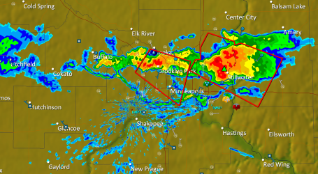
 Wild Wednesday Recap. The NWS issued scores of warnings Wednesday; here is a summary of all the tornado, severe storm and flash flood warnings issued by the Twin Cities office. Tornado warnings are red, severe storm warnings yellow, flash flood warnings show up as green. For a comprehensive summary of the outbreak click here.
 Thumbprint of a Tornado. Tornadoes are too small to show up on Doppler, all we can do is track the parent thunderstorm. Storms that go on to spin up tornadoes also rotate, and this rotation shows up on the Doppler radar's velocity field. On Wednesday the NWS had not only evidence of extreme rotation, but confirmation on the ground from SKYWARN storm spotters nearby. The most accurate warnings have both components: Doppler radar + confirmation from trained professional spotters near the storm, confirming that the circulation is actually reaching the ground.
 Northfield Tornado. The camera was rolling when a tornado passed dangerously close to this storm chaser. Rated R for strong language. The CitizenTube clip is here.
 Wisconsin "Couplet". NWS Doppler radar from the Twin Cities (MPX) detected this vivid velocity couplet, indicating severe rotation just northwest of Ellsworth, Wisconsin, the tell-tale mark of a tornadic "supercell" storm.
 Hayward Aftermath. Was it a tornado or straight-line winds? Hard to tell looking at these damage pics, but whatever it was probably produced winds over 100 mph.
Weekend Summary:
Best Day: Sunday (mostly sunny, probably dry statewide with a slight drop in humidity). Winds: W/NW 10-20. Dew points: 55-65. Hours of rain: zero.
Saturday Storms: Much of Saturday will be dry, if you're outside during the morning, midday or early afternoon odds are in your favor. Watch for strong/severe storms by late afternoon/evening, and some of the storms Saturday night could produce flooding rains.
Winds: S 15-25 (gusty). Dew points: 65-70. Hours of rain: 2-5 (best chance at night).
Better. Much better. Thursday was summer the way it was probably meant to be: blue sky, reasonable humidity levels, a gentle breeze, afternoon temperatures within a notch or two of "normal" (whatever that is). It's the way I want to remember the Summer of '10. In stark contrast to Wednesday, which was the definition of "stinking hot", wild, throbbing clouds mutating overhead. "Partly sunny, with a slight chance of a tornado." Great.
Yesterday marked the midpoint of "meteorological summer", and you may be wondering how we're doing. No? Sorry, I'll try to offer a little perspective anyway. July is running more than 4 degrees F. warmer than average, after a June that run close to 1 F. warmer than normal. Based on cooling degree days (which you can think of as the deviation from 65 F, after you average the high and low for each day) shows that, since June 1, we've all spent about 22% more money than usual cooling our homes and businesses. The tornado count (still preliminary, based on 4 tornadoes Wednesday) stands at 37, although this could go up or down by 1 or 2 tornadoes once the local NWS comes out with their analysis of Wednesday's outbreak. The drought has eased over most of the state, with the exception of the MN Arrowhead, where moderate to severe drought conditions linger. Soil moisture is adequate across Minnesota's agricultural belt, farmers are in pretty good shape - no standing water in fields or massive hailstorms in recent weeks.
 Severe Saturday? Here we go again. I'm starting to sound like a broken record (skipping CD for anyone under the age of 30). Most of Minnesota is in a slight risk of isolated severe storms Saturday, the greatest potential for large hail, straight-line winds and even an isolated tornado or two coming over the southern half of Minnesota. The best chance of watches/warnings: after 4 pm Saturday.
We hang on to sunshine today, highs surging into the upper 80s to near 90 as winds swing around to the southeast, gusting over 20 mph at times by afternoon. The dreaded dew point begins to creep up again today, reaching 60 by midday - by tomorrow your favorite neighbor will be whining about the humidity one more time. All that water in the air will fuel yet another round of storms Saturday, the best chance of strong, potentially severe storms coming Saturday evening and Saturday night. In fact the models are hinting at some 2-4" rainfall amounts up north Saturday night with the possible formation of another MCS system, another mesoscale convective system bubbling up along a vigorous warm frontal boundary. I think most of Saturday will be sunny and hot with a gusty south wind, but have a Plan B (indoors) for late Saturday and Saturday night, when torrential downpours are possible. A wind shift to the northwest should shove the heaviest storms out of the state Sunday, the nicer, drier, sunnier day of the weekend.
 Saturday Downpours? The NAM/WRF model valid around midnight Saturday night (displaying predicted rainfall for the previous 6 hours) is hinting at heavy T-storms popping up late Saturday, possibly an MCS system capable of 2-4" rainfall amounts, the best chance of torrential rains over central and northern MN.
 Looks Like a Weekend. Models print out anywhere from .5 to over 3" of rain Saturday night. The chance of tropical deluges will probably be greater the farther north you go this weekend - I could see some flooding problems, especially across central and northern Minnesota. If you're camping try to avoid a site right next to a small stream - better yet take a battery-operated NOAA Weather Radio so you can hear the warnings, anytime, anywhere.
Next week looks seasonably warm, a string of 80-degree highs the first half of the week (more strong storms may fire off Tuesday of next week). Models are still hinting at more significant heat setting in the latter half of next week as a sprawling "heat-pump" high pressure bubble stalls over the Ohio Valley and the jet stream lifts well north, causing any cooling storms to detour across Saskatchewan, Manitoba and Ontario, Canada, leaving us hot and bothered. Highs could conceivably top 90 almost every day from next Wednesday or Thursday through the first few days of August. Great fun. I predict, more than ever, as we end the month of July the lake will beckon and the pool pass will become a necessity, not a luxury. We're due for some old fashioned heat, and it's on the way.
 Electrifying. The severe storms that swept across western Wisconsin Wednesday evening produced incredible amounts of lightning, nearly continuous cloud to ground strikes. See for yourself here.
 One Expensive Hailstorm. Check out this video of a severe hailstorm that shattered a greenhouse at the University of Calgary, Alberta. A few minutes of golf ball size hail caused an estimated $100,000 in damage, according to the Vancouver Sun.
 How Will a Hurricane Affect the Oil Spill? There's been a fair amount of speculation about what an (almost inevitable) hurricane in the Gulf of Mexico. Scientists are pretty much shooting in the dark - using computers to model the possible movement of oil. The bottom line, this has never happened before, so every scenario is speculative and theoretical, but this article does a good job summarizing the challenges involved. Rick Luettich, an oceanographer at the University of North Carolina, explains the complexities of trying to model the impact here.
* Hurricane Intensity Forecasts May Never Be Feasible. The story is here.
 Big Numbers. With any luck the BP engineers successfully capped the Deepwater Horizon well on Thursday, but even if they pull off this engineering feat, the amount of oil that's been released into the Gulf of Mexico is staggering. The latest estimates here.
 Sea Levels Rising in the Indian Ocean. So much for greenhouse effect "theory", rising sea levels are impacting countries from the Bay of Bengal to Java, and rising CO2 levels are at least partly to blame. The story is here.
 2010: Warmest First Half of the Year on Record. All 10 of the warmest years (worldwide) have occurred in the last 15 years, according to NOAA. At the rate we're going 2010 could edge out 2005 for the warmest year ever observed. We've already surpassed 1998 for the most "warmest months" in a calendar year. Arctic sea ice is 10.6% less than the 1979-2000 average, but (oddly) Antarctic ice is greater than average. A complicated puzzle indeed, but you can read a good recap of the latest findings from msnbc.com here.
 Proof that Vodka and Extreme Heat Don't Mix. This is actually a tragic story: an estimated 200 drowning deaths in Russia have been blamed on overheated (drunk) people trying to find relief in swimming pools and lakes - with tragic consequences. The unbelievable story is here.
Paul's Conservation MN Outlook for the Twin Cities and all of Minnesota
Today: Plenty of sun, warmer and more humid. Winds: W 10-15. High: 88
Friday night: Partly cloudy, slight chance of a T-storm over far southern MN, closer to the Iowa border. Low: 67
Saturday: Hot sun, windy and sticky. Strong/severe storms possible by late afternoon/evening. High: 91
Saturday night: T-storms likely, torrential rains possible, slight chance of flash flooding up north. Low: 71
Sunday: Sunnier, drier, slightly less humid - probably the nicer day of the weekend. High: 87
Monday: Partly sunny, isolated T-storm possible late. High: 86
Tuesday: Humid with more numerous/widespread T-storms likely. High: 85
Wednesday: Sunny and hot. High: 90
Thursday: Dog Days return, hazy sun, hot and humid. High: 92
No comments:
Post a Comment