1:45 pm. Tornado Watch posted until 8 pm - includes most of central MN, including St. Cloud and far western/northern suburbs of the Twin Cities. Isolated, "supercell" thunderstorms capable of large hail and tornadoes may merge into a line of severe storms by evening, capable of violent, straight-line winds over 80 mph, along with torrential rains, capable of flash flooding, maybe some 2-3" amounts in a short period of time. Stay alert, have multiple sources of (media) information - be ready to move to a place of safety if/when warnings are issued for your county - it promises to be a very volatile 4-6 hours.
1:10 pm. Funnel cloud spotted over East Gull Lake around 12:45 pm, moving east at close to 40 mph. People in the Little Falls/Brainerd Lakes/Crosby area should stay alert and be ready to head to safety. We're getting an early jump on tornadoes - I think it's going to be a long day.
Update: 12:45 pm. Severe Storm Warnings for the Brainerd Lakes area - potential for quarter-size hail and wind gusts to 60 mph. The best chance of severe storms in the St. Cloud - Twin Cities metro area will probably come between 5 pm and 9 pm - we can't rule out violent, straight-line winds and a few isolated tornadoes. Stay tuned for more details.
Weather Headlines
* Today: significant risk of widespread severe storms by late afternoon/evening (moderate risk of severe weather from SPC directly over central/southern MN).
* Large hail, violent straight-line winds, even a few isolated tornadoes expected (best chance around the dinner hour). Potential for 3-6 tornadoes, even 1 or two larger, long-lasting EF2+ strength tornadoes possible.
* Today: 7th day this summer season above 90 F.
* NAM/WRF model printing out nearly 2" of rain by breakfast Sunday morning - potential for minor flooding problems tonight.
* Tomorrow: "breath of fresh air" as winds turn around to the northwest with a BIG drop in humidity and a mix of clouds and sun - dry Sunday expected across most of Minnesota.

 Record Hail Event. On July 13 the little town of Napolean was rocked by 5" diameter hail, bigger than softball size, setting a new record for the state of North Dakota. The storms struck overnight, described (at the time) as "cannonball size hail." Yes, that would put a little dent in your paint job. More on this incredible outbreak of monster-hail here.
Paul's Conservation MN Outlook for the Twin Cities and all of Minnesota
Today: Sunny, sticky and hot. A high threat of strong/severe storms by late afternoon and evening, a few will be severe, with large hail, damaging winds, even an isolated tornado. Stay alert after 3 pm. Winds: S 10-15. Dew point: 65-70. High: 92
Saturday night: Severe storms possible evening hours. Heavy T-storms overnight, minor flash flooding can't be ruled out. Low: 69
Sunday: MUCH better! A damp start giving way to plenty of sun, breezy and noticeably less humid. Winds: NW 10-20. High: 84
Monday: More clouds than sun, isolated PM shower or T-shower possible - cooler. High: 77
Tuesday: Warmer with a few scattered T-storms. High: 83
Wednesday: Partly sunny, sticky. High: 89
Thursday: Heating up, lot's of sun, hazy and humid. High: 92
Friday: Lot's of sun, feels like summer. High: 91
 Fine Friday. The sun was out statewide yesterday, highs ranging from 77 at International falls to 90 in the Twin Cities and Redwood Falls to 91 in St. Cloud. A few severe storms bubbled up south of Owatonna by late afternoon, turning tornadic as they swept across Iowa Friday evening.
 Tornado Bulls-Eye. This graphic shows predicted "helicity" around lunchttime today, a 350-450 value directly above St. Cloud and Brainerd, meaning powerful spin in the lowest few thousand feet of the atmosphere, rotation which can (in theory) be focused around a violent thunderstorm updraft, resulting in isolated tornadoes. Meteorologists start to get nervous when helicity values reach 200-300. A value over 400 (combined with other factors) is a red flag that today's storms probably won't be "garden variety."
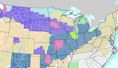
 Ripe. There are 3 "flavors" of SPC severe storm risk: slight, moderate and high. A "high" risk may come around 2-3 times an entire season. Moderate is serious enough, implying a high confidence from severe storm specialists working for SPC/NOAA in Norman, Oklahoma that storms will not only become severe, but conditions exist for severe storms to produce especially violent winds, including tornadoes. The 45% hash mark means a 45% probability of severe weather (58 mph+ winds and/or 1"+ diameter hail) within 25 miles of any town within that region. Translation: batten down the hatches. See the very latest update from SPC here.
Hop up on the severe-storm-treadmill. C'mon, it'll be fun! We can explore the wonders of our favorite basements, listen to lightning-induced static on the AM Radio, or maybe tune in the funky, robotic voice warbling out of the nearest NOAA Weather Radio, enjoy a siren serenade together. The PERFECT set-up would be a big-screen HD, web-enabled TV under the stairs, maybe slip in a Blu ray disk of "Twister" while we sit....and wait...and wonder...and worry...and fidget, hoping this won't be that one-in-a-million fluke where there's a 30 second rumble and roar, and precious little left when we wander back up the stairs?
Will today be the day we win (lose?) Minnesota's Tornado Lotto?
Odds are (99.99%) your home will still be there tomorrow. The odds of you (or any of us) encountering a tornado are slim to nil, but not zero. SPC has raised the severe threat to "moderate" over central and southern MN. Once again we're faced with a witch's brew of ingredients: low-level moisture (dew points may hit 70 by evening), strong instability (unusually cold aloft) and powerful wind shear - what meteorologists call "helicity" (which sounds like a great name for a cat, come to think of it). I fear I may have gotten too much sun yesterday. Helicity is a measure of spin, or "shear", winds changing direction and speed as you rise up through the atmosphere. The stronger (and more varied) the winds in the lowest few thousand feet of the atmosphere, the greater the potential for a severe storm to focus all that spin and conjure up a tornadic circulation that reaches the ground, on the boundary between a violent updraft - air shooting straight up at 100+ mph, and a rain/hail-cooled downdraft.
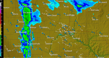
Plan on watches/warnings later today - I have a strong hunch that SPC will issue a tornado watch for the mid afternoon through evening hours. Storms may fire up near Alexandria or Wadena, then race to the east/southeast at 30 mph. Personally, I'd go about my normal activities today (try to front-load your outdoor stuff into the morning and midday hours) but keep an eye on the sky after lunch, have multiple safety nets (ie stay tuned to radio, TV, check warnings on your smart phone). Don't just rely on the sirens, whatever you do - bad idea. If you're heading out later in the day calmly ask yourself "where would you go if a warning was issued right now - here?" Scope out the venue - can you get below ground, below grade? Are you exposed to outer walls, windows or glass nearby? Can you find a small, windowless room (with nothing flying off the shelves?) Maybe it's just because I'm a weather geek, but on the big tornado days I'm always more aware of my surroundings, and where I could dash if the REAL DEAL unfolded overhead. The day you say, "oh, they're full of horse-hooey, they blab about tornadoes, we NEVER see tornadoes here..." THAT will be the day Mother Nature may wipe the smile off your face. People in Wadena didn't think they'd actually see an EF-4 tornado back on June 17. Folks living near Northfield probably didn't expect an actual tornado to skip across lawns and fields in town last Wednesday. Tornadoes always happen "somewhere else", right?
I'm pretty sure Minnesota will experience a handful of tornadoes later today, maybe as many as 3-6 separate circulations. Based on the dynamics and meteorological set-up there probably will be damage - hopefully no injuries, but every set-up like this I hold my breath, praying that any tornadoes strike fields, not towns - hold my breath that weather-wise Minnesotans will plug into local media and take any warnings seriously - not blow them off. BTW, a friend pointed out the obvious: we shouldn't be too shocked about the recent rash of severe storms, coming after a strong El Nino earlier this year. As it turns out, El Nino events are often followed by unusually busy severe storm seasons in Minnesota. This is vaguely reminiscent of 1998, another big El Nino year, in fact that was the Mother of All El Nino's, the strongest ever recorded.
The sun should be out during the morning, midday and early afternoon hours, and the good news: winds won't be as strong on your favorite lake, blowing from the south at 5-15 mph. You will feel the humidity rising, no question about that, and if the sun is out for at least 3-5 hours (likely) we should see low 90s by 3 pm or so. That's when the storms may begin to fire off, mid or late afternoon, reaching peak intensity around the dinner hour, possibly mutating into an MCS, a mesoscale convective system, during the evening/overnight hours. The WRF/NAM prints out roughly 2" of rain for the metro area Saturday night, which (if it verifies) would imply flash flooding in some communities. With a dew point near 70 the atmosphere will be supercharged, energized, plenty of fuel for severe thunderstorms by late afternoon, and potentially torrential rains later in the evening.
Sunday will be a HUGE improvement as winds whip around to the northwest, pushing heavy storms (and stifling humidity) into toward Chicago - leaving us with plenty of sun and nearly HALF as much water in the air by Sunday evening. Count on blue sky much of the day (after a soggy start) with highs in the low to mid 80s, and a stiff wind blowing from the northwest at 10-20 mph. Sunday will restore your faith in a Minnesota July: sun, without the scattered tornadoes thrown in.
An isolated T-storm may pop late Monday, again Tuesday, but the rest of the week looks dry and increasingly hot, a few 90-degree days returning by Thursday and Friday. Not sure if this will turn into a full-blown heat wave, but I could see at least 4-5 days above 90 during the last week of July and the first few days of August. Hardly a shock.
Have fun, with a little planning and a few extra precautions we'll all be just fine today. Just know the sky may turn ugly by late afternoon. Know where all your family members are, in fact this might be a good time to review tornado safety rules. They may laugh when you bring it up, but I suspect they won't be laughing around 5 pm today. It's ripe for severe weather, probably nothing like June 17, but a few tornadoes are likely later today. I wish we had the technology to try and pin down precisely where - that capability (more than an hour in advance) probably won't happen in our lifetime - it will require more frequent/numerous weather observations and computer models an order of magnitude more powerful than anything we're using today. Maybe our grandkids will look back and laugh at how "crude and rudimentary" the tornado forecasts were back in 2010. I sure hope so...
 Kiester Revisited. Yesterday a friend forwarded this amazing footage of the multi-vortex tornado that hit the Kiester, Minnesota area back on June 17. You can see 2-3 tornadoes, all rotating around a common center - something you'd expect to see in Kansas, not Minnesota.
 Drought Update. According to the U.S. Drought Monitor moderate to severe drought conditions linger over the Minnesota Arrowhead, but soil moisture is more than adequate across most of Minnesota. It's still too dry over the eastern suburbs of the Twin Cities and north of Brainerd. That may change by late tonight.
 Severe Clear. This high-res NASA (Terra) satellite image was taken around midday Friday, with 1000 meter resolution. What struck me (from an altitude of 220 miles) is the obvious impact of development, the urban sprawl around Chicago and Milwaukee, the string of towns showing up along the interstates. The patchy clouds just south of MSP mark a weak frontal boundary that went on to spark a few isolated severe storms later in the afternoon west of Rochester. The latest NASA "MODIS" image is here.
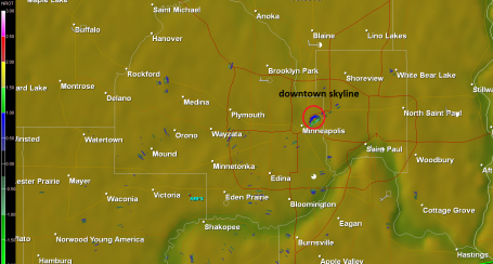
 A Real Sizzler. By now you know that 2010 is on track to be the warmest year since accurate weather records were first started in 1880, according to NOAA. A fluke or a trend? Click here to read a good summary of the hot weather gripping much of the northern hemisphere. More statistics from NOAA here.
 Typhoon "Conson" With winds of 75, "Conson" is a minimal typhoon (same thing as a hurricane) but it still poses a significant threat to southern China and Vietnam. The latest from the BBC is here.
 No More Vacation: How Technology Is Stealing Our Lives. O.K. This has nothing to do with weather, but it struck a cord with me. We have all these new fancy, high-tech ways of communicating, keeping in touch with friends, family (and the office). Technology was supposed to liberate us, instead it seems to be enslaving us. We can never fully disconnect from the grid - we have to get our information fix, we have to check our e-mail, tweets and FB posts, we can't possibly go a few hours without logging on and checking in. Somehow we've gotten to the point where everyone expects everyone else to be available, almost 24/7. "Why didn't you return my text?" Weekends, vacations - doesn't matter, we're all on-call, expected to drop everything and "stay connected" anytime, anywhere. Being "out of touch" has become a sin. How did we get to this place in time? I sense a backlash brewing - and I'm not the only one tempted to toss my "smart" phone into the nearest lake. A good summary of the problem from Salon here.
 Massive Tree Loss in the Amazon. A single violent storm may have brought down as many as a BILLION trees in the Amazon in 2005, researchers are reporting. This wasn't a hurricane, but a line of severe thunderstorms with unusually fierce straight-line winds, capable of bringing down 100-200 year old trees, more evidence that the frequency and intensity of severe local storms seems to be ticking up worldwide. The story from sciencedaily.com is here.
 Interactive Google Map Shows Possible Impact of 4 C Temperature Rise. Click here to see the potential effects of a 7-8 F temperature spike on the planet, a worst-case scenario by the year 2100, just about the time our grandkids walk outside, scratch their heads in wonder, and how they inherited such a mess. If you have Google Earth installed on your computer the KML file is here.
No comments:
Post a Comment