
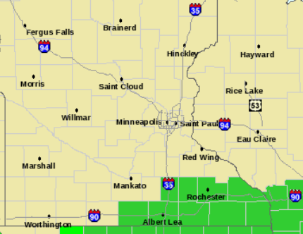
Flash Flood Watch. The local NWS has issued a flash flood watch for far southeastern MN, where soil is saturated from recent heavy rains (2-3" fell overnight). Severe storms are forecast to stay south, over Iowa, where the airmass is still hot and sticky. The greatest potential for flash flooding may come Friday night and early Saturday as a drier front approaches from Canada.
"Thunder-wear Alert." I'm writing this at 11 pm Wednesday night. Storms are rumbling across South Dakota into southwestern MN - the model output (above) valid midday Thursday shows a huge bulls-eye of heavy rain over central and southeastern MN, maybe an inch from St. Cloud to the Twin Cities, as much as 2-3" over far southern MN before skies brighten around midday. Go ahead - take something waterproof to work. You'll be glad you did.

 Wednesday Magic. What a day, summer the way it was meant to be at roughly 45 degrees north latitude. Blue sky, light winds, reasonable humidity levels (dew points in the 50s across most of Minnesota). Highs ranged from 79 at Hibbing to 86 at St. Cloud, a toasty 88 in the Twin Cities.
I've had a lovely day - wrestling with my laptop (PC - sadly). I have Macs (mostly for creative, photos, videos) and PC's for the day-to-day stuff (some of the most cutting edge Doppler radar programs we use only run on PC's). And yes, I've tried the "emulation" programs that allegedly allow Macs to run (most) PC programs. It's a Direct-X issue, but I'm going into far more detail than you need (or want) to know. Suffice to say I am totally dependent on computers to monitor current weather, check models of future weather, and then try to communicate to the public from WeatherNation. When your computer is sickly, running slow or freezing up, life is extra-miserable. A little like life in general - you don't realize how great it is to be healthy until you come down with some nasty bug and you're flat on your back. I hope your favorite computer is in better shape. And by all means learn from my mistakes and BACK UP your PC or Mac! It's like an insurance policy, you only need it when you REALLY need it.
Before smoke starts to come out of my (%^(*^%$!@!!!) PC let me see if I can bang out an entire blog, get the essentials out. This will be in bullet-point form, like a Powerpoint presentation, only worse.
* Take An Umbrella Today. It's going to rain (hard) today, maybe an inch or more of rain (best chance during the morning hours).
 Slight Risk. SPC has most of central and southern MN and a big chunk of southwestern WI under a "slight risk" of isolated severe storms. The best chance of large hail and damaging straight-line winds? Around the dinner hour. Wind shear isn't terribly impressive - so the risk of tornadoes is considerably less than last Saturday. I can't rule out an isolated funnel or two, but this does not look like a widespread tornado outbreak right now.
* Severe. Yes, some of the storms bubbling up later today may reach severe limits (58 mph+ winds and/or 1" diameter (quarter-size) hail. Any severe weather will affect a tiny percentage of Minnesota, less than 1% of the area - but it's impossible to tell which counties will get hammered. Overall the risk of severe should increase the farther south you go to the Iowa border. So please - whatever you do - avoid the Iowa border.
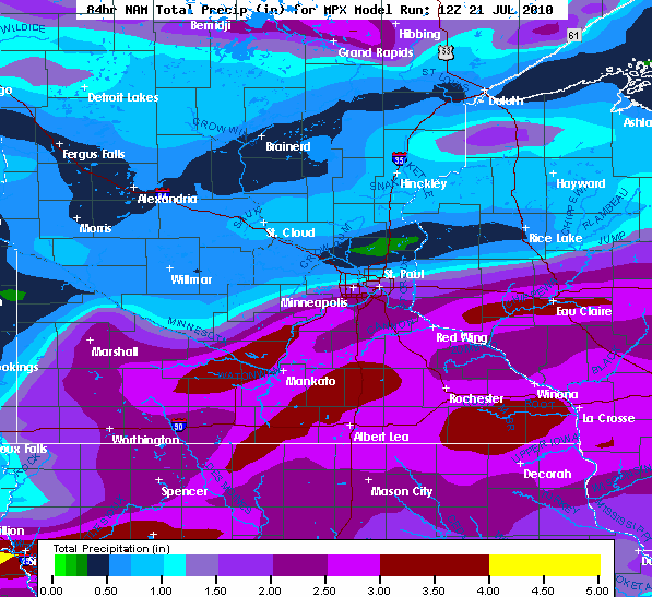 Watering Optional. The best chance of a soaking will probably come south of the Minnesota River, where models are printing out 2-3.5" of rain, much of that coming this morning, another wave of (potentially severe) storms rumbling into town this evening.
* Lazy Front. This next frontal boundary is moving slower than expected - meaning showers and scattered storms will spill over not only into Friday, but possibly part of Saturday as well.
* Disappointing Saturday. Another half inch to inch of rain may fall Friday night into Saturday. Yes, have a Plan B for part of the day Saturday as that (tardy) front sloshes across the state.
- 3-6 hours of rain possible Saturday, .5 to 1" rain. Winds: SE, becoming NW (10-20) pm hours. Not a great day. Sorry.
* Sunday DEFINITELY looks like the better lake/pool day at this point as high pressure builds in from Canada - less wind, BIG drop in humidity and enough sun for a respectable burn.
- Hours of rain: 0. Winds: N/NE 5-10.
 Salvageable Sunday. Saturday's forecast is a bit of a disappointment (this is our worst fear as meteorologists - all the models hinting that systems will keep clipping along, only to find out - on Wednesday night - that the front is, in reality, going to slow down, and clip part of Saturday). Maybe last night's computer run is out to lunch - maybe the front will sail along faster, promising a nicer Saturday than expected. Maybe. But don't count on it.
Paul's Conservation MN Outlook for the Twin Cities and all of Minnesota
Today: Heavy thunderstorms this morning (possibly 1" of rain metro, maybe 1-3" far southern and southeastern MN). Skies brighten this afternoon - a few severe storms may develop by late afternoon/evening. Winds: SE 10-20. High: 82
Thursday night: Lingering showers and T-storms. Low: 70
Friday: Still unsettled, another shower or T-storm. High: 84
Saturday: Not great - more clouds than sun with a few hours of showers/storms. High: 83
Sunday: Better. Mostly sunny and less humid (with less wind). High: 85
Monday: Blue sky, still very pleasant. High: 85
Tuesday: Partly sunny, a few passing T-storms. High: 83
Wednesday: Mix of clouds and sun, more humid. High: 87
 Bonnie? The tropical disturbance over Hispaniola is still disorganized, conditions not ripe for imminent intensification, although there's at least a 40% probability that this tropical "wave" will still strengthen into Tropical Storm Bonnie by Friday. The latest from NHC is here.
 "Bonnie's Track?" Intensity is up in the air, but if, IF, the disturbance strengthens into Tropical Storm Bonnie this is the projected path. Check in for the latest track predictions. Yes, we get storms in Minnesota, but at least our storms DON'T HAVE NAMES. Track courtesy of NHC and Ham Weather.
 It's Baaack. El Nino officially fizzled during the spring, and now there's growing evidence of a cooling trend in the Pacific - which could imply a colder winter coming up across much of North America. We'll see. The story is here.
 Hail - Yes? It's not snow, but a freak (30-45 minute) hailstorm that swept across Calgary, Canada. The video is here.
* Over 700 People Killed In China Flooding, Worst Since 1998. Historic floods are sweeping across southern China - the latest information here.

* Overcome By Heat & Inertia. The New York Times has a story on the record heat registered in the Big Apple in New York. Much of the east has been baking through what may go down in the record books as the hottest summer since 1988. Will a climate and energy bill get passed? Who knows - but it's looking increasingly doubtful that there's the political will to do anything about rising temperatures. The story is here.
A Russian Warning on Retreating Arctic Ice. Based on satellite observations arctic ice shrank to 4.2 million square miles in June, the least ice ever observed since the arctic ice cap was first measured by satellites in 1979. Russians scientists are concerned - the story here.
No comments:
Post a Comment