* Few severe storms possible Saturday evening, best chance north/west of the metro area.
* 2-4" rains may swamp the metro area tonight from an "MCS System" - flash flooding can't be ruled out.
* Near 90 Sunday afternoon with a heat index near 100 predicted.
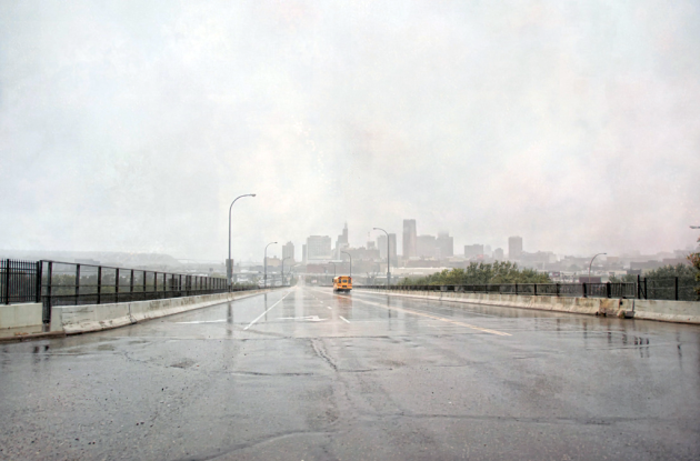
No Need To Water Anytime Soon. Wow. Check out the rainfall BOMB centered on MSP, most of the 3-4" of predicted rain forecast to fall tonight. Not sure if we'll really see that much, but some 1-2" amounts seem like a pretty sure thing - (big) puddles Sunday morning giving way to enough sun for highs in the 90-92 range. Factor in a dew point near 70 and it may feel like 95-100 Sunday afternoon. Get thee to the lake!
The rumble of thunder on the horizon - the colorful blobs mutating on Doppler - a sweaty breeze and churning, black & blue clouds scraping overhead can mean only one thing: it's a weekend.
Right on schedule here comes another noisy parade of showers and T-storms, the chance of getting wet increasing as the day wears on (you didn't actually have anything planned outdoors around the dinner hour, did you?) All is not lost - we're not talking all-day drenching here, but a few hours of (hard) rain, spiked with thunder and lightning, seems like a pretty sure bet later today and tonight as the next front sloshes across the state.
 Forecast: Choking Smoke. Moscow is under siege - hundreds of fires outside Russian capital are burning out of control, producing a thick blanket of smoke that has choked the city. Flights have been grounded, visibility down to a few yards in parts of the city. Authorities are warning residents to stay indoors as much as possible - those brave enough to hit the streets have been seen wearing gas masks to keep from gagging. The story is here.
Paul's Conservation MN Outlook for the Twin Cities and all of Minnesota
Today: Partly sunny, becoming more humid - strong/severe storms are possible by late afternoon and evening. Winds: S 10-15+ High: 85
Saturday night: T-storms likely, locally heavy rain. Low: 73
Sunday: Sunnier, hotter & drier statewide (isolated storms possible far southern MN). Winds: W/NW 5-10. High: 91
Monday: Sticky sun - hot (isolated storms can't be ruled out). High: near 90
Tuesday: More numerous T-storms, some heavy. High: 88
Wednesday: Intervals of sun, dog days linger. Still humid. High: near 90
Thursday: Partly sunny, slight chance of thunder. High: 91
Friday: Blue sky, slightly cooler and less humid. High: 85
 Dog Riding a Lawn Mower. Random. But funny. Worth a look. Potentially forward-able.
 Fine Friday. What a day - blue sky, dew points in the 50s (more like early September) highs ranging from a brisk 65 at Grand Marais to 82 in St. Cloud, 85 in the Twin Cities.
 Saturday Fireworks. Much of Minnesota is in a slight risk of severe storms, a 30% risk of severe weather within 25 miles of any point in central Minnesota - best chance late afternoon and evening hours. The latest NAM/WRF model prints out about a half inch of rain tonight.
 Red Blobs = Plan B? The latest NAM/WRF model shows the strongest storms mushrooming across far western/central MN between 5 pm and 10 pm - they may weaken (slightly) before reaching St. Cloud and the Twin Cities. The greatest risk of (isolated) severe storms appears to be from Alexandria and Detroit Lakes to Brainerd and Little Falls around the dinner hour. Stay tuned...
No Saturday would be complete without a (slight) risk of a few severe storms - the greatest risk appears to be across central Minnesota around the dinner hour (give or take 3 hours) when the atmosphere will be most unstable, irritable, capable of turning an ordinary garden-variety storm into a "supercell" capable of large hail and damaging winds, even an isolated tornado. Odds favor watches and warnings later today - keep an eye on the sky and be ready to make a mad dash anytime after 4 pm or so.
 A Threat to Whales and Cruise Ships. Tropical Storm Colin may brush Bermuda with 40-50 mph winds as it curves north, steering winds aloft keeping the storm well away from the east coast of the USA.
* Forecasters: Active Hurricane Season Still Likely. We've gotten off to a quiet start, but hurricane season peaks September 11. Ocean water temperatures in the Atlantic and Caribbean are still unusually warm, wind shear is diminishing - breeding more favorable conditions for hurricane formation in the weeks to come. That's why you break on Caribbean cruises in late August and September. An update on hurricane potential for 2010 is here.
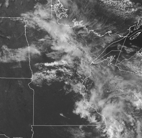
 Smoke (and a little lake effect). Look carefully just south/west of the Twin Cities and you can see a streak of smoke pushing from northwest to southeast across Minnesota. Notice the lack of clouds just downwind of Mille Lacs, the Whitefish Chain, Leech and Red Lake. Water temperatures were 15 degrees F. cooler than surrounding land temperatures - inhibiting growth of popcorn cumulus clouds. It's just the reverse of what happens in late autumn and early winter, when icy winds passing over the relatively warm waters of the Great Lakes spark "lake effect" clouds and snow showers just downwind. The latest NASA "MODIS" high-res satellite image is here.
 Canadian Brushfires. NOAA tracks not only weather, but volcanic eruptions and fires that flare up across North America. Scores of fires are burning across central Canada, prevailing jet stream winds whisking smoke from these fires hundreds of miles downwind over the Midwest and Great Lakes states, lowering visibility, creating spectacular sunsets. I may have been imagining it, but I swear I smelled smoke yesterday shortly before sunset. The latest NOAA tracking map from the SSD Fire Detection Program is here.
Sunday should bring our 11th day above 90 so far this summer season, a few 90s are possible next week, Minnesota on the northern periphery of a bloated, slow-motion heat wave that has been gripping too much of America for far too long. Friday heat advisories were issued as close to us as western Iowa - I don't think we'll see any dangerous, sustained levels of heat and humidity, but we'll get a taste of the good 'ol dog days next week. Why "dog days"? It has nothing to do with panting like a dog, everything to do with the dog star "Sirius", the brightest star in the late-night sky. The ancient Greeks noticed that the hottest weather tended to occur in late summer, when Sirius was visible along with the rising sun. They theorized that this "extra sun" contributed additional heat, thus the term dog days. Almost interesting, huh? Maybe not.
While we dodge errant late-day storms and ponder a grumbling sky much of next week (good chance of T-storms Tuesday and Wednesday as temperatures nudge 90 each day) much of the northern hemisphere is sweating through the hottest summer in recent memory. A Kentucky-size swath of Russia is enduring withering drought - along with the hottest, driest weather in 130 years of record-keeping. Hundreds of fires (most burning out of control) have forced residents of Moscow to take extreme measures. Officials are warning locals to stay indoors, not very practical for a big, bustling city of 5 million people. Thick, debilitating smoke from forests have made the air almost unbreathable - people are wandering the streets of Moscow wearing gas masks, darting from one building to the next. Not good.
 Hottest Year? 2010 is still on track to go down into the record books as the warmest year ever recorded. The past decade has been the warmest on record, according to climate scientists in 48 nations. More from NOAA here.
* NOAA: Don't Believe Skeptics - Global Warming is "Undeniable." I don't think the scientists at NOAA can make it any clearer than this.
Meanwhile an interesting post from Weather Underground founder Jeff Masters caught my eye. Based on his research 2010 is now tied with 2007 as the year with the most national extreme heat records - 15 in all. During 2010 there has been only 1 country that has experienced its coldest temperature on record. A total of 74 separate countries have established "extreme hottest temperature records" since 2000 (affecting 33% of all the countries on the planet). During this same period only 14 countries have set extreme coldest temperature records - about 6% of all countries. 5 times more all-time record highs than record lows since 2000. Some of this may be El Nino, but if the climate was static (or we were really cooling, as some skeptics would lead you to believe) we'd be witnessing nearly as many record lows as highs. That has not been the case. So it would appear that heat records are an accelerating trend, not a fluke or a passing aberration. Something is going on. Too many coincidences. Historic flooding in Pakistan, China - and the USA hasn't been spared: Nashville, Oklahoma City, Arkansas.
 Comparing 2010 to 2009. Much of the Midwest is experiencing a much warmer, wetter year than last year, according to NOAA records.
* Hot Weather Records Fall Left and Right. Here's a good summary of what's happening - worldwide - from the Capital Gang in Washington D.C.
Sunday the heat index in Gulf Shores Mississippi was a dreadful 118 (that's what it FELT like, combining heat with humidity). Just offshore a weather buoy in the Gulf of Mexico registered a water temperature between 90-94 F. On the very same day Lefconica, Cyprus registered the hottest temperature ever recorded: 115.9 F. North America experienced the second warmest July in 50 years, according to NOAA. Again, any one data point or observation proves nothing, but you have to step back, connect the dots, try to take in the big picture, separate daily "weather" from longer-term "climate", which spans many years, decades, centuries and millenia. Is the 30-year spike in global temperatures a fluke? Perhaps. Maybe it is a "natural" cycle. Time will tell, but the warming trend (and surge in "extreme weather events", flooding, extreme storms, etc) is coming on the heels of a 38% increase in greenhouse gases (which nobody disputes). It's either the Mother of All Coincidences - or evidence of larger trends. It's a puzzle, a climate puzzle, and many of the pieces have fallen into place. Experts with a grasp of global trends, chemistry, oceanography and physics are concerned that by the time the last piece of the puzzle falls into place it'll be too late to do anything about it. That's the paradox. Do we do something now, take out an insurance policy, or wait?
Time will tell, but something tells me we're just witnessing the tip of a (melting) iceberg. Expect more record heat, more drought, more fires, more historic 1-in-500 year floods coming with disturbing regularity.

Climate Markers. Climatologists look at a variety of "markers" to determine what's happening with Earth's climate system. For more on the detective work involved click here.

12 Events That Will Change Everything. Although not directly weather or climate-related, I thought this was an eye-opening article, a worthy ready from Scientific American.
 Greatest Sunsets of All Time? That's a mouthful, chances are you've taken some spectacular sunset shots of your own - don't mean to insult you. But this is a pretty amazing collection, courtesy of those sunset-loving geeks over at Gizmodo.
No comments:
Post a Comment