* 3.42" at Eden Prairie, 2.47" MSP International Airport and 1.34" rain in St. Paul.
* Patchy dense fog gives way to sunshine by late morning/midday - potential for 90 degrees (but no severe storms expected).
Radioactive Smoke? Just when you thought things couldn't get any more apocalyptic for Russia. A thin layer of (once-lethal) radioactivity within a few hundred miles of the crippled Chernobyl nuclear plant is in danger of being swept up into the acrid clouds of smoke, as flames continue to race across Russia. Chernobyl is the site of the world's worst nuclear accident and partial meltdown 24 years ago. Local officials fear that radioactive smoke from the contaminated region could extend hundreds of miles downwind. The story in the New York Times is here.

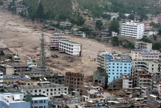
Epic Floods. 2010 is turning into the Year of the Flood. All across the planet the frequency and intensity of flooding seems to be surging. This image is from Zhouqu, China, in the northwest part of the country, where the death toll is approaching 1,000 with hundreds missing. One entire side of a hill collapsed, sending a wall of muddy water downstream into the city. The story is here.
 "Pakistan's Katrina". That's what they're calling the historic flooding across Pakistan, the worst on record. At least 1,600 Pakistanis have lost their lives, over 2 million people have been displaced by the persistent floods, and the rain continues to fall. The story is here. Jeff Masters over at Weather Underground has more details on the record monsoon gripping Pakistan and India on his excellent blog.
* Massive Flooding Around the World Brings Misery to Millions. A significant percentage of the northern hemisphere is being impacted by severe flooding, impacting millions of people in dozens of countries from China, Pakistan and India to Germany and parts of the USA. The story is here.
* Extreme Weather Fuels Debate Over Global Warming. Coincidence - or symptoms of a bigger problem? The persistence of the heat in Russia and the magnitude of the flooding in Pakistan and China is unprecedented. Climate change is an incredibly complex puzzle, rarely is anything ever black or white, but the uptick in floods, droughts and accelerating ice melt over Greenland and the Arctic are all consistent with a warming atmosphere, one that holds more water vapor, in essence loading the dice in favor of more extreme events. The story is here.

* Analysis: Pakistan Floods, Russian Heat Fit Climate Trend. Insurance reinsurer Munich Re has a massive database that shows the number of extreme weather events (floods, wind storms, droughts worldwide have tripled since 1980. Fluke or trend? Some additional information from Reuters is here.
Paul's Conservation MN Outlook for the Twin Cities and all of Minnesota
Today: Much-needed break. Foggy start, then plenty of sun, but dry and quiet. Winds: SW 8-13. High: 91
Wednesday night: Mostly clear and mild. Low: 73
Thursday: Sunny start, still hot and sticky. A few late-day storms may be strong/severe. High: 92
Friday: Numerous showers and T-storms, some heavy. High: 85
Saturday: Partial relief. Mix of clouds and sun, breezy and cooler with a BIG drop in humidity. A few PM showers may pop up north. Winds: W/NW 10-20. High: 82
Sunday: Plenty of sun. PM clouds, maybe a shower or sprinkle up north. Winds: NW 10-15. High: 81
Monday: Lot's of sun, less wind - comfortable humidity levels. High: 79
Tuesday: Sunny start, then increasing clouds. High: 78
Yesterday was a first: 3 separate thunderstorms in one day, at least at my house. Good grief! A day of sun, a day of severe, back to sun, followed by severe. We've been stuck in a bizarrely predictable severe weather cycle, wild T-storms spaced about 2-3 days apart since mid June as Minnesota teeter-totters on the northern fringe of blast-furnace heat gripping much of America. Yesterday's noisy storms and grumbling skies are now pushing to the east into Wisconsin, we should salvage a sunnier, quieter, drier Wednesday with enough sun for upper 80s, maybe a 90 close to home with a very slight drop in the dreaded dew point - but it will still be sticky enough out there to work up quite a sweat.
Thursday looks hotter, low 90s likely with a heat index approaching 100 once again - before yet another round of strong/severe storms rumble into town by afternoon or evening. What a shock. Thundery weather lingers into part of Friday, but the models are pretty consistent in bringing some serious relief into town over the weekend as winds finally swing around to the northwest for a sustained period of time. You'll start to feel a significant drop in humidity levels Saturday with intervals of sun, a few pop-up instability showers sprouting over the northern half of MN Saturday afternoon as winds gust to 20 mph. Not a perfect day on your favorite lake, I fear, but not an all-day rain either. Sunday still looks better at this point: more sun (statewide), a bit less wind, dew points in the 40s (north) and low 50s (south), less than HALF as much water in the air as we'll have floating over our heads today. We can't rule out a few stray showers over far northern MN late Sunday, especially near the Canadian border, but most of the day looks pretty nice from Lake of the Woods on south to the Iowa border.
We'll all be breathing easier early next week, a string of days with highs in the 70s, dew points in the 50s - another atmospheric tug-of-war playing out directly overhead sparking another spirited round of showers and T-storms late Monday into Tuesday. For now enjoy a break in the (thundery) action, although I hardly call a high of 91 a "break." At least you won't have to make a mad dash indoors later today. That's progress, I guess.
 Brewing Tropical Storm? NHC is keeping a close eye on a strong tropical depression forming just south/west of Naples and Ft. Myers, Florida. The storm has a closed circulation and water temperatures in the Gulf of Mexico are in the mid to upper 80s, warm enough for additional strengthening. There is a 70% probability this system will strengthen into a tropical storm within the next 48 hours - the latest from NHC, the National Hurricane Center, is here.
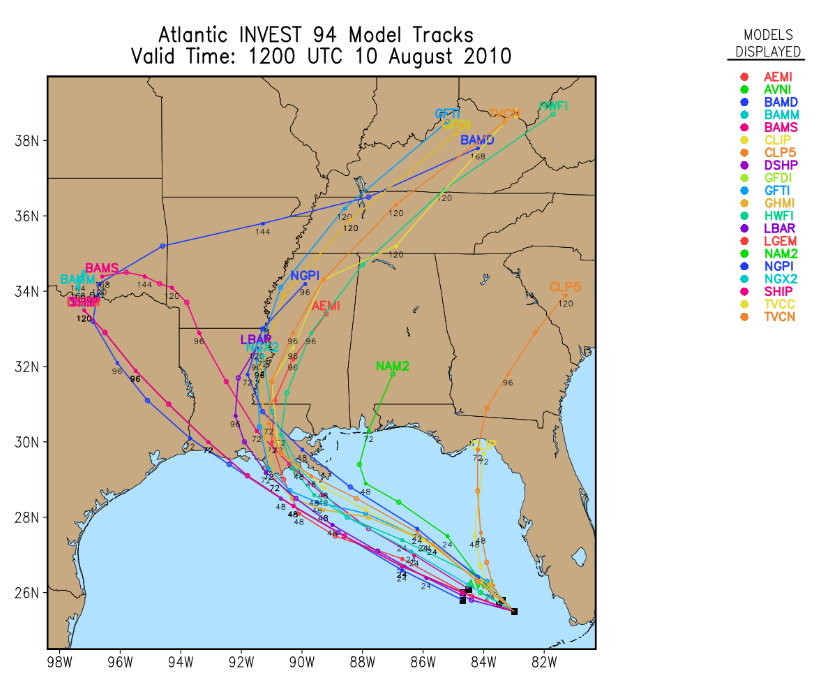 Potential Track. NHC looks at 20 different models when trying to determine where a tropical system is heading, and the models are in pretty good agreement that Louisiana may be in the cross-hairs. Historically weather models do a MUCH better job predicting the track than the intensity - it's still unclear whether this storm will strengthen to hurricane status before hitting the Gulf coast. The latest computer (spaghetti) model track prediction is here.
 NASA's HIRAD Instrument to Provide Unique View of Hurricane Wind Speeds. NASA is equipping 3 specially-equipped planes to fly into hurricanes later this summer and early autumn for the most complete perspective of wind speeds within a storm ever gathered. Their goal: get a better understanding of the complex spiral wind bands within a hurricane, how "eyewalls" form, dissipate and reform, and hopefully - arm meteorologists with better physics to plug into their computers to handle the biggest challenge in hurricane forecasting: predicting whether a storm will strengthen or weaken, and how rapidly. The story from NASA is here.
 Wettest Year on Record (so far) for Des Moines. Think it's been wet here? So far the Twin Cities has picked up 16.38" (2.45" less than normal) so far in 2010. That compares to a whopping 39.03" at Des Moines, more than 19" wetter than average for an entire year. Records go back to 1878. Source: DSM National Weather Service.
 Smog From Raging Wildfires in Moscow. The siege of Russia continues - record heat, drought and wildfires have left at least 5,000 - 15,000 people dead. A cooler front may drop temperatures into the 80s by the end of the week, providing slight relief from the worst of the heat. Home video of the eerie conditions gripping Russia's capital is here.
* Climate Change Partly To Blame For Sweltering Moscow. A story from the BBC here.
 Travel Alert. The U.S. State Department is warning travelers to Russia to take extra precautions, due to heat, drought and smoke from over 500 wildfires that continue to burn. More information is here, including NASA imagery of the fires ringing Russia's capital. Wheat fields covering an area roughly the size of Kentucky have been impacted by severe drought, the worst in nearly 1,000 years according to some local experts - the cost is already $15 billion and rising. Here is another YouTube clip showing the local conditions.
 Think This Summer is Hot? Get Used To It. Delaware and Rhode Island just experienced their warmest July on record. For every other state from Maine to Florida it was one of the top 10 hottest July's since 1880. NOAA researchers believe the suffocating heat may become the "new normal" by mid century. This may just be a preview of coming attractions. The story in USA Today is here.
 Send In The Clouds. Water vapor has increased - worldwide - by about 4% in the last century. Warmer air can hold more water - in theory this should produce more cloud cover, but the physics involved is still unclear. Will we be seeing new kinds of cloud formations in the years ahead? Click here to read an interesting story on the cutting edge of cloud research.
Greenland Ice Sheet Faces "Tipping Point" Within 10 Years. Yesterday a team of scientists told Congress that a temperature rise of only 2-7 C (about 4-13 F) could melt most of the ice on Greenland, raising water levels by as much as 23 feet - within our lifetime. The trends are alarming, the recent calving of a massive sheet of ice off the Petermann glacier another symptom that Greenland is warming (and melting) faster than most of the computer models had previously predicted. The story in the U.K.'s Guardian is here.
 The BP Cover-up. Is the disaster in the Gulf of Mexico really winding down? I certainly hope so, along with millions living along the Gulf coast. But a number of scientists & oceanographers are very concerned about what's really happening 1-2 miles beneath the water's surface. I'm not big on conspiracy theories, but click here for an interesting read.
No comments:
Post a Comment