
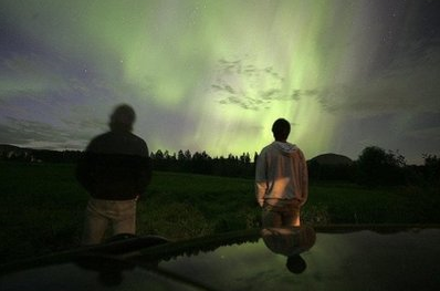
"C'mon man, you're jumping the gun. There is another good month of water skiing/wakeboarding ahead of us, depending of course on what those crazy weather guys have in store. I don't have a dry suit, but I'm good to a water temp of about 52 - 54 degrees with a 3mm wetsuit. I attached a pic of my boat and one of me making some turns on Tanager around sunset a couple of weeks ago. The water temps have been holding seady at right around 64 degrees, whic is where Mtka is today...For some reason in early September the water temps dropped fairly quickly from the summer 70s down to that current mark. If that trend had continued at that early September pace my fall season would have been cut shorter than I like. Despite all the rain and fresh surface water though, the local lake temps have been holding steady for several weeks now. That's good news. The water can go 10 degrees lower before our boat gets winterized!"
Wow. I start to complain when the water temperature falls below 75 F. I'm impressed. Now that's a die-hard ski buff. Yep, at this rate David and other hearty Minnesotans will be water-skiing into mid October. A cool front is scheduled for Friday and Saturday (it will feel more like mid/late October out there), but we warm up again next week, a string of 60s, maybe a few more 70s. Nothing resembling a "cold front" is in sight through the third week of October.


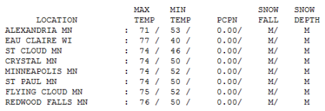
Definition of "Perfect"? Could the weather have been any better yesterday? Don't think so. How are you supposed to "work" or "study" when the sky floating overhead is so blue, lukewarm and....memorable? I have a hunch job productivity and test scores suffered on Wednesday. Highs ranged from 71 at Alexandria to 74 in St. Cloud and the Twin Cities, 76 at Redwood Falls.
* On September 29, 1907 a trace of snow flurries dusted up a few lawns in the Twin Cities.
* Chance of a few sprinkles Friday as a colder front arrives - next chance of significant rain? The following Sunday, October 10.
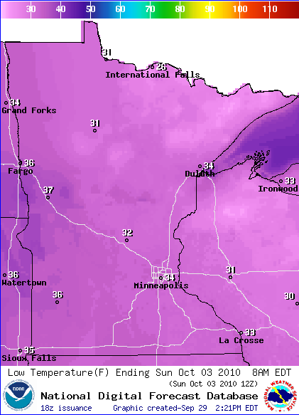
* First frost of the season possible in the outlying suburbs Sunday morning.
Paul's Conservation MN Outlook for the Twin Cities and all of Minnesota:
Today: Bright sun, breezy, a bit cooler than yesterday. Winds: NW 10-15. high: 67
Thursday night: Mostly clear and cool. Low: 47
Friday: Unsettled with mostly cloudy skies, a passing sprinkle, gusty (raw) wind. High: 62 (holding int he 50s most of the day).
Saturday: Chilliest day in sight. Partly sunny and brisk - feels more like late October. High: 57
Sunday: Blue sky, light breeze - a bit milder. High: 61
Monday: Plenty of sunshine, warming up. High: 65
Tuesday: Lot's of sun - beautiful weather statewide. High: 69
Wednesday: Sun fades behind increasing clouds - unseasonably mild. High: near 70
If we could just stuff days like yesterday into a bottle for safekeeping - open it up in a few months to savor (when we'll need it even more). I don't even want to think about wind chill, glare ice and "plowable snows." The sleds out in the shed (Polaris) help me rationalize snow, but it's tougher coming to grips with the intermittent arctic blasts. The only saving grace (which I've told friends and relatives ad nauseum) - our coldest days tend to be sunny. That blue sky does make a HUGE difference much of the winter, compared to cities like Chicago, Cleveland, and Milwaukee, where lake effect keeps it grayer with much higher humidity levels. When you're living in a town that has more moisture in the air the cold CUTS THROUGH YOU, to the point where 20-30 F. is painful. The coldest I've ever been (in my life) is NOT Minnesota, but Chicago, walking down Michigan Avenue, a raw 40 mph wind slapping me in the face, a temperature of 20 (above zero) but a humidity close to 100% made it feel like I was roaming around Antarctica. Unspeakable cold. All that moisture leaves your clothing damp, which conducts the cold far more efficiently - you FEEL the windchill in a way that makes Minnesota seem almost tame by comparison. Something to be said for living upwind of the Great Lakes. It's drier here - sunnier too. For most of us the worst days aren't the sunny (bitter) days, but rather the gray, humid, 30-degree days - the lack of sun seems to be a bigger factor than a lack of degrees most of the winter.
Sorry for going off on a meteorological tangent - just bracing myself (mentally) for what's to come. But the good news: we have plenty of lukewarm days left, more 60s, probably a few more 70s, I wouldn't be shocked to see another 80-degree high in October. I don't see anything that resembles a true COLD FRONT, but you'll probably need to break out the jackets and sweatshirts again by late Friday and Saturday as Canada fires off a warning shot. The sun will be out today, highs about 5-10 degrees cooler than yesterday. A reinforcing cool front surges into town Friday with more clouds, a stiff breeze and a few windblown sprinkles. You'll need a jacket or sweatshirt for Friday evening football games, temperatures falling through the 50s.
Saturday still looks like the coolest day in sight, highs in the 50s, a mix of clouds and sunshine - it will feel more like late October. Frost? A distinct possibility in the outlying suburbs by Sunday morning. The "urban heat island", heat being re-radiated from asphalt and concrete, will keep the immediate metro area a few degrees warmer Saturday night, but 20-40 miles away from the downtowns it will be a different story. The first week of October is pretty typical for a first-frost, at least in the suburbs. The growing season in downtown St. Paul and Minneapolis is 2 weeks longer than the 'burbs - the first 32 in South Minneapolis routinely comes at least a week later than it does in Delano, Andover, Lino Lakes and Lakeville. There's some hot trivia you can use at your next party (if you want to be standing alone, talking to yourself).
Sunday should be a notch nicer, light southerly winds, afternoon highs topping 60, bright sun (fewer scrappy cumulus clouds) - a fine fall day. Temperatures continue to mellow thorugh next week, and right now it looks dry - the chance of showers next Wednesday has diminished - any significant fronts and storms detouring well south (or north) of Minnesota until further notice. This dry spell is coming at a VERY good time for farmers, still trying to get into their fields after last week's almost biblical deluge. Harvest has been delayed, no question - but it seems like the atmosphere will compensate for last week's flooding by treating us to 2, possibly 3 weeks in a row of dry weather. That's fairly unusual for October.
Sunshine will be the rule through most of next week - little or no rain, only a slight chance of frost Sunday morning, no high winds, severe weather or anything that remotely resembles a "storm" until the second week of October, at the earliest. This is as quiet as it ever gets this time of year. I'm going to kick back and enjoy this unusual (and welcome) lack of "weather".


No comments:
Post a Comment