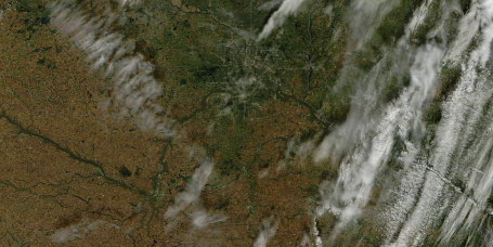
Flooding From Space. If you look VERY carefully you can see the Minnesota River spilling out of its banks in Tuesday's "MODIS" satellite image from NASA's Terra low-orbiting spacecraft. The very latest image can be found
here.
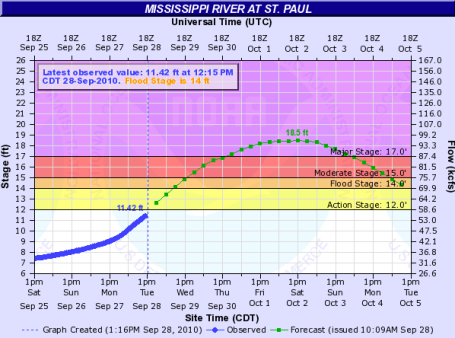
St. Paul Prediction. The Mississippi River is forecast to crest in St. Paul over the weekend, 4 1/2 feet above flood stage. Harriet Island will almost certainly be inundated as water from the Minnesota River surges downstream. People living in vulnerable neighborhoods along the Minnesota and the Mississippi Rivers should stay alert for the latest flood forecasts and local announcements. The latest forecast can be found
here.
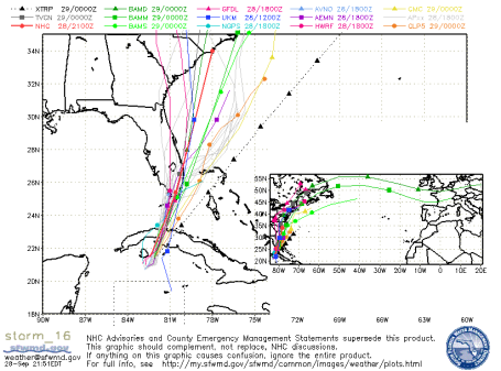
Nervous Floridians. An area of disturbed weather swirling south of Cuba is close to tropical storm strength, there is a better than 50/50 chance this tropical wave will mature into "Nicole", and then track north, across Cuba today, possibly threatening the southern and eastern counties of Florida with torrential rain and 40-60 mph. winds by Thursday. More from NHC
here. An ensemble of multiple models can be found
here. The storm is forecast to soak Florida today, and then accelerate right up the east coast, producing torrential rains from Savannah to Washington D.C. and New York.
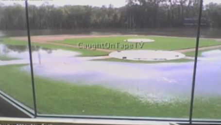
Instant Flood. Click here to see an amazing time-lapse of the Chaska Athletic Field getting inundated on Sunday - this lapse goes from 6:00 am to 7:30 pm, a little over a 12 hour period. Amazing.
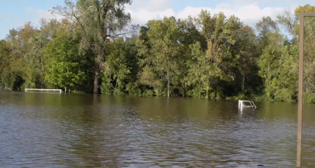
Northfield Flooding. The soccer fields in Northfield have also been inundated by last week's 6-10" rainfall. The YouTube video clip is
here.
How Hot Did It REALLY Get In Los Angeles Monday? You probably heard by now - the official NWS thermometer broke shortly after the mercury soared to 113 F, setting a new all-time record for L.A. (coming in Autumn - very odd). More on the quirky weather gripping southern California from the L.A. Times
here.
SoCal Heatwave Leaves Thousands Without Power. The record-smashing 113 F high in L.A. on Monday left tens of thousands of residents without power - a bad time to be without air conditioning, the "marine layer" (cool, moist Pacific air sweeping in from the west) nowhere to be found. More on the record-breaking heat (and malfunctioning thermometer)
here from USA Today.
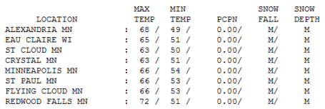
Tuesday Stats. Yesterday was the definition of "partly sunny", or possibly another phrase we use way too much: "a mix of clouds and sun". It started out sunny, clouds rolled in (from the north and east, a touch of lake effect sweeping off Lake Superior) and then the sun reappeared during the afternoon as skies cleared from west to east. A typical fall day in Minnesota, rain-free, highs ranging from 63 at St. Cloud to 66 in the Twin Cities, a respectable 72 at Redwood Falls.
* Slight chance of a shower north of St. Cloud and Mille Lacs this afternoon -
today should be the mildest day in sight.
* Cooling trend into Saturday - dig out the light jackets & sweatshirts for the end of the week.
* Saturday: coolest day in sight,
slight chance of frost late Saturday night over central and northern Minnesota.
* Sunday: a few degrees warmer - blue sky, a light south/southwest breeze at 10-15 mph.
Paul's Conservation MN Outlook for the Twin Cities and all of Minnesota:
Today: Partly sunny, breezy and mild. A few PM showers possible, mainly over northern and central MN. Winds: SW/NW 10-20. High: 73
Wednesday night: Clearing and cool. Low: 53
Thursday: A mix of clouds and sun, a few degrees cooler. High: 62
Friday: Clouds increase - slight chance of a PM shower or sprinkle. High: near 60
Saturday: Blue sky, coolest day in sight (light winds). High: 58
Sunday: Still sunny, a bit milder (probably the nicer day of the weekend). High: 61
Monday: Sunshine lingers - feeling even better out there. High: 67
Tuesday: Sunny start, clouds increase late. High: 68
Wednesday: Cloudy with a good chance of showers. High: 64
Yes, it finally feels like fall out there. No dew point-babble, no dueling Dopplers on TV, no "watches" or "warnings" to muddle through or swatting of the NOAA Weather Radio up in my study (which must have gone off 2 dozen times in the middle of the night during the summer months). Yesterday's raw north breeze pumped in low-level moisture all the way from the Lake Superior area, keeping a stale slab of stratocumulus clouds hovering overhead much of the morning and midday - skies finally cleared from west to east and we were able to salvage a fine Tuesday evening.
Today will be the warmest day in sight - a good chance of low to mid 70s by mid afternoon as winds increase from the south ahead of an Alberta Clipper, clouds increasing as the afternoon goes on. This clipper may spark a few showers over northern and even central Minnesota during the afternoon and evening hours - maybe a half hour of rain from St. Cloud on north. That's the only rain in sight for the next week or so - there's a slight chance of a shower late Friday as a reinforcing cool front dives south of the border - the next chance of (widespread) showers will come next Tuesday night and Wednesday, but until then it's relatively smooth sailing in the weather department.
Mea culpa: the predicted weekend temperatures are definitely cooler than we were predicting a few days ago (when it looked like we might eek out a 70-degree high by Sunday). Each computer run has trended progressively cooler and cooler, we'll be lucky to see 50s (for highs) on Saturday under a mostly-blue sky, after a frosty start central and northern counties we should inch up to 60 or so Sunday afternoon. A southwest breeze kicks up early next week with highs mellowing into the 60s to near 70 by Tuesday and Wednesday, not bad at all for the first week of October.
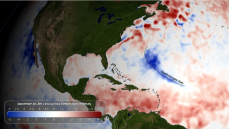
NOAA Satellites Crucial in Accurate Hurricane Forecasting. NOAA has 5 "GOES" satellites, in permanent orbit 22,300 miles above the equator, and 2 additional low-orbiting "POES" satellites that fly over the poles at an altitude a little over 200 miles above the ground. This image shows a cold "wake" of water left behind by Hurricane Igor. Hurricanes tap warm water and convert tropical ocean water into wind and rain - dredging up cooler water in their wake. The article from NOAA is
here.
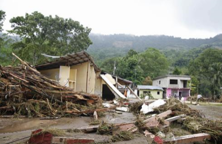
Hundreds Feared Dead in Mexican Landslide. The state of Oaxaca, Mexico has been inundated by heavy rains in recent days, as many as 100-300 homes were buried - as many as 500 to 1,000 people may have been in those homes, still missing. As much as 28" of rain may have fallen in a single week. USA Today has more on the historic flooding and resulting mudslides
here.
Wild Time Lapse. There are some amazing videos on YouTube - including
this wild example shot last weekend in Vancouver - 3 different layers of clouds at various altitudes - quite a sight.


No comments:
Post a Comment