* Flooding expected on the Minnesota River - including south metro of the Twin Cities. For the very latest flood specifics from the NWS click here.

Watches & Warnings. All those red counties south of the Twin Cities are under flood WARNINGS, meaning flooding is imminent - happening now. Flood watches are posted for central MN and much of Wisconsin - if the sun does peek through later this afternoon a round of severe storms may rumble across southeastern MN.
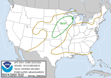
Slight Risk of Severe Storms. SPC has pushed the "slight risk" into roughly the southeastern third of Minnesota, including the Twin Cities metro. If (and it's a big if) the sun DOES pop out this afternoon - that will be a warning sign - meaning the atmosphere is on the verge of being extremely unstable, capable of T-storms with hail and damaging winds. Of course any additional storms may pour out some additional 1-3"+ rains, any additional water will immediately run off into streets, streams and basements, making the flood problems even worse across southern MN.
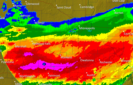
Half a FOOT of rain! Latest Doppler rainfall estimates (as of 9:15 am) show some 6" amounts from near Worthington and Marshall east to Mankato and Owatonna - flood warnings are in effect for much of southern MN - meaning that flooding is occurring NOW - conditions will get progressively worse through the afternoon, not improving until late tonight - if you live in a flood-prone region stay alert and be ready to move to higher ground. Reports of 9+" of rain near Amboy, in Blue Earth county - I'm starting to think there may be EXTREME flooding south of the metro into the evening hours.
Singing In The Rain! This is how I wish I could react to a dreadfully waterlogged Thursday. Just once I have to try this (but not today). Good luck out there - expect commute times 2-3 times normal, with lot's of standing water on area highways, and a heightened risk of fender-benders. Not a pretty day on the roads. The latest NAM/WRF model prints out 1.17" of rain in the metro area by tonight - 2 week's worth of rain in a little more than 24 hours. Much of central MN will see 3-4" of rain by tonight.

 Peak Oil: How Much Is Left? Leading geophysicists predict that peak oil (when we're extracting the most oil from the ground) is either occurring now - or is inevitable between now and 2015. After that time the quantity of oil pumped out of the ground will begin to decline, at the same time demand continues to spike worldwide. According to oil giant BP "the supply will never peak." Some interesting statistics on oil consumption here.
 Funnels Over The Big Apple. This is the first YouTube video I've seen showing the actual tornado funnel that formed over Brooklyn and Queens, not the kind of sight you'd expect to see over America's largest metropolitan area. Now I've officially seen everything. Rated PG-13 for a few choice words (if I saw a tornado forming in the skies over New York City I might have uttered those same words...)
 The New Math. Florida has $433 billion worth of coastal property insured by the state's insurance program - yet only $10.5 billion in cash on-hand to pay out any claims. Not good. Some would argue it's a (financial/insurance) disaster just waiting to happen.
 How To Die In A Hurricane. CBS News has an intriguing article about apathy in Hurricane Alley. The best way to become an eventual hurricane victim? #1: Refuse to make preparations. Don't think about what a hurricane to do to you and your family. #2: Don't identify the safest place in your house to ride out a storm. #3: Don't worry about pets or vaccination records necessary if you have to take them to an emergency shelter. #4: Be outside when the hurricane strikes. #5: Turn on your propane tanks. #6: Don't stock up on food, water or first aid supplies. Don't fill up your bathtub with water. #7: Stay in your mobile home. #8: Don't turn on your radio or check your batteries. #9: Don't think about escape routes before the storm approaches. #10: Talk on a conventional phone, ignore the fact that the electricity is almost guaranteed to go out. It's amazing how many people living within a few miles of the ocean or Gulf of Mexico do NOT have a plan in place, oblivious to the dangers involved. This entry is from a pastor with a unique perspective on storms, tragedies and human nature.
 Hurricanes May Cost Beyond Those Hit. USA Today has an interesting article about the insurance costs passed along to all of us by people who live along the coast. Katrina in 2005 was a real eye-opener for the insurance industry. An estimated $632 billion in property is now insured in 8 coastal states from Texas to North Carolina, but those states only have $6 billion in reserves, another $12 billion in reinsurance funds to cover any eventual payouts. Many officials are concerned that there isn't nearly enough money to cover eventual claims from a direct strike, another (almost inevitable) Katrina. They argue that we're living in denial, whistling past the graveyard. Somehow ALL of us wind up paying a premium for the recent uptick in damaging hurricanes. A democratic solution - but is it fair to people who live hundreds or even thousands of miles away from "Hurricane Alley"?
 Warning: Professional Pessimists Should Probably Avoid This Game. Video games are supposed to be an escape from reality. This "game" hits a little too close to home for most gamers - a group of Oxford scientists collaborated to create a hands-on way for young people to get up to speed on the potential perils of climate change. Based on their actions - gamers can sample from a number of different climate scenarios - taking steps to minimize some of the fallout, and potentially save the world. More on this (odd but timely) game from the Christian Science Monitor here.
 A Soggy Summer To Remember. This map from the meteorology department at Iowa State shows 20+ days with at least an inch or more of rain from central Iowa into much of Missouri since April 1. 1"+ daily amounts were recorded on 6-10 days across much of central and southern Minnesota. As soggy as it's been close to home, it's been far wetter a few hundred miles to our south. More here.
 Wednesday Transition. After a sunny start clouds rapidly increased, a swarm of strong/severe storms rumbling across far southern Minnesota during the afternoon hours with 1-2" hail. Rare for late September, but certainly not unprecedented. Highs ranged from 59 at Alexandria and 60 at St. Cloud to 64 in the Twin Cities, 66 at Eau Claire, WI. As of 7 pm Wednesday evening .06" of rain had already fallen in the Twin Cities, .53" at Rochester.
__________________________________________________
Paul's Conservation MN Outlook for the Twin Cities and all of Minnesota:
Today: Flash Flood Watch. Rain, heavy at times - a few embedded T-storms possible. Some street and stream flooding can't be ruled out. Winds: SE 10-20. High: 72
Thursday night: Rain tapers to showers late. Low: 55
Friday: Windy and cooler. Morning clouds and showers giving way to slow PM clearing (should be dry for evening football games). High: near 60 (holding in the 50s across most of Minnesota).
Saturday: Some morning sun, then increasing clouds, a few PM showers. High: 66
Sunday: Nicer day of the weekend, more sun, breezy and milder. High: near 70
Monday: Blue sky, lukewarm - VERY nice! High: 73
Tuesday: Plenty of sunshine, still beautiful. High: 71
Wednesday: Sun giving way to increasing high clouds. High: near 70
____________________________________________________
There is a 99.9% probability your drip-dries will be drooping today. The first full day of autumn will take "soggy" to a whole new level - as much as a MONTH'S worth of rain may fall by the breakfast hour tomorrow as a slow moving storm throws a shield of steady/heavy rain into Minnesota. Models vacillate between 1-3" from St. Cloud to the Twin Cities, to as much as 4"+ from the Iron Range to Hayward, Wisconsin. This is the kind of gulley-gushing, window-rattling rainstorm you might expect to see in early June.....but late September? Very odd.
 Atmospheric Tug-Of-War. Warm, tropical air lurking just south of Minnesota is surging northward, rising and cooling as it lifts over a dome of unusually cool, dry air over the Great Lakes. This rapid upward motion causes air to cool, as air cool it loses its ability to hold water vapor - invisible water vapor condenses out into visible cloud droplets - which eventually coalesce (combine) to form larger rain drops - when they get big enough gravity pulls them to the ground as rain. I know, more than you really wanted to know...
The core of the jet stream, the main superhighway for storms, is a few hundred miles farther south than usual for late September, howling directly overhead. That means more rapid weather changes than usual, frequent frontal passages and storms whipping from west to east. The greater the "baroclinicity" (the stronger the north-south temperature contrasts) the more potential energy available to fuel a storm. Considering we're seeing 40s and 50s just north, and 80s and 90s a few hundred miles to our south, there's plenty of energy available to the storm sloshing overhead today, and that should result in some ridiculous amounts of rain. Some towns will easily set a 24-hour rainfall record. Because the ground is already saturated and waterlogged, the local NWS has issued a "Flash Flood Watch" for most of central and east central Minnesota and the northern half of Wisconsin - meaning conditions are ripe for flooding problems: wet basements, swollen streams, inundated intersections capable of making the daily commute an exercise in futility.
 Slight Severe Risk Far South. According to SPC a few strong/severe storms may brush the MN/IA border today, enough moisture and wind shear in the lowest 5,000 feet for hail and potentially damaging winds from near Worthington to Albert Lea.
Find your Happy Place. You're going to need to psyche yourself out a little today (and hold your breath as you make a mad dash to and from your vehicle). A character-building fall day - the first full day of autumn, by the way. The sun is as high in the sky as it was on March 22 - making it even more remarkable that highs may surge into the low 70s south of the Minnesota River, holding in the 60s elsewhere.
 A Month's Worth Of Rain In 36 Hours? The latest NAM/WRF model prints out the heaviest rain bands from the Minnesota Arrowhead into northern Wisconsin, where some 4"+ amounts are possible. Anywhere from 1-3" is predicted from St. Cloud to the Twin Cities, significantly lesser amounts over far southeastern Minnesota.
This is an IMPRESSIVE storm - it's slow movement prolonging the rain, chalking up outrageous rainfall amounts for September. A plume of tropical moisture is surging northward across the Plains states, fueling this deepening area of low pressure, some of this may be the tropical remains of Hurricane Georgette, which formed over the Pacific, coming ashore near Baja Mexico, sending a swirl of moisture into the Desert Southwest, flooding out parts of Texas, making our day a little bit more unpleasant and soggy around the edges.
The storm finally pushes east on Friday, winds switch around to the northwest (10-20 mph with higher gusts) allowing drier, Canadian air to percolate southward, pushing the heaviest rains into Wisconsin. Clouds may linger much of the day (showers lingering near Duluth) but odds favor a dry afternoon and evening - no major weather complications for Friday evening football games - but take a sweatshirt of blanket - it will definitely feel like Autumn out there as temperatures fall through the 50s with a distinct whiff of wind chill.
Saturday should start out partly sunny and promising, but a lingering puddle of cold air swirling several miles over Minnesota may spark a few PM instability showers. It won't be like today, but an hour or two of rain can't be ruled out Saturday, best chance coming between lunch and the dinner hour. Highs may hold in the 50s, nicking 60 over southern counties. Sunday still looks better as this (ill-timed) "upper air disturbance" pinwheels east and the atmosphere becomes more stable. That should translate into more sun, highs well up into the 60s to near 70 south and west of the Minnesota River. Models are hinting at a string of low 70s the first few days of next week.
Yes, now that September is winding down - now it appears that we'll finally sample some authentic September weather between September 26-30. Better late than never, I guess.
 Fall Colors. This is one of the best explanations I've read about how and why leaves turn vivid colors during the autumn months. If you're curious (or have a couple more minutes to kill) click here - graphics and information courtesy of USA Today.
 Ripening Up. The shorter daylight coupled with cooler temperatures means an acceleration of fall color across the state. According to the MN DNR 25-50% of the leaves have ripened up from the Twin Cities to St. Cloud, but 50-75% of the trees are close to peak color from Mille Lacs on north to Hinkley, Grand Rapids and the North Shore. Peak color is roughly 1 week away along the Lake Superior shoreline, maybe 10 days away for the immediate Twin Cities. For more information on which trails and parks have boasting rights click here.
 Typhoon Fanapi Aftermath. This is the scene in Taiwan, cleaning up from a devastating typhoon (same phenomenon as a hurricane). Winds gusted up to 100 mph, at least 100 injuries and 2 fatalities blamed on the storm - more here.
 Arctic In "Surprising" Double-Dip Melt. Specially-equipped weather satellites flying over the North Pole have been measuring the amount of Arctic ice melt for 32 years. According to the National Snow and Ice Data Center 2010 will go down into the record books as the second or third greatest retreat of Arctic ice on record. 2007 saw the most melting, followed by 2008, but a recent (second dip) in arctic sea ice may produce a virtual tie between 2008 and 2010 for the #2 spot. Quoting from the story, "satellite records date back to 1979, but ice cores and other data indicate that the rate of melting is unprecedented and can only be explained by the heat-trapping accumulation of greenhouse gases in the atmosphere. Another concern: positive feedback: as highly reflective (white) ice melts, the resulting (darker) ocean water has a lower "albedo", absorbing more of the sun's energy, creating even more warming, which melts more ice, accelerating the ice-melt cycle. More on what's happening in the Arctic here.
 Average Monthly Arctic Sea Ice Extent (Aug. 1979 - 2010). Data based on satellite observations.

 Validating The "Hockey Stick". Two more studies confirm the scientific validity of the "hockey stick" - recent global warming is unprecedented in its magnitude, speed and cause. Michael Mann, a Phd from Penn State, has received criticism for somehow "cooking the books" and making the recent global warming trend more sinister-looking than the data really suggests - he's even gotten death threats from climate change deniers. Now come two new reports that essentially confirm what Mann's research suggested years ago. The atmosphere is now thought to be warmer than any time in the last 2,000 years. There have been natural warming trends in the past, no question, but what makes the CURRENT warming trend unique: we're seeing it in both hemispheres, and it can't be explained away by astronomical triggers (earth's orbit closer to the sun, etc). For more information on the hockey stick debate click here.
 Southern California Summer To End With A Chill: It Was The Coldest In Decades. Minnesota enjoyed a warmer summer than much of California - for Los Angeles it was the chilliest August since 1944. The reason? A trough of low pressure lingering from the Gulf of Alaska to the California coast - triggering an unusual number of cool, damp, gray days. So although global temperatures are ramping up, and 2010 will probably be the warmest year on record worldwide, there are (and always will be) exceptions to the rule. More from the L.A. Times here.
 NOAA: Coral Bleaching Likely In The Caribbean This Year. Based on water temperatures which have been warmer than average all year long - NOAA is predicting that bleaching of coral in the southern and southeastern Caribbean may be as bad as 2005, when 80% of coral bleached and as much as 40% of coral reefs died from the unusual warmth. More on the risk here.
No comments:
Post a Comment