Monsoon Season. Welcome to Guam - with lakes. 2-4" of rain soaked the Twin Cities metro area yesterday, a month's worth of rain in many communities. We set a record for the wettest September 23 (modern-day records go back to 1891). As much as 10" swamped south central Minnesota. Photo courtesy of KARE-11.
* 1.88" at MSP International Thursday, setting a new rainfall record for September 23. The old record was 1.2" on September 23, 1977.

* 24 hour rainfall at MSP: 2.82" (close to a month's worth of rain).
* 2.79" reported at Chanhassen. Additional rainfall reports from the CoCoRaHS network here.

A "Hurricane's Worth of Rain". Doppler radar estimates from the Chanhassen NWS show a huge area of 6-8" rains just north of I-90, from near Worthington westward to Mankato and Owatonna - hundreds of square miles received a minimum of 6", with over 10.53" at Amboy, MN and 10.2" at Truman. USA Today has more on the scope of the flooding, which extended into southwestern MN here.
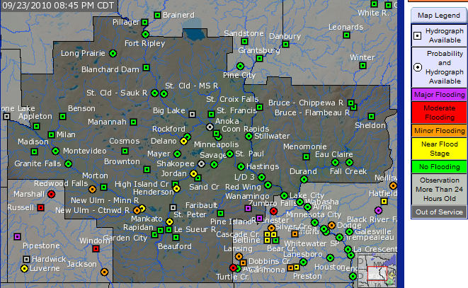
Flood Potential. Here is the very latest from NOAA's river flood forecasting division, showing a potential for major flooding near Zumbro Falls, Pine Island and Rochester. The Minnesota River may approach flood stage in Jordan, some minor flooding on the Crow River near Delano.

Major Flood Potential. The North Fork of the Zumbro River near Wanamingo may reach 25 feet early this morning, over 3 feet above major flood stage.

Perspective. According to Pete Boulay at the MN State Climatology Office Thursday's deluge was probably the most rain to fall on southern MN since September 14-15, 2004. Statewide it may have been the most significant flood event since August 18-20, 2007. More detail from the MN State Climatology Office on where this flood ranks in Minnesota weather history here. The National Weather Service provides some additional historical perspective here.

Top 5 Worst Summers? O.K. This is somewhat subjective, but still interesting (in my humble opinion). According to the Weather Channel the following cities take top honors (?) for the "worst weather of the summer."
#1). Washington D.C. Swarms of severe thunderstorms with significant damage. 4 days over 100, 63 days over 90 F, coupled with drought conditions much of the summer.
#2). Little Rock, Arkansas. It was the hottest summer ever with 21 days over 100 F, 111 days (a third of the year!) over 90 F.
#3). Des Moines, Iowa. The capital of Iowa picked up 30" of rain over the summer, twice as much as average. It was the second wettest summer on record, second only to 1993. More from the Des Moines Register on Iowa's manic summer here.
#4). Brownsville, Texas. This city in southern Texas had the distinction of being hit by a hurricane, a tropical storm and a tropical depression.
#5). Los Angeles. It was an unusually cool and cloudy summer, the second coolest in L.A.'s history. Only 22 days were warmer than average.
* Nationwide the USA just experienced the 4th warmest summer on record.
* 10 states had the hottest summer ever recorded: TN, AL, GA, SC, NC, VA, MD, DE, NJ and RI.
* According to Pete Boulay at the Minnesota State Climatology Office Thursday's excessive rain across southern Minnesota may have been the most significant rain event since September 14-15, 2004, the worst flood in 6 years. He adds that there have been similar (extreme) rainfalls similar to this one during September. "I would not characterize this as rare," he added.

Wow. 1.88" rain fell at MSP International since midnight - a new record for September 23 (old record was 1.2" on September 23, 1977). But the 24-hour rainfall total was 2.82", which is close to what we would normally see the entire month of September! 1.5" fell at St. Cloud, 3.11" at Redwood Falls, a whopping 4.75" soaked Rochester - amazing.
_______________________________________________
Paul's Conservation MN Outlook for the Twin Cities and all of Minnesota:
Today: Mostly cloudy, windy and cooler with a few windblown sprinkles (but drying out as the day goes on). A few peeks of sun are possible later. Winds: NW 15-25. High: 61 (holding the 50s over most of MN).
Friday night: Dry for evening football games (take a sweatshirt/blanket). Partly cloudy as winds ease. Low: 49
Saturday: Morning sun giving way to increasing clouds, a passing PM shower. Winds: SE 8-13. High: near 60
Sunday: The nicer day, more sun - probably dry. High: 69
Monday: Bright sun, lukewarm - a beautiful September day. High: 74
Tuesday: Blue sky - hard to focus on work or school. High: 75
Wednesday: Weather-winning-streak continues, plenty of sunshine. High: 77
Thursday: Lot's of sun, turning breezy and cooler. High: 68
_____________________________________________
Is it safe to take off the life preserver yet? Yesterday I almost drowned running out to my car - good thing I held my breath. What a day. You just don't expect a TORRENTIAL rain in late September, on the first full day of Autumn! Just when you think you've seen everything, along comes September 23, a day when over 10" of rain plastered a few towns in south central Minnesota.
What happened? Models were hinting at some 4"+ amounts (but those same models were suggesting that the heaviest bands would set up over central and northern Minnesota). Off by 200 miles, give or take - but the models had the right idea. Nobody in there right mind would predict 10 INCHES OF RAIN in late September, it's so far off the mark, 2 to 3 times more than what you might expect from the most extreme rain event in late September - we were all caught with our Dopplers down. We mentioned a flooding potential Tuesday and Wednesday, but 10" amounts? That's so far off the scale it's almost unimaginable. For June? Yes, within the realm of possibility. But late September? No.
A "train echo" event is responsible for the 6-10"+ amounts that swamped southern Minnesota. We've talked about this before - much like the cars in a train repeatedly pass over the same section of track, thunderstorms kept forming, dying and re-forming over southern Minnesota. The first round of storms tracked across far southern Minnesota Wednesday afternoon, dumping 1-3". Then another swarm of storms formed overnight, then another and another, resulting in some eye-popping amounts by Thursday afternoon. Again, VERY unusual for this time of year, but that's the kind of summer season we've had - exceptional. Iowa, southern Wisconsin and Illinois bore the brunt of this train echo phenomenon much of the summer, to have it shift northward and set up over southern Minnesota on the first full day of Autumn - well, it was a sobering and somewhat humbling thing to see on the weather maps.
The monsoon season is over (for now) - a drying northwest wind chases the heaviest rains into the Great Lakes today, the sun may peek through later, northwest winds gusting to 25 mph at times - temperatures holding in the 50s to near 60 over far southern Minnesota. Expect a dry sky for evening football games, but take a jacket or sweatshirt as temperatures fall through the low 50s into the upper 40s, the wind making it feel like 40-45 F at gametime.
Saturday should be another step in the right direction with some morning sun, a wrinkle of cold air aloft capable of sparking a few PM showers - but MOST of Saturday should be dry, still on the cool side though. Sunday still looks like the finer day of the weekend as temperatures aloft warm up, the sky floating over Minnesota more stable and agreeable, enough blue sky for highs well up into the 60s.
Farmers are concerned, and rightfully so - standing water in many fields south of the Minnesota River. The good news: long-range (GFS) models keep us basically dry from Sunday through October 9 - no significant rain in sight next week, or the week after that. It looks like we compensate for yesterday's epic flood with an extended dry spell as the atmosphere tries to "even things out", a little cosmic payoff for a miserably wet Thursday.
We're due for a fine spell of weather. It's been June in September - give it a few more days and September may just redeem itself. Don't write off fine, lukewarm (quiet) weather just yet...

Indiana Brushfires. While we slog through pond-size puddles a nagging drought is lingering over much of the Midwest and Ohio Valley, over 1,000 acres in Indiana up in smoke from raging brushfires - the town of Williamstown had to be evacuated as strong winds pushed a wall of flames towards the town - more here.

Mysterious Weather. "Red rain", ball lightning, fire tornadoes, mammatus clouds - the list of crazy weather goes on. I found this article somewhat interesting, taking some of the mystery out of some of nature's crazier displays of wild weather phenomena.

New Satellite Records Stunning Video. The brand-new GOES-15 weather satellite from NOAA can snap a new picture once a minute. That compares with once every 5 to 7.5 minutes for previous GOES weather satellites. Why does this matter? The new satellite shows a level of accuracy and granularity not seen before - this can make a huge difference for NHC forecasters in Miami trying to determine if a hurricane is strengthening, or if a "overshooting top" sprouting on the top of a T-storm anvil implies large hail or a developing tornado. Minutes can make a huge difference with severe storms. More on the new advancements in satellite technology from the DiscoveryChannel here.

Don't Trash The Phonebook! Conservation Minnesota reminds all of us not to waste a perfectly good phone book. Granted - many of us go on-line now to look up a phone number. 20,000 Minnesotans have already visited this site, opting out altogether, or deciding to use and ultimately recycle - but please don't trash your phone book!

* Does "Global Warming" Need A Makeover? Remember, it's "global climate disruption" now. Doesn't quite roll of the tongue huh? The story is here.
No comments:
Post a Comment