* Storm-Free. Quiet Next Week. What is going on? October is more like September, nearly a MONTH of dry, uneventful weather. Then we get a superstorm stronger (at least in terms of central pressure) than most hurricanes. Then 2 more weeks of (yawn) quiet, uneventful weather. Welcome to the Year of All or Nothing. We slowly warm up next week - no major storms in sight, all computer models keep us dry through next weekend.
* Hints of Indian Summer? Computer guidance hinting at highs in the low to mid 50s for the first weekend of November, the 6th-7th.
* Hints of Winter After Nov. 13 The GFS model is suggesting that significantly colder weather may be on the way for the third full week of November. By then the bloom may be off the rose...


Not Quite As Record-Setting? The National Weather Service in Duluth has a great story about Tuesday's low pressure "bomb", with an altitude-corrected barometric pressure of 28.21" over Bigfork, MN at 5:13 pm. The previous record was 28.43" set on November 10, 1998 at Austin and Albert Lea. It turns out it was certainly the strongest storm ever recorded over Minnesota and the Upper Midwest, probably the most intense storm ever measured between the Rockies and the Appalacians. NCDC confirms a pressure of 28.20" in 1913 (Canton, New York) and 1932 (Block Island, Rhode Island) - we may have missed a continental (non-tropical) record by a lousy .01" of a millibar. The lowest pressure ever recorded? The small, incredibly intense hurricane that devastated the Florida Keys in 1932 had a barometric pressure of 26.34". And a 1997 storm over Dutch Harbor, Alaska had a central pressure of 27.35", which is almost unimaginable for a non-hurricane pressure event. A tip of the hat to the Duluth NWS, their well-researched story is here.
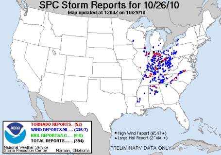 Major Outbreak. SPC reported close to 70 tornadoes Tuesday and Wednesday of this week as one of the strongest storms in U.S. history intensified over the Upper Midwest, dragging a squall line across much of the Ohio Valley. It was the largest 48 hour outbreak of tornadoes since late June. There were 336 reports of damage caused by high winds. More from SPC here.
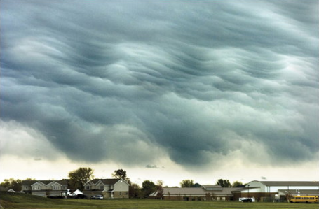
Wave Clouds. A photographer in Manteno, Illinois captured this impressive shot of wave clouds (triggered by a sharp inversion, temperatures warming with altitude) last Tuesday, as the explosive storm was spinning up over the Minnesota Arrowhead.
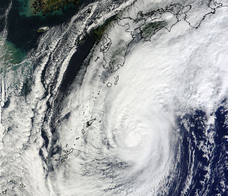
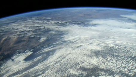
Typhoon Chaba Forecast To Brush Japan. From NASA: "Typhoon Chaba is forecast to brush the eastern side of the main island of Japan this weekend, and NASA's Terra satellite captured an impressive visual image of the storm today as it continues northeastward through the Northwestern Pacific Ocean. At 1500 UTC (11 a.m. EDT) on Oct. 29, Typhoon Chaba's maximum sustained winds were now at 80 knots (92 mph) down from 100 knots (115 mph) just 24 hours before. It was about 460 nautical miles southwest of Yokosuka, Japan near 29.9 North and 134.9 East. It was moving northeast near 16 knots (18 mph) and kicking up 23-foot high waves." The complete story from NASA is here.
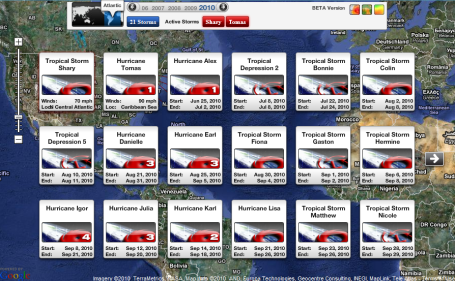
Third Most Named Storms In An Atlantic Hurricane Season. According to Jeff Masters at Wunderblog 2010 now ties 1995 and 1887 for the third most named storms in an Atlantic hurricane season. Quoting Masters, "Only 2005 (28 named storms) and 1933 (21 named storms) were busier. Atlantic hurricane records go back to 1851, though there were likely many missed named storms prior to the beginning of satellite coverage in the mid 1960s. The intensification of Shary and Tomas into hurricanes today brings the total number of hurricanes this season to 12, tying 2010 with 1969 and 1887 for second place for most hurricanes in a season. The record is held by 2005, with 15 hurricanes, and I don't think we'll beat that record this year! The formation of Tomas so far south and east this late in the season is unprecedented in the historical record, no named storm has ever been present east of the Lesser Antilles (61.5 degrees W) and south of 12 degrees N latitude so late in the year." The rest of Masters' excellent blog is here.
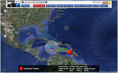
Hurricane Tomas - in early November? Unusual, but hardly unprecedented, hurricanes tend to be most likely during the late summer and early fall months, when water temperatures peak. Tomas is packing 90 mph sustained winds - now moving away from St. Vincent and St. Lucia. What is almost miraculous: 12 hurricanes and NOT ONE DIRECT HIT on the USA. We got really lucky this year. Map courtesy of NHC and Ham Weather.
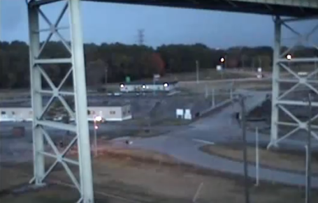
Possible Tornado Caught On Security Camera. The midweek tornado outbreak was caught on a webcam outside of Chattanooga, Tennessee - there is some debate whether this footage shows true evidence of a tornado, or possibly an intense gust-front or "gustnado", a swirling vortex on the leading edge of damaging, straight-line winds. Whatever it was, it picked up those large trailers and sent them flying. Another perspective in HD can be seen here.
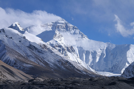 3G On The Summit Of Mount Everest. You heard right - if you ever had the urge to fire up your iPad during a rigour climb of the world's tallest mountain - now you're all set. "Nepali mobile network operator Ncell has installed the first 3G base station at the base camp of Mount Everest, giving visitors, climbers and people living in the Khumbu Valley the ability to make calls and wirelessly connect to the Internet. To test out the new facility, Ncell also made the world’s highest video call at 17,388 feet." Great news! The complete story is here.
The World's Most Expensive Single-Family Home? 27 stories, 6 levels of parking, 3 helipads on the roof, airborne swimming pools, 9 elevators and a grand ballroom - all for 5 people in downtown Mumbai (formerly known as Bombay). The cost? At least $1 billion, but possibly much higher than that - the NY Times has the story of the most over-the-top home every constructed here.

Best iPhone Apps? I know - it's subjective, but in the spirit of "news you can use" (at least if you own an iPhone) here is Gizmodo's pick of the best apps out there right now.
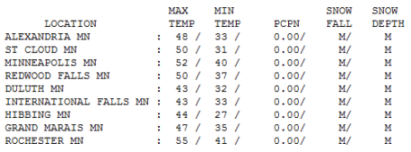
Perfectly Normal. Under a sunny sky temperatures were within a few degrees of "normal", whatever that is. No rain reported anywhere in the state, highs ranged from 43 at Duluth and International Falls to 50 in St. Cloud, 52 in the Twin Cities and 55 at Rochester. Not bad at all for late October.
Paul's Conservation MN Outlook for the Twin Cities and all of Minnesota:
HALLOWEEN: Bats on Doppler, nothing else. Plenty of sun, light winds. NE 5-10. High: 48
SUNDAY NIGHT: Mostly clear and chilly. Frost likely late. Low: 30
MONDAY: Plenty of sunshine, still quiet. High: 52
TUESDAY: Dry roads for Election Day, ample sunshine. High: 54
WEDNESDAY: Blue sky, touch of Indian Summer, a few degrees milder. High: 56
THURSDAY: Clipper cools us off again, sunny and brisk. High: 49
FRIDAY: Still sunny, still boring (for meteorologists). Good news for you. High: 48
SATURDAY: Partly sunny, no weather worries. High: near 50
Partly Spooky
Look at the bright side: we could be knee-deep in snow right now. 19 years ago the Halloween Superstorm dumped over 8" on Oct. 31, on our way to 28.4" in the cities, a single-storm record. Duluth picked up an astounding 36.9" with 5-10 foot drifts. The Duluth NWS reports that last Tuesday's 28.21" barometric pressure at Bigfork was probably the strongest storm ever observed between the Rockies & the Appalachians. A 1913 storm over New York & a 1932 storm over Rhode Island registered central pressures of 28.20"; We missed a lower 48 non-tropical record by .01" millibar!
The all-time record low pressure: 26.34" during a small, incredibly powerful hurricane that leveled the Florida Keys in 1932. That said, Tuesday's storm was extraordinary.
Halloween '10 will be cooler than average, but the sun will be out with light winds, under 8 mph. Kids will need hefty jackets under those costumes, but rain gear (or boots) will be optional this year. Quiet weather lingers into next week, no rain (or snow) in sight, just mid 50s by midweek, followed by a cooling trend late week. No arctic smacks brewing, but by next weekend the east coast may feel the full fury of a classic Nor'easter.
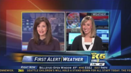
"IVY.TV" Talk about disruptive technology. Now you can get live streaming TV stations (and the major networks) on your computer. Free for the first month, then $4.99/month after that, for a buck more you can even record programs to play back later (on your PC or Mac!) I found out about this site during the Cablevision/Fox squabble - apparently Cablevision was directing people to this site to see the World Series (since Fox was withholding their signals for nearly 3 million households). Apparently the major networks are suing Ivytv.com for Copyright Enfringement, but Ivy claims it's all perfectly legal, and they will be sending royalty checks to the ABC's, CBS's, Fox's and NBC's of the world. It will be interesting to see how this plays out - but at least for now you can stream (live) TV on your PC/Mac - the local stations are from New York City and Seattle, with a few other channels thrown in. It's definitely worth checking out. (images above from KIRO and KING-TV in Seattle, which I was streaming live yesterday). Yes, it's a brave new media world out there. What happened to music, publishing, magazines and newspapers is about to happen to local TV. Welcome to a new ala carte, always-on, all-you-can-eat digital world.
 World's Most Amazing Monorails. I don't know why this struck a chord - but it did. I remember riding the Disneyland Monorail, brought back some good memories. They are so futuristic in a Buck Rogers kind of way. Gizmodo has a great story about the most memorable monorails on the planet here.
Ignoring The Planet Won't Fix It. The New York Times ran an article about new research which (for some reason) failed to get much traction earlier this week. Quoting the article, "It concluded that, over the next 30 years, warming temperatures associated with climate change were likely to create increasingly dry conditions in the United States and droughts around the globe on levels seldom seen before. Previous studies by Dr. Aiguo Dai have indicated that climate change may already be producing drier conditions. A 2004 study found that the percentage of the world’s land area facing serious drought more than doubled from the 1970s to the early 2000s. The recent study concluded that most of the western two-thirds of the United States will be significantly drier by the 2030s, and that large parts of the nation may face an increasing risk of extreme drought. This is not about melting ice caps; it’s about Dust Bowl-style drought within two decades."
Global Warming "Unquestionably" Linked To Humans: France. From an article posted by the AFP: Global warming exists and is unquestionably due to human activity, the French Academy of Science said in a report published Thursday and written by 120 scientists from France and abroad. "Several independent indicators show an increase in global warming from 1975 to 2003. This increase is mainly due to the increase in the concentration of carbon dioxide," the academy said in conclusion to the report. "The increase in carbon dioxide, and to a lesser degree other greenhouse gases, is unquestionably due to human activity," said the report, adopted unanimously by academy members.
 As Seas Rise, Future Floats. Worldwide sea levels rose just under 8" during the 20th century. The IPCC is predicting sea level rises of anywhere from 18 - 59 centimeters this century. 11 of the world's 15 largest cities are situated on coastal estuaries, very much at risk of rising water levels. So the notion of floating factories, homes, even entire cities, isn't quite as far-fetched as it may sound. Cue Kevin Costner. The article is here.
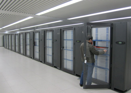 China Wrests Supercomputer Title from U.S. A Chinese research center has just built the fastest supercomputer ever made, thought to be about 1.4 times faster than the U.S.'s fastest machine, in Tennessee. The possible implications here.
No comments:
Post a Comment