* Light Jacket Weekend. A cooler front arrives over the weekend, keeping highs mostly in the 40s (low 50s possible far southern MN, including the Twin Cities).
* Quiet Next Week. We slowly warm up next week - no major storms in sight.
* Hints of Indian Summer? Computer guidance hinting at 55-60 degree highs for the first weekend of November, the 6th-7th.
* Wet, slushy snow between November 11-13? The GFS model is suggesting that this may be the first chance of any real accumulation looking out the next 2 weeks.
Halloween Outlook For The Twin Cities: Witch Watch, Werewolf Warning in effect. Partly cloudy and dry, late afternoon/evening temperatures ranging from 39-44 F, a light east breeze at 3-8 mph. All in all pretty typical for the last day of October. We've seen worse!
Pumpkin "Sculpting". Suddenly my lame pumpkin-carving capabilities look even more pathetic than usual. Click here to see some mind-boggling examples of what you can do with a pumpkin!

Not Quite As Record-Setting? The National Weather Service in Duluth has a great story about Tuesday's low pressure "bomb", with an altitude-corrected barometric pressure of 28.21" over Bigfork, MN at 5:13 pm. The previous record was 28.43" set on November 10, 1998 at Austin and Albert Lea. It turns out it was certainly the strongest storm ever recorded over Minnesota and the Upper Midwest, probably the most intense storm ever measured between the Rockies and the Appalacians. NCDC confirms a pressure of 28.20" in 1913 (Canton, New York) and 1932 (Block Island, Rhode Island) - we may have missed a continental (non-tropical) record by a lousy .01" of a millibar. The lowest pressure ever recorded? The small, incredibly intense hurricane that devastated the Florida Keys in 1932 had a barometric pressure of 26.34". And a 1997 storm over Dutch Harbor, Alaska had a central pressure of 27.35", which is almost unimaginable for a non-hurricane pressure event. A tip of the hat to the Duluth NWS, their well-researched story is here.
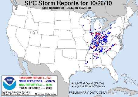 Major Outbreak. SPC reported close to 70 tornadoes Tuesday and Wednesday of this week as one of the strongest storms in U.S. history intensified over the Upper Midwest, dragging a squall line across much of the Ohio Valley. It was the largest 48 hour outbreak of tornadoes since late June. There were 336 reports of damage caused by high winds. More from SPC here.
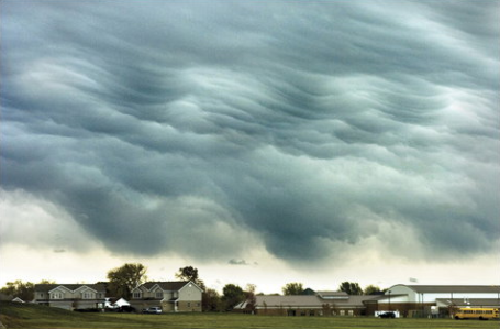
Wave Clouds. A photographer in Manteno, Illinois captured this impressive shot of wave clouds (triggered by a sharp inversion, temperatures warming with altitude) last Tuesday, as the explosive storm was spinning up over the Minnesota Arrowhead.
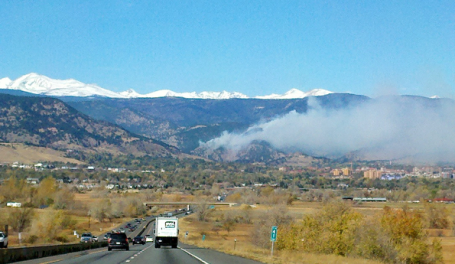
Boulder Brushfire. A small 25 acre brushfire threatened a neighborhood outside of Boulder, Colorado for a time on Saturday, but fire fighters managed to contain the blaze. More from 9News in Denver here. Click here to see YouTube footage of the blaze.
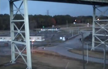
Possible Tornado Caught On Security Camera. The midweek tornado outbreak was caught on a webcam outside of Chattanooga, Tennessee - there is some debate whether this footage shows true evidence of a tornado, or possibly an intense gust-front or "gustnado", a swirling vortex on the leading edge of damaging, straight-line winds. Whatever it was, it picked up those large trailers and sent them flying. Another perspective in HD can be seen here.
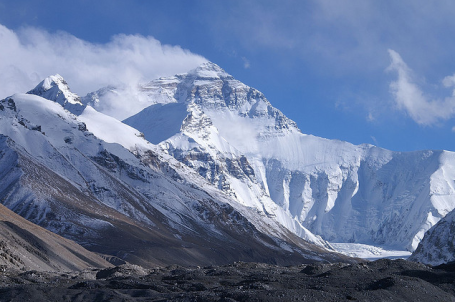 3G On The Summit Of Mount Everest. You heard right - if you ever had the urge to fire up your iPad during a rigour climb of the world's tallest mountain - now you're all set. "Nepali mobile network operator Ncell has installed the first 3G base station at the base camp of Mount Everest, giving visitors, climbers and people living in the Khumbu Valley the ability to make calls and wirelessly connect to the Internet. To test out the new facility, Ncell also made the world’s highest video call at 17,388 feet." Great news! The complete story is here.
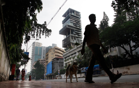
The World's Most Expensive Single-Family Home? 27 stories, 6 levels of parking, 3 helipads on the roof, airborne swimming pools, 9 elevators and a grand ballroom - all for 5 people in downtown Mumbai (formerly known as Bombay). The cost? At least $1 billion, but possibly much higher than that - the NY Times has the story of the most over-the-top home every constructed here.
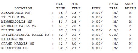
Fine Friday. Nice to see the sun out - luring the mercury close to normal for late October. No rain was observed statewide, highs ranged from a brisk 37 at Duluth to 50 in St. Cloud, 53 in the Twin Cities and 61 at Redwood Falls.
SATURDAY: Plenty of sun, brisk. Winds: NW 10-15 High: 51
SATURDAY NIGHT: Mostly clear and seasonably chilly - more frost likely. Low: 30
HALLOWEEN: Happy Halloween! Lot's of sun, breezy and cool - risk of cavities. High: 48
MONDAY: Bright sun, slightly milder. High: near 50
TUESDAY: Quiet Election Day. Sunshine lingers, breezy and a bit milder. High: 54
WEDNESDAY: Dry, hints of Indian Summer with more sun than clouds. High: 58
THURSDAY: Storm-free. No weather complaints. Still sunny and dry. High: 56
FRIDAY: Sun fades, still October-like. High: 53
Stump the weather guy
Man, am I ever fun at parties. Not. "Paul, when can you call a warm spell Indian Summer?" Hmm. The expression is usually defined as "the first abnormally mild weather after the first official frost of the season." The low at KMSP dipped to 28 F Friday morning, making it the 10th latest frost on record for the Twin Cities (coming 3 weeks later than usual). The growing season is at least 2-3 weeks longer in the downtowns than it is in Chanhassen, Lakeville and Stillwater.
At Delta's World Perks Club yesterday: "Paul, my sinuses are going crazy; everyone I know is suffering. Was it that crazy storm?" Probably. We experienced the 2nd lowest air pressure on record (28.6" at MSP) and the rapid CHANGES we endured earlier this week affect air cavities in our bodies, resulting in discomfort. A lot of walking, talking, (sniffling) barometers out there.
At least the sun is out through Halloween and Election Day. No more mega-storms or "Landicanes" in sight. A reinforcing Canadian high keeps us sunny and brisk this weekend (heavy jackets under costumes Sunday PM). 40s & 50s are likely next week, an outside chance of 60 by the 1st weekend of November; turning sharply colder after the 10th.
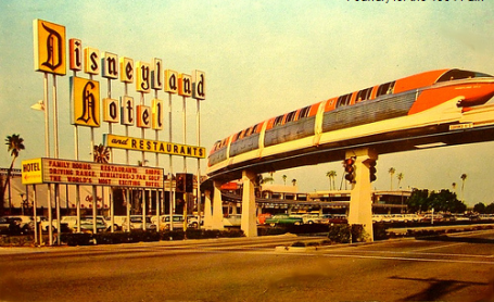
World's Most Amazing Monorails. I don't know why this struck a chord - but it did. I remember riding the Disneyland Monorail, brought back some good memories. They are so futuristic in a Buck Rogers kind of way. Gizmodo has a great story about the most memorable monorails on the planet here.
Ignoring The Planet Won't Fix It. The New York Times ran an article about new research which (for some reason) failed to get much traction earlier this week. Quoting the article, "It concluded that, over the next 30 years, warming temperatures associated with climate change were likely to create increasingly dry conditions in the United States and droughts around the globe on levels seldom seen before. Previous studies by Dr. Aiguo Dai have indicated that climate change may already be producing drier conditions. A 2004 study found that the percentage of the world’s land area facing serious drought more than doubled from the 1970s to the early 2000s. The recent study concluded that most of the western two-thirds of the United States will be significantly drier by the 2030s, and that large parts of the nation may face an increasing risk of extreme drought. This is not about melting ice caps; it’s about Dust Bowl-style drought within two decades."
Global Warming "Unquestionably" Linked To Humans: France. From an article posted by the AFP: Global warming exists and is unquestionably due to human activity, the French Academy of Science said in a report published Thursday and written by 120 scientists from France and abroad. "Several independent indicators show an increase in global warming from 1975 to 2003. This increase is mainly due to the increase in the concentration of carbon dioxide," the academy said in conclusion to the report. "The increase in carbon dioxide, and to a lesser degree other greenhouse gases, is unquestionably due to human activity," said the report, adopted unanimously by academy members.

As Seas Rise, Future Floats. Worldwide sea levels rose just under 8" during the 20th century. The IPCC is predicting sea level rises of anywhere from 18 - 59 centimeters this century. 11 of the world's 15 largest cities are situated on coastal estuaries, very much at risk of rising water levels. So the notion of floating factories, homes, even entire cities, isn't quite as far-fetched as it may sound. Cue Kevin Costner. The article is here.
No comments:
Post a Comment