* First frost of the season reported across much of Minnesota Sunday morning (including the north metro).
* This week: probably the best weather of the entire autumn season.
* 70s likely from Wednesday into Monday of next week, 10-15 degrees above average.
* No rain until next Tuesday, October 12.
* This week: probably the best weather of the entire autumn season.
* 70s likely from Wednesday into Monday of next week, 10-15 degrees above average.
* No rain until next Tuesday, October 12.
First Frost. Sunday morning lows dipped to 32 at Blaine, 31 at Brooklyn Center, 30 at Cambridge and a nippy 28 at Lakeville - but the central and southern suburbs of the Twin Cities stayed above the freezing mark. St. Cloud saw its first frost as well, Sunday AM temperatures bottoming out at 30 F.
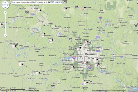
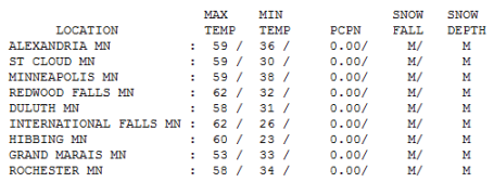
Superb Sunday. After a frosty start in many towns afternoon temperatures recovered to near 60 across much of the state, a high of 59 at MSP and St. Cloud, 60 in Hibbing and 62 at Redwood Falls under a flawless blue sky.
Paul's Conservation MN Outlook for the Twin Cities and all of Minnesota:
Today: Sunny and beautiful. S 3-8. High: 66. Low: 39
Tuesday: Blue sky, lukewarm. High: 70. Low: 46
Wednesday: Still sunny, amazing. High: 74. Low: 52
Thursday: Hard to concentrate. High: 71 Low: 51
Friday: Spectacularly sunny. High: 75. Low: 55
Saturday: Best weekend of October? High: 77. Low: 58
Sunday: Plenty of sun, memorable. High: 73. Low: 57
“Best week of autumn”
I messed up. I made the mistake of taking my boat out of the water last week. Duh. Here we are, faced with what should be the best week of autumn, 8-9 more picture-postcard days of blue sky and lukewarm afternoons, highs reaching well into the 70s by the weekend. This may be Mother Nature’s way of apologizing for a cooler, wetter than normal September. No rain until the middle of next week, just a flawless sky, low humidity, gentle breezes. As good as it gets.
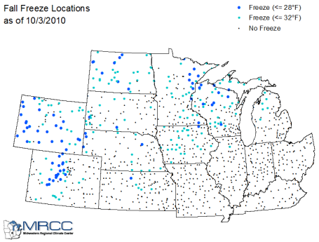
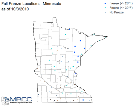
Much of greater Minnesota saw the first frost/freeze of the season Sunday morning, but much of the metro area remained frost-free, no risk of plants freezing their buds off until the third week of October at the earliest. The scene outside my window looks like an explosion at a paint factory, splatters of lime, rust and lemon dripping from every tree. Make the most of this extraordinary week. At some point the law of averages will catch up with us. As inevitable as gravity, at some point that low sun angle will burst our warm-weather bubble.
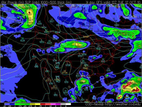
Next Chance Of Rain. Great news for farmer and other waterlogged Minnesotans - basically dry weather should linger into early next week, storms detouring well south and north of Minnesota for at least the next 7-8 days. The next chance of rain: next Tuesday, the 12th of October, according to the GFS model.
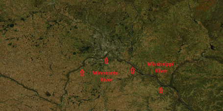
Typical - For April. Sunday's 250 meter, high-resolution "Aqua" satellite from NASA showed both the Minnesota and Mississippi Rivers running at bankful, in many low-lying areas still well out of its banks, the result of a September that was 3-5 times wetter than average across many southern Minnesota counties. To see the latest MODIS satellite image from NASA click here.
No comments:
Post a Comment