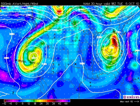
"Omega Block." Here is the 500 mb (18,000 foot) forecast for winds aloft today around noon, showing closed-off or "occluded" storms stalled over the east coast, another storm in a holding pattern centered over California. Normally this time of year weather systems push from west to east at 20-30 mph. But not this week. With storms stalled over both coasts a fair-weather ridge of high pressure will stall out over the Midwest and Plains, keeping us unusually sunny and mild through at least Monday of next week. This kind of a holding pattern is rare, but hardly unprecedented, setting up once every 2-3 months, on average. See the raw model data for yourself
here, data courtesy of Unisys.
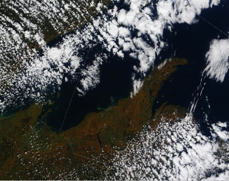
 Ripening Colors From Space
. You can see the progression of color over the last 3 weeks over northern Wisconsin and the U.P. of Michigan on NASA's "MODIS" Terra satellite. Click
here for a time-lapse showing the acceleration of color up north since September 19, 2010.
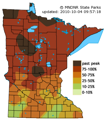
Past Peak. According to the Minnesota DNR fall foliage is past-peak in the Little Falls/Wadena area, as well as Bemidji and International Falls, close to peak color right now along the North Shore of Lake Superior. Next weekend colors should be approaching their peak from the Twin Cities on south/east - maybe a good weekend to hop in the car and drive down Highway 61 toward Lake Pepin, Lake City and Winona. Click
here to see the latest update from the DNR.
* 80 F. not out of the question by the weekend south/west of the Minnesota River, nearly 20 degrees above average!
* Nationwide it was the 4th warmest September in 50 years for the USA and all of North America, the warmest since 2005. September was also the 8th wettest in 50 years across North America. More from Planalytics here.
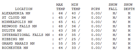
Magnificent Monday. Not a bad way to start a new week at work or school: bright sun, highs in the 60s (except for poor Grand Marais, where the high was only 55). Afternoon temperatures peaked at 65 in St. Cloud and the Twin Cities, 67 at Hibbing and 68 at Redwood Falls. By Sunday temperatures may be 10 degrees warmer than this.
One Scary Video. Halloween is now within striking distance (do you have your costume picked out yet?) If you really want to get scared check out
this JibJab video from the entire WeatherNation team. Sorry - I'm just the messenger.
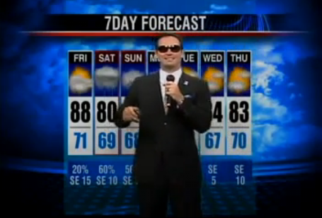
Rapping Weather Man. Just when you thought you saw everything there was to see on the Internet, along comes
this clip. Turns out meteorologist (?) Nick Kosir made the move from Beaumont, Texas (market # 141) to San Francisco (market #6). That gig lasted 2 days. Apparently the station didn't hire his wife, so he abruptly quit - now he's working in Twin Falls, Idaho (market # 192). What a wild trip, in less than a couple of weeks! More on Nick's wild (rapping) weather adventure
here.
Paul's Conservation MN Outlook for the Twin Cities and all of Minnesota:
Today: Sunny, windy and mild. Winds: S 15-25. High: near 70
Tuesday night: Mostly clear and seasonably cool. Low: 50
Wednesday: Blue sky, pretty spectacular. high: 69
Thursday: Sunny with a lukewarm breeze. Impossible to focus. High: 70
Friday: Sunny, unseasonably mild, 10-15 degrees above average. High: 72
Saturday: Kicking off the best weekend of October, one of the nicest of the entire fall season. Mostly sunny and beautiful. High: 74
Sunday: Plenty of sun, possibly the warmest day in sight. High: 76
Monday: Sun fades behind high clouds, still balmy. High: 75
The weather verdict is short and extra-sweet: sunny & spectacular through early next week. No chance of rain. Temperatures 10-20 degrees above average for this time of year (normal high now is 60 F. in the metro area). Friends and colleagues looking for (lame) excuses to sneak outside. I'm not exaggerating when I say this will be the BEST WEEK OF AUTUMN, and remarkably, this Chamber Of Commerce-Worthy weather will spill over into next weekend, when the mercury may brush 80 F. south and west of the Minnesota River. Yes, now that it's October now we're finally getting the September we never really enjoyed. Remember, the atmosphere tends to "even things out." Unusually cool, wet weather is usually (but not always) followed by spells of equally warm & dry weather. Considering September rainfall was 2-5 times higher than average across most of Minnesota, we're due for a swing in the other direction.
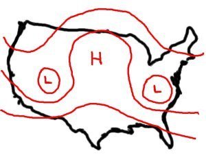
If you use your imagination the upper-level wind pattern looks a little like the Greek letter "Omega". Storms anchored over New England and California - stalled, stuck, going nowhere. Sandwiched in-between these sloppy storms: an expansive bubble of high pressure stalled out over the Plains and Upper Midwest. This holding pattern crops up every couple of months, and we get the benefits of this stagnant flow. Instead of clipping along at 20-25 mph a bubble of high pressure over the Great Lakes will park itself over Detroit until further notice, keeping our skies remarkably sunny and balmy for the next week or so. The next chance of rain? A week from today, Tuesday, October 12, give or take a day, when the block will finally break down and some of that western moisture will finally streak in from the Dakotas. Until then, welcome to Palm Springs, San Diego, Tucson, take your pick. Bottom line: you will NOT want to spend much time inside between now and next Monday.
Extended computer models keep us well above average through the 20th of October, highs reaching well into the 60s through the third week of October. At some point reality will catch up with us and a MUCH colder front will come barreling southward out of Canada. Maybe we'll pay a price come late October, but as far as I dare look out (about 15-17 days) the pattern looks more like mid September than classic October weather. Get ready for one of the more memorable Octobers in recent history - this may wind up being one for the record books.
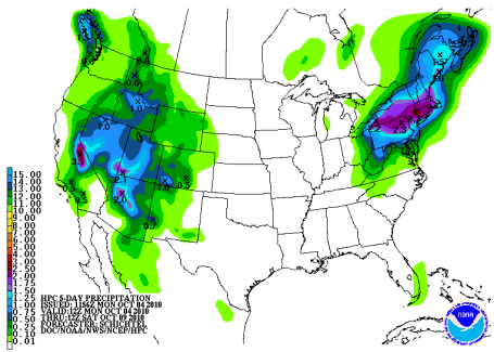
Dry Spell. The QPF, short for "quantitative precipitation analysis" shows heavy rain over the northeast and parts of the western U.S. this week, but not a drop of rain predicted for the central U.S. as high pressure remains stalled overhead.
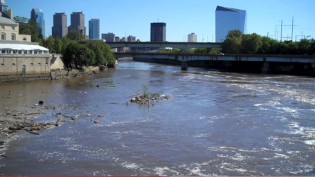
Philadelphia Flooding. Waters are just now beginning to recede out east after last week's torrential 6-12" rainfall amounts from Tropical Storm Nicole.
This YouTube clip shows the extent of flooding still taking place in the Philadelphia area.
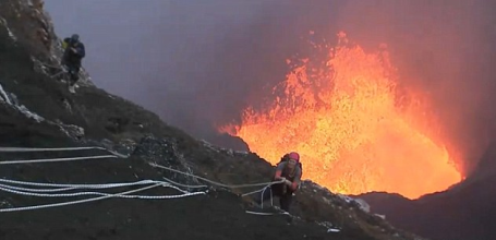
Too Hot To Handle: Daredevils abseil into a live, erupting volcano. Talk about extreme sports - a group of (patently insane) climbers - with protective gear including oxygen bottles - lowered themselves into an active volcano 400 miles from Australia - the result was one of the most spectacular
videos I've ever seen.
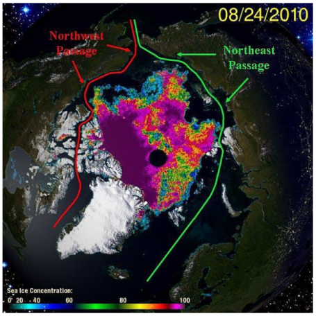
Arctic Transformed At Hands of Climate Change. This summer marked the 4th year in a row - the 4th time in recorded history, that ships were able to successfully navigate the "Northwest Passage", sailing from the Atlantic to the Pacific NORTH of Canada! That's how thin (or in many cases nonexistant) Arctic ice has become - 18 separate ships have made the voyage - something that would have been unthinkable 10-20 years ago. Another fluke? Maybe, but something is happening in the Arctic Region - more on the transformation going on up north
here.
Getting Past The Politics of Climate Change. In 2009 energy-related carbon emissions dropped by 7% in the United States, possibly a symptom of the severe recession, but the trends are encouraging. Political gridlock in Washington D.C. has hampered the prospects of a climate and energy bill anytime soon, while the rest of the world continues to look to America for leadership. A good summary of where we are, politically, in
this New York Times editorial.
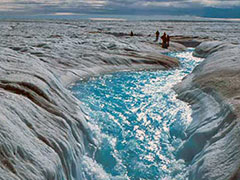 NASA Study Sees Earth's Water Cycle Pulse Quickening
. Freshwater is flowing into Earth's ocean in greater amounts every year, thanks to more frequent and extreme storms related to global warming, according to a first-of-its-kind study by a team of NASA and university researchers.
They found 18 percent more water fed into the world's ocean from rivers and melting polar ice sheets in 2006 than in 1994. The average annual rise was 1.5 percent. "That might not sound like much – 1.5 percent a year – but after a few decades, it's huge," said Jay Famiglietti, UC Irvine Earth system science professor and principal investigator on the study, published this week in the Proceedings of the National Academy of Sciences. He noted that while freshwater is essential to humans and ecosystems, the rain is falling in all the wrong places, for all the wrong reasons.
"In general, more water is good," Famiglietti said. "But here's the problem: Not everybody is getting more rainfall, and those who are may not need it. What we're seeing is exactly what the Intergovernmental Panel on Climate Change predicted – that precipitation is increasing in the tropics and the Arctic Circle with heavier, more punishing storms. Meanwhile, hundreds of millions of people live in semiarid regions, and those are drying up."The complete article from NASA is
here.
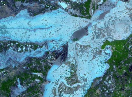 Historic Pakistan Flooding
. In late July 2010, flooding caused by heavy monsoon rains began in several regions of Pakistan, including the Khyber Pakhtunkhwa, Sindh, Punjab and parts of Baluchistan. According to the Associated Press, the floods have affected about one-fifth of the country. Tens of thousands of villages have been flooded, more than 1,500 people have been killed, and millions have been left homeless. The floodwaters are not expected to fully recede before late August.
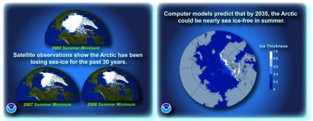
Ice-Free Arctic Within 30 Years? NOAA has a special web site focused on changes taking place in the Arctic region - computer models predict that by 2035 the Arctic could be nearly sea ice-free during the summer months. More
here. A good overview of the rapid changes underway north of the Arctic Circle
here.
How NOT To Get The Public Engaged In A Productive Climate Change Discussion. An eco-interest group, the U.K.'s "10:10" produced a little mini-movie called "No Pressure", in which the handful of people not interested in the topic of climate change get "blown up". Not helpful. Not productive - this just plays into the hands of skeptics who rail on climate change advocates as having a hidden agenda. It reinforces every negative stereotype out there - and I was a bit horrified when I first saw the
video myself. Warning: video is rated R for violence and simulated blood. We have to stop shouting at each other, stop shocking each other into believing one way or the other - let the scientists speak, and have a reasonable (adult) conversation about what is happening. But this? Pathetic.





No comments:
Post a Comment